The Maltese Islands
CLIMATE
OF THE MALTESE ISLANDS
The Maltese Islands enjoy a typical Mediterranean climate. The year is made up of two very different seasons; a hot and dry summer followed by a cool and wet winter. The transition between the two is sudden, but no definite time for when this occurs exists.
We must first look at the local climate within a geographical context. The seasonal features of the Maltese climate can be attributed to the motion and development of systems of low pressure over the Atlantic, Europe and Africa. Spring is often a period of indecisive weather, as the weather across the Mediterranean starts shifting to summer. Summer is characterized by the intensification of the Azores High, which very often extends towards the central Mediterranean. This brings sunny skies, hot temperatures and light and variable winds to the Maltese Islands. Autumn is very short. In winter, mid-latitude depressions move eastward across northern Europe and into the Mediterranean, bringing with them blasts of cold air. As this cold air comes into contact with warm moist air causing vertical instability locally, the mid-latitude depressions strengthen. Waves of cold air from over the Arctic can lead to even strong mid-latitude depressions.
Both Sicily and Tunisia influence our weather. Sicily can act as a barrier against strong winds from the North. Sicily creates local instabilities due to daytime heating of the land. These may be advected towards the Maltese Islands in the presence of favourable winds.
The annual mean temperature of the Maltese Islands stands at 18.2°C with mean monthly temperatures ranging from 12.7°C in January to 27.1°C in August. Usually, the coldest month is February, whilst the warmest is August. A very prominent characteristic of temperatures in the Maltese Islands is the rarity of diurnal and seasonal temperature range. This is due to the sea’s moderating effect. The sea is practically warm throughout the year, and its effect can be felt from any point on the islands, because of their very small size. During snaps of cold and especially during hail storms, however, temperatures can fall to below 5°C. This is another rarity.
Rainfall patterns how that the yearly average rainfall is considerably low at 585.6 mm. This is also unreliable, as one year can be much wetter and the next can be much drier. The wettest year locally was in 1859, when a total of 1031 mm of rain was measured. On the other hand, the driest year was 1894, when a total of 191 mm of rain was measured. A very brief analysis of rainfall distribution immediately shows that little or no rainfall falls in the summer months. The Maltese Islands experience a yearly drought during this period. Rainfall is at its highest during the autumn and early winter months, when rain tends to fall in thunderstorms which are usually heavy and at times also severe with large hail, funnels and strong wind. This is the result of cold fronts which are associated with the mid-latitude depressions which cross over the islands during the wet season. The wettest month is December, with 112 mm. Rain is the main source of precipitation with hail occurring during the coldest months. Although being unheard of by many, snow reportedly covered the ground on certain occasions but with little accumulation in inland areas.
Wind in the Maltese Islands is very common because it is an island in the middle of the mid-latitude depressions’ path and in a band of pressure difference. On average, 92% of all days experience winds of at least Force 2. This means that only 25 days a year are windless. The predominant wind direction is the Northwest, for the reason that the Maltese Islands lie in the westerly trade wind zone. An analysis shows that the windiest months of the year are between early October and late February, when gale force winds are quite common. The wind direction plays a very important part in the weather conditions on a particular day. The Northwest wind is cool and refreshing in summer, but cold in winter. The Southwest brings days of grey clouds and high humidity, and sometimes also red sand from the Sahara Desert. The Northeast wind is the most damaging wind locally, most probably due to the alignment of the Maltese Islands. Transient North African low pressure systems sometimes produce a very strong wind across the central Mediterranean.
The Maltese Islands, given their geographical position as islands have to cope with levels of consistently high relative humidity. It is for most of the time in the range between 65% and 85%, and rarely falls below 50%. At night, relative humidity is higher, as water condenses due to lower temperatures. The high humidity brings heavy dewfall and mist or fog on clear nights with light wind.
The Maltese Islands are among the sunniest in Europe. They experience up to 8.2 hours of bright sunshine a day.
| Month | Jan | Feb | Mar | Apr | May | Jun | Jul | Aug | Sep | Oct | Nov | Dec | Year |
|---|---|---|---|---|---|---|---|---|---|---|---|---|---|
| Mean Maximum Temperature (°C) | 15.6 | 15.6 | 17.1 | 19.8 | 23.9 | 28.5 | 31.6 | 31.7 | 28.5 | 24.9 | 20.9 | 17.2 | 22.9 |
| Mean Temperature (°C) | 12.8 | 12.7 | 14.0 | 16.4 | 19.9 | 24.2 | 27.0 | 27.5 | 25.0 | 21.7 | 18.0 | 14.5 | 19.5 |
| Mean Minimum Temperature (°C) | 10.1 | 9.7 | 10.9 | 13.0 | 15.9 | 19.8 | 22.5 | 23.3 | 21.6 | 18.5 | 15.2 | 11.9 | 16.0 |
| Mean Relative Humidity (%) | 78.4 | 78.3 | 78.1 | 77.1 | 74.5 | 70.5 | 70.2 | 73.6 | 76.6 | 77.7 | 77.6 | 78.9 | 76.0 |
| Mean Atmospheric Pressure (hPa) | 1021.7 | 1020.2 | 1017.3 | 1016.3 | 1015.9 | 1015.1 | 1014.6 | 1014.1 | 1016.7 | 1017.8 | 1016.3 | 1018.0 | 1017.0 |
| Mean Wind Speed (km/h) | 15.7 | 15.8 | 16 | 15.9 | 15.0 | 12.6 | 11.6 | 11.0 | 11.9 | 12.1 | 13.9 | 15.2 | 13.9 |
| Total Rainfall (mm) | 69.4 | 61.9 | 40.3 | 17.0 | 9.8 | 4.1 | 0.2 | 10.6 | 54.9 | 84.0 | 94.2 | 83.0 | 529.8 |
| Rain Days | 14 | 11 | 9 | 6 | 4 | 1 | 0 | 1 | 5 | 10 | 11 | 13 | 83 |
| Thunderstorm Days | 4 | 3 | 2 | 1 | 1 | 1 | 0 | 1 | 3 | 6 | 5 | 3 | 30 |
| Hail Days | 2 | 2 | 1 | 0 | 0 | 0 | 0 | 0 | 0 | 1 | 1 | 2 | 9 |
Records
Highest Temperature (°C)
Lowest Temperature (°C)
Highest Gust (km/h)
Highest Atmospheric Pressure (hPa)
Lowest Atmospheric Pressure (hPa)
Highest 24 Hour Rainfall (mm)
HISTORY OF METEOROLOGY
IN THE MALTESE ISLANDS
Given our island’s strategic location in the Mediterranean, and its ownership passing from one empire to the next, meteorological observations in Malta have always been of utmost importance. The oldest known rainfall records date back to 1851 while those of temperature date back to 1865. These were collected by instruments at the University of Malta in Valletta. The first known meteorological office started operating in 1922 at Guardamangia, moving to St John’s Cavalier just five years later. In 1947, the national office was relocated to the airport in Luqa where it can still be found till this day. In 1979, the office fell under the civil aviation’s remit. World War II was seemingly a turning point for meteorology in the Maltese Islands. This is obvious from the state and quality of the records before and after this date. Quality continued improving gradually in the years after.
An interesting fact is that in the year 1882, a fully functional observatory was inaugurated in a specially built wing within the premises of Sacred Heart Seminary in Victoria, Gozo. This observatory operated until 1909.
Nowadays, modern technology, satellites and computers provide us with a more detailed and accurate picture of the weather in Malta, allowing constant updates and careful tracking of weather systems. MalteseIslandsWeather.com makes use of these modern means to provide you with a single point of reference for all the weather updates you will need.
GEOLOGY
OF THE MALTESE ISLANDS
The Maltese Islands are made up entirely of sedimentary rock. Sedimentary rocks are types of rock that are formed by the deposition and subsequent cementation of mineral or organic particles on the floor of oceans or other bodies of water at the Earth’s surface. Cementation occurs as the overlying weight of sediment causes compaction, cementation and hardening. The sedimentary rock on the floor of oceans or other water bodies is raised to the surface by seismic activity. Once exposed, processes of erosion and weathering formed the countless landforms that characterise the Maltese Islands. The Maltese Islands are believed to have formed about 25 million years ago. Each stratum took millions of years to form. Afterwards, there must have been a form of uplift of the seabed. This was probably caused by collisions between African and Eurasian plates. As a result, rock-tops appeared above sea-level. This must have happened some 10 million years ago.
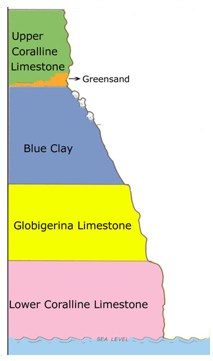
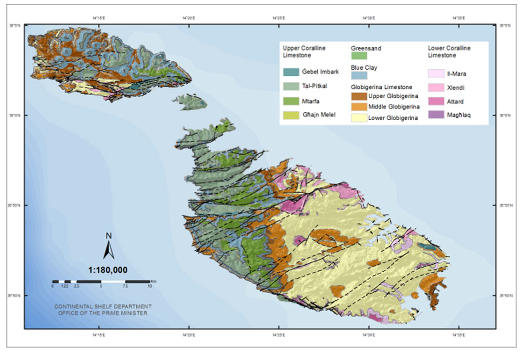
The stratigraphy of the Maltese islands consists of five geological formations:
- Lower Corraline Limestone: This layer of rock is the oldest in the Maltese Islands. It is normally found exposed on cliff faces. This can be seen at the two major cliff areas of the Maltese Islands; Ta’ Ċenċ in Gozo and Dingli in Malta. When found at the surface further inland, the Lower Corraline Limestone takes the shape of rugged barren plains. This is known as karstland. It is very common in the Baħar iċ-Ċagħaq area in Malta and Xlendi in Gozo. When quarried, Lower Corraline Limestone is often used as flagstones for pavements, in breakwaters and spall concrete mixtures.
- Globigerina Limestone: This is a softer yellowish fine-grained kind of limestone. The term Globigerina refers to a type of microscopically small fossil shells that are found in abundance in limestone. Where found at the surface, the Globigerina Limestone takes the form of gently sloping plains. The whole eastern side of Malta is covered in this rock. Because of its softness, it can be quarried easily. Globigerina Limestone is most suitable as a building stone. In fact, most buildings on the Maltese Islands are built of it.
- Blue Clay: This is the softest of all five rock types in the Maltese Islands. Since Blue Clay is very soft, it erodes away very quickly. When Blue Clay outgrows on a hillside, it slides and covers the layers beneath it. This is evident in Għajn Tuffieħa and Ġnejna Bay area. Blue Clay is the only impermeable layer of rock in the Maltese Islands. Thanks to this property, underground water reservoirs are formed. Soils formed from Blue Clay are very fertile, since they can remain moist and can better resist the heat of the sun. Gozo looks much greener than Malta for the simple reason that there are more areas with exposed Blue Clay.
- Greensands: The Greensands layer is much thinner than all other rock formations. It has a distinct colour, composition and position. It is also very friable. Thus, it tends to pulverize into sand easily. Greensands is most abundant on the Ta’ Ġurdan and Ta’ Gelmus hills in Gozo.
- Upper Corraline Limestone: This is the youngest layer of rock in the Maltese Islands. This limestone rock is generally exposed on hilltops and plateaus. The whole surface of Comino is composed of Upper Corraline Limestone. This rock is very important for industrial use since it is used for making spalls for road surfacing and also for concrete mixtures.
GEOMORPHOLOGY
OF THE MALTESE ISLANDS
Geomorphology is the study of the physical features of the surface of the earth and their relation to its geological structures. Two main physical processes are responsible for the topography of the Maltese Islands. These tectonic processes and processes of erosion.
Tectonic processes refer to the movement of the Earth’s major plates. Crustal movements of the seafloor have changed the way that sediments are created and deposited, causing rocks to fold, fracture and stretch.
Erosional processes refer to physical elements such as water, waves, acid rain and the heat of the Sun. All of these contribute to the disintegration of rock. Erosion of the different types of rock produces a wide range of different topography.
Because the Maltese Islands are made up mostly of limestone and are situated in a maritime setting, the result is the formation of many caves. Coastal erosion produces cliffline notches and sea caves at sea-level.
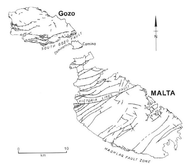
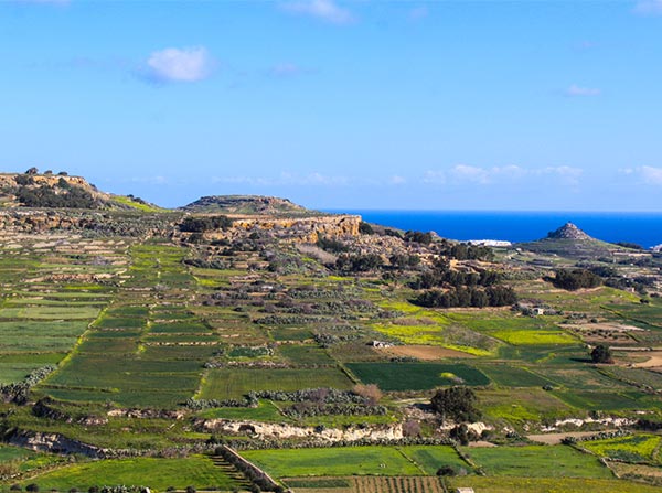
The Maltese Islands are split by two large faulting systems. These faults are the result of the African plate occasionally colliding with the Eurasian plate. The Great Fault splits the island of Malta into two. It runs from Fomm ir-Riħ on the southwest coast to Madliena on the northeast coast. This fault separates the region of ridges and valley across the northern half of Malta, from the plains across the southern half of the island. Rifting in the vicinity of the Maltese Islands has resulted in alternate uplifting of various regions. The most recent episode of rifting has given the archipelago a tilt to the northeast. As a result, the western part of the Maltese Islands is dominated by cliffs, while the eastern part of the Maltese Islands is dominated by low-lying rocky shores and beaches.
Faulting to the north of the Great Fault gives rise to a sequence of ridges and valleys, known as horsts and grabens in geomorphology. Proceeding from the Great Fault are: the Binġemma Basin, Wardija Ridge, Pwales Valley, Bajda Rudge, Mistra Valley, Mellieħa Ridge, Għadira Bay and Marfa Ridge. The channel between Malta and Gozo is also a series of horsts and grabens. The first graben in the sequence is inundated by the sea and forms the South Comino Channel, separating Malta from the island of Comino. The next horst is the island of Comino. The next graben is also inundated by the sea and forms the North Comino Channel, separating Gozo from the island of Comino.
Upper Coralline Limestone and Lower Coralline Limestone layers are often characterised by karst topography. Karst is composed of rugged and often barren plains of corroded rock. This is the result of rainwater. As rain falls through the atmosphere it collects carbon dioxide and becomes somewhat acidic. As the water percolates into the Upper Coralline Limestone and Lower Coralline Limestone it dissolves and carries away the calcium carbonate in the rock, leaving the other more resistant minerals behind.
Where exposed, the Globigerina Limestones weathers and erodes in a completely different way. The Globigerina Limestone, referred to as Franka in Maltese, forms vast smooth plain with a few hillocks.
The Blue Clay tends to slide down slopes. A number of hills are covered in Blue Clay. Sloped of Blue Clay are normally used for agriculture, given its ability to hold water.
Valleys, referred to as widien in Maltese, did not form only as a result of tectonic processes. They also formed when the Maltese still enjoyed a very wet climate. Rivers would flow across the islands, creating depressions in the rock. Most valleys are now dry, and only carry water along their course in the wet season. Only a few of these valleys still have some water flowing through them all year round. These valleys have semi-circle sides which are not too steep and a wide bottom. Valleys which formed as a result of tectonic processes have a flat bottom with high and relatively steep sides. Other valleys formed when tectonic processes caused areas to sink into the sea forming a creek and peninsulas.
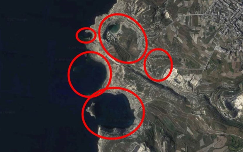
Dolines (sometimes referred to as solution subsidence structures) are important geological features of the Maltese Islands. Dolines are natural enclosed depressions in karst landscapes. They may occur as isolated individuals, as in the case of Il-Maqluba in Qrendi or in densely packed groups, as in the case of Dwejra in Gozo. They come in various shapes and can range in depth from less than a metre to hundreds of metres. Doline width varies substantially, from a few metres to more than a kilometer while their sides may range from being gently sloping to completely vertical. They have existed for a very long period of time. A substantial number lie buried beneath metres of soil and sediment while others are the mere remnants of much larger structures. Dolines are the result of a process with four main mechanisms: dissolution, collapse, suffosion and subsidence. These four main mechanisms may be result of two main geological processes. The first possibility is chemical weathering. Atmsopheric carbon dioxide dissolves in rainwater to form weak carbonic acid. As the rainwater percolates through soil, the concentration of carbonic acid builds up. Upon further percolation, this carbonic acid comes into contact with underlying limestone. The carbonic acid causes minerals in the rock to dissolve, forming caverns. The cavern roof weakens until it collapses. Its collapse forms these distinct structures. The second possibility is dissolution of evaporites. Underlying limestone may have contained a layer of gypsum or salt. As the Maltese Islands emerged from the sea, this layer may have dissolved to form caverns. Eventually, these collapsed to create the distinct hollows. Several of these subsidence structures can be found around. The satellite images of Malta and Gozo show their distribution.
The solution subsidence structures at Dwejra are the largest and most complete formation of their kind in the Maltese Islands. These are indicated by red circles on the satellite image of Dwejra. One can easily notice these by visiting the place. Dwejra is composed of circular areas. Il-Qawra, Il-Qattara, Blue Hole and Il-Port are four of these solution subsidence structures in the area. The largest of these is Il-Qawra. It is 200 metres by 500 metres wide and over 100 metres deep. The floor of the hollow is partially flooded, forming the so-called Inland Sea. Sea water entered the basin through L-Għar tad-Dwejra, This is an elongated channel enlarged by wave action that cut through the rock. The formation of the subsidence structures at Dwejra were formed millions of years ago. When the Maltese Islands emerged from the sea, the rock was exposed to weathering. Huge caverns formed. The Maltese Islands were submerged yet again. The caverns collapsed. Some time later, the Maltese Islands emerged one last time. A series of circular hollows were present instead of the caverns. The large rocks one finds in the Inland Sea are remains of the roof of the cavern. The Fungus Rock is the remains of another cavern.
The beauty of Dwejra did not end with the collapse of the Azure Window. There is so much to discover. More about the other features in a separate post!
SOILS
OF THE MALTESE ISLANDS
Soil is formed by the weathering of the parent rock. This weathering produces an aggregation of unconsolidated mineral and organic particles produced by the action of wind, water and organic decay. The formation of soils requires a stable environment and humid climates. Soils, which are quite similar to the parent rock, are also young and soil horizon development is largely inhibited by climate. Soil cover over parts of the islands is quite sparse, especially where limestone rock forms karstland with only small pockets of soil where vegetation must grow in harsh conditions.
A number of different soil types cover the Maltese Islands. All of these started to form a few thousands of years ago. They all resemble their parent bedrock. Much of the soil we find in the Maltese Islands today is referred to as soil complexes. These are soils whch have forned through human agency.
Three main types of soils exist in the Maltese Islands. They all formed thousands of years ago, when the climate was weter. The present climate regime does not encourage the formation of new soil.
The Carbonate Raw soil is a very young immature soil, with extremely low humus. Its organic matter is also very poor. At the same time, levels of calcium carbonate are very high. Soils of this kind are derived from clay deposits. As a result, it tends to become waterlogged after a wet spell.
The Xerorendzinas soil is ash grey in colour. It is also very immature with low concentrations of organic matter. Apart from this, it also has a high calcium carbonate content. It is usually very loose when dry. Soils of this kind are derived from Globigerina Limestone.
The Terra Soils are relic soils. This means they are no longer developing. They are mature and extensively weathered. They have a low calcium carbonate content. It is also rather deficient in organic matter. It owes its reddish colour to iron oxides. Terra soils develop on karstland, where Lower Coralline Limestone and Upper Corraline Limestone are exposed.
Maltese soils tend to have a suitable physical structure due to its texture and also the calcium carbonate content which decreases the risk of soil erosion but simultaneously increases the water-holding capacity and allows good drainage after a heavy rainfall. Even though organic matter is low, nutrients are kept quite well due. Soil formation under the Maltese climate and geological conditions is a very slow process and hence the amount of soil in Malta is rather low.
WATER RESOURCES
OF THE MALTESE ISLANDS
Rain is the only natural source of freshwater in the Maltese Islands. Rainwater falling over the Maltese Islands percolates through the porous rock, where it is collected. 16% to 25% of each year’s rain ends up being collected. The rest is lost at sea as run-off.
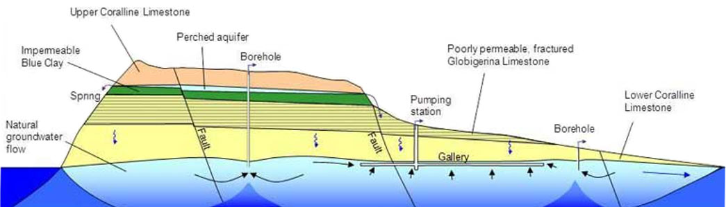
The biggest collection of freshwater in the Maltese Islands is the mean sea-level aquifer. The water here is stored in the pores of Lower Coralline Limestone and Globigerina Limestone. Seawater also penetrates this aquifer, but since the freshwater is less dense than seawater, the two of them don’t mix. Instead, the freshwater settles above the seawater.
Another collection of freshwater in the Maltese Islands is the perched aquifer. It only forms in places where the Upper Coralline Limestone, Greensands and Blue Clay lie on top of each other. Rainwater percolates easily through the Upper Coralline Limestone and Greensands, before it collects above the impermeable Blue Clay. The flow is seasonal, intermiitent and highly variable. If a perched aquifer’s flow intersects the Earth’s dry surface, at a valley wall, for example, the water is discharged as a spring.
TERRESTRIAL ECOLOGY
OF THE MALTESE ISLANDS
The terrestrial ecosystems of the Maltese Islands may be grouped in two categories; major communities and minor communities. The four major communities are part of the sequence towards the climatic climax. The minor communities are either specialised to occupy habitats which are rare in the Maltese Islands or are relics from past ecological regimes, now surviving in a few refugia.
The four major communities are the Sclerophyll Forest (Mediterranean Woodland), Maquis, Garigue and Steppic Grasland.
- Sclerophyll Forest is a typical habitat of the entire Mediterranean region and is characterized by hard leaved evergreen trees and shrubs. It is the climax of the successional vegetation series. In Malta this habitat was almost totally exterminated following the arrival of humans on the islands and, today, only few remnants are left. These few patches of woodland are usually dominated by the Evergreen Oak and are considered as being living fossils of ancient forests. The largest area is the Ballut tal-Wardija which has trees thought to be 500-900 years old. Buskett, the major part of which was planted by man, has now acquired the character of a semi-natural woodland, where the trees regenerate naturally. The dominant trees in this area are the Aleppo Pine, Evergreen Oak, Olive and Carob.
- Maquis is characterized by small trees and large shrubs. This habitat in the Maltese Islands is relatively widespread and of secondary origin whilst artificial maquis may develop into man-made groves. Maquis communities tend to grow along valley sides or at the bottom of deeper ones, on rocky slopes or beneath inland cliffs. Maquis species include the Lentisk, Bay Laurel (Rand, Laurus nobilis)
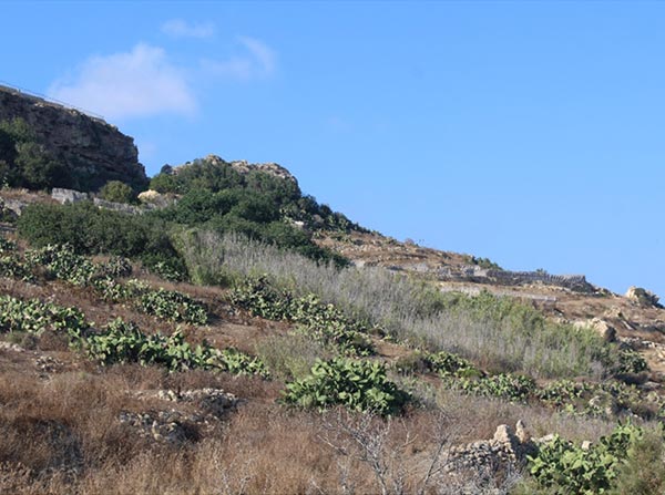
- Garigue is an ecosystem which develops on large expanses of karstic limestone landscapes. It is characterised by dense, low-lying, aromatic hardy shrubs such as the Mediterranean Thyme and the Mediterranean Heath. Natural garigue communities typically form on karstic landscapes, while others are formed as a result of degraded maquis communities. Other species of Garigue plants include Rosemary, the endemic Maltese Spurge and various orchids such as the Maltese Pyramidal Orchid.
- Steppic Grasslands are rather common throughout the islands. They usually occur either due to maquis or garigue which degraded due to a number of causes including overgrazing or fire or as natural steppic communities which are found, for instance, on clay slopes. In the latter case a natural steppe will not progress into a garigue type community as it will have reached its climax as allowed by environmental factors. Clay slope communities are often dominated by Esparto Grass, bulbous species such as the Branched and the Seaside Squill.
There are numerous secondary communities. These include rupestral communities, coastal habitats, saline marshlands, sand dunes, freshwater habitats, caves and others.
- Saline Marshlands form an interface between the marine, freshwater and terrestrial environments. The nature reserve in Għadira and Simar at the Pwales Valley are a very good example of these. The consist of a muddy substratum on which a pool of brackish water collects in the wet season. It dries up during the dry season. As a result, only specialized flora and fauna may survive.
- Sand Dunes exist at the back of some local beaches. These include Ramla l-Ħamra in Gozo and Golden Bay in Malta. Sand dune ecosystems are among the rarest and most fragile of local ecosystems. Local dunes are characterized by grasses that are adapted to withstand drought, salty conditions and total sand burial. Many of them have roots that are like threads which grow in the sand, binding it together.
- Low Lying Rocky Coasts consist of a gently sloping rocky shore with a shallow saline soil which accumulates in pockets in the rock. Rocky coastal habitats are very unstable environments since waves can wet the coast and empty the habitat. As a result, flora and fauna here vary from day to day. This environment is very similar to the Saline Marshlands and Sand Dunes.
- Rupestral Communities grow on cliff faces and high walls. The lack of water, extreme drought and severe winds make these environments the harshest of all. These areas are so difficult, that it is only colonised by specialised plants.
- Transitional Coastal Wetlands share the properties of both freshwater wetlands and saline marshlands. They also support species that are typical of both freshwater and saline habitats. An example of a permanent coastal wetland is Il-Qattara in Gozo.
- Watercourse Communities have short lifespans, as they can only survive during the wet season. The most common species of these habitats is the Painted Frog.
- Permanent Springs are not that common. The very few remaining permanent springs support a very distinctive flora and fauna. Species which require a year-round supply of running freshwater are strictly limited to this habitat. One of these species is the Mediterranean Freshwater Crab.