
Air Temperature
| Highest Maximum | 20.0°C | 28th |
| Lowest Maximum | 10.6°C | 8th |
| Highest Minimum | 14.6°C | 27th |
| Lowest Minimum | 5.1°C | 16th |
| Mean Maximum | 15.4°C |
| Mean Minimum | 8.7°C |
| Mean | 12.0°C |
Relative Humidity
| Highest Relative Humidity | 96% | Numerous days |
| Lowest Relative Humidity | 40% | 5th |
| Mean Relative Humidity | 78.9% |
Wind
| Highest Gust | 56.3km/h | 10th |
| Mean Wind Speed | 9.0km/h |
| Most Frequent Wind Direction | North Northwest |
Atmospheric Pressure
| Highest Atmospheric Pressure | 1034.0hPa | 14th |
| Lowest Atmospheric Pressure | 1000.9hPa | 26th |
| Mean Atmospheric Pressure | 1022.8hPa |
Precipitation
| Total Rainfall During February 2023 | 149.4 mm |
| Total Rainfall Since Last 01/09 | 506.5 mm |
| Highest 24 Hour Total | 121.1 mm | 9th |
| Rain Days | 7 days |
| Thunderstorm Days | 2 days |
| Hail Days | 1 day |
Rainfall Events
| 02/02/2023 | 1.1 mm | Light Rain |
| 07/02/2023 | 3.0 mm | Light Rain |
| 08/02/2023 | 18.7 mm | P.M. Steady Rain |
| 09/02/2023 | 121.1 mm | Steady Rain; Thunderstorms |
| 10/02/2023 | 2.5 mm | A.M. Steady Rain; Distant Thunder and Hail |
| 13/02/2023 | 1.5 mm | Light Rain |
| 14/02/2023 | 0.5 mm | Light Rain |
| 21/02/2023 | 0.3 mm | Dew; Fog |
| 22/02/2023 | 0.2 mm | Dew; Fog |
| 23/02/2023 | 0.3 mm | Dew; Fog |
| 24/02/2023 | 0.2 mm | Dew; Fog |
February 2023 Compared to the Climate Means
| Climate Mean | February 2023 | Anomaly | |
| Mean Maximum Temperature | 15.6°C | 15.4°C | -0.2°C |
| Mean Minimum Temperature | 9.7°C | 8.7°C | -1.0°C |
| Mean Temperature | 12.7°C | 12.0°C | -0.7°C |
| Mean Relative Humidity | 78.1% | 78.9% | +0.8% |
| Mean Atmospheric Pressure | 1019.6hPa | 1022.8hPa | +3.2hPa |
| Total Rainfall | 59.5 mm | 149.4 mm | +89.9 mm |
| Total Rainfall Since Last 01/09 | 495.9 mm | 506.5 mm | +10.6 mm |
| Total Rain Days | 11 days | 7 days | -4 days |
| Total Thunderstorm Days | 3 days | 2 days | -1 day |
| Total Hail Days | 2 days | 1 day | -1 day |
An Eventful FEBRUARY 2023
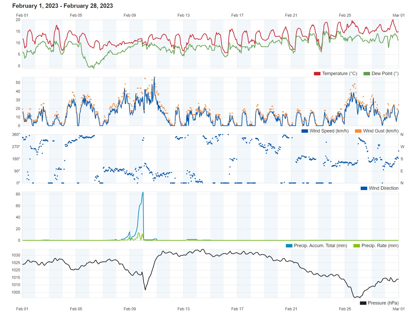
The third and final month of the 2022/2023 meteorological winter proved to be a very eventful one.
149.4 mm of rain were measured over the course of last February. 95% of this were measured in a staggering 35 hours of incessant rainfall from later in the afternoon on the 8th through to the predawn hours of the 10th. The 9th will be remembered for being the wettest February day on record. This was produced by Storm Helios, an intense Mediterranean cyclone which developed over the central Mediterranean. These 35 hours of intense rainfall also accounted for the two days of thunder and one day of hail recorded last month. The rest of the month was relatively stable.
February 2023 was colder than average overall. Whilst the mean maximum temperature of 15.4°C was only marginally below the climate norm, the mean minimum temperature of 8.7°C was a full degree colder than normal. February’s mean temperature of 12.0°C was 0.7°C lower than the typical value for the time of year. Most nights were colder than average. This could be due to the anticyclonic conditions that maintained clear skies and calm winds overnight, allowing for the cooling of the air. The mercury dipped to its coldest point in the early hours of the 16th, when a chilly 5.1°C was measured. The only exception to the fresh conditions that dominated much of February was the month’s closing week. A current of warm, humid air off the Sahara Desert, formed by the passage of a zone of low pressure across our area. The final day of February 2023 was to be the month’s warmest. The temperature on the 28th shot up to 20°C.
Rounding off the month with a mean of 1022.8hPa, atmospheric pressure was significantly higher than norm. This had a profound impact on the sea-level around the Maltese Islands. The atmospheric pressure shot up from 1005.7hPa (stormy weather) on Friday 10th February to 1032.7hPa (fine weather) on Saturday 11th February. It remained at consistently high levels for a number of days, with the highest values peaking at 1034hPa on the 14th. This spike in atmospheric pressure increased the force the air exerted on the sea. On average, a column of air with a cross-sectional area of 1 square centimeter squared, measured from the sea level to the top of the Earth’s atmosphere, has a mass of approximately 1 kilogram. A 1hPa increase in atmospheric pressure on a regional level temporarily lowers the sea-level by approximately 1 centimeter. When this phenomenon happens on a regional the fall in sea-level is significant. In fact, the temporary fall in sea-level last month was one of the most drastic in recent years.
In the morning of the 23rd, people across the Maltese Islands woke up to widespread fog. This persisted for a long while and caused some delays to flights at the airport. That morning’s fog, termed radiation fog in meteorology, was a product of the great stability the Maltese Islands were experiencing at that point. Radiation fog is formed by the cooling of land after sunset by infrared thermal radiation in calm conditions with a clear sky. The cooling ground cools adjacent air by conduction, causing the air temperature to fall and reach the dew point (the temperature at which an air mass becomes saturated and the water vapor in it condenses), forming fog. Radiation fog occurs at night, and often does not last long after sunrise. That morning’s fog was denser and more persistent than usual for one reason. The land was still wet from the abundant precipitation received from Storm Helios earlier on in February. The moisture available for the formation of fog was far more plentiful than in a typical year.
Rainfall Totals around the Maltese Islands in February 2023 (and since last September 1st):
Għarb: 149.4 mm (506.5 mm)
Victoria: 142.2 mm (450.6 mm)
Xewkija: 126.0 mm (444.4 mm)
Nadur: 139.6 mm (438.2 mm)
Marsalforn: 143.9 mm (467.4 mm)
Mellieħa: 134.7 mm (414.1 mm)
Buġibba: 153.2 mm (494.7 mm)
Mġarr: 129.5 mm (443.4 mm)
Naxxar: 179.0 mm (583.9 mm)
Mosta: 170.1 mm (556.3 mm)
Dingli: 145.2 mm (470.6 mm)
Msida: 202.6 mm (655.0 mm)
Valletta: 133.8 mm (478.1 mm)
Imqabba: 172.2 mm (528.9 mm)
Żabbar: 172.5 mm (535.3 mm)
Birżebbuġa: 151.7 mm (438.0 mm)
Sliema: 167.9 mm (617.9 mm)
NATIONAL MEAN: 153.7 mm (501.3 mm)