June 2026 Delivers Heat, Sunshine and Dryness
Air Temperature
| Highest Maximum | 34.7°C | 29th |
| Lowest Maximum | 26.0°C | 12th |
| Highest Minimum | 25.3°C | 29th |
| Lowest Minimum | 18.4°C | 15th |
| Mean Maximum | 29.6°C |
| Mean Minimum | 21.4°C |
| Mean | 25.5°C |
Relative Humidity
| Highest Relative Humidity | 91% | Numerous days |
| Lowest Relative Humidity | 35% | 20th |
| Mean Relative Humidity | 76.2% |
Wind
| Highest Gust | 41.8km/h | 12th |
| Days with Force 5 (29 – 38kph) | 1 day |
| Days with Force 6 (39 – 49kph) | 1 day |
| Days with Force 7 (50 – 61kph) | 0 days |
| Days with Force 8 (62 – 74kph) | 0 days |
| Days with Force 9 (75 – 88kph) | 0 days |
| Days with Force 10+ (89kph+) | 0 days |
| Mean Wind Speed | 6.8km/h |
| Most Frequent Wind Direction | South |
Atmospheric Pressure
| Highest Atmospheric Pressure | 1023.4hPa | 21st |
| Lowest Atmospheric Pressure | 1012.0hPa | 5th |
| Mean Atmospheric Pressure | 1017.3hPa |
Precipitation
| Total Rainfall During June2026 | 0.0 mm |
| Total Rainfall Since Last 01/09 | 545.5 mm |
| Highest 24 Hour Total | / | / |
| Rain Days | 0 days |
| Thunderstorm Days | 0 days |
| Hail Days | 0 days |
Rainfall Events
| 08/06/2026 | TR mm | Distant Isolated Light Rain |
June 2026 Compared to the Climate Means
| Climate Mean | June2026 | Anomaly | |
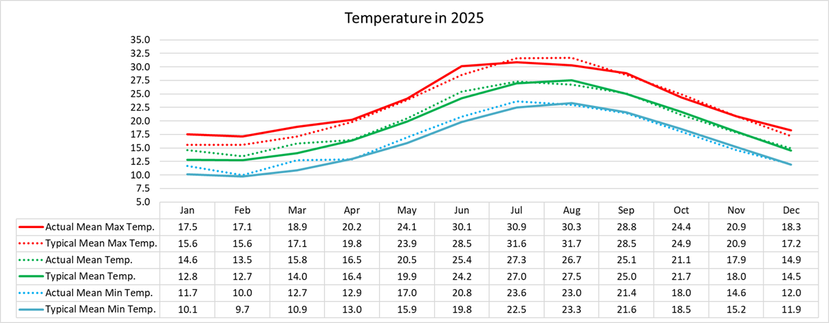
| Mean Maximum Temperature | 28.5°C | 29.6°C | +1.1°C |
| Mean Minimum Temperature | 19.8°C | 21.4°C | +1.6°C |
| Mean Temperature | 24.2°C | 25.5°C | +1.3°C |
| Mean Relative Humidity | 70.5% | 76.2% | +1.7% |
| Mean Atmospheric Pressure | 1015.1hPa | 1017.3hPa | +2.2hPa |
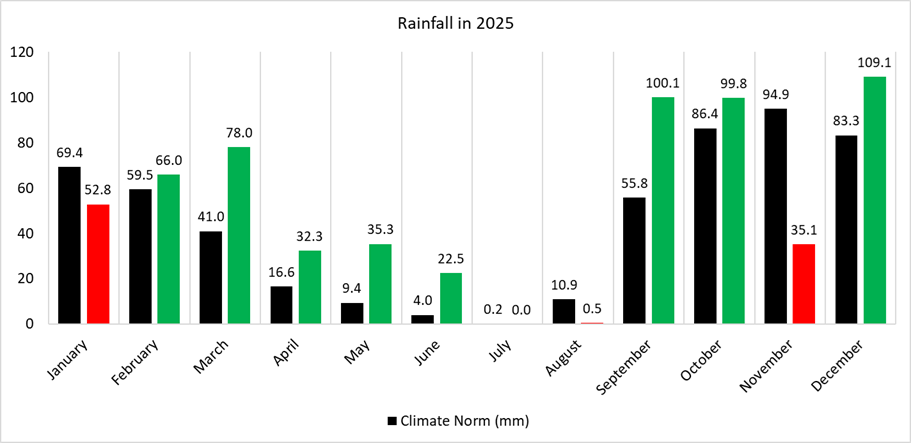
| Total Rainfall | 4.1 mm | 0.0 mm | -4.1 mm |
| Total Rainfall Since Last 01/09 | 523.9 mm | 545.5 mm | +21.6 mm |
| Total Rain Days | 1 day | 0 days | -1 day |
| Total Thunderstorm Days | 1 day | 0 days | -1 day |
| Total Hail Days | 0 days | 0 days | / |
June 2026 Delivers Heat, Sunshine and Dryness
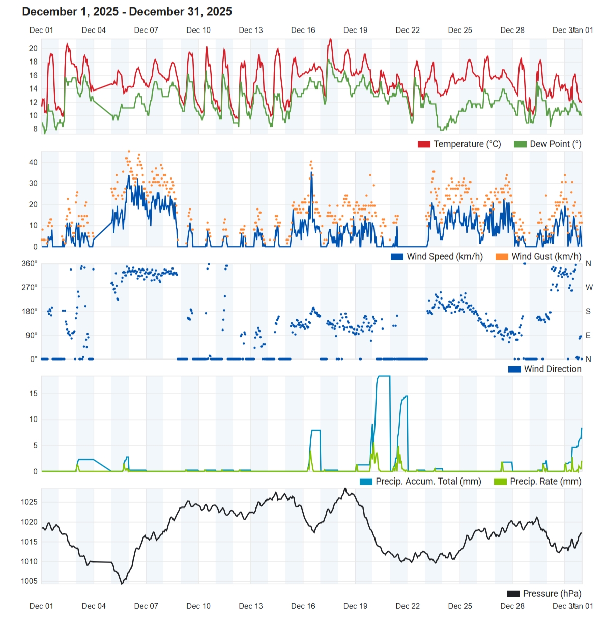
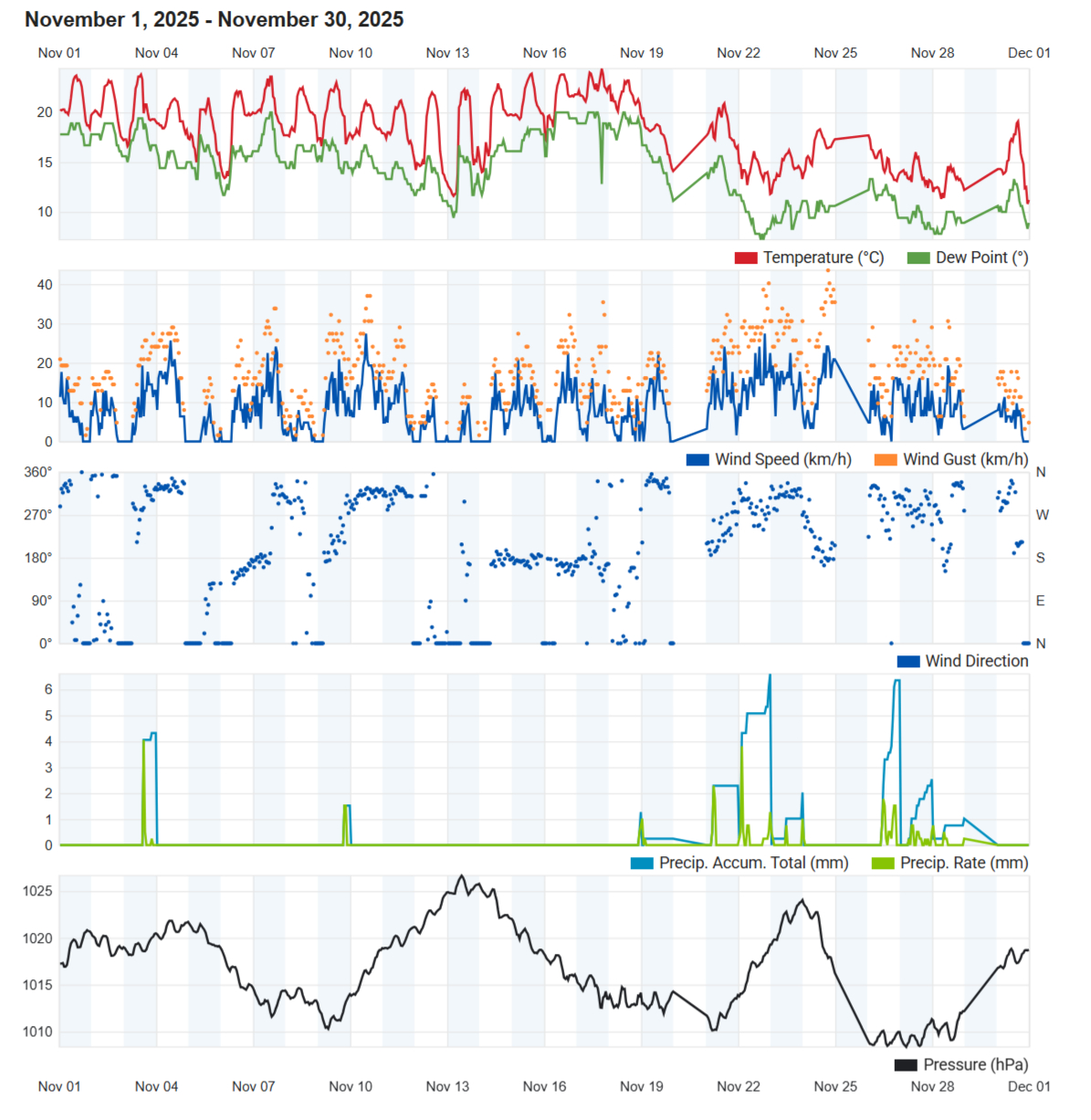
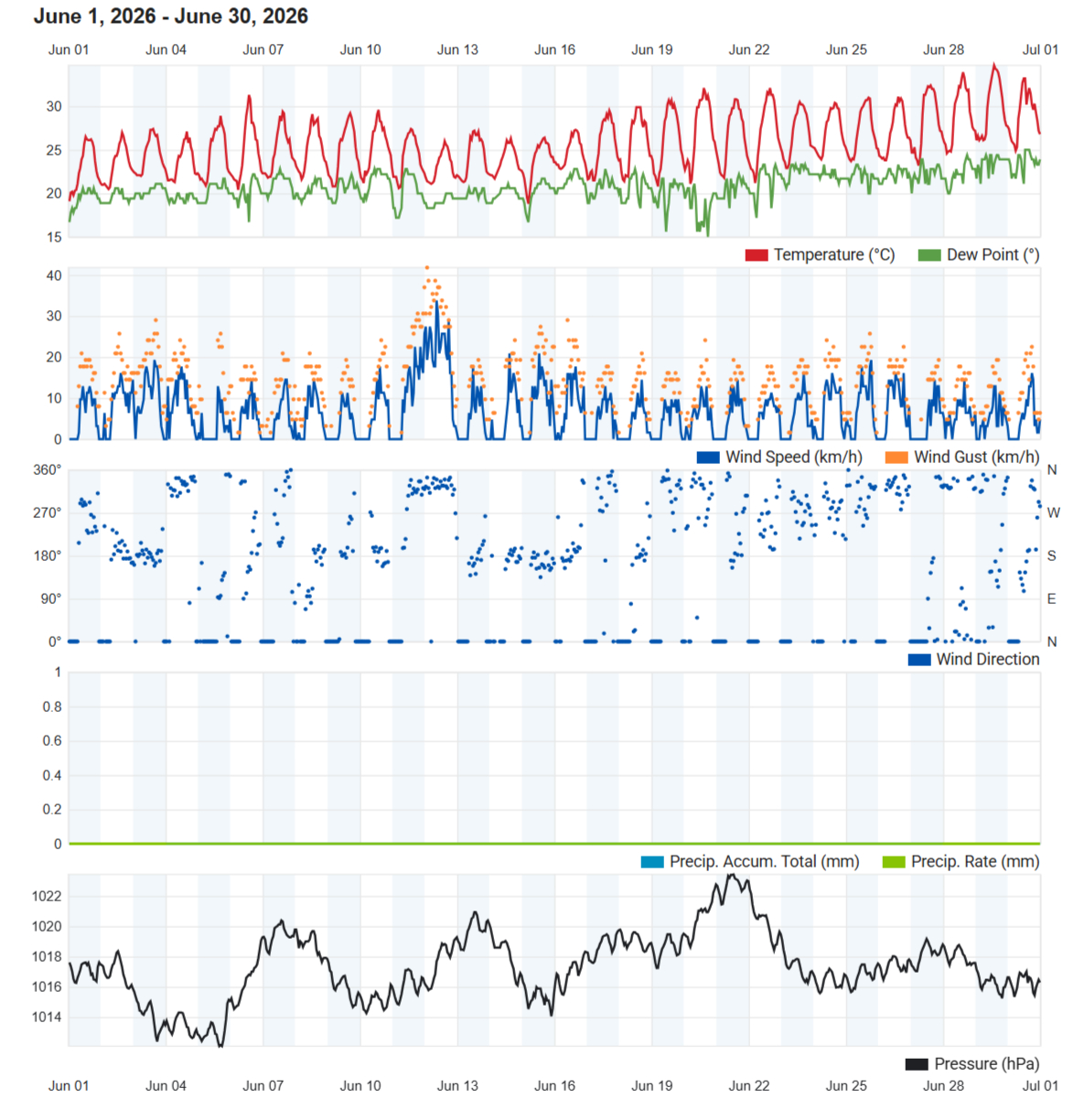
June 2026 marked the decisive arrival of the Mediterranean summer, with persistent warmth, abundant sunshine and the complete absence of measurable rainfall. Dominated by stable high pressure, light winds and increasingly humid nights, the month exhibited all the hallmarks of the region’s dry season while continuing the year’s trend of above-average temperatures.
The mean air temperature reached 25.5°C, making June 1.3°C warmer than the climatological average. Both daytime and night-time temperatures contributed to this anomaly, with the mean maximum reaching 29.6°C (+1.1°C) and the mean minimum 21.4°C (+1.6°C). The larger positive anomaly in minimum temperatures reflects increasingly warm nights, characteristic of the growing influence of a warming Mediterranean Sea and persistent humid air masses. The hottest day of the month occurred on the 29th, when the temperature climbed to 34.7°C, accompanied by the highest minimum of the month (25.3°C), providing the first significant heat episode of the summer. The coolest day was recorded on the 12th with a maximum of 26.0°C, while the lowest minimum of 18.4°C occurred on the 15th. Both were the highest in a number of years.
Relative humidity averaged 76.2%, remaining above the long-term mean despite the complete absence of rainfall. Although humidity dropped to 35% on the 20th under particularly dry daytime conditions, overnight humidity frequently exceeded 90%, illustrating the increasing maritime influence typical of early summer.
Atmospheric pressure averaged 1017.3 hPa, 2.2 hPa above normal, confirming that anticyclonic conditions had become firmly established across the central Mediterranean. Pressure fluctuated within a relatively narrow range between 1012.0 hPa on the 5th and 1023.4 hPa on the 21st, indicative of a stable synoptic pattern with little influence from significant low-pressure systems.
Wind conditions became noticeably lighter than during the preceding months. Mean wind speed fell to just 6.8 km/h, the lowest recorded so far in 2026, while southerly winds were the most frequent direction. Only one day reached Force 5 and one day Force 6, with the month’s strongest gust peaking at 41.8 km/h on the 12th. The prevalence of light southerly airflow likely contributed to both the elevated temperatures and the increasingly warm nights observed throughout the month.
Perhaps the defining characteristic of June was its complete absence of measurable rainfall. No precipitation was recorded at the Kerċem weather station, compared to the climatological average of 4.1 mm. Although distant light rain was observed on the 8th, none reached the station, resulting in zero rain days, zero thunderstorm days and zero hail days. Such conditions are entirely consistent with the establishment of the Mediterranean summer drought, during which the subtropical ridge suppresses cloud development and frontal systems are displaced well to the north of the islands.
Despite the exceptionally dry month, cumulative rainfall since 1 September remained at 545.5 mm, preserving a 21.6 mm surplus over the long-term seasonal average. This surplus was entirely attributable to the exceptionally wet conditions experienced earlier in the hydrological year, particularly during January.
Rainfall Totals around the Maltese Islands in June2026 (and since last September 1st):
Kerċem: 0.0 mm (545.5 mm)
Victoria: 0.0 mm (547.3 mm)
Marsalforn: 0.0 mm (494.3 mm)
Xewkija: 0.0 mm (470.3 mm)
Nadur: 0.0 mm (496.1 mm)
Għajnsielem: 0.0 mm (500.9 mm)
Mellieħa: 0.0 mm (367.5 mm)
Buġibba: 0.0 mm (356.9 mm)
Mġarr: 0.0 mm (502.7 mm)
Naxxar: 0.0 mm (427.7 mm)
Mosta: 0.0 mm (392.6 mm)
Dingli: 0.0 mm (544.7 mm)
Pembroke: 0.0 mm (433.9 mm)
Msida: 0.0 mm (456.1 mm)
Sliema: 0.0 mm (449.6 mm)
Valletta: 0.0 mm (406.0 mm)
Fgura: 0.0 mm (462.7 mm)
Żejtun: 0.0 mm (411.3 mm)
Żabbar: 0.0 mm (381.2 mm)
Imqabba: 0.0 mm (546.6 mm)
Siġġiewi: 0.0 mm (535.8 mm)
Żurrieq: 0.0 mm (543.3 mm)
Marsaxlokk: 0.0 mm (379.2 mm)
NATIONAL MEAN: 0.0 mm (461.2 mm)