Wetter in Gozo but Drier in Malta in September 2025
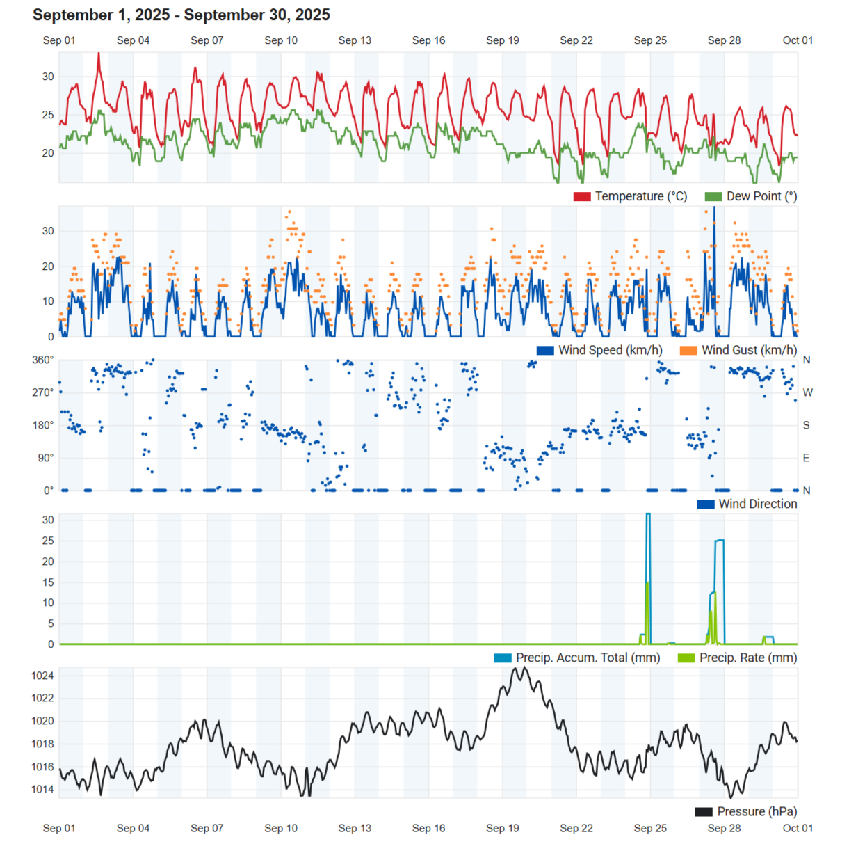
Air Temperature
| Highest Maximum | 33.1°C | 2nd |
| Lowest Maximum | 25.1°C | 27th |
| Highest Minimum | 25.8°C | 10th |
| Lowest Minimum | 17.7°C | 30th |
| Mean Maximum | 28.8°C |
| Mean Minimum | 21.4°C |
| Mean | 25.1°C |
Relative Humidity
| Highest Relative Humidity | 96% | Numerous days |
| Lowest Relative Humidity | 55% | 2nd and 25th |
| Mean Relative Humidity | 79.0% |
Wind
| Highest Gust | 35.4km/h | 10th |
| Mean Wind Speed | 7.3km/h |
| Most Frequent Wind Direction | South |
Atmospheric Pressure
| Highest Atmospheric Pressure | 1024.7hPa | 19th |
| Lowest Atmospheric Pressure | 1012.4hPa | 11th |
| Mean Atmospheric Pressure | 1017.6hPa |
Precipitation
| Total Rainfall During September 2025 | 100.1 mm |
| Total Rainfall Since Last 01/09 | 100.1 mm |
| Highest 24 Hour Total | 60.4 mm | 24th |
| Rain Days | 3 days |
| Thunderstorm Days | 3 days |
| Hail Days | 1 day |
Rainfall Events
| 24/09/2025 | 60.4 mm | Afternoon Isolated Thunderstorm; Evening Thunderstorm |
| 26/09/2025 | 0.0 mm | Distant Isolated Light Rain; Distant Thunder |
| 27/09/2025 | 37.1 mm | Morning Thunderstorm; Afternoon Thunderstorm with Hail |
| 29/09/2025 | 2.6 mm | Afternoon Isolated Shower |
September 2025 Compared to the Climate Means
| Climate Mean | September 2025 | Anomaly | |
| Mean Maximum Temperature | 28.5°C | 28.8°C | +0.3°C |
| Mean Minimum Temperature | 21.6°C | 21.4°C | -0.2°C |
| Mean Temperature | 25.0°C | 25.1°C | +0.1°C |
| Mean Relative Humidity | 76.6% | 79.0% | +2.4% |
| Mean Atmospheric Pressure | 1016.7hPa | 1017.6hPa | +0.9hPa |
| Total Rainfall | 54.9 mm | 100.1 mm | +45.2 mm |
| Total Rainfall Since Last 01/09 | 54.9 mm | 100.1 mm | +45.2 mm |
| Total Rain Days | 5 days | 3 days | -2 days |
| Total Thunderstorm Days | 3 days | 3 days | / |
| Total Hail Days | 0 days | 1 day | +1 day |
Wetter in Gozo but Drier in Malta in September 2025
Temperatures in the first month of meteorological autumn were around average for the time of year. The mean temperature of 25.1°C was only a fraction of a degree above average. The slightly warmer days but slightly cooler nights contributed to this balance. The warmest day of the month, the 2nd, registered a maximum temperature 33.1°C. Temperatures declined gradually as the month progressed. Levels of relative humidity were overall higher than the norm, meaning realfeels were generally higher than the actual temperatures.
Precipitation patterns weren’t as straightforward. Last month was completely dry up until the 23rd. The first wave of autumn instability arrived late and lasted for much of the final week of September 2025. The 24th and the 27th were particularly stormy; producing 97.5 mm of the 100.1 mm measured at our Gozo weather station. Whilst Gozo experienced flash flooding in the usual localities on both days, Malta was left largely untouched by the heavy downpours on those days. Mean precipitation across Malta totalled 15.5 mm. This was very poor when compared to Gozo’s average of 103 mm. There were three rainy days. Thunder was heard on three days. Hail accompanied the afternoon thunderstorm on the 27th. The thunderstorm on the 27th brought a so-called ‘microburst’ (sudden torrential rain accompanied by strong wind) to localities across the southern half of Gozo.
September was marked by a notable absence of windy days, probably due to the intense high pressure which prevailed across the central Mediterranean for much of the month.
Rainfall Totals around the Maltese Islands in September 2025 (and since last September 1st):
Kerċem: 100.1 mm (100.1 mm)
Victoria: 107.3 mm (107.3 mm)
Marsalforn: 84.2 mm (84.2 mm)
Xewkija: 115.4 mm (115.4 mm)
Nadur: 105.2 mm (105.2 mm)
Għajnsielem: 105.9 mm (105.9 mm)
Mellieħa: 20.4 mm (20.4 mm)
Buġibba: 15.7 mm (15.7 mm)
Mġarr: 6.6 mm (6.6 mm)
Naxxar: 17.9 mm (17.9 mm)
Mosta: 14.0 mm (14.0 mm)
Dingli: 11.4 mm (11.4 mm)
Pembroke: 28.5 mm (28.5 mm)
Msida: 24.6 mm (24.6 mm)
Sliema: 29.8 mm (29,8 mm)
Valletta: 33.7 mm (33.7 mm)
Fgura: 3.3 mm (3.3 mm)
Żejtun: 9.9 mm (9.9 mm)
Żabbar: 10.8 mm (10.8 mm)
Imqabba: 8.5 mm (8.5 mm)
Siġġiewi: 10.0 mm (10.0 mm)
Żurrieq: 10.9 mm (10.9 mm)
Marsaxlokk: 8.2 mm (8.2 mm)
NATIONAL MEAN: 40.5 mm (40.5 mm)