2024: Dominated by Drier and Warmer than Average Weather
Air Temperature
| Highest Maximum | 36.2°C | 19th July 2024 |
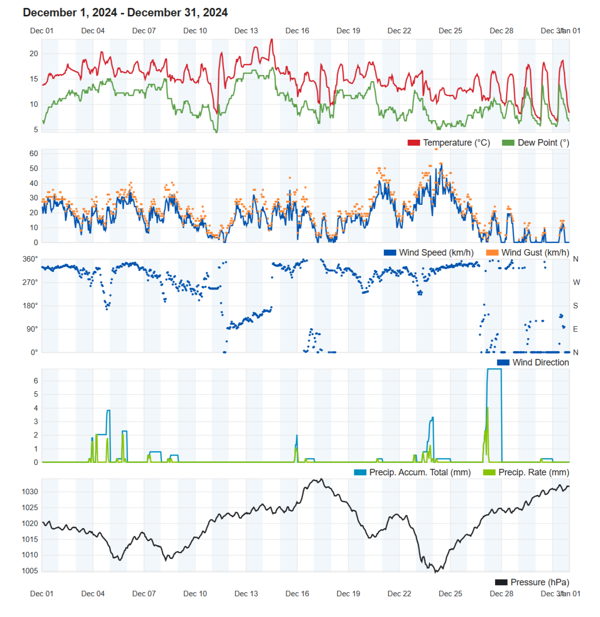
| Lowest Maximum | 13.2°C | 24th + 25th December 2024 |
| Highest Minimum | 26.9°C | 4th September 2024 |
| Lowest Minimum | 5.2°C | 23rd January 2024 |
| Mean Maximum | 23.6°C |
| Mean Minimum | 16.7°C |
| Mean | 20.1°C |
Relative Humidity
| Mean Relative Humidity | 77.8% |
Atmospheric Pressure
| Highest Atmospheric Pressure | 1035.1hPa | 24th November 2024 |
| Lowest Atmospheric Pressure | 999.2hPa | 27th March 2024 |
| Mean Atmospheric Pressure | 1016.8hPa |
Wind
| Highest Gust | 62.8 km/h (Force 8) | 24th December 2024 |
| Mean Wind Speed | 10.3 km/h |
| Most Frequent Wind Direction | Northwest |
Precipitation
| Total Rainfall During 2024 | 366.5 mm |
| Highest 24 Hour Total | 33.1 mm | 11th November 2024 |
| Rain Days | 69 days |
| Thunderstorm Days | 25 days |
| Hail Days | 10 days |
Rainfall Events
| 06/01/2024 | 10.3 mm | Thundery Showers with Hail |
| 07/01/2024 | 3.6 mm | Showers |
| 08/01/2024 | 4.2 mm | Showers |
| 09/01/2024 | 1.5 mm | Light Rain |
| 10/01/2024 | 4.6 mm | Showers |
| 12/01/2024 | 25.3 mm | Thundery Showers |
| 16/01/2024 | 1.2 mm | Light Rain |
| 20/01/2024 | 2.0 mm | Light Rain |
| 21/01/2024 | 2.3 mm | Light Rain |
| 23/01/2024 | 0.0 mm | Distant Light Rain |
| 02/02/2024 | 0.3 mm | P.M. Light Rain |
| 03/02/2024 | 0.3 mm | A.M. Light Rain |
| 11/02/2024 | 0.3 mm | Light Rain; Hailstorm in Malta |
| 12/02/2024 | 0.2 mm | Light Rain |
| 13/02/2024 | 0.3 mm | Light Rain |
| 20/02/2024 | 0.8 mm | Light Rain |
| 21/02/2024 | 21.4 mm | A.M. Rainy; Isolated Showers |
| 25/02/2024 | 23.3 mm | A.M. Rain; Thunderstorms |
| 29/02/2024 | 3.3 mm | Thunderstorm; Localised Hail |
| 01/03/2024 | 7.5 mm | Showers with Hail |
| 02/03/2024 | 0.0 mm | Distant Showers |
| 04/03/2024 | 3.3 mm | Showers |
| 05/03/2024 | 0.0 mm | Distant Showers |
| 11/03/2024 | 0.0 mm | Haze |
| 19/03/2024 | 0.0 mm | Dense Fog |
| 22/03/2024 | 0.0 mm | Dense Fog |
| 26/03/2024 | 0.5 mm | Light Rain; Widespread Dust |
| 27/03/2024 | 0.0 mm | Widespread Dust |
| 28/03/2024 | 0.0 mm | Widespread Dust |
| 29/03/2024 | 0.0 mm | Widespread Dust |
| 09/04/2024 | 0.0 mm | Mist |
| 16/04/2024 | 0.3 mm | Light Rain; Distant Thunderstorm |
| 19/04/2024 | 0.5 mm | Light Rain |
| 24/04/2024 | 10.4 mm | Steady Light/Moderate Rain |
| 01/05/2024 | 3.3 mm | Thunderstorm |
| 08/05/2024 | 8.5 mm | Rainy |
| 09/05/2024 | 0.5 mm | Light Rain |
| 11/05/2024 | 0.0 mm | Haze |
| 15/05/2024 | TR mm | Drops of Rain |
| 16/05/2024 | TR mm | Drops of Rain |
| 17/05/2024 | TR mm | Drops of Rain |
| 19/05/2024 | 1.4 mm | Light Thunderstorm |
| 20/05/2024 | 0.0 mm | Haze; Widespread Dust |
| 21/05/2024 | 0.0 mm | Haze; Widespread Dust |
| 04/06/2024 | 0.5 mm | A.M. Light Thunderstorm; Light Rain |
| 05/06/2024 | 0.3 mm | A.M. Light Rain; Distant Thunderstorm |
| 08/06/2024 | 0.3 mm | A.M. Light Rain |
| 08/07/2024 | 0.0 mm | Mist |
| 14/07/2024 | 0.0 mm | Fog |
| 29/07/2024 | 0.0 mm | Mist |
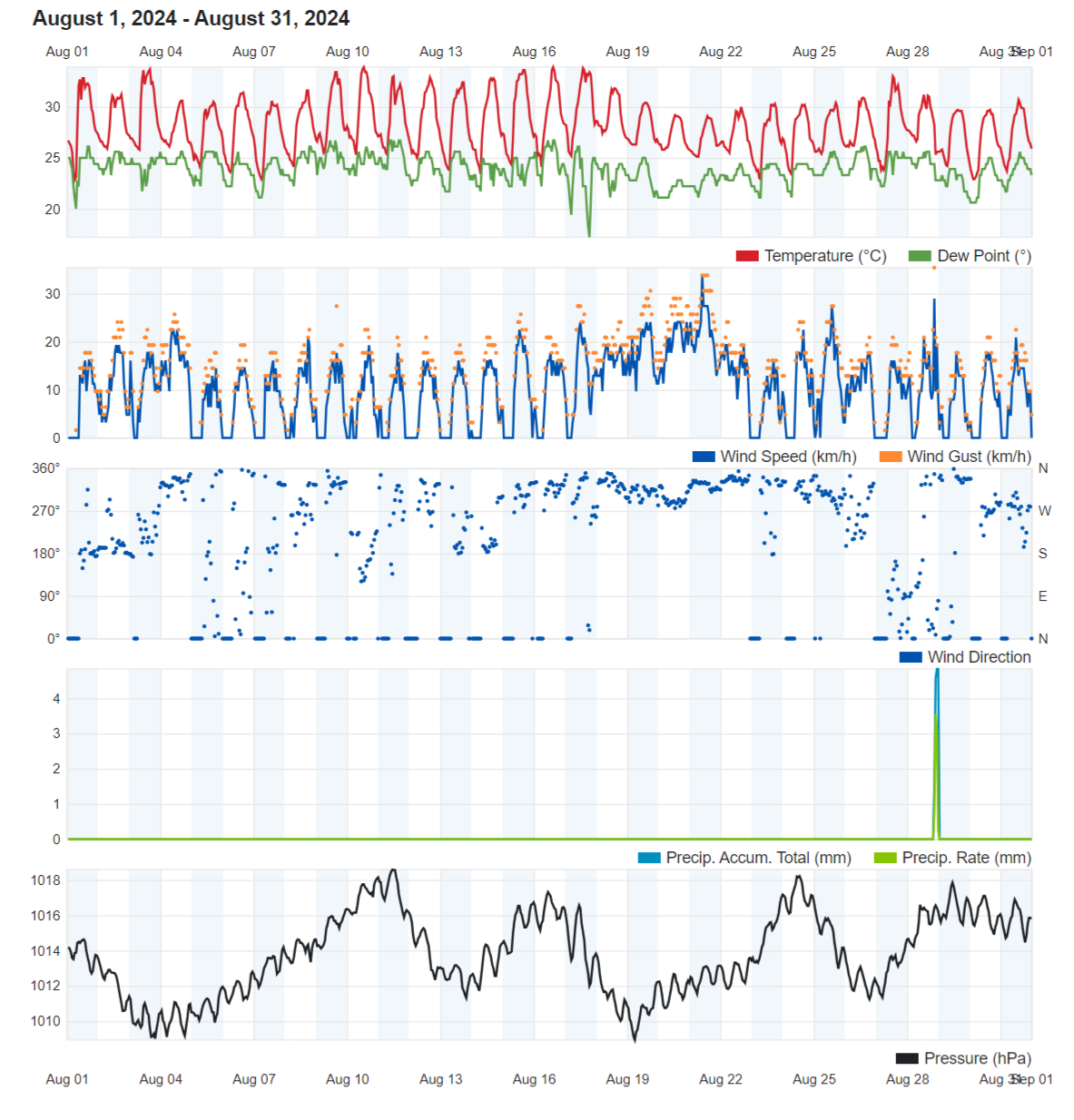
| 22/08/2024 | 0.0 mm | Għarixa; Distant Showers |
| 28/08/2024 | 6.6 mm | Isolated Thunderstorms with Hail; P.M. Thunderstorm |
| 29/08/2024 | 0.0 mm | Distant A.M. Showers |
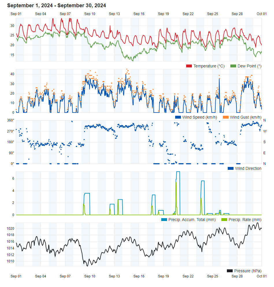
| 09/09/2024 | 3.8 mm | Isolated Showers |
| 13/09/2024 | 2.5 mm | Light Rain |
| 17/09/2024 | 4.0 mm | Light Ran |
| 18/09/2024 | 0.8 mm | Light Rain; Distant Thunder |
| 19/09/2024 | 0.0 mm | Distant P.M. Downpour |
| 20/09/2024 | 9.1 mm | Showers; Distant Thunderstorm with Hail |
| 21/09/2024 | 0.5 mm | Light Rain |
| 23/09/2024 | 7.6 mm | Showers |
| 24/09/2024 | 0.3 mm | Light Rain |
| 25/09/2024 | 0.8 mm | Light Rain |
| 26/09/2024 | 0.3 mm | Light Rain |
| 18/10/2024 | 0.5 mm | Light Rain Shower |
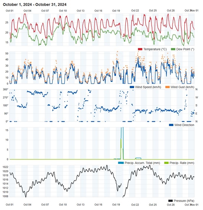
| 19/10/2024 | 22.4 mm | Thunderstorm |
| 22/10/2024 | 1.0 mm | Light Rain Shower; Distant Thunderstorm |
| 06/11/2024 | 0.0 mm | Distant Localized Shower |
| 07/11/2024 | 0.5 mm | A.M. Light Rain; Distant P.M. Steady Rain |
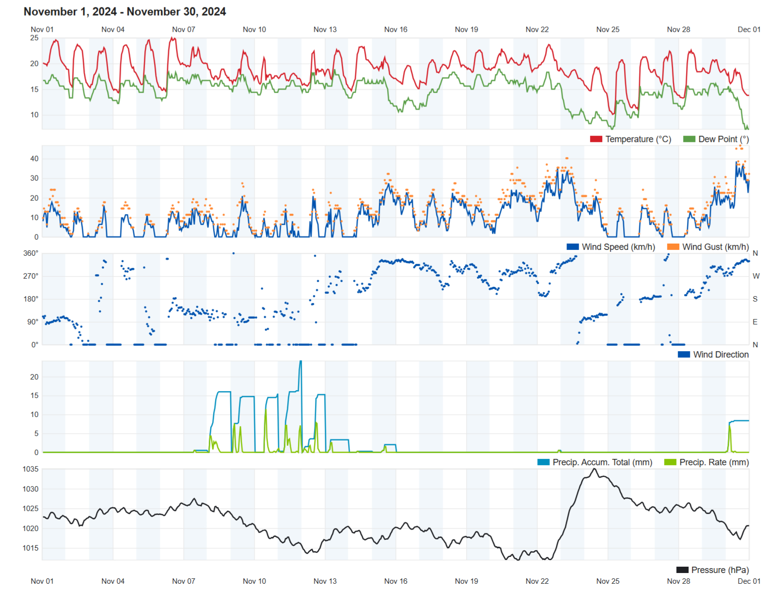
| 08/11/2024 | 20.3 mm | A.M. Steady Rain; Isolated Thunderstorms |
| 09/11/2024 | 20.5 mm | A.M. Heavy Rain Showers |
| 10/11/2024 | 18.3 mm | Heavy Rain Showers; Isolated Thunderstorms |
| 11/11/2024 | 33.1 mm | Heavy Rain; Isolated Thunderstorms |
| 12/11/2024 | 22.2 mm | Heavy Rain Showers; Isolated Thunderstorms |
| 13/11/2024 | 3.3 mm | A.M. Isolated Showers |
| 15/11/2024 | 2.6 mm | A.M. Isolated Thunderstorms |
| 21/11/2024 | 0.0 mm | Distant Isolated Showers |
| 27/11/2024 | 0.2 mm | Isolated Light Rain; Distant Isolated Showers |
| 29/11/2024 | 0.0 mm | Distant P.M. Isolated Showers |
| 30/11/2024 | 10.3 mm | Showers; Distant Isolated Thunderstorms |
| 01/12/2024 | TR mm | Isolated Light Rain |
| 03/12/2024 | 1.8 mm | P.M. Isolated Thunderstorm |
| 04/12/2024 | 5.9 mm | A.M. and P.M. Isolated Thunderstorm |
| 05/12/2024 | 3.4 mm | Isolated Showers; Distant A.M. and P.M. Hailstorms |
| 06/12/2024 | 0.0 mm | Distant Isolated Showers |
| 07/12/2024 | 0.8 mm | Isolated Light Rain; Distant Isolated Showers |
| 08/12/2024 | 0.5 mm | Isolated Light Rain; Distant Isolated Showers |
| 15/12/2024 | 3.9 mm | P.M. Rain/Hail Showers; Distant Thunder |
| 16/12/2024 | 0.5 mm | A.M. Light Rain; Distant Thundery Rain/Hail Showers |
| 20/12/2024 | 0.3 mm | Isolated Showers |
| 21/12/2024 | 0.2 mm | Isolated Showers |
| 22/12/2024 | 0.5 mm | Isolated Showers |
| 23/12/2024 | 3.3 mm | Isolated Showers with Hail; Distant Hailstorms and Thunder |
| 24/12/2024 | 0.3 mm | Light Rain; Distant Isolated Showers |
| 25/12/2024 | 0.0 mm | Distant P.M. Isolated Showers |
| 26/12/2024 | 1.9 mm | P.M. Isolated Showers |
| 27/12/2024 | 8.5 mm | A.M. Isolated Showers |
| 28/12/2024 | 0.0 mm | Distant Light Rain |
| 30/12/2024 | TR mm | Dew |
2024 Compared to the Climate Means
| Climate Mean | 2024 | Anomaly | |
| Mean Maximum Temperature | 22.9°C | 23.6°C | +0.7°C |
| Mean Minimum Temperature | 16.0°C | 16.7°C | +0.7°C |
| Mean Temperature | 19.5°C | 20.2°C | +0.7°C |
| Mean Relative Humidity | 75.7% | 77.8% | +2.1% |
| Mean Atmospheric Pressure | 1016.5hPa | 1016.8hPa | +0.3hPa |
| Mean Wind Speed | 14.1 km/h | 10.3 km/h | -3.8 km/h |
| Most Frequent Wind Direction | West Northwest | Northwest | +22.5° |
| Total Rainfall | 531.4 mm | 366.5 mm | -164.9 mm |
| Total Rain Days | 84 days | 69 days | -15 days |
| Total Thunderstorm Days | 30 days | 25 days | -5 days |
| Total Hail Days | 10 days | 10 days | / |
Month-by-Month Summary for 2024
January 2024 – Warmer and Drier
February 2024 – Warmer and Drier
March 2024 – Warmer and Drier
April 2024 – Warmer and Drier
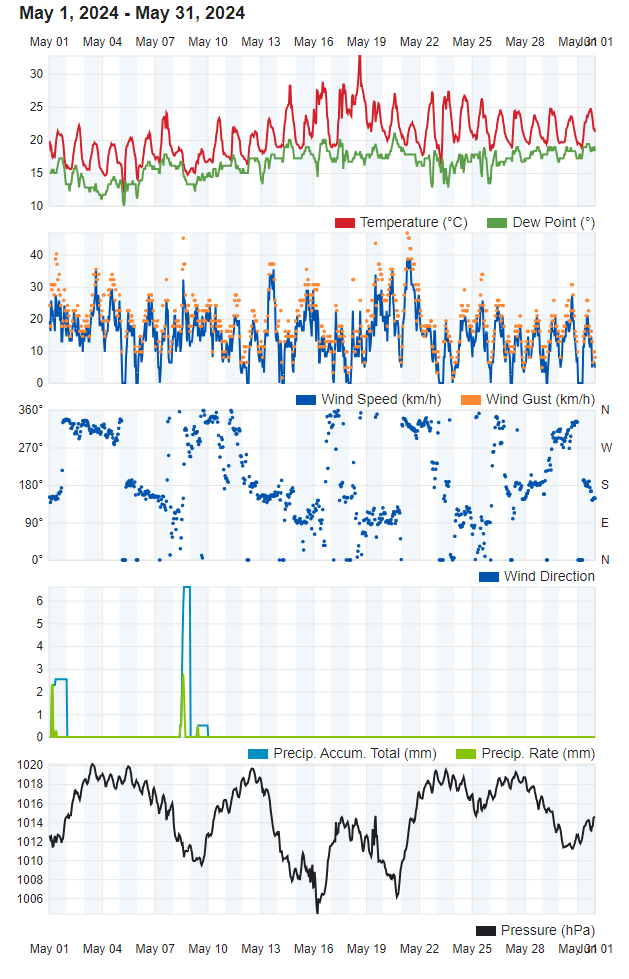
May 2024 – Warmer and Wetter
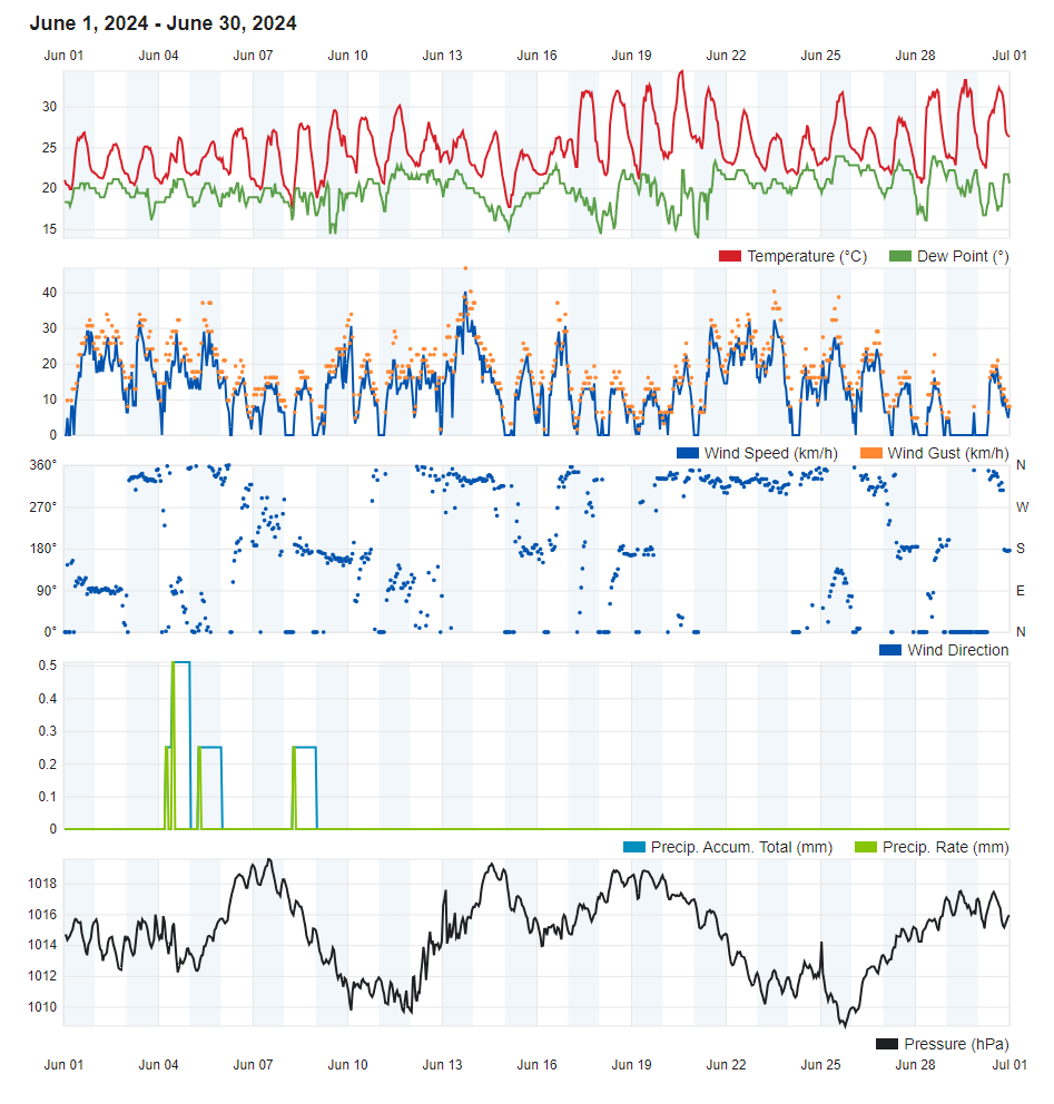
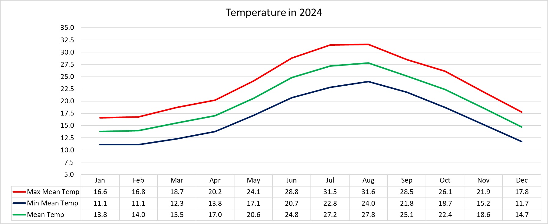
June 2024 – Colder and Drier
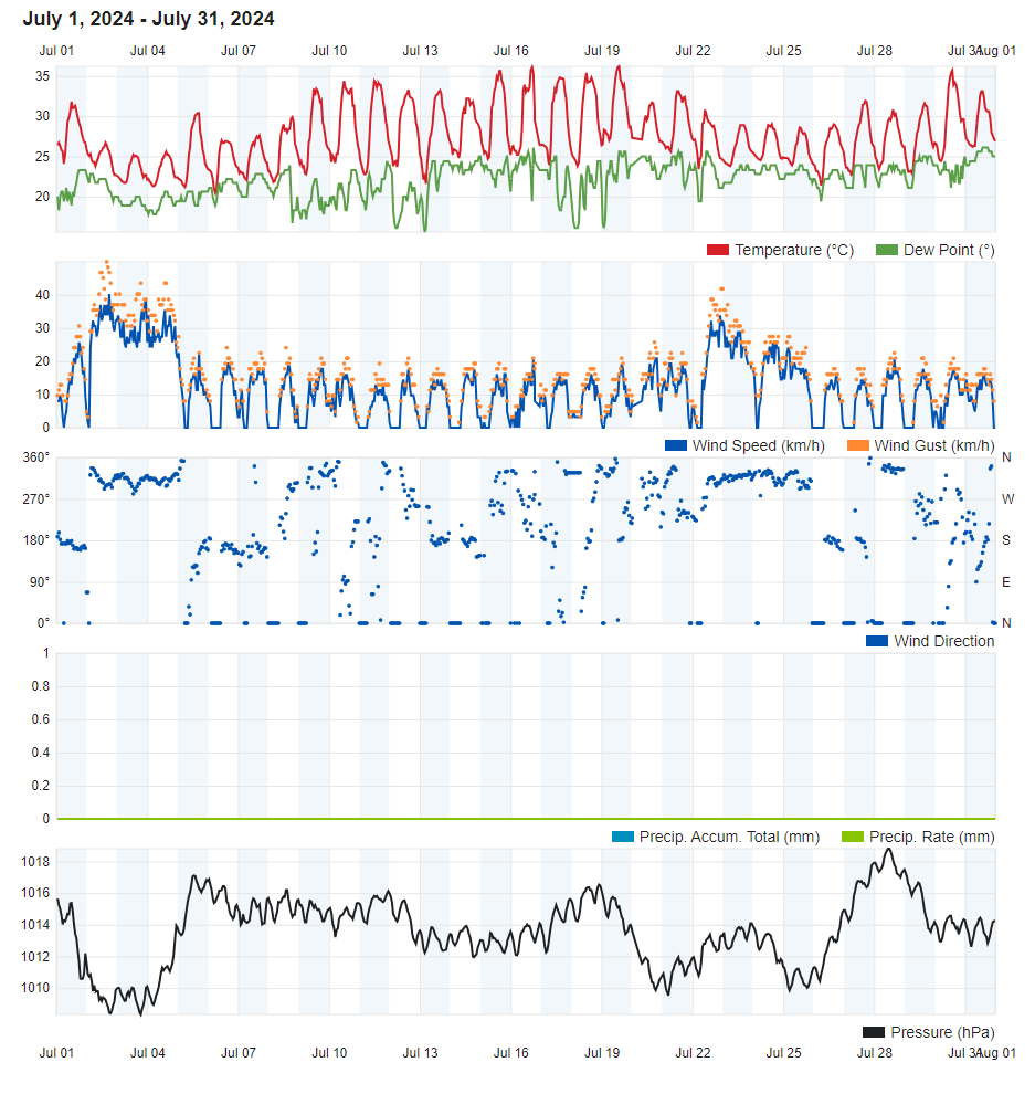
July 2024 – Warmer with Average Rainfall
August 2024 – Warmer and Drier
September 2024 – Warmer and Drier
October 2024 – Warmer and Drier
November 2024 – Warmer and Wetter
December 2024 – Warmer and Drier
2024: Dominated by Drier and Warmer than Average Weather
A staggering eleven months of twelve were marked by warmer than average temperature. A total of nine months recorded less precipitation than normal. Counting July, a typically bone dry month, raises the tally of dry months to ten months.
Overall, 2024 was 0.7˚C warmer than the norm. Both the mean maximum and mean minimum temperatures surpassed the average by 0.7˚C. A late start to summer allowed June to be the year’s only month with temperatures below the average.
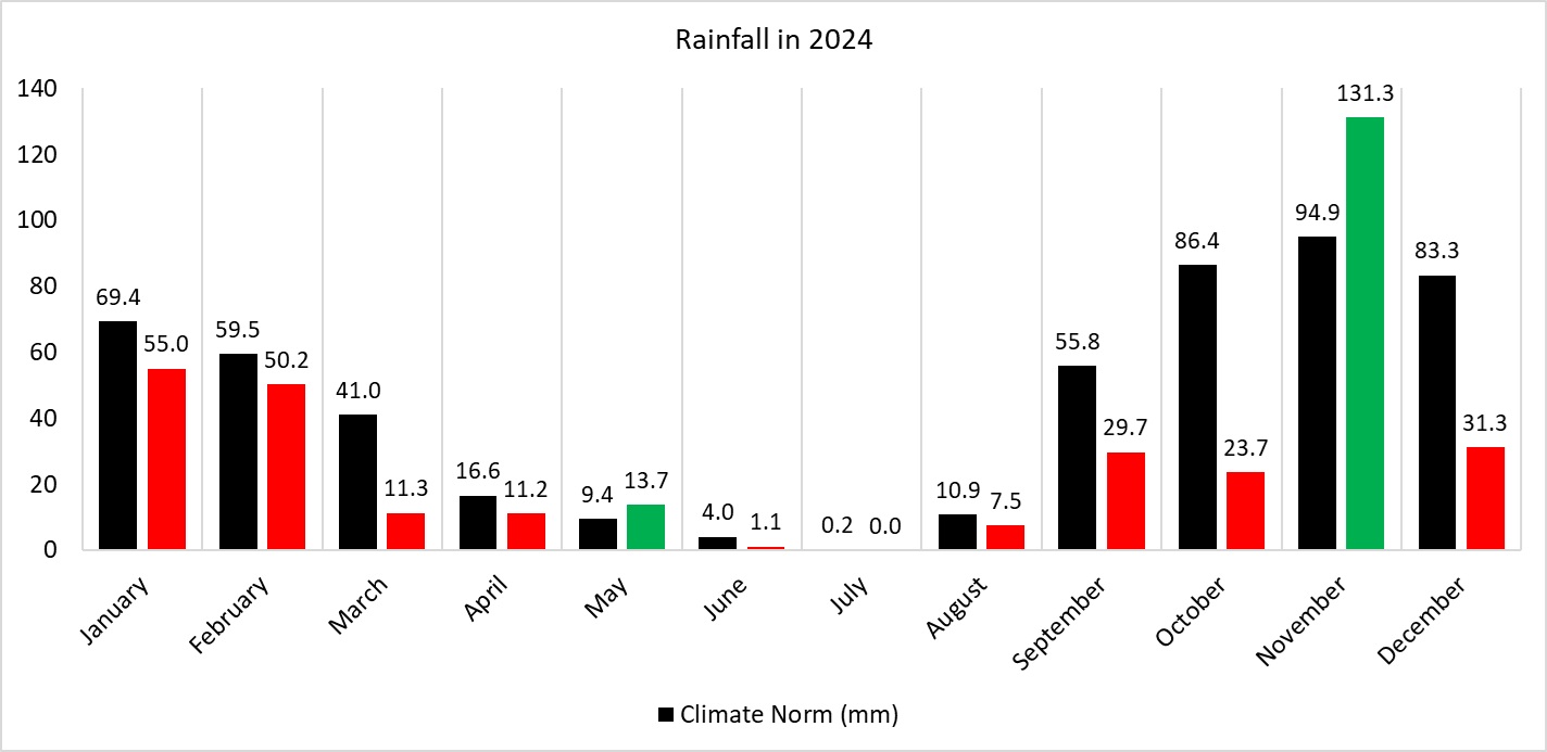
2024 was also the third consecutive year to register less rainfall than is expected. With a total of 366.5 mm, 2024 was also the driest year since 2016 and the second driest year since 2010. Total monthly rainfall exceeded the climate norm in two months; May and November. Being the third and final month of meteorological spring, May is typically dry and doesn’t take more than a single rainy day to meet the norm. November was the only month of the year to see the 100 mm mark being reached at our weather station. The highest 24-hour rainfall total was also very poor. An extremely inactive autumn meant that heavy rainfall events were very few and far between.
Numerous showers and a thunderstorm during the first half of January made for a wet start to 2024. The year may have started with a splash, but January’s total precipitation – which amounted to 55.0 mm – did not measure up to the climate norm. The national mean was at an even lower 44.2 mm. Apart from being drier than the climate norm, the month was also a full degree warmer than expected. Overall, February was a continuation of the long-standing warmer and drier than average trend set by all previous autumn and winter months. The third and final month of meteorological winter was marked by frequently changing meteorological conditions due to the passage of several areas of low pressure across our region. That month’s meteorological highlight, a hailstorm, struck central localities of Malta at around lunchtime on the 11th. This hailstorm coincided with the Sunday celebrations of Carnival. The hail was fairly large and abundant. The town of Mosta was particularly hard hit. March extended the trend of consecutive drier than average months to seven. The second half of the month was particularly warm, particularly due to a prevailing southerly wind. This blew desert sand from over the Sahara Desert towards our region. This sand led to widespread dense haze during Holy Week, from the 26th through to the 29th. April, the second month of meteorological spring, was characterized by changeable meteorological conditions. Temperatures fluctuated throughout the month. The opening day of the month, April Fool’s Day, was the month’s warmest day. The mercury soared to 28.3°C. Various localities across central Malta recorded values of around 30°C on that day. The month’s first few days led many to believe that an early summer was the cards for the Maltese Islands. This notion was short-lived. As a low-pressure system settled over the islands, the weather became increasingly windy and unstable. In fact, the second half of the month was largely dominated by instability; with mild temperatures, strong winds and also some showers being experienced. Warm temperatures in May were not complemented by bright sunshine and light winds. Airborne fine desert sand was present in the skies above the central Mediterranean on a total of 12 days. There were also 4 days with rain and 2 days with thunder. June 2024 was off to a rather bleak start. Light rain showers accompanied by loud thunder were observed on three days in the opening week. This was accompanied by temperatures well below the climate norm. Meteorological conditions took a more seasonal turn over the course of the second week, as summer slowly gained momentum. In fact, a very interesting feature in June was the persistence of airborne fine desert sand. A staggering 23 days were characterized by a thick blanket of haze from over north Africa. The fresher June temperatures continued into the first week of July. This came to an abrupt end around the 9th. A heat spell with sweltering temperatures lasted from the 9th through to the 22nd. This corresponded with a rapid rise in mean sea surface temperature. August 2024 lived up to the local saying “Awwissu x-xemx taħarqu u x-xita tmissu”. This is a local Maltese proverb describing August as being a very hot month, but also the month when we get the first rain. This was true, at least for some localities. The first two and a half weeks of the month lived up to their expectation of being the year’s hottest period. August 2024 was characterized by one main episode of instability and several localized showers. The day of the 28th saw isolated thunderstorms popping around the Maltese Islands. Referred to as “popcorn” or “pop-up” cells, these clouds formed spontaneously due to ground heating under an unstable atmosphere. This was followed by a more active thunderstorm in the evening. 3000 lightning strikes were registered across the central Mediterranean in two hours. The eighth month of the year, September, kicked off on a stifling note. Hot temperatures coupled with very high levels of humidity and a sticky southerly wind made conditions across the Maltese Islands very uncomfortable. This was brought to an end by outbreaks of instability which brought a series of showers, some of which included localized thunderstorms, to the central Mediterranean. Whilst most localities experienced moderate showers, a handful were affected by downpours. October brought generally dry warm weather to the Maltese Islands. This was the third consecutive year with a very dry October. It was also one of the driest on record. There was only one major rainfall event. After a day of near misses, an evening downpour on the 19th struck the northern half of Gozo with up to 70 mm in the villages of San Lawrenz and Għarb. Surrounding localities also received a decent share of rain. An extensive area of high pressure (anticyclone) prevailed over eastern Europe and the Mediterranean. Troughs of low pressure (storm systems) remained stuck over the western Mediterranean and northwestern Europe. This helped maintain a persistent easterly air flow across the central Mediterranean. Apart from making October the second consecutive month with the South Southeast as the predominant wind direction, it ensured that warm air was constantly advected from regions of the Sahara towards the central Mediterranean. November brought a long-standing pattern of drier than average months to an end. With a total of 131.3 mm of rainfall measured at our Gozo weather station, November 2024 was the first month since February 2023 to bring significant rainfall to our islands. This rain was spread over 10 days, with the vast majority of it falling in a cluster from the 8th till the 13th due to instability being locked over the central Mediterranean. Apart from a few days with light rain, the only other day with significant precipitation was the 30th. No extreme rainfall events were recorded, although some brief flooding was observed from a handful of downpours. December 2024 became the tenth consecutive drier-than-average December. Nationally, there were 18 days when at least one shower was measured in one part or another of the island. That is a staggering amount, when considering that rainfall totals were so poor. This is because rain came from isolated showers rather than extensive, widespread rain-bearing low pressure systems. Christmas Eve and Christmas Day shared the title for the lowest maximum temperature. At 13.2°C, it is also the lowest maximum temperature for the whole of 2024.

 Rainfall Totals around the Maltese Islands in August 2024 (and since last September 1st):