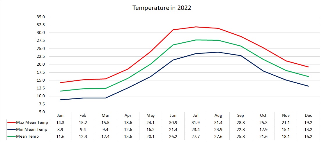
Air Temperature
| Highest Maximum | 38.3°C | 17th August 2022 |
| Lowest Maximum | 9.3°C | 25th January 2022 |
| Highest Minimum | 28.0°C | 18th August 2022 |
| Lowest Minimum | 2.9°C | 25th January 2022 |
| Mean Maximum | 23.0°C |
| Mean Minimum | 16.2°C |
| Mean | 19.6°C |
Relative Humidity
| Mean Relative Humidity | 75.8% |
Atmospheric Pressure
| Highest Atmospheric Pressure | 1035.0hPa | 15th March 2022 |
| Lowest Atmospheric Pressure | 996.1hPa | 21st April 2022 |
| Mean Atmospheric Pressure | 1017.6hPa |
Wind
| Highest Gust | 64.4 km/h (Force 8) | 28th November 2022 |
| Mean Wind Speed | 10.8 km/h |
| Most Frequent Wind Direction | Northwest |
Precipitation
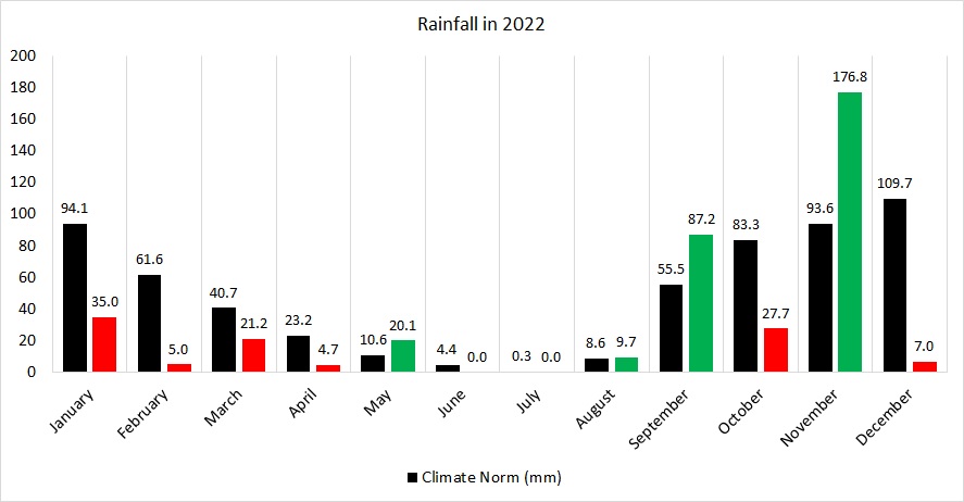
| Total Rainfall During 2022 | 394.5 mm |
| Highest 24 Hour Total | 40.9 mm | 22nd September 2022 |
| Rain Days | 57 days |
| Thunderstorm Days | 20 days |
| Hail Days | 11 days |
Rainfall Events
| 06/01/2022 | 1.3 mm | Light Rain |
| 09/01/2022 | 2.5 mm | Showers |
| 10/01/2022 | 6.6 mm | Showers |
| 12/01/2022 | 4.6 mm | Showers |
| 13/01/2022 | 18.1 mm | Rainy |
| 21/01/2022 | 0.5 mm | Light Rain |
| 24/01/2022 | 1.5 mm | Rain and Hail Shower; Thunder |
| 01/02/2022 | 3.3 mm | Rain and Hail Showers |
| 11/02/2022 | 0.3 mm | Dew |
| 13/02/2022 | 0.3 mm | Dew |
| 14/02/2022 | 0.3 mm | Light Rain |
| 16/02/2022 | 0.5 mm | Light Rain |
| 23/02/2022 | 0.3 mm | Light Rain |
| 01/03/2022 | 0.3 mm | Light Rain Shower. Hail and Thunder in Vicinity. |
| 05/03/2022 | 0.5 mm | Light Rain |
| 07/03/2022 | 0.8 mm | Light Rain |
| 12/03/2022 | 3.3 mm | P.M. Rain |
| 13/03/2022 | 13.7 mm | A.M. Rain. Thunder in Vicinity. |
| 19/03/2022 | 0.8 mm | Light Rain |
| 20/03/2022 | 0.5 mm | Light Rain |
| 21/03/2022 | 0.5 mm | Light Rain |
| 30/03/2022 | 0.5 mm | Light Rain |
| 31/03/2022 | 0.3 mm | Light Rain |
| 01/04/2022 | 0.5 mm | Light Rain |
| 07/04/2022 | 0.3 mm | Light Rain |
| 15/04/2022 | 0.8 mm | Light Rain |
| 16/04/2022 | 1.8 mm | Isolated Shower |
| 17/04/2022 | 0.8 mm | Isolated Shower |
| 18/04/2022 | 0.5 mm | Light Rain |
| 01/05/2022 | 0.8 mm | Light Rain |
| 02/05/2022 | 0.3 mm | Light Rain |
| 08/05/2022 | 6.1 mm | Rain Shower; Distant Thunder |
| 09/05/2022 | 0.3 mm | Light Rain |
| 29/05/2022 | 12.6 mm | Rain Shower; Distant Thunder and Hail |
| 10/08/2022 | 4.6 mm | Showers, Thunder in Vicinity |
| 11/08/2022 | 5.1 mm | Showers, Thunder in Vicinity, Waterspouts |
| 12/08/2022 | 0.0 mm | Thunder in Vicinity |
| 22/09/2022 | 40.9 mm | Steady Light Rain; P.M. Thunderstorm |
| 23/09/2022 | 39.2 mm | A.M. Thunderstorm |
| 25/09/2022 | 5.7 mm | A.M. Showers |
| 30/09/2022 | 1.4 mm | P.M. Shower; Distant Thunder |
| 10/10/2022 | 27.7 mm | Thunderstorm with Hail |
| 05/11/2022 | 21.2 mm | Isolated Showers; Thunderstorm with Hail |
| 12/11/2022 | 21.2 mm | Thunderstorm with Hail |
| 13/11/2022 | 2.4 mm | Isolated Shower |
| 14/11/2022 | 22.1 mm | Thunderstorm with Hail |
| 17/11/2022 | 9.3 mm | Shower; Distant Thunder |
| 20/11/2022 | 21.0 mm | Thunderstorm; Isolated Showers |
| 21/11/2022 | 10.4 mm | Showers |
| 22/11/2022 | 1.4 mm | Isolated Showers |
| 23/11/2022 | 1.8 mm | Isolated Showers |
| 24/11/2022 | 1.8 mm | Isolated Showers |
| 26/11/2022 | 15.9 mm | Thunderstorm; Severe Thunderstorm with Hail |
| 27/11/2022 | 11.7 mm | Showers |
| 29/11/2022 | 23.5 mm | Thunderstorms with Hail |
| 30/11/2022 | 13.1 mm | Thunderstorm with Hail |
| 02/12/2022 | 1.3 mm | Light Showers |
| 06/12/2022 | 0.2 mm | Mist/Fog and Dew |
| 07/12/2022 | 0.3 mm | Light Showers |
| 10/12/2022 | 2.5 mm | Showers; Distant Thunder |
| 11/12/2022 | 0.2 mm | Light Showers |
| 20/12/2022 | 0.5 mm | Mist/Fog and Dew |
| 26/12/2022 | 0.3 mm | Mist/Fog and Dew |
| 27/12/2022 | 0.5 mm | Mist/Fog and Dew |
| 28/12/2022 | 0.5 mm | Mist/Fog and Dew |
| 29/12/2022 | 0.2 mm | Mist/Fog and Dew |
| 30/12/2022 | 0.3 mm | Mist/Fog and Dew |
| 31/12/2022 | 0.2 mm | Mist/Fog and Dew |
2022 Compared to the Climate Means
| Climate Mean | 2022 | Anomaly | |
| Mean Maximum Temperature | 20.8°C | 23.0°C | +2.2°C |
| Mean Minimum Temperature | 15.6°C | 16.2°C | +0.6°C |
| Mean Temperature | 18.2°C | 19.6°C | +1.4°C |
| Mean Relative Humidity | 76% | 75.8% | -0.2% |
| Mean Atmospheric Pressure | 1016.5hPa | 1017.6hPa | +1.1hPa |
| Mean Wind Speed | 16.4 km/h | 10.8 km/h | -5.6 km/h |
| Most Frequent Wind Direction | West Northwest | Northwest | +22.5° |
| Total Rainfall | 585.6 mm | 394.5 mm | -191.1 mm |
| Total Rain Days | 84 days | 57 days | -27 days |
| Total Thunderstorm Days | 26 days | 20 days | -6 day |
| Total Hail Days | 8 days | 11 days | +3 days |
Month-by-Month Summary for 2022
January 2022 – Colder and Drier (REGISTERING ONE OF THE COLDEST JANUARY DAYS EVER)
February 2022 – Colder and Drier (AMONG THE DRIEST ON RECORD)
March 2022 – Colder and Drier (THE COLDEST IN DECADES)
April 2022 – Colder and Drier
May 2022 – Average Temperatures but Wetter
June 2022 – Warmer and Drier (HOTTEST ON RECORD)
July 2022 – Warmer with Average Rainfall
August 2022 – Warmer and Wetter
September 2022 – Warmer and Wetter
October 2022 – Warmer and Drier (NOTICEABLY CALM)
November 2022 – Warmer and Wetter
December 2022 – Warmer and Drier (WARMEST AND DRIEST ON RECORD)
2022: A Year that Shattered Records
2022 was a year that saw long-standing temperature and precipitation records fall. Numerous phenomena worth mentioning were observed.
2022 was significantly warmer than the climate norm. The mean temperature of 19.6˚C was 1.4 ˚C warmer that the norm. The greatest difference from the climate mean was registered in maximum temperatures. With a mean maximum temperature of 23.0˚C, days in 2022 were overall a staggering 2.2˚C warmer. The margin for mean minimum temperatures was of a far lower, but nonetheless significant, 0.6˚C. If we look at 2022 from a month-by-month point of view, however, we notice that it was indeed a year of two faces. The first four months (January to April) were colder than average. January’s mean minimum temperature was calculated at a chilly 8.9°C. January 25th accounted for 2022’s coldest night. The mercury that night dipped to a frosty 2.9°C. This was the coldest night in seven years. The day of January 25th also marked the first time in five years that the maximum temperature failed to reach the 10°C level. With a mean maximum temperature of 15.5°C and mean minimum temperature of 9.4°C, March 2022 was the coldest March in decades. The chilly 3.9°C recorded in the early hours of March 25th, made that night one of the coldest March nights on record. The synoptic situation for the first quarter of 2022 was marked by persistent high pressure across western Europe and successive zones of low pressure over the Balkans. This meteorological setting caused a series of cold snaps to traverse the central and eastern Mediterranean. This persistent cold also had implications on precipitation. The cold air masses that dominated our region prevented zones of low pressure from reaching our shores. Consequently, the first quarter of 2022 was drier than average by a wide margin. Rainfall was particularly scarce during February, causing it to be one of the driest on records.
The month of May was the only month with temperatures around norm. From then on, the atmosphere’s thermostat switched. The summer months were off to a sizzling start. With the mean temperature at an astounding 2.4°C warmer than the climatic mean, June 2022 broke the record for the hottest June on record. The rest of summer maintained the same warmer than average trend. Despite the intense heat, the summer months were lacking the persistent stability we are accustomed to. Cloud cover was greater than the norm throughout. The first rains came earlier too. The months of August 2022 and September 2022 both reported rainfall values higher than the climate norm. Towering cumulus clouds featured on the vast majority of days. The air closer to the surface was hot and humid. Simultaneously, cold air was present in the upper levels of the atmosphere. On numerous occasions, the hot and humid air was forced to rise. Upon reaching the colder air aloft, moisture within the air mass condensed to form dense clouds. These clouds typically start forming in the late morning and dissipate by the late afternoon, peaking in the mid-afternoon. They generated some intense downpours across parts of the Maltese Islands. Whilst temperatures remained very warm heading into autumn, October 2022 failed to deliver its promise of plentiful rainfall. November 2022, the third and final month of meteorological autumn was the wettest month of the year, registering more rain than double the amount of a typical November. Out of November’s 14 rainy days, the 26th was to produce last year’s most notable event. A severe thunderstorm produced very large hailstones of up to 2 centimetres diameter in Ħ’Attard. Damaging wind gusts were also recorded by weather stations in neighboring localities. The month of December 2022 rounded off a year of extremes by becoming the warmest and driest on record. The mean temperature of 16.2°C broke a decades-old record set in the 1960s by a fraction of a degree. Moreover, not a single day last month registered maximum temperatures at or below the climate norm of 17.1°C. December is statistically the wettest month of the year locally, but in 2022, even August would turn out to have produced more precipitation. December 2022 broke an almost century-old record set in the 1920s to become the driest December yet.
2022 will also be remembered for the unprecedented periods of calm it registered, especially in the later months. Wind in the Maltese Islands is very common because it is an island in the middle of the mid-latitude depressions’ path and in a band of pressure difference. On average, 92% of all days experience winds of at least Force 2. This means that only 25 days a year are windless. For a total of 15 consecutive days, in October, the wind speed averaged 1.7km/h (Force 1). No wind gusts were reported for days on end. A similar pattern was observed during Christmastime. The calm spell in late December was accompanied by incredibly high levels of humidity. The mean humidity in December was a damp 85.4%, with its levels failing to drop below the 80% mark on almost half of all days. Unsurprisingly, these humid conditions caused a lot of days with mist or fog patches and dewfall. Dewfall was heavy enough to measure on a staggering eight days.