Updates

For the latest updates related to the weather in the Maltese Islands. So keep yourself updated by visiting this page frequently or like our Facebook page.

Updates

This week: No rain and plenty of bright sunshine

An anticyclone expanding towards the western Mediterranean from Germany will expand further to also cover the central Mediterranean. This anticyclone, which is likely to be persistent, will be influencing our weather conditions throughout this coming week. In fact, all days this week will feature mainly sunny to partly cloudy skies, with long hours of uninterrupted bright sunshine. No rain is being anticipated for any day. As forecast, the first two days of the week will bring this winter’s coldest temperatures. The coldest, expected just before dawn on Monday 15/2, is likely to be in the region of 2°C to 3°C. These cold temperatures will feel colder due to the strong northerly wind. Temperatures will then climb gradually to reach 16°C / 17°C highs and 9°C / 10°C from Thursday 18/2 onward. As a result of stability brought about by anticyclonic conditions, the wind will die down by midweek, with mainly light and variable winds being anticipated from there on.

Updates

STRONG WIND WARNING / TWISSIJA TA’ RIĦ QAWWI

ENGLISH/INGLIŻ

An intense low pressure system over central Italy will migrate towards the eastern Mediterranean. Meanwhile, an anticyclone over Germany will expand south towards the wester Mediterranean. The contrast between the two will generate a strong Northwest to Northeast wind. This strong wind warning is valid from 18:00 on Saturday 13/2 till 09:00 on Sunday 14/2.


Saturday 13/2 

18:00 to 21:00 – West Northwest Force 6

21:00 to 00:00 – West Northwest Force 6 to 7 (with gusts of up to Force 8)

Sunday 14/2

00:00 to 03:00 – West Northwest to North Northwest Force 7 (with gusts of up to Force 8)

03:00 to 06:00 – North Northwest to Northeast Force 7 to 6 (with gusts of up to Force 8)

06:00 to 09:00 – Northeast Force 6


The peak gusts will blow across the Maltese Islands just after midnight on Sunday 14/2, when they will reach Force 8 across exposed areas of the Maltese Islands. The sea will be rough to very rough at times with a significant wave height of 4.5 meters from the Northwest in peak gusts. The swell will be a low Northwest during the strong wind, but will become a moderate Northeast during the day. The map below indicates the stretch of coastline most exposed to the rough sea generated by this strong wind and the moderate swell that will follow.

The Northeast wind will continue being strong at times throughout the first half of next week.


MALTI / MALTESE

Sistema ta’ pressjoni baxxa intensa fuq iċ-ċentru ta’ l-Italja se tersaq lejn il-lvant tal-Mediterran. Fl-istess waqt, antiċiklun fuq il-Ġermanja se jespandi lejn in-nofsinhar u jgħatti l-punent tal-Mediterran. Dan il-kuntrast se jwassal għal riħ qawwi mill-Majjistral għal Grigal. Din it-twissija ta’ riħ qawwi se tkun fis-seħħ minn 18:00 tas-Sibt 13/2 sa 09:00 tal-Ħadd 14/2.


Is-Sibt 13/2 

18:00 sa 21:00 – Punent Majjistru Forza 6

21:00 sa 00:00 – Punent Majjistru Forza 6 għal 7 (b’buffuri ta’ Forza 8)

Il-Ħadd 14/2

00:00 sa 03:00 – Punent Majjistru għal Majjistral it-Tramuntana Forza 7 (b’buffuri ta’ Forza 8)

03:00 sa 06:00 – Majjistral it-Tramuntana għal Grigal Forza 7 għal 6 (b’buffuri ta’ Forza 8)

06:00 sa 09:00 – Grigal Forza 6


Il-buffuri l-aktar qawwija se jaħkmu l-Gżejjer Maltin eżatt wara nofsillejl tal-Ħadd 14/2, meta dawn se jilħqu Forza 8 fl-inħawi l-aktar esposti. Il-baħar se jkun qawwi għal qawwi ħafna kultant b’mewġ għoli 4.5 metri mill-Majjistral fl-aktar buffuri intensi. L-imbatt se jkun baxx Majjistral fir-riħ qawwi, imbagħad isir moderat Grigal matul il-jum. Il-mappa ta’ hawn taħt tindika l-inħawi tal-kosta l-aktar esposti għal mewġ għoli ġġenerat minn dan ir-riħ qawwi u l-imbatt moderat li se jsegwih.

Ir-riħ mill-Grigal se jibqa jkun qawwi kultant sa minn ta’ l-anqas l-ewwel nofs tal-ġimgħa li ġejja.

Updates

Three frigid days / Tlett ijiem ta’ kesħa ġelida

ENGLISH/INGLIŻ

The combination of an intense low pressure system over the eastern Mediterranean and an anticyclone over the western Mediterranean will be drawing in frigid air from Russia’s Siberia. This outbreak of cold air will impact eastern and southern Europe. The Maltese Islands will be just within reach of this cold air. The air temperature will be significantly colder than average on three days: Sunday 14/2, Monday 15/2 and Tuesday 16/2. Monday 15/2, the coldest of the three days, will see the temperature remaining below 10°C at all times. The daytime high will struggle to reach 12°C on the other two days. Nighttime lows may dip to as low as 3°C on all three days. The frigid northerly wind will mean realfeels of below 10°C by day and below 0°C at times by night. Sunday 14/2 will be the only wet day of the three. This is because the cold air will clash with the warm air locally on arrival, sparking a rainy episode. Hail is likely to accompany the rain at times. Although less likely, thunder is also possible. Total rainfall accumulations may exceed 10 mm in areas. Temperatures will settle at around average (highs of 14°C / 15°C and lows of 8°C / 9°C) from Wednesday 17/2 onward.

Before any cold snap, we’re often asked if the Maltese Islands could get any snow. The answer to this question is a convincing “No”. This is because of two reasons: the air temperature will not be cold enough and the sea’s moderating affect doesn’t permit snow to reach the ground across the Maltese Islands. We may still experience an interesting phenomenon, however. It is the occurrence of graupel (also referred to as soft hail). This is a form of precipitation which resembles crumbled polystyrene (jablo) that forms when supercooled droplets of water are collected and freeze on a falling snowflake, forming a 2-5 mm ball of rime. They fall gently like snow, so it’s easy to tell hail and graupel apart.

Anyone wishing to glimpse a sight of Sicily (and probably also the snow-covered Mount Etna) on the horizon will certainly be able to do so on these days.


MALTI / MALTESE

Il-kumbinazzjoni ta’ sistema ta’ pressjoni baxxa intensa fuq il-lvant tal-Mediterran u antiċiklun fuq il-punent tal-Mediterran se tiġġenera kurrenti kesħin ħafna minn fuq is-Siberja tar-Russja. Din l-arja ġelida se taffetwa l-lvant u n-nofsinhar ta’ l-Ewropa. Il-Gżejjer Maltin se jkun fil-mira ta’ din il-kesħa wkoll. It-temperaturi se jkunu ħafna anqas mill-medja għal tlett ijiem: il-Ħadd 14/2, it-Tnejn 15/2 u t-Tlieta 16/2. Matul nhar it-Tnejn 15/2, l-aktar jum kiesaħ minnhom, it-temperatura għandha tibqa taħt l-10°C il-ħin kollu. L-ogħla temperatura se tbati biex tilħaq it-12°C fil-jumejn l-oħra. It-temperatura matul it-tlett iljieli li huma taf tinżel sa 3°C. Ir-riħ kiesaħ mit-Tramuntana se jfisser li t-temperaturi matul il-jum jinħassu daqs li kieku taħt l-10°C, waqt li dawk ta’ billejl xi kultant jinħassu daqs li kieku taħt ż-0°C. Il-Ħadd 14/2 se jkun l-uniku jum bix-xita. Mal-wasla tagħha, l-arja kiesħa tiltaqa ma’ l-arja sħuna u umda madwarna u toħloq episodju ta’ xita. Dan għandu jkun akkumpanjat minn silġ. Għalkemm mhux daqstant possibli, jaf ikollna xi ragħad ukoll. It-total ta’ xita kapaċi jaqbeż l-10 mm f’xi nħawi. It-temperaturi se jirritornaw għal medja klimatika (l-ogħla ta’ 14°C / 15°C u l-anqas ta’ 8°C / 9°C ) minn nhar il-Erbgħa 17/2 ‘il quddiem.

Qabel kull episodju ta’ kesħa, ħafna jistaqsuna jekk hux possibbli li f’Malta tagħmel il-borra. It-tweġiba għal din il-mistoqsija hija “Le”. Dan għal żewġ raġunijiet: il-fatt li t-temperatura ta’ l-arja mhux se tkun kiesħa biżejjed u l-effett li l-baħar ikollu fuq l-arja ma jħallix borra tasal sa l-art fil-Gżejjer Maltin. Minkejja dan, xorta waħda jeżisti ċ-ċans li nesperjenzaw fenomenu xi ftit interessanti. Dan huwa silġ irqiq (graupel). Dan huwa forma ta’ preċipitazzjoni li fl-għamla tiegħu jixbah it-tajjar jew ġablo li jifforma meta ilma kiesaħ f’forma likwida jitħallat mal-borra waqt l-inżul mis-sħab u jifforma frak bid-daqs ta’ 2-5 mm. Dawn jinżlu bilmod bħal borra, u għalhekk wieħed faċilment jiddistingwi dan is-silġ irqiq minn silġ normali.

Kull min jixtieq jilmaħ lil Sqallija (u probabilment anke l-vulkan Etna) se jkun jista jagħmel dan matul dawn il-jiem ta’ kesħa.

Updates

3 Hourly Forecast for the Feast of St.Paul’s Shipwreck (10/02/2021)

00:00 to 03:00 – mainly clear; 13°C / 14°C; South Force 3
03:00 to 06:00 – mainly clear; 13°C / 14°C; South Force 3
06:00 to 09:00 – mainly clear; 14°C to 16°C; South to South Southwest Force 3 to 4
09:00 to 12:00 – mainly clear; 16°C to 20°C; South Southwest to Southwest Force 4 to 5
12:00 to 15:00 – partly cloudy; 19°C / 20°C; Southwest Force 5 to 6
15:00 to 18:00 – variably cloudy; 19°C to 16°C; Southwest Force 6 to 5
18:00 to 21:00 – variably cloudy; 16°C to 14°C; Southwest Force 5
21:00 to 00:00 – variably cloudy; 13°C / 14°C; Southwest Force 5

Christianity has been the Maltese Islands for almost 2000 years. It was brought to the islands by the Apostle Paul in around 60 A.D. Paul was on his way to Rome to be tried, but the ship carrying him was caught in a violent storm and ended up being shipwrecked in Malta. All aboard swam safely to land. The site of the wreck is traditionally known as St.Paul’s Island. 10th February is a public holiday in Malta. The feast is celebrated in Valletta.

Updates

This week: Mainly dry, but rather breezy

The central Mediterranean will find itself sandwiched in between zones of low pressure over the Gulf of Genoa and a persistent ridge of high pressure over Libya for much of this week. The ridge of high pressure to our south will maintain mainly sunny to partly cloudy skies over the Maltese Islands on most days this week. The zones of low pressure over the Gulf of Genoa will be strong enough to direct successive bouts of strong winds across the central Mediterranean, however. The wind, which will alternate from the West Southwest to West Northwest, will be strong at some point on all days this week (up to Force 6 or 7). The southerly expansion of low pressure in the coming weekend may bring cloudier skies and possibly a little rain to the central Mediterranean. Although marginally cooler than of late, temperatures will still be warmer than  average throughout this week. Maximum temperatures will be average at 17°C with minimum temperatures very likely to be in the region of 12°C on most nights. Sunday 14/2 looks set to be the coolest day this week, as a result of a potential incursion of colder air from the north.

Updates

Warmer and brighter weather on the way / Ġej temp aktar xemxi u sħun

ENGLISH/INGLIŻ

A ridge of high pressure will establish itself over the central Mediterranean on Wednesday 3/2. It will prevail across our region till at least Sunday 7/2, but may extend for longer. The high pressure will mean brighter weather, as variably to mostly cloudy skies give way to mainly sunny or partly cloudy skies. The cool and dry northwesterly wind will make way for a warm and humid southerly wind. The advection of warm air from the Sahara Desert towards the central Mediterranean will cause temperatures to rise to daytime highs of 19°C to 21°C. Nighttime lows will be maintained at above 14°C. Given the southerly winds, which may be fairly strong at times, there may be episodes of airborne fine desert sand. This would cause the air to be hazy at times.


MALTI / MALTESE

Firxa ta’ pressjoni għolja se tistabilixxi ruħha fuq iċ-ċentru tal-Mediterran nhar il-Erbgħa 3/2. Din se tippersisti madwar ir-reġjun tagħna sa minn ta’ l-anqas il-Ħadd 7/2, imma taf testendi għal aktar. Pressjoni għolja tfisser temp aktar ċar, b’sema il-biċċa l-kbira xemxi jew ftit imsaħħab. Ir-riħ frisk u niexef mill-majjistral se jċedi għal riħ sħun u umdu minn nofsinhar. L-arja sħuna li se testendi għal fuqna minn fuq id-deżert tas-Saħara se twassal biex it-temperaturi jiżdied għal massimu ta’ 19°C sa 21°C matul il-jum. L-anqas billejl se żżomm fuq l-14°C. Minħabba riħ minn nofsinhar, le jaf ikun xi ftit qawwi kultant, jista jkollna xi trab fin fl-arja minn ħin għal ieħor. Dan iwassal biex l-arja tkun imdaħħna kultant.

Updates

This week: Becoming warmer and brighter

A zone of instability spanning the central Mediterranean will linger till midweek. The opening days of this week will feature variably to mostly cloudy skies and the likelihood of isolated showers. The wind, from the West to Northwest, will maintain its Force 5 to 6 strength. Halfway through the week, a ridge of high pressure will extend to cover the central Mediterranean, bringing finer weather from Wednesday 3/2 onward. We’re expecting the second half of this week to bring plentiful bright sunshine. The cool and dry westerly wind will give way to warm and humid southerly air currents by midweek. These will be mainly light to moderate in strength. The only exception could be Sunday 7/2, when the wind could be strong at times brasil-libido.com. Temperatures will be significantly warmer than average throughout. With an average maximum temperature of 18°C and an average minimum temperature of 13°C, temperatures will be a staggering 2°C to 3°C warmer than what we are accustomed to at this stage of winter. Daytime highs will range from 16°C to 20°C, while nighttime highs will vary from 11°C to 15°C.

Updates

GALE-FORCE WIND WARNING / TWISSIJA TA’ RIEFNU

ENGLISH/INGLIŻ

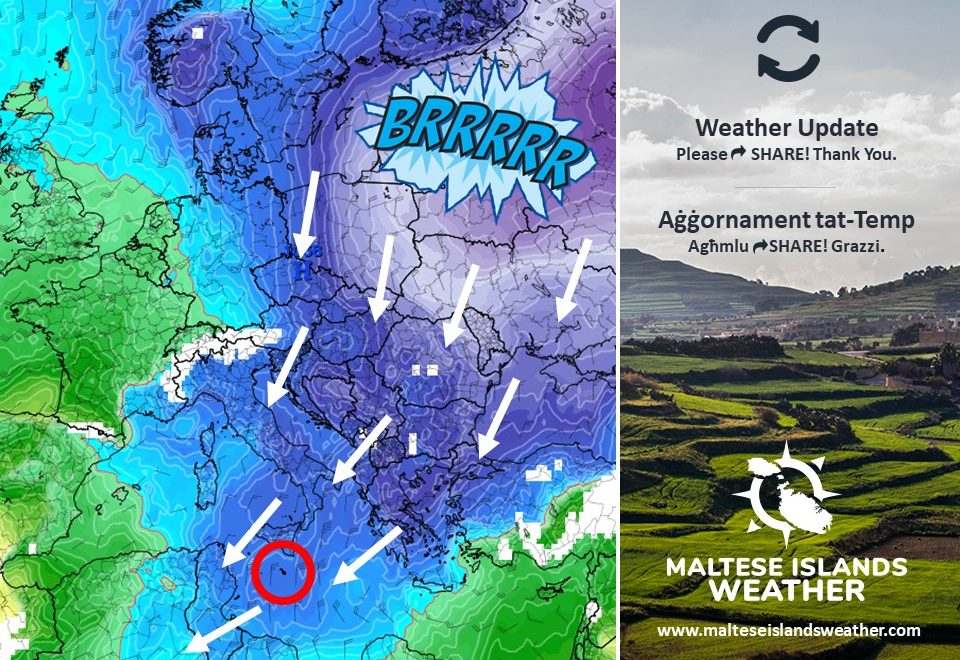
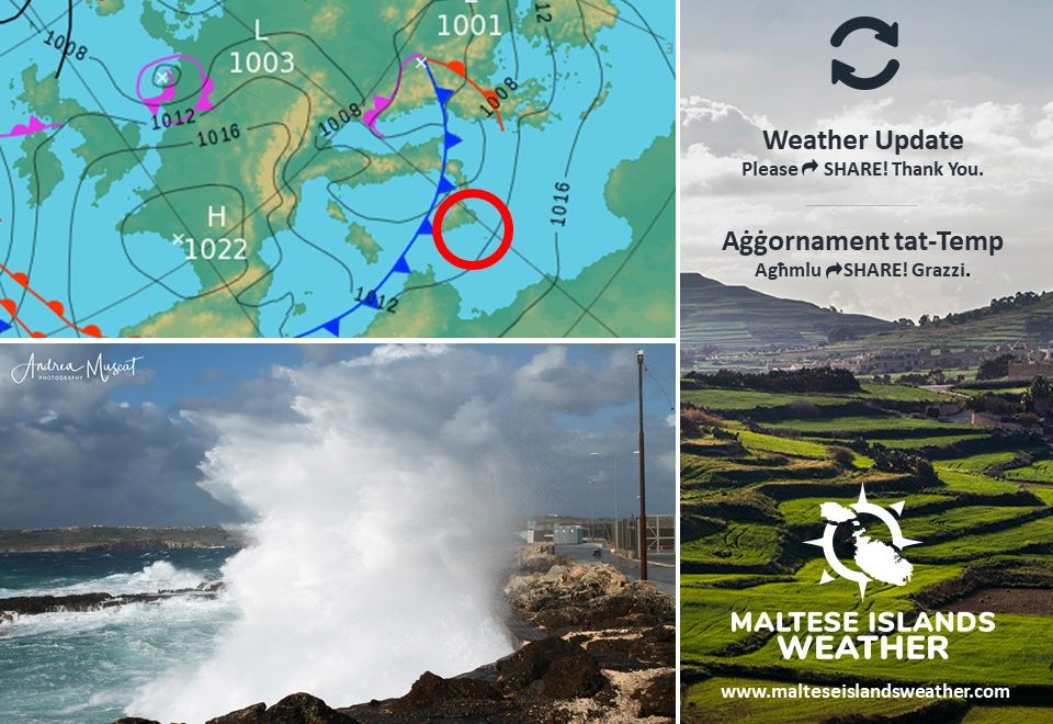
A cold front associated with an intense low pressure system over northern Italy will traverse the central Mediterranean in the morning of Tuesday 26th January. This will generate a brief gale from the Northwest across the central Mediterranean. This warning is valid from 09:00 till 23:59 on Tuesday 26th January. The warning will be updated when and if necessary. The information below describe how the situation will develop over this time period.


Tuesday 26th January

09:00 to 12:00 – Southwest Force 3 to 4, increasing rapidly to Northwest Force 7 (with gusts of up to Force 8)

12:00 to 15:00 – Northwest Force 7 (with gusts of up to Force 8)

15:00 to 18:00 – Northwest Force 7 (with gusts of up to Force 8)

18:00 to 21:00 – Northwest Force 6 to 7

21:00 to 00:00 – Northwest Force 5 to 6


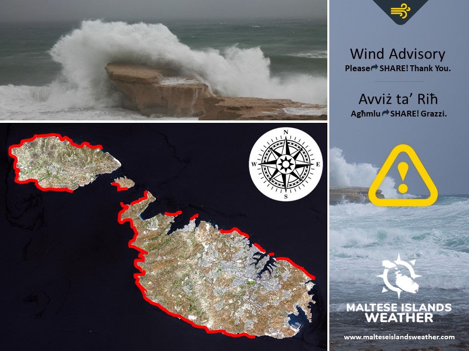
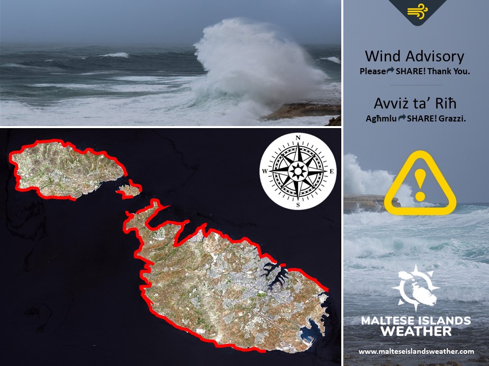
The peak gusts will blow across the Maltese Islands in the early afternoon, when they could reach Force 8 (possibly Force 9) at times across exposed areas of the Maltese Islands. The sea will be very rough, with wave heights of up to 4.5 metres in peak gusts. The swell will be a low Northwest during the day on Tuesday 26th January. The map shows the coast most exposed to this strong wind and rough sea. A brief but heavy rain showers, possibly with hail, will accompany the rapid strengthening of the wind.

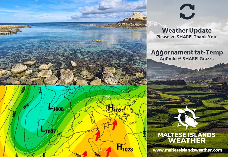
The Northwest wind will decline gradually to become mainly light (Force 3 to 4) by morning on Wednesday 27th January.


MALTI / MALTESE

Front kiesaħ abbinat ma’ sistema intensa ta’ pressjoni baxxa lejn in-naħa ta’ fuq ta’ l-Italja se jgħaddi minn fuq iċ-ċentru tal-Mediterran matul matul filgħodu tat-Tlieta 26 ta’ Jannar. Dan se jkun qed joħloq riefnu mill-Majjistral madwar iċ-ċentru tal-Mediterran. Dan se jdum biss ftit siegħat. Din it-twissija se tkun fis-seħħ minn 09:00 sa 23:59 tat-Tlieta 26 ta’ Jannar. Din it-twissija tkun aġġornata x’ħin u jekk ikun hemm bżonn. Id-dettalji ta’ hawn taħt jindikaw kif se tkun qed tiżviluppa din is-sitwazzjoni matul il-ħin imsemmi:


It-Tlieta 26 ta’ Jannar

09:00 sa 12:00 – Lbiċ Forza 3 għal 4, li jissaħħaħ f’daqqa għal Majjistral Forza 7 (b’buffuri sa Forza 8)

12:00 sa 15:00 – Majjistral Forza 7 (b’buffuri sa Forza 8)

15:00 sa 18:00 – Majjistral Forza 7 (buffuri sa Forza 8)

18:00 sa 21:00 – Majjistral Forza 6 għal 7

21:00 sa 00:00 – Majjistral Forza 5 għal 6


Il-buffuri l-aktar qawwija se jolqtu lill-Gżejjer Maltin kmieni wara nofsinhar, u jafu jilħqu sa Forza 8 (possibilment Forza 9) kultant fl-inħawi l-aktar esposti tal-Gżejjer Maltin. Il-baħar se jkun imqalleb ħafna, b’mewġ għoli 4.5 metri fil-buffuri l-aktar qawwija. L-imbatt se jkun baxx mill-Majjistral matul il-jum tat-Tlieta 26 ta’ Jannar. Il-mappa ta’ hawn taħt turi l-kosta l-aktar esposta għal dan ir-riħ qawwi u baħar imqalleb. Ħalba xita qasira imma qawwija, possibilment bis-silġ, se takkumpanja l-bidu ta’ dan ir-riħ qawwi.

Ir-riħ mill-Majjistral jonqos gradwalment biex isir il-biċċa l-kbira ħafif (Forza 3 għal 4) minn filgħodu ta’ l-Erbgħa 27 ta’ Jannar.

Updates

Cold front ahead / Ġej front kiesaħ

ENGLISH/INGLIŻ

A cold front associated with a low pressure system over northern Italy will traverse the central Mediterranean in the morning of Tuesday 26th January, and will affect the Maltese Islands in three ways.

  1. Temperature: The temperature will fall gradually over the course of the day, starting off at 15°C and dipping to 8°C by its end. The colder temperatures will linger on till the evening on Thursday 28th January, when temperatures should rise again.


  1. Wind: The wind will be mainly light (Force 3 to 4) from the Southwest till the arrival of the cold front, at around mid-morning. Its arrival will be marked by a sudden shift of the wind to the Northwest and a rapid strengthening to Force 7 (with Force 8 gusts). The wind will decline gradually from the evening to become mainly light (Force 3 to 4) by morning on Wednesday 27th


  1. Rainfall: The arrival of the cold front should also bring a brief, but heavy, rain shower. Small hail may also accompany this shower. Lighter rain is possible ahead of or after this shower. This rain shower will coincide with the strengthening of the wind. Rainfall accumulations will not be particularly high.


More stable weather will return on Wednesday 27th January.


MALTI / MALTESE

Front kiesaħ abbinat ma’ sistema ta’ pressjoni baxxa lejn in-naħa ta’ fuq ta’ l-Italja se jaqsam minn fuq iċ-ċentru tal-Mediterran matul filgħodu tat-Tlieta 26 ta’ Jannar, u għandu jaffetwa il-Gżejjer Maltin fi tliet modi.

  1. Temperatura: It-temperatura se tonqos gradwalment matul il-jum, minn livell ta’ 15°C għal-ewwel sa 8°C lejn tmiem il-jum. It-temperaturi kesħin se jippersistu sa filgħaxija tal-Ħamis 28 ta’ Jannar, meta t-temperatura jerġgħu jisħnu mill-ġdid.


  1. Riħ: Ir-riħ se jkun fil-maġġoranza tiegħu ħafif (Forza 3 għal 4) mill-Lbiċ sa ma jasal dan il-front kiesaħ. Mal-wasla tiegħu, lejn nofs filgħodu, ir-riħ jaqleb Majjistral u jissaħħaħ f’daqqa għal Forza 7 (b’buffuri ta’ Forza 8). Ir-riħ jonqos gradwalment minn filgħaxija biex isir il-biċċa l-kbira ħafif (Forza 3 għal 4) minn filgħodu ta’ l-Erbgħa 27 ta’ Jannar.


  1. Xita: Il-wasla ta’ dan il-front kiesaħ se tkun immarkata wkoll b’ħalba xita qasira imma qawwija. Silġ żgħir jista jakkumpanja din il-ħalba xita wkoll. Xita aktar ħafifa taf tmissna wkoll qabel u wara din il-ħalba xita. Din ix-xita għandha tasal fl-istess waqt li jitqawwa r-riħ. It-total ta’ xita mhux se jkun partikularment għoli.


Temp aktar stabbli jirritorna minn l-Erbgħa 27 ta’ Jannar.

Updates

This week: Characterized by frequent strong winds

Most days this week will feature variably cloudy skies. The only rain this week appears to be coming in the form of a few isolated showers on Tuesday 26/1 and/or Wednesday 27/1. The weekend promises to bring plenty of bright sunshine for a change. With daytime highs hovering at around 15°C and nighttime lows dipping to around 10°C, weekdays should be characterized by seasonal temperatures. The coldest day this week is likely to be Wednesday 27/1, when the minimum at night could drop to below 10°C. Temperature values should rise substantially by the weekend, with maximum temperatures likely to be at 18°C / 19°C and minimum temperatures possibly staying as warm as 13°C / 14°C. A trend that will probably be maintained throughout this week is that of rather strong winds. Winds should reach at least Force 6 on some four or five days. The predominant wind direction will be the westerly. It will tend to be from the West Northwest on weekdays, but is likely to shift to the West Southwest at the weekend.