Updates

For the latest updates related to the weather in the Maltese Islands. So keep yourself updated by visiting this page frequently or like our Facebook page.

Updates

A cold and calm night ahead / Ġej lejl ta’ kesħa u kalma

ENGLISH/INGLIŻ

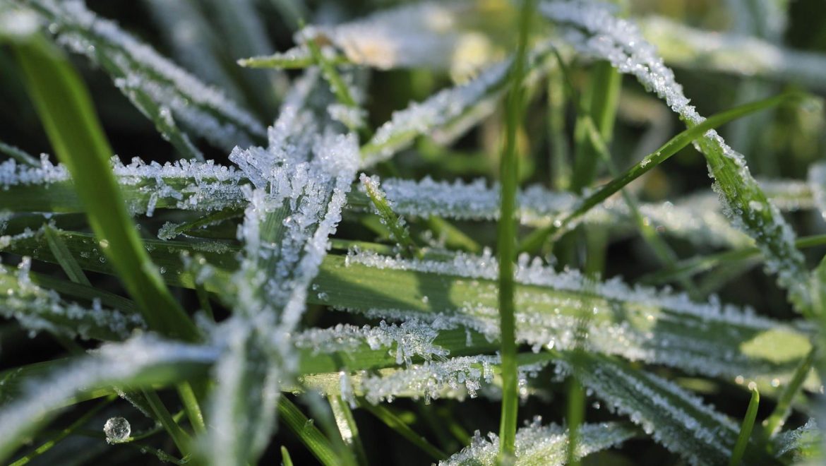
A cold night lies ahead for the Maltese Islands. This is due to a clear sky and calm wind under anticyclonic conditions. In the cooler months, calm and clear conditions allow heat to be lost from the surface of the Earth to space by radiation. This temperatures to fall steadily. As the stable air near to the ground cools, it can become saturated. Saturation leads to the formation of mist, fog and dew. In fact, dense fog patches may develop across plains and in valleys. For this reason, we urge you to express caution on the road. We’re expecting the air temperature to dip to 5°C / 6°C tonight. Temperatures typically reach the minimum just before dawn, after a night of cooling. Since cold air sinks, and due to the moderating effect of the sea, the coldest spots will be inland low-lying plains and valleys. On a sunny day, soil temperatures are often much warmer than the air temperature, but on clear nights, soil temperatures are normally a few degrees cooler than air temperatures. In fact, the soil temperature tonight may be as low as 1°C to 4°C. The Maltese Islands normally see one or two occasions of ground frost a year in the months of January or February. Tonight could be one of those rare occasions. Ground frost occurs when dew freezes as a result of a low soil temperature. Although not as evident as the frost abroad, even the slightest of frost poses a big headache to farmers, as crops tend to experience burns.


MALTI / MALTESE

Jidher li l-Gżejjer Maltin se jesperjenzaw lejl ta’ kesħa fina. Dan minħabba sema ċar u assenza totali ta’ riħ taħt kundizzjonijiet antiċikloniċi. Fix-xhur kesħin, temp ċar u kalm ifisser li l-arja tiksaħ sew. Dan minħabba li l-arja titlef s-sħana lejn l-ispazju bla tfixkil. Hekk kif l-arja tiksaħ, din ma tibqax tiflaħ iżżomm ħafna fwar u l-umdita toqrob l-100%. Umdita għola tinkoraġixxi l-iżvilupp ta’ ċpar u nida. Filfatt, jaf ikollna rqajja ta’ ċpar dens f’inħawi bi pjanuri u fil-widien. Għal din ir-raġuni nitolbukom iżjed kawtela fis-sewqan. Qed nistennew li t-temperatura ta’ l-arja tinżel sa 5°C / 6°C billejl. It-temperatura normalment tilħaq il-minimu tagħha ftit qabel sbieħ il-jum, wara li l-arja tkun ilha lejl titlef is-sħana. Minħabba li l-arja kiesħa żżomm fil-baxx, u l-effett ta’ moderazzjoni li l-baħar għandu fuq l-arja, l-inħawi l-aktar kesħin ikunu dawk fuq pjanuri jew f’widien baxxi lejn iċ-ċentru tal-gżejjer. Matul jum xemxi, it-temperatura tal-ħamrija tkun ferm ogħla minn dik ta’ l-arja. Bil-kontra, matul lejl ċar, it-temperatura tal-ħamrija ssoltu tkun ftit gradi aktar kiesħa minn dik ta’ l-arja. Filfatt, it-temperatura tal-ħamrija llejla taf tinżel bejn 1°C u 4°C. F’okkażjonijiet rari, ta’ xi darba jew tnejn fis-sena matul ix-xahrejn ta’ Jannar u Frar, il-Gżejjer Maltin jesperjenzaw dik li nsejjħulha ġlata. Il-lejl li ġej jaf ikun wieħed minn dawn. Il-ġlata tifforma meta n-nida ta’ mal-weraq tiffriża minħabba temperatura tal-ħamrija kiesħa. Għalkemm mhux evidenti daqs il-ġlata ta’ barra, anke ftit biss hija ta’ wġigħ ta’ ras kbira għal-bdiewa, minħabba l-fatt li l-prodott agrikolu jista jinħaraq u jinxef.


Updates

This week: Becoming milder after midweek

The seasonal cold temperatures that have characterized our weather in recent days will be maintained till midweek. The 13°C / 14°C highs and 7°C / 8°C lows will give way to milder 16°C to 18°C highs and 12°C to 14°C lows by midweek, as the weather appears to be taking a milder turn. To confirm a mild outlook, the latest maps indicate that we shouldn’t expect much in the way of rain this week. The only rain this week appears to be coming in the form of isolated showers. These are likely before dawn on Monday 18/1 and over the coming weekend. Most days will feature partly to variably cloudy skies with some dappled sunshine. A very strong Northwest wind will die down completely by the evening on Monday 18/1. A general calm is likely to prevail on Tuesday 19/1. The wind will then turn Southwest to West from Wednesday 20/1 onward, and once again increasing to Force 5+ https://southafrica-ed.com/kamagra-in-south-africa/.

Updates

GALE-FORCE WIND WARNING / TWISSIJA TA’ RIEFNU

ENGLISH/INGLIŻ

A cold front associated with an intense low pressure system over the Tyrrhenian Sea will traverse the central Mediterranean on the evening of Sunday 17/1. A ridge of high pressure will develop over France. This contrast will generate a brief gale from the West Northwest across the central Mediterranean. This warning is valid from 15:00 on Sunday 17/1 till 09:00 on Monday 18/1. The warning will be updated when and if necessary. The details below describe how the situation will develop over this time period:


Sunday 17/1 

15:00 to 18:00 – West Force 5 to 6

18:00 to 21:00 – West Force 6 to 7 (with gusts of up to Force 8)

21:00 to 00:00 – West Force 7 (with gusts of up to Force 8)

Monday 18/1

00:00 to 03:00 – West to West Northwest Force 7 (with gusts of up to Force 8)

03:00 to 06:00 – West Northwest Force 6 to 7 (with gusts of up to Force 8)

06:00 to 09:00 – West Northwest Force 5 to 6


The peak gusts will blow across the Maltese Islands around midnight, when they could reach Force 8 (possibly Force 9) at times across exposed areas of the Maltese Islands. The sea will be very rough, with wave heights of up to 5.5 metres in peak gusts. The swell will be a moderate to low Northwest during the day on Monday 18/1. The map shows the coast most exposed to this strong wind and rough sea. Isolated showers will accompany the strong winds.

The West Northwest wind will decline to Force 5 in the morning on Monday 18/1, before veering Northeast and decreasing further to become Calm by evening on Monday 18/1.


MALTI / MALTESE

Front kiesaħ abbinat ma’ sistema intensa ta’ pressjoni baxxa fuq il-Baħar Tirren se tgħaddi minn fuq iċ-ċentru tal-Mediterran matul filgħaxija tal-Ħadd 17/1. Firxa ta’ pressjoni għolja se tiżviluppa fuq Franza. Dan il-kuntrast se joħloq riefnu mill-Punent Majjistru, madwar iċ-ċentru tal-Mediterran, li se jdum biss ftit siegħat. Din it-twissija se tkun fis-seħħ minn 15:00 tal-Ħadd 17/1 sa 09:00 tat-Tnejn 18/1. Din it-twissija tkun aġġornata x’ħin u jekk ikun hemm bżonn. Id-dettalji ta’ hawn taħt jindikaw kif se tkun qed tiżviluppa din is-sitwazzjoni matul il-ħin imsemmi:


Il-Ħadd 17/1 

15:00 sa 18:00 – Punent Forza 5 għal 6

18:00 sa 21:00 – Punent Forza 6 għal 7 (b’buffuri sa Forza 8)

21:00 sa 00:00 – Punent Forza 7 (b’buffuri sa Forza 8)

It-Tnejn 18/1

00:00 sa 03:00 – Punent għal Punent Majjistru Forza 7 (b’buffuri sa Forza 8)

03:00 sa 06:00 – Punent Majjistru Forza 6 għal 7 (b’buffuri sa Forza 8)

06:00 sa 09:00 – Punent Majjistru Forza 5 għal 6


Il-buffuri l-aktar qawwija se jolqtu lill-Gżejjer Maltin madwar nofsillejl, u jafu jilħqu sa Forza 8 (possibilment Forza 9) kultant fl-inħawi l-aktar esposti tal-Gżejjer Maltin. Il-baħar se jkun imqalleb ħafna, b’mewġ għoli 5.5 metri fil-buffuri l-aktar qawwija. L-imbatt se jkun moderat għal baxx mill-Majjistral matul il-jum tat-Tnejn 18/1. Il-mappa ta’ hawn taħt turi l-kosta l-aktar esposta għal dan ir-riħ qawwi u baħar imqalleb. Xi ħalbiet iżolati tax-xita se jakkumpanjaw dan ir-riħ qawwi.

Ir-riħ mill-Punent Majjistru se jonqos għal Forza 5 matul filgħodu tat-Tnejn 18/1, qabel ma jdur Grigal u jonqos aktar biex isir Kalm matul filgħaxija tat-Tnejn 18/1.


Updates

EXTENDED STRONG WIND WARNING / TWISSIJA TA’ RIĦ QAWWI ESTIŻA

ENGLISH/INGLIŻ

Wind gusts have so far reached up to 61.2 km/h (Force 8), as the Maltese Islands experienced an on and off strong Northwesterly wind. Initially, the strong winds were expected to last till late on Thursday 14/1. Latest maps indicate that it will persist till at least late on Saturday 16/1. As instability prevails across the western and central Mediterranean, the meteorological situation will be ideal to maintain a strong Mistral wind across the central Mediterranean. The wind will be strong to very strong at times till early on Saturday 16/1. The wind will continue increasing substantially prior to and during any showers. Showers will be possible at any time.

Thursday 14/1 – Northwest to West Northwest Force 7 (with gusts of up to Force 8)

Friday 15/1 – West Northwest Force 7 (with gusts of up to Force 8)

Saturday 16/1 (till 06:00) – West Northwest Force 7 (with gusts of up to Force 8)

The peak gusts will blow across the Maltese Islands in the afternoon on Thursday 14/1 and in the evening on Friday 15/1, when they may reach Force 8 across exposed areas. The sea will be rough to very rough at times with a significant wave height of 4.5 meters from the Northwest in peak gusts. The swell will be moderate Northwest. The map below indicates the stretch of coastline most exposed to this strong wind and rough sea. It is worth noting that the channel between Malta and Gozo is not directly exposed to a wind of this strength. Whilst the sea there will still be rough, it should not be in any way exceptional.

The wind should be lighter during the day on Saturday 16/1 and all day Sunday 17/1. Another bout of strong winds is possible on Monday 18/1.


MALTI / MALTESE

L-ogħla buffuri tar-riħ sa issa laħqu 61.2 km/h (Forza 8), hekk kif il-Gżejjer Maltin qed jesperjenzaw riħ qawwi mill-Majjistral li kontinwament iżid u jonqos. Inizjalment, bassarna li r-riħ qawwi kellu jdum sa tard il-Ħamis 14/1. L-aħħar mapep qed jindikaw li dan se jippersisti sa minn ta’ l-anqas is-Sibt 16/1. Hekk kif l-instabbilita’ madwar il-punent u ċ-ċentru tal-Mediterran se tkun qed tippersisti, is-sitwazzjoni metereoloġika se tkun ideali biex jippersisti dan ir-riħ qawwi mill-Majjistral madwar iċ-ċentru tal-Mediterran. Ir-riħ se jkun qawwi għal qawwi ħafna kultant sa kmieni s-Sibt 16/1. Ir-riħ se jibqa jitqawwa sew qabel u waqt ħalbiet tax-xita. Ħalbiet tax-xita se jibqgħu jkunu possibli minn ħin għal ieħor.

Il-Ħamis 14/1 – Majjistral għal Punent Majjistru Forza 7 (b’buffuri sa Forza 8)

Il-Ġimgħa 15/1 – Punent Majjistru Forza 7 (b’buffuri sa Forza 8)

Is-Sibt 16/1 (sa 06:00) – Punent Majjistru Forza 7 (b’buffuri sa Forza 8)

Il-buffuri l-aktar qawwija se jaħkmu l-Gżejjer Maltin matul wara nofsinhar tal-Ħamis 14/1, u matul filgħaxija tal-Ġimgħa 15/1, meta dawn se jilħqu Forza 8 fl-inħawi l-aktar esposti. Il-baħar se jkun qawwi għal qawwi ħafna kultant b’mewġ għoli 4.5 metri mill-Majjistral fl-aktar buffuri intensi. L-imbatt se jkun moderat Majjistral. Il-mappa ta’ hawn taħt tindika l-inħawi tal-kosta l-aktar esposti għal dan ir-riħ qawwi u mewġ għoli. Ta’ min jinnota li riħ Majjistral għal Punent Majjistru ta’ din il-qawwa ma jaħkimx il-fliegu ta’ bejn Malta u Għawdex b’mod dirett. Għalkemm il-baħar xorta waħda jkun qawwi, mhu nistennew xejn straordinarju

Ir-riħ għandu jkun anqas qawwi matul il-jum tas-Sibt 16/1 u l-jum kollu tal-Ħadd 17/1. Burraxka oħra ta’ riħ qawwi tkun possibbli nhar it-Tnejn 18/1.

Updates

The return of winter / Ir-ritorn tax-xitwa

ENGLISH/INGLIŻ

An intense storm system over the Iberian Peninsula drifted slowly east as it disintegrated. Its remnants traversed the central Mediterranean, and brought with them colder air. This colder air has clashed with the very warm and moist air locally, sparking instability. Of particular interest is a low pressure system that formed over the Gulf of Genoa. As a result of this, the atmosphere above the central Mediterranean is likely to remain unstable into next week. The Maltese Islands should be affected in several ways.

Temperature: The colder air will lower temperatures substantially. Temperatures will be at or below average for much of the coming week. Over the coming week, maximum temperatures will be at an of average of 14°C, whilst minimum temperature will be in the region of 9°C. Temperatures could dip to as low as 6°C on some nights. Real feels will be much colder at times, particularly in strong winds.

Wind: The Northwest to West wind will be strong to very strong at times till late on Thursday 14/1. The wind increases substantially prior to and during any isolated showers. Isolated showers will be possible at any time. The peak gusts will blow across the Maltese Islands in the afternoon on Thursday 14/1, when they could reach Force 9 across exposed areas. The sea will be rough to very rough at times with a significant wave height of 4 meters from the Northwest in peak gusts. The wind should veer East on Friday 15/1, and continue reaching Force 6 at times. Whilst we’re expecting Saturday 16/1 to be calmer, further strong winds from the Northwest are possible on towards the end of this week and the beginning of the next.

Rainfall: A few isolated showers will occur from time to time till late on Thursday 14/1. Possibly thundery and/or with small hail at times, these will be accompanying the strong to very strong Northwest to West Northwest wind. The center of the low pressure system may traverse the central Mediterranean over the weekend, bringing further (and possibly heavier) showers then. Rain will be clean.

Updates will follow when and if necessary.

MALTI / MALTESE

Sistema ta’ maltemp intensa fuq il-Penisola Iberika resqet bilmod lejn il-lvant waqt li bdiet tiddgħajjef. Il-fdalijiet ta’ din għaddew minn fuq iċ-ċentru tal-Mediterran, u ġabu magħhom arja kiesħa. Din l-arja kiesħa ltaqgħet ma’ l-arja sħuna u umda li kellna madwarna, u ħolqot instabbilita’. Ta’ interess partikolari għalina tkun sistema ta’ pressjoni baxxa li żviluppat fuq il-Golf ta’ Ġenoa. Din se tkun il-kaġun li l-atmosfera fuq iċ-ċentru tal-Mediterran tibqa instabbli anke sal-ġimgħa li ġejja. Il-Gżejjer Maltin se jkunu affetwati f’diversi modi.

Temperatura: L-arja kiesħa se twaqqa t-temperaturi b’mod sostanzzjali. It-temperaturi se jkun mal-medja jew ftit anqas għal biċċa l-kbira ta’ din il-ġimgħa. Matul is-sebat ijiem li ġejjin, l-ogħla se tkun mal-medja ta’ 14°C, filwaqt li l-anqas se tkun fir-reġjun ta’ 9°C. It-temperatura taf tinżel sa 6°C f’xi ljieli. It-temperaturi se jkunu jinħassu ferm anqas ukoll kultant, speċjalment minħabba r-riħ qawwi.

Riħ: Ir-riħ mill-Majjistral għal Punent Majjistru se jkun qawwi għal qawwi ħafna kultant sa tard il-Ħamis 14/1.  Ir-riħ jitqawwa sew qabel u waqt ħalbiet iżolati tax-xita. Ħalbiet iżolati tax-xita se jkunu possibli minn ħin għal ieħor. Il-buffuri l-aktar qawwija se jaħkmu l-Gżejjer Maltin matul wara nofsinhar tal-Ħamis 14/1, meta dawn se jilħqu Forza 9 fl-inħawi l-aktar esposti. Il-baħar se jkun qawwi għal qawwi ħafna kultant b’mewġ għoli 4 metri mill-Majjistral fl-aktar buffuri intensi. Ir-riħ għandu jdur Lvant il-Ġimgħa 15/1, u għandu jibqa jilħaq Forza 6 kultant. Għalkemm aħna nistennew li s-Sibt 16/1 ikun jum aktar kalm, aktar riħ qawwi mill-Majjistral huwa possible lejn tmiem il-ġimgħa u l-bidu tad-dieħla.

Xita: Xi ftit ħalbiet iżolati tax-xita se jxarrbuna minn ħin għal ieħor sa tard il-Ħamis 14/1. Dawn jistgħu jkunu bir-ragħad u/jew silġ żgħir kultant, u se jakkumpanjaw l-aktar buffuri qawwija. Ma’ tmiem il-ġimgħa, jaf imissna ċ-ċentru tas-sistema ta’ pressjoni baxxa. F’dan il-każ, jaf ikollna aktar (u possibilment aktar qawwija) ħalbiet tax-xita. Ix-xita se tkun nadifa.

Aġġornamenti se jsegwu meta u kif ikun bżonn.

Updates

STRONG WIND WARNING / TWISSIJA TA’ RIĦ QAWWI

ENGLISH/INGLIŻ

The formation of an intense low pressure system over the Gulf of Genoa will maintain a strong Mistral wind across the central Mediterranean. The wind will be strong to very strong at times till late on Thursday 14/1. The wind increases substantially prior to and during isolated showers. Isolated showers will be possible at any time.


Tuesday 12/1  – Northwest Force 6 to 7 (with gusts of up to Force 8)

Wednesday 13/1 – Northwest Force 6 to 7 (with gusts of up to Force 8)

Thursday 14/1 – Northwest to West Northwest Force 7 to 8 (with gusts of up to Force 9)


The peak gusts will blow across the Maltese Islands in the afternoon on Thursday 14/1, when they could reach Force 9 across exposed areas. The sea will be rough to very rough at times with a significant wave height of 4 meters from the Northwest in peak gusts. The swell will be a low to moderate Northwest. The map below indicates the stretch of coastline most exposed to this strong wind and rough sea. It is worth noting that the channel between Malta and Gozo is not directly exposed to a wind of this strength. Whilst the sea there will still be rough, it should not be in any way exceptional.

The wind should veer East on Friday 15/1. It will continue reaching Force 6 at times. Whilst Saturday 16/1 will be calmer, further strong winds will be possible on Sunday 17/1.


MALTI / MALTESE

L-iżvilupp ta’ sistema ta’ pressjoni baxxa intensa fuq il-Golf ta’ Genoa se tkompli żżomm riħ qawwi mill-Majjistral madwar iċ-ċentru tal-Mediterran. Ir-riħ se jkun qawwi għal qawwi ħafna kultant sa tard il-Ħamis 14/1. Ir-riħ jitqawwa sew qabel u waqt ħalbiet iżolati tax-xita. Ħalbiet iżolati tax-xita se jkunu possibli minn ħin għal ieħor.


It-Tlieta 12/1 – Majjistral Forza 6 għal 7 (b’buffuri sa Forza 8)

L-Erbgħa 13/1 – Majjistral Forza 6 għal 7 (b’buffuri sa Forza 8)

Il-Ħamis 14/1 – Majjistral għal Punent Majjistru Forza 7 għal 8 (b’buffuri sa Forza 9)


Il-buffuri l-aktar qawwija se jaħkmu l-Gżejjer Maltin matul wara nofsinhar tal-Ħamis 14/1, meta dawn se jilħqu Forza 9 fl-inħawi l-aktar esposti. Il-baħar se jkun qawwi għal qawwi ħafna kultant b’mewġ għoli 4 metri mill-Majjistral fl-aktar buffuri intensi. L-imbatt se jkun baxx għal moderat Majjistral. Il-mappa ta’ hawn taħt tindika l-inħawi tal-kosta l-aktar esposti għal dan ir-riħ qawwi u mewġ għoli. Ta’ min jinnota li riħ  Majjistral għal Punent Majjistru ta’ din il-qawwa ma jaħkimx il-fliegu ta’ bejn Malta u Għawdex b’mod dirett. Għalkemm il-baħar xorta waħda jkun qawwi, mhu nistennew xejn straordinarju

Ir-riħ għandu jdur Lvant il-Ġimgħa 15/1. Dan se jibqa jilħaq Forza 6 kultant. Għalkemm is-Sibt 16/1 se jkun jum aktar kalm, aktar riħ qawwi huwa possibli l-Ħadd 17/1.


Updates

This week: It will feel more like winter

Saturday 9/1 broke an 83 year old record to become the warmest ever January day. This week will be completely different. It will feel more like winter. An intense storm system over the Iberian Peninsula will drift slowly east, disintegrating as it does so. It will traverse the central Mediterranean, bringing with it colder air. This colder air will clash with the very warm and moist air locally, sparking instability. Temperatures will dip over the course of this week, starting off at well above average and ending it on a more seasonal note. Daytime highs will fall from 18°C on Monday 11/1 to around 12°C by the weekend. Nighttime lows will dip from 15°C on Monday 11/1 to below 10°C by the weekend. The possibility of an isolated thunderstorm on Tuesday 12/1 will mark the return of clean rain. All days from Tuesday 12/1 onward will feature a chance of showers, with this week’s wettest weather likely to come over the weekend. Hail will likely accompany some showers. At long last, Monday 11/1 will see the southerly wind give way to a Northwest wind. Whilst Monday 11/1 will be relatively calm, Tuesday 12/1 will mark the start of a lengthy spell of strong winds that will is likely to last the entire week. Blowing from a Northwest to West Northwest direction, the wind will reach speeds of up to Force 8 at times.

Updates

Warm and dusty weather ahead / Ġej temp sħun u mdaħħan

ENGLISH/INGLIŻ

An intense low pressure system will develop over the western Mediterranean in the coming days. This setting will be perfect for the development of a strong southerly wind across the central Mediterranean. This southerly wind, which will reach up to Force 6 at times, will affect us in several ways from Thursday 07/01 through to Sunday 10/01. Daytime highs will exceed the 20°C mark on all four days. The warmest day will be Saturday 09/01, when the maximum temperature is projected to reach 23°C. This would break the record for the warmest ever January day. Nights will be very warm too, with minimum temperatures in the region of 16°C to 20°C. The strong southerly wind will also blow some fine desert sand across our region. This will cause skies to be hazy at times. Grey skies are likely too. Some light rain is also possible. Any rain will deposit fine desert sand. This state of affairs will change on Monday 11/01, with the arrival of a cold front. Temperatures will once again decline and the wind will turn Northwest. This will clear away the dust and possibly herald the return of rain.


MALTI / MALTESE

Sistema ta’ pressjoni baxxa intensa se tiżviluppa fuq il-punent tal-Mediterran fil-jiem li ġejjin. Din is-sitwazzjoni meteoroloġika se toħloq riħ isfel qawwi fiċ-ċentru tal-Mediterran. Dan ir-riħ minn Nofsinhar, li se jilħaq Forza 6 kultant, se jaffetwana b’diversi modi mill-Ħamis 07/01 sas-Sibt 10/01. L-ogħla matul il-jum se taqbeż l-20°C matul dawn l-erba’ t’ijiem. L-aktar jum sħun se jkun is-Sibt 09/01, meta t-temperatura massima mistennija tilħaq 23°C. Jekk dan iseħħ, jinkiser ir-rekord ta’ l-aktar ġurnata sħuna li qatt kellna f’Jannar. Se nistennew iljieli sħan ukoll, bit-temperatura minima ta’ bejn 16°C u 20°C. Ir-riħ isfel qawwi se jġib miegħu wkoll xi trab fin fl-arja fir-reġjun tagħna. Din se twassal biex is-sema jkun imdaħħan kultant. Is-sema probabli ikun mgħotti bi sħab griż ukoll. Xi xita ħafifa se tkun possibli wkoll. Din se tkun tal-ħamrija. Din is-sitwazzjoni għandha tinbidel nhar it-Tnejn 11/01, mal-wasla ta’ front kiesaħ. It-temperatura se tonqos u r-riħ se jdur mill-Majjistral. Din se tnaddaf l-arja mit-trab fin u taf timmarka r-ritorn tax-xita.

Updates

This week: A gradual rise in temperatures

Atmospheric pressure patterns across the Mediterranean will continue to favor a predominantly West Southwest wind over the Maltese Islands. This will advect warm and moist across our region over much of this week. This will be very noticeable in temperatures. They will start off relatively cool, but become gradually warmer as the week progresses. Daytime highs will rise from 15°C at the start of the week, to 20°C + by the weekend. Nighttime lows will warm up from 9°C on Monday 04/01 to 15°C + over the weekend. The wind will shift Northwest on Sunday 10/01. This should be accompanied by a colder air mass, hence heralding the potential return of seasonal temperatures then ed-hrvatski.com. The wind will be mainly moderate to strong, with the stronger winds likely to come over the the weekend. Given the direction of the wind, we’re likely to see some airborne fine desert sand at times. Rainy weather before dawn on Monday 04/01 will likely give way to drier weather. We expect most days to feature partly cloudy skies. Some light rain may occur at the weekend. Any rain this week will likely deposit fine desert sand.

Updates

First rain showers of 2021 / L-ewwel ħalbiet tax-xita ta’ l-2021

ENGLISH/INGLIŻ

A trough of low pressure will traverse the central Mediterranean overnight into Saturday 02/01. This will herald the start of a two-day spell of unstable weather, and the first rain showers of 2021. The current southerly wind is advecting warm and humid air across our region. The incoming trough of low pressure will bring cold air from the north, creating a zone of instability. We’re expecting rain showers over the Maltese Islands, particularly between late evening on Friday 01/01 and late morning on Saturday 02/01, and again in the afternoon on Sunday 03/01. The wind will be moderate from the South to Southwest for much of the time, but will be briefly strong (up to Force 6) before dawn on Saturday 02/01. The risk of severe weather is negligible.


MALTI / MALTESE

Firxa ta’ pressjoni baxxa se tgħaddi minn fuq iċ-ċentru tal-Mediterran matul il-lejl ta’ bejn il-Ġimgħa 01/01 u s-Sibt 02/01. Dan se jimmarka l-bidu ta’ jumejn instabbli, u l-ewwel ħalbiet tax-xita ta’ l-2021. Ir-riħ isfel ġab miegħu arja sħuna u umda’ madwar ir-reġjun tagħna. Dan il-front ta’ pressjoni baxxa se jġib arja kiesħa mit-tramuntana, li biha se tinħoloq żona ta’ instabbilita’. Aħna nistennew ħalbiet tax-xita fuq il-Gżejjer Maltin, speċjalment minn tard filgħaxija tal-Ġimgħa 01/01 sa tard filgħodu tas-Sibt 02/01, u anke wara nofsinhar tal-Ħadd 03/01. Ir-riħ se jkun moderat minn Nofsinhar għal Lbiċ għal ħafna mill-ħin, imma għandu jkunu qawwi (sa Forza 6) għal ħin qasir qabel sbieħ is-Sibt 02/01. Ir-riskju ta’ maltemp sever huwa negliġibbli.