
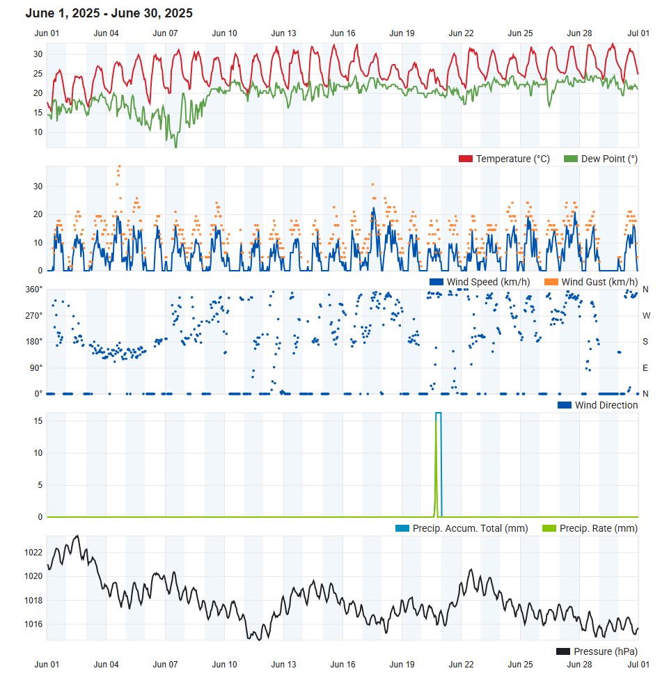
Air Temperature
| Highest Maximum | 32.8°C | 29th |
| Lowest Maximum | 24.3°C | 2nd |
| Highest Minimum | 24.9°C | 27th |
| Lowest Minimum | 14.6°C | 1st |
| Mean Maximum | 30.1°C |
| Mean Minimum | 20.8°C |
| Mean | 25.4°C |
Relative Humidity
| Highest Relative Humidity | 95% | 20th |
| Lowest Relative Humidity | 19% | 6th |
| Mean Relative Humidity | 71.9% |
Wind
| Highest Gust | 37.0km/h | 4th |
| Mean Wind Speed | 5.8km/h |
| Most Frequent Wind Direction | West Northwest |
Atmospheric Pressure
| Highest Atmospheric Pressure | 1023.4hPa | 2nd |
| Lowest Atmospheric Pressure | 1014.4hPa | 11th |
| Mean Atmospheric Pressure | 1017.8hPa |
Precipitation
| Total Rainfall During June 2025 | 22.5 mm |
| Total Rainfall Since Last 01/09 | 503.4 mm |
| Highest 24 Hour Total | 22.5 mm | 20th |
| Rain Days | 1 day |
| Thunderstorm Days | 0 days |
| Hail Days | 0 days |
Rainfall Events
| 20/6/2025 | 22.5 mm | P.M. Downpours |
June 2025 Compared to the Climate Means
| Climate Mean | June 2025 | Anomaly | |
| Mean Maximum Temperature | 28.5°C | 30.1°C | +1.6°C |
| Mean Minimum Temperature | 19.8°C | 20.8°C | +1.0°C |
| Mean Temperature | 24.2°C | 25.4°C | +1.2°C |
| Mean Relative Humidity | 70.5% | 71.9% | +1.4% |
| Mean Atmospheric Pressure | 1015.1hPa | 1017.8hPa | +2.7hPa |
| Total Rainfall | 4.1 mm | 22.5 mm | +18.4 mm |
| Total Rainfall Since Last 01/09 | 518.6 mm | 503.4 mm | -15.2 mm |
| Total Rain Days | 1 day | 1 day | / |
| Total Thunderstorm Days | 1 day | 0 days | -1 day |
| Total Hail Days | 0 days | 0 days | / |
Warmer than Average in June 2025
June was off to a comfortable start. This lasted only briefly, however, as the heat of summer quickly turned up on the 7th. From then on, temperatures were above the climatic norm of 24.2°C on 23 days out of 24. The single cooler day was the 20th, a day which brought a series of afternoon downpours to parts of the Maltese Islands, the heaviest of which struck Gozo. The 29th, a Sunday, was the warmest day last month. The temperature peaked at 32.8°C on the day. For comparison, the mean maximum temperature for June is of 28.5°C. The pre-dawn hours of the 1st day of the month were the coolest, with a minimum temperature of 14.6°C. June’s climatic mean minimum temperature of 19.8°C was exceeded by a total of 21 out of 30 nights.
Large swathes of western Europe were affected by a particularly intense heat wave, with temperature values regularly in the upper 40°Cs across Spain and Portugal. In addition to this, the entire Mediterranean basin experienced an incredible lack of wind, widespread calm sea and uninterrupted blazing sunshine for much of June. This means that transfer of heat from the Sun to the sea surface is uninterrupted. The lack of wind and waves means that the sea isn’t mixing. This leads to a build-up of heat in the topmost layer of the sea. When the sea warms up too much, marine ecosystems are negatively impacted. Several marine species are not adapted to the warmer waters and therefore will suffer from poor health if not die. The lifecycle of numerous marine species goes haywire, especially where reproduction is concerned. Furthermore, marine ecosystems (especially those in shallower waters) experience a degree of degradation. The rates of oxygen dissolved in the water will also vary more widely. Finally, some alien species find it easier to spread in warmer waters, threatening the existence of more indigenous marine life. A very high sea surface temperature inhibits nighttime cooling in air temperatures. The high sea surface temperature will also contribute to increased rates of evaporation, which in turn, will lead to increased humidity. The more humid the air is, the warmer and clammier it will feel. Early and late mist or fog patches are also products of these increased levels of humidity.
June brought with it one day of rain. Rainfall was in the form of localized downpours, over the central and northern coasts of both Malta and Gozo. Surprisingly, Gozo received the heaviest rainfall. Being the larger island, it is Malta that normally receives the most rainfall from these downpours. These clouds develop thanks to the vertical movement of columns of warm and humid air on sunny days and when the upper levels of the atmosphere are unstable due to the incursion of cold air from northern Europe. This is a process caused when the cold air in the upper levels of the atmosphere contrasts with the ground that has been well heated by the sun locally. This movement encourages the condensation of water vapor in this air and thus the formation of clouds. These showers, which affected only localized areas, lasted for a long while. Victoria, in Gozo, recorded up to 26.9 mm on that day. The national mean for the day, and also the month, was of 3.2 mm.
Rainfall Totals around the Maltese Islands in June 2025 (and since last September 1st):
Kerċem: 22.5 mm (503.4 mm)
Victoria: 26.9 mm (520.3 mm)
Marsalforn: 1.4 mm (433.2 mm)
Xewkija: 8.8 mm (371.3 mm)
Nadur: 1.2 mm (484.3 mm)
Għajnsielem: 0.0 mm (421.0 mm)
Mellieħa: 0.0 mm (375.8 mm)
Buġibba: 0.0 mm (369.9 mm)
Mġarr: 0.0 mm (450.0 mm)
Naxxar: 6.6 mm (466.6 mm)
Mosta: 0.8 mm (460.2 mm)
Dingli: 0.0 mm (569.3 mm)
Pembroke: 6.2 mm (491.8 mm)
Msida: 1.5 mm (547.8 mm)
Sliema: 1.2 mm (449.6 mm)
Valletta: 0.0 mm (457.8 mm)
Fgura: 0.0 mm (547.4 mm)
Żejtun: 0.0 mm (499.2 mm)
Żabbar: 0.0 mm (552.2 mm)
Imqabba: 0.0 mm (529.1 mm)
Siġġiewi: 0.0 mm (485.7 mm)
Żurrieq: 0.0 mm (473.4 mm)
Marsaxlokk: 0.0 mm (383.8 mm)
NATIONAL MEAN: 3.2 mm (469.2 mm)