


Air Temperature
| Highest Maximum | 34.7°C | 11th |
| Lowest Maximum | 25.8°C | 28th |
| Highest Minimum | 25.5°C | 1st |
| Lowest Minimum | 18.5°C | 30th |
| Mean Maximum | 29.6°C |
| Mean Minimum | 22.0°C |
| Mean | 25.8°C |
Relative Humidity
| Highest Relative Humidity | 94% | Numerous days |
| Lowest Relative Humidity | 35% | 11th |
| Mean Relative Humidity | 76.7% |
Wind
| Highest Gust | 38.6km/h | 15th |
| Days with Force 5 (29 – 38kph) | 6 days |
| Days with Force 6 (39 – 49kph) | 0 days |
| Days with Force 7 (50 – 61kph) | 0 days |
| Days with Force 8 (62 – 74kph) | 0 days |
| Days with Force 9 (75 – 88kph) | 0 days |
| Days with Force 10+ (89kph+) | 0 days |
| Mean Wind Speed | 5.7km/h |
| Most Frequent Wind Direction | North |
Atmospheric Pressure
| Highest Atmospheric Pressure | 1023.6hPa | 30th |
| Lowest Atmospheric Pressure | 1011.9hPa | 9th |
| Mean Atmospheric Pressure | 1018.6hPa |
Precipitation
| Total Rainfall During September2026 | 87.7 mm |
| Total Rainfall Since Last 01/09 | 87.7 mm |
| Highest 24 Hour Total | 43.7 mm | 19th |
| Rain Days | 13 days |
| Thunderstorm Days | 7 days |
| Hail Days | 0 days |
Rainfall Events
| 13/9/2026 | 0.5 mm | Isolated Light Rain; Distant Localized Thunderstorm |
| 14/9/2026 | 12.9 mm | Thunderstorm |
| 15/9/2026 | 0.3 mm | Isolated Light Rain; Distant Thunder |
| 18/9/2026 | 19.7 mm | Thunderstorm |
| 19/9/2026 | 43.7 mm | Thunderstorm |
| 20/9/2026 | 0.0 mm | Distant Localized Thunderstorm |
| 21/9/2026 | 0.0 mm | Distant Isolated Showers |
| 23/9/2026 | 0.5 mm | Distant Localized Thunderstorm |
| 25/9/2026 | 0.0 mm | Distant Isolated Showers |
| 26/9/2026 | 8.3 mm | Morning Isolated Showers; Evening Downpours |
| 28/9/2026 | 0.0 mm | Distant Isolated Light Rain |
| 29/9/2026 | 0.0 mm | Distant Isolated Light Rain |
| 30/9/2026 | 1.8 mm | Isolated Light Rain |
September2026 Compared to the Climate Mean
| Climate Mean | September 2026 | Anomaly | |
| Mean Maximum Temperature | 28.5°C | 29.6°C | +1.1°C |
| Mean Minimum Temperature | 21.6°C | 22.0°C | +0.4°C |
| Mean Temperature | 25.0°C | 25.8°C | +0.8°C |
| Mean Relative Humidity | 76.6% | 76.7% | +0.1% |
| Mean Atmospheric Pressure | 1016.7hPa | 1018.6hPa | +1.9hPa |
| Total Rainfall | 54.9 mm | 87.7 mm | +32.8 mm |
| Total Rainfall Since Last 01/09 | 54.9 mm | 87.7 mm | +32.8 mm |
| Total Rain Days | 5 days | 13 days | +8 days |
| Total Thunderstorm Days | 3 days | 7 days | +4 days |
| Total Hail Days | 0 days | 0 days | / |
September 2026: Autumn Breaks Through as Rain and Thunder Finally Return
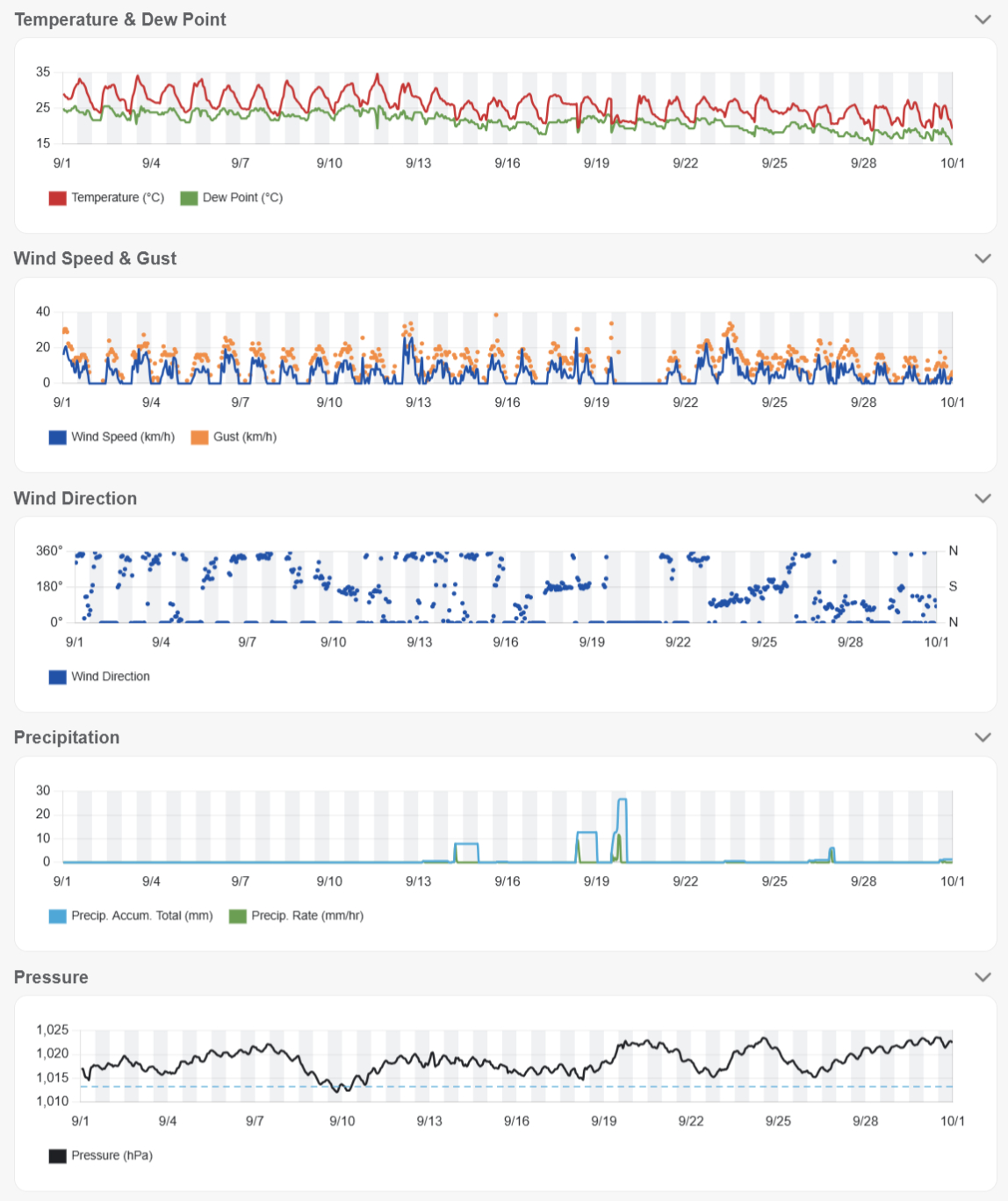
September 2026 marked a decisive change in the weather across the Maltese Islands. After an exceptionally hot and virtually rainless summer, the month finally brought the return of widespread rainfall and frequent thunderstorms. Nevertheless, summer did not disappear immediately: temperatures remained above the seasonal norm overall, particularly during the first half of the month, before noticeably cooler and more unsettled conditions became established later on.
At Kerċem, the mean air temperature for September was 25.8°C, some 0.8°C above the climatological average. The mean maximum reached 29.6°C, standing 1.1°C above normal, while the mean minimum of 22.0°C was 0.4°C above average. The stronger anomaly in daytime temperatures reflected the lingering summer warmth, even as nights gradually became more seasonable as the month progressed.
The month’s highest temperature of 34.7°C was recorded on the 11th, coinciding with very dry air that saw relative humidity fall to just 35%. This proved to be one of the final expressions of the prolonged summer heat. Soon afterwards, the weather pattern changed markedly. The lowest maximum fell to 25.8°C on the 28th, while the month’s lowest minimum of 18.5°C arrived on the 30th – an indication that autumnal cooling had finally begun. Mean relative humidity, meanwhile, stood at 76.7%, almost exactly matching the climatological average of 76.6%.
The most significant change, however, came from the return of precipitation. Kerċem recorded 87.7 mm of rain, around 60% more than the September climatological average of 54.9 mm. Even more striking was its frequency: measurable rain fell on 13 days, compared with an average of only five, while seven thunderstorm days were recorded against a climatological norm of three. September was therefore not simply wetter than normal; unsettled and convective conditions occurred much more frequently than would normally be expected.
The most significant rainfall occurred on the 19th, when Kerċem accumulated 43.7 mm in 24 hours – almost half of the month’s entire rainfall total in a single day. This formed part of a period of particularly active and locally persistent thunderstorm development over and around the Maltese Islands during the middle of the month. Other episodes produced much lighter or highly localised rainfall, illustrating the characteristically uneven distribution of early-autumn convection.
That variability is particularly evident in rainfall totals across the islands. Marsaxlokk recorded 116.0 mm and Żurrieq 112.0 mm, while Nadur reached 102.4 mm. At the other end of the spectrum, Buġibba received just 39.3 mm and Għarb 41.6 mm. The national mean stood at 75.2 mm, confirming that September was a wet month overall despite substantial differences between individual localities.
The rainfall also brought an emphatic end to one of the most remarkable dry periods of 2026. Following only 0.3 mm of rain throughout the entire meteorological summer at Kerċem, September alone delivered 87.7 mm. The transition was particularly striking after the prolonged run of summer heat and dryness: within the space of a few days, the islands shifted from persistent summer conditions to repeated episodes of showers and thunderstorms.
Winds nevertheless remained remarkably light overall. Mean wind speed was just 5.7 km/h, with northerly winds the most frequent. Only six days reached Force 5, none reached Force 6 or stronger, and the highest gust was 38.6 km/h on the 15th. The generally weak steering flow during some of the month’s convective episodes also favoured slow-moving showers and thunderstorms, allowing rainfall to become locally concentrated where cells persisted or repeatedly developed over similar areas.
Atmospheric pressure averaged 1018.6 hPa, some 1.9 hPa above normal, despite the month’s unsettled character. Pressure ranged from 1011.9 hPa on the 9th to 1023.6 hPa on the 30th. This serves as a useful reminder that early-autumn thunderstorms around the central Mediterranean do not necessarily require deep surface low pressure; sufficient atmospheric instability, moisture and local or upper-level forcing can generate significant convection even under relatively high surface pressure.
Rainfall Totals around the Maltese Islands in September2026 (and since last September 1st):
Għarb: 41.6 mm (41.6 mm)
Kerċem: 87.7 mm (87.7 mm)
Victoria: 60.6 mm (60.6 mm)
Marsalforn: 72.7 mm (72.7 mm)
Xewkija: 84.1 mm (84.1 mm)
Nadur: 102.4 mm (102.4 mm)
Għajnsielem: 74.2 mm (74.2 mm)
Mellieħa: 50.1 mm (50.1 mm)
Buġibba: 39.3 mm (39.3 mm)
Mġarr: 61.2 mm (61.2 mm)
Naxxar: 54.7 mm (54.7 mm)
Mosta: 49.2 mm (49.2 mm)
Dingli: 52.1 mm (52.1 mm)
Pembroke: 54.2 mm (54.2 mm)
Msida: 90.2 mm (90.2 mm)
Sliema: 56.8 mm (56.8 mm)
Valletta: 83.6 mm (83.6 mm)
Fgura: 87.2 mm (87.2 mm)
Żejtun: 93.3 mm (93.3 mm)
Żabbar: 79.8 mm (79.8 mm)
Imqabba: 90.6 mm (90.6 mm)
Siġġiewi: 82.8 mm (82.8 mm)
Żurrieq: 112.0 mm (112.0 mm)
Marsaxlokk: 116.0 mm (116.0 mm)
NATIONAL MEAN: 75.2 mm (75.2 mm)