Updates

For the latest updates related to the weather in the Maltese Islands. So keep yourself updated by visiting this page frequently or like our Facebook page.

Updates

STRONG WIND WARNING / TWISSIJA TA’ RIĦ QAWWI

ENGLISH/INGLIŻ

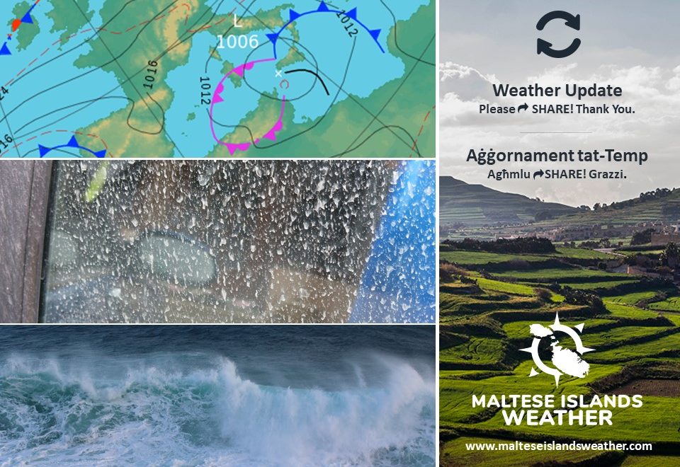
The difference between an intense low pressure system (994hPa) over the Gulf of Genoa and a ridge of high pressure (1022hPa) to our south will generate a strong Southwest wind. This strong wind warning is valid from 06:00 on Tuesday 08/12 till 09:00 on Wednesday 09/12.


Tuesday 08/12 

06:00 to 09:00 – Southwest Force 5 to 6

09:00 to 12:00 – Southwest Force 6 to 7

12:00 to 15:00 – Southwest Force 7

15:00 to 18:00 – Southwest Force 7 (with gusts of up to Force 8)

18:00 to 21:00 – Southwest Force 7 (with gusts of up to Force 8)

21:00 to 00:00 – Southwest to West Southwest Force 7 to 8 (with gusts of up to Force 9)

Wednesday 09/12

00:00 to 03:00 – West Southwest Force 8 (with gusts of up to Force 9)

03:00 to 06:00 – West Southwest Force 8 to 7 (with gusts of up to Force 9)

06:00 to 09:00 – West Southwest Force 7 to 5


The peak gusts will blow across the Maltese Islands from evening on Tuesday 08/12 till early morning on Wednesday 09/12, when they will reach Force 9 across exposed areas. The sea will be rough to very rough at times with a significant wave height of 4 meters from the Southwest in peak gusts. The swell will be a low Southwest. The map below indicates the stretch of coastline most exposed to this strong wind and rough sea. It is worth noting that a wind of this strength from the Southwest affects the channel between Malta and Gozo. There have been occasions in the past when the ferry took the longer route around Comino on days with a similar wind.

The wind will remain strong for much of the week, reaching Force 5 to 6 from the West Southwest to West Northwest at some point on all days till at least Sunday 13/12. Further warnings will be issued if necessary.


MALTI / MALTESE

Id-differenza bejn sistema ta’ pressjoni baxxa intensa (994hPa) fuq il-Golf ta’ Genoa u firxa ta’ pressjoni għolja (1022hPa) lejn in-nofsinhar tagħna se twassal għal riħ qawwi mill-Lbiċ. Din it-twissija ta’ riħ qawwi se tkun fis-seħħ minn 06:00 tat-Tlieta 08/12 sa 09:00 ta’ l-Erbgħa 09/12.


It-Tlieta 08/12 

06:00 sa 09:00 – Lbiċ Forza 5 għal 6

09:00 sa 12:00 – Lbiċ Forza 6 għal 7

12:00 sa 15:00 – Lbiċ Forza 7

15:00 sa 18:00 – Lbiċ Forza 7 (b’buffuri ta’ Forza 8)

18:00 sa 21:00 – Lbiċ Forza 7 (b’buffuri ta’ Forza 8)

21:00 sa 00:00 – Lbiċ għal Punent Lbiċ Forza 7 għal 8 (b’buffuri ta’ Forza 9)

L-Erbgħa 09/12

00:00 sa 03:00 – Punent Lbiċ Forza 8 (b’buffuri ta’ Forza 9)

03:00 sa 06:00 – Punent Lbiċ Forza 8 għal 7 (b’buffuri ta’ Forza 9)

06:00 sa 09:00 – Punent Lbiċ Forza 7 għal 5


Il-buffuri l-aktar qawwija se jaħkmu l-Gżejjer Maltin minn filgħaxija tat-Tlieta 08/12 sa kmieni filgħodu ta’ l-Erbgħa 09/12, meta dawn se jilħqu Forza 9 fl-inħawi l-aktar esposti. Il-baħar se jkun qawwi għal qawwi ħafna kultant b’mewġ għoli 4 metri mill-Lbiċ fl-aktar buffuri intensi. L-imbatt se jkun baxx Lbiċ. Il-mappa ta’ hawn taħt tindika l-inħawi tal-kosta l-aktar esposti għal dan ir-riħ qawwi u mewġ għoli. Ta’ min ngħidu li riħ Lbiċ ta’ din il-qawwa jaħkem sew il-fliegu ta’ bejn Malta u Għawdex. Kien hemm diversi okkażżjonijiet fil-passat meta l-vapur opera r-rotta minn wara Kemmuna f’riħ bħal dan.

Ir-riħ se jibqa qawwi għal bqija ta’ din il-ġimgħa, u se jilħaq Forza 5 għal 6 mill-Punent Lbiċ għal Punent Majjistru f’xi ħin matul il-jiem kollha sa minn ta’ l-anqas il-Ħadd 13/12. Aktar twissijiet jinħarġu jekk jinħass il-bżonn.


Updates

Unstable weather to continue / It-temp instabbli se jkompli

ENGLISH/INGLIŻ

Latest maps reveal that instable weather is likely to continue till at least the end of this week, as successive areas of low pressure will be moving across the central Mediterranean. Though nothing too intense is expected, we’re dedicating an update to describe exactly what we’re expecting the weather to be like in the coming days. Till Sunday 13/12, it’s likely we’ll get at least one isolated shower at some point on all days. The wind will also reach at least Force 6 at some point on all days till then. The wind direction will continuously alternate between the West Southwest and West Northwest in the coming days. Whilst no events of excessive rain are likely, it is worth knowing that any isolated showers over the course of this week may be heavy, thundery and with hail at times. Any hail should be small in size. It is not possible to give any indications on when rain is more likely so early. This information will be given on a day-by-day basis. The same goes for wind speed. Decisions on whether a warning should be issued or not will be taken on a daily basis. So far, it appears that the strongest it will be is Force 6/7.


MALTI / MALTESE

L-aħħar mapep jiżvelaw li t-temp instabbli se jkun qed ikompli sa minn ta’ l-anqas tmiem din il-ġimgħa, kaġun ta’ numru ta’ sistemi ta’ pressjoni baxxa li se jkun qed isegwu lil xulxin, waħda wara l-oħra. Għalkemm mhux qed nistennew maltemp intens iżżejjed, qed niddedikaw dan l-aġġornament biex ninfurmawkom dwar x’għandna nistennew rigward temp għal jiem li ġejjin. Jidher li għandna nistennew sa minn ta’ l-anqas ħalba waħda ta’ xita iżolata kuljum sa nhar il-Ħadd 13/12. Sa nhar il-Ħadd 13/12 ukoll, ir-riħ se jilħaq minn ta’ l-anqas Forza 6 f’xi ħin fil-jiem kollha. Ir-riħ se jkun qed ivarja kontinwament fid-direzzjoni bejn Punent Lbiċ u Punent Majjistru għal dawn il-jiem. Għalkemm l-ebda episodju ta’ xita eċċessiva ma jidher li se jaħkimna, sew tkunu tafu li l-ħalbiet tax-xita iżolati jistgħu jkunu qawwijin, bir-ragħad u silġ kultant. Is-silġ għandu jkun ta’ daqs żgħir. Mhux possibli li nipprevjenu bl-eżatt il-ħinijiet li fihom se tkun qed tagħmel ix-xita. Dak jingħad ta’ kuljum fl-aġġornament għal l-għada.  L-istess nistgħu ngħidu għal qawwa tar-riħ. Deċiżjonijiet dwar jekk tinħariġx twissija jew le jittieħdu ta’ kuljum. Sa issa jidher li aktar li se jkun qawwi r-riħ huwa Forza 6/7.

Updates

This week: Remaining windy

It looks like we’re in for a week of strong wind and showery weather. Areas of low pressure will prevail over the Gulf of Genoa. Meanwhile, high pressure will stands its ground to our south. This meteorological setting will guarantee another week of instability. The wind will be from the West to West Northwest on all days. It will also reach at least Force 6 at some point on all days. Whilst maps do not show persistent widespread rainfall on any day, it’s likely that the series of isolated showers expected throughout the week will reach all corners of our islands at some point or another. It’s also the first week so far this autumn with temperatures not expected to reach the 20°C mark on any day. We’re looking at daytime highs of 16°C to 19°C. Night time lows will be in the region of 11°C / 12°C on most nights. Temperatures will feel colder in strong wind.

Updates

Two showery days / Jumejn b’ħalbiet tax-xita

ENGLISH/INGLIŻ

A zone of instability associated with a low pressure system over the Gulf of Genoa will be traversing the central Mediterranean on Wednesday 02/12 and Thursday 03/12. This will mark the swift return of showery weather to the Maltese Islands. We’re expecting two main showery episodes, one around noon on Wednesday and the other around noon on Thursday, with a likely break in between. Any showers may be heavy, thundery and with hail at times. Chances of severe weather are negligible. We’re not expecting any excessive precipitation. The wind will a Southwest Force 4/5 on Wednesday and a Southwest to West Force 5/6 on Thursday.


MALTI / MALTESE

Zona ta’ instabilita’ abbinata ma’ sistema ta’ pressjoni baxxa fuq il-Golf ta’ Ġenoa se tgħaddi minn fuq iċ-ċentru tal-Mediterran nhar il-Erbgħa 02/12 u l-Ħamis 03/12. Din se ġġib magħha aktar ħalbiet tax-xita, wara jumejn ta’ bnazzi. Qed nistennew żewġ episodji ta’ xita separati, waħda madwar nofsinhar ta’ l-Erbgħa u l-oħra madwar nofsinhar tal-Ħamis, bi probabilita tajba ta’ waqfa bejniethom. Ix-xita tista tkun qawwija, bir-ragħad u bis-silġ kultant. Ir-riskju ta’ maltemp sever huwa negliġibli. Mhux qed nistennew ammonti kbar ta’ xita. Ir-riħ se jlaħħaq Forza 4/5 mill-Lbiċ nhar il-Erbgħa u Forza 5/6 mill-Lbiċ għal Punent nhar il-Ħamis.

Updates

This week: December off to a wet start

This week is likely to bring further rainy days. This week should be off to a dry start, with both Monday 30/11 and Tuesday 01/12 promising to be dry and with long periods of sunshine. A low pressure system from over the Gulf of Genoa will drench the Maltese Islands in showers and thunderstorms on both Wednesday 02/12 and Thursday 03/12. Friday 04/12 could be a brief break from the rain, but a second low pressure system is expected to bring further rain to our shores at the weekend. The wind will be moderate, and from the West to Southwest, on the majority of days. One of two days could be windy. Saturday 05/12 or Sunday 06/12 are likely to be one of these. Temperatures will continue to be very mild, however. Daytime highs will be in the region of 18°C to 20°C. Night time lows will be of 13°C / 14°C. Sunday 06/12 may be an exception to this, with noticeably colder temperatures possible on that day.

Updates

A weekend of instability / Tmiem il-ġimgħa ta’ instabilita’

ENGLISH/INGLIŻ

A low pressure system of north African origin will move across the central Mediterranean this weekend. Whilst it will bring unsettled weather on both Saturday 28/11 and Sunday 29/11, the weather conditions will be noticeably different between the two days.

Saturday 28/11: We’re expecting a variably to mostly cloudy sky with the possibility of a few isolated showers. Rainfall amounts will be low. The wind from the Southeast will increase to Force 5/6 at times 7 on occasion during the day. It will slowly shift Southwest. Being of north African origin, the low pressure system will bring abundant airborne fine desert sand to our skies. As a result, we’re expecting the air to be hazy at times. Any rain will deposit copious amounts of desert sand too.

Sunday 29/11: We’re expecting a partly to variably to mostly sky with the possibility of a few isolated showers. Cooler air from the north will reach us at some point during the day. It will likely clash with the warm and humid air brought about by the strong southeasterly wind on the previous day. This may lead to the formation of a thunderstorm with heavy rain, although this cannot be confirmed just yet. More details about this will be given as the situation develops. In the event of a thunderstorm, rainfall amounts may be generous. The Southwest wind will continue reaching Force 5/6 throughout the day on Sunday, as it gradually shifts Northwest. This will clear away the airborne fine desert sand. In the event of a thunderstorm, the rain will be clean.

Fine weather will return to the Maltese Islands on Monday 30/11, with mainly sunny or partly cloudy skies being anticipated. The wind will gradually die down.


MALTI / MALTESE

Sistema ta’ pressjoni baxxa minn l-Afrika ta’ fuq se tgħaddi minn fuq iċ-ċentru tal-Mediterran fi tmiem din il-ġimgħa. Filwaqt li din se ġġib magħha maltemp kemm is-Sibt 28/11 kif ukoll il-Ħadd 29/11, il-kundizzjonijiet meteoroloġiċi se jvarjaw kemmxejn minn jum għal ieħor.

Is-Sibt 28/11: Nistennew sema varjabbilment għal biċċa l-kbira msaħħab bil-possibilita ta’ ftit ħalbiet iżolati tax-xita. L-ammont ta’ xita se jkun baxx. Ir-riħ mix-Xlokk se jżid għal Forza 5/6 kultant 7 f’xi ħinijiet matul il-jum. Aktar tard, ir-riħ jibda jdur bilmod Lbiċ. Peress li dan il-maltemp se jkun oriġina fuq id-deżert, l-ajru se jġorr miegħu ramel fin lejna. Riżultat ta’ dan, l-arja se tkun imdaħħna. Ix-xita li tagħmel se tkun tal-ħamrija.

Il-Ħadd 29/11: Nistennew sema ftit jew varjabbilment imsaħħab bil-possibilita ta’ ftit ħalbiet iżolati tax-xita. Arja friska mit-tramuntana se tilħaqna f’xi ħin matul il-jum. Din mistennija li toħloq kuntrast qawwi ma’ l-arja sħuna u umda li se jkun ġab miegħu r-riħ mix-Xlokk fil-jum ta’ qabel. Dan il-kuntrast jista jwassal għal maltempata bir-ragħad b’xita qawwija. Dan għadu ma jistax jiġi kkonfermat għal issa, pero. Aktar dettalji jingħataw kif tiżviluppa s-sitwazzjoni. F’każ ta’ maltempata bir-ragħad għandna nistennew ammonti ta’ xita ġenerużi. Ir-riħ mill-Lbiċ se jibqa jilħaq Forza 5/6 matul il-jum kollu tal-Ħadd, filwaqt li jdur bilmod Majjistral. Dan se jnaddaf l-arja mir-ramel fin. F’każ ta’ maltempata bir-ragħad, ix-xita tkun nadifa.

Temp sabiħ jirritorna lejn il-Gżejjer Maltin nhar it-Tnejn 30/11, b’sema l-biċċa l-kbira xemxi jew ftit imsaħħab. Ir-riħ jonqos bilmod ukoll.

Updates

More days with rain / Aktar jiem bix-xita

ENGLISH/INGLIŻ

Rainfall totals over the past few days have ranged from a poor 9.2 mm in Valletta to a more generous 33.8 mm in Għarb.

Now, according to the latest weather maps, the meteorological situation across the central Mediterranean will remain unstable for longer than initially expected. A prevalent easterly wind will continue advecting moist air towards our area. This will continue to clash with the colder air brought about by last weekend’s low pressure system. As a result, showers will continue developing around our islands. Whilst rain is possible any time, the next round of showers is likely from later in the day on Wednesday 25/11 till early in the day on Friday 27/11. Once again, although some showers will be heavy and with hail at times, they will be relatively isolated. As a result, they will only affect a handful of localities at a time. Meanwhile, a low pressure system will form over Algeria and migrate towards the central Mediterranean. This will affect us over the weekend, with the possibility of a strong to very strong wind from the South to Southwest. This separate system may bring further rain on Saturday 28/11 and Sunday 29/11. More information about these will be given in a separate update.


MALTI / MALTESE

It-total ta’ xita fl-aħħar jiem varja minn livell fqir ta’ 9.2 mm fil-Belt Valletta sa ammont aktar ġeneruż ta’ 33.8 mm fl-Għarb.

Issa, skont l-aħħar aġġornament tal-mapep tat-temp, jidher li s-sitwazzjoni meteoroloġika fiċ-ċentru tal-Mediterran se tibqa nstabbli għal żmien itwal minn li kien mistenni. Riħ persistenti mill-Lvant se jkompli jġib miegħu arja umduża lejna. Din se tkompli tiltaqgħa ma’ arja kiesħa mit-tramuntana li nġabet mis-sistema ta’ pressjoni baxxa li ħakmitna matul tmiem il-ġimgħa li għaddiet. Riżultat ta’ dan nistennew li jkompli jiżviluppa aktar maltemp madwarna. Filwaqt li x-xita tibqa possibbli minn ħin għal ieħor, jidher li l-perjodu li jmiss ta’ xita se jmissna l-aktar bejn tard l-Erbgħa 25/11 u kmieni l-Ġimgħa 27/11. Għal darb’oħra, għalkemm xi ħalbiet tax-xita se jkunu qawwijin u bis-silġ kultant, dawn se jkunu relattivament iżolati. Għalhekk, dawk se jaffetwaw ftit lokalitajiet kull darba. Sadattant, sistema ta’ pressjoni baxxa se tiżviluppa fuq l-Alġerija u testendi lejn iċ-ċentru tal-Mediterran. Din se taffetwana fi tmiem il-ġimgħa, meta se jkun hemm potenzjal ta’ riħ qawwi jew qawwi ħafna minn Nofsinhar għal Lbiċ. Din l-istess sistema taf iġġib magħha wkoll aktar xita matul il-jiem tas-Sibt 28/11 u l-Ħadd 29/11. Aktar dettalji dwar dawn ta’ l-aħħar jinħarġu f’aġġornament separat.

Updates

This week: It should rain on most days

A low pressure system over the central Mediterranean will remain stationary for much of this week, as local meteorological conditions will be ideal to sustain it. We expect it to rain at some point on all days till at least Friday 27/11. Any showers may be heavy, thundery and with hail at times. This doesn’t mean we won’t be seeing the sun, however. Most days will feature several hours of mainly sunny or partly cloudy skies. The rain over the course of this week could help salvage an otherwise very dry November. Temperatures this week will be relatively stable, with 19°C to 21°C highs and 13°C to 15°C lows. Some showers may cause temperatures to dip a bit lower momentarily in areas. Winds from an easterly quadrant will be dominant on most weekdays, before it’s likely we’ll see a shift to a more westerly direction by the weekend. The wind will be mainly moderate in strength, not exceeding Force 5, on weekdays. It could strengthen over the weekend. We’re not certain about this just yet though.

Updates

Rain for the weekend / Tmiem il-ġimgħa bix-xita

ENGLISH/INGLIŻ

The second instability for this week will be affecting the Maltese Islands over the weekend. A low pressure system over the Gulf of Genoa will migrate towards the central Mediterranean on Saturday 21/11, intensifying as it does so. This will bring colder air from the north with it. Meanwhile, a southerly current will advect warm and humid across our region. The two will clash to develop and sustain a mass of rain clouds that will remain stationary over the central Mediterranean until at least Monday 23/11. We’re expecting a series of showers which will be heavy and also possibly thundery at times over the Maltese Islands from early on Saturday through to late on Monday. Although rainfall totals could be substantial, we’re not expecting very large amounts of rain in a short space of time. Flooding will obviously still be possible in the usual low-lying areas. The wind, which will start off from the West to Southwest, and veer Southeast to East later on Saturday, will reach up to Force 7 over these three days. No severe weather is expected.


MALTI / MALTESE

It-tieni mewġa ta’ instabbilita għal din il-ġimgħa se tlkun qed taffetwa l-Gżejjer Maltin fi tmiem il-ġimgħa. Sistema ta’ pressjoni baxxa fuq il-Golf ta’ Ġenoa se tintensifika filwaqt li testendi lejn iċ-ċentru tal-Mediterran nhar is-Sibt 21/11. Din se ġġib magħha arja kiesħa minn naħa ta’ fuq ta’ l-Ewropa. Fl-istess waqt, kurrenti minn nofsinhar se jimbuttaw arja sħuna u umda lejn ir-reġjun tagħna. Il-kuntrast ta’ bejn dawn se joħloq u jsostni massa ta’ sħab tax-xita li se tkun stazzjonarja fuq iċ-ċentru tal-Mediterran sa minn ta’ l-anqas nhar it-Tnejn 23/11. Nistennew serje ta’ ħalbiet tax-xita li se jkunu qawwijin u anke possibilment bir-ragħad fil-Gżejjer Maltin minn kmieni s-Sibt sa tard it-Tnejn. Għalkemm l-ammont ta’ xita jaf ikun sostanzzjali, ma jidhirx se jkollna ammonti kbar ta’ xita f’daqqa. Ovvjament, wieħed għandu jistenna li jinġabar xi ilma fl-inħawi tas-soltu. Ir-riħ, li mill-Punent għal Lbiċ se jaqleb Xlokk għal Lvant aktar tard is-Sibt, se jkompli jilħaq Forza 7 matul dawn it-tlett ijiem. Mhux qed nistennew maltemp sever.

Updates

A change in weather / Taqliba fit-temp

ENGLISH/INGLIŻ

The anticyclone that has dominated the meteorological scene across the Mediterranean over the past weeks has dissolved. This will make it possible for low pressure systems from over the Atlantic to reach our shores. At least two successive storm systems will affect the Maltese Islands over the course of this week, resulting in a lengthy unstable spell. The first of these will reach us in the early hours of Tuesday 17/11. We’re expecting a cold front to bring a series of showers possibly heavy, thundery and with small hail at times across our islands. Rainfall amounts should not be exceptional, but they should still be sufficient enough to start easing the drought. Whilst rain is possible at any time, the heaviest rain is likely to occur in the morning and early afternoon. The temperature will be appreciably cooler, with the daytime high unlikely to exceed 20°C. The Southwest wind will veer West to West Northwest and reach Force 5/6 at times during the day. The risk of any severe weather is very low. We will provide you with updates on the meteorological situation for the rest of the week as the days progress.


MALTI / MALTESE

L-antiċklun li ddomina s-sitwazzjoni metereoloġika madwar il-Mediterran għal dawn l-aħħar ġimgħat sfaxxa. Dan se jagħmilha possibbli biex sistemi ta’ maltemp minn fuq l-Atlantiku jilħquna. Minn ta’ l-anqas żewġ sistemi ta’ pressjoni baxxa se jaffetwawna wara xulxin matul din il-ġimgħa, u se jwasslu għal perjodu nstabbli daqsxejn fit-tul. L-ewwel minn dawn se tilħaqna fis-siegħat bikrijin tat-Tlieta 17/11. Qed nistennew li front kiesaħ iġib miegħu sensiela ta’ ħalbiet tax-xita li jistgħu jkunu qawwijin, bir-ragħad u anke b’xi silġ zgħir kultant madwar il-gżejjer tagħna. L-ammont ta’ xita mhux mistenni jkun wieħed eċċezzjonali, pero’ mistenni jkun biżejjed biex jibda jtaffi n-nixfa li hemm madwar il-Gżejjer Maltin. Filwaqt li x-xita hija possibbli minn ħin għal ieħor, jidher li l-aqwa tagħha għandu jkun matul filgħodu u kmieni wara nofsinhar. It-temperatura wkoll se tkun aktar friska, bl-ogħla ma taqbiżx l-20°C. Ir-riħ mill-Lbiċ se jdur kemmxejn u jsir Punent għal Punent Majjistru u jilħaq Forza 5/6 kultant matul il-jum. Ir-riskju ta’ maltemp sever huwa baxx ħafna. Matul il-jiem li ġejjin se nkunu qed inżommukhom aġġornati bl-aħħar żviluppi rigward is-sitwazzjoni tat-temp.