Updates

For the latest updates related to the weather in the Maltese Islands. So keep yourself updated by visiting this page frequently or like our Facebook page.

Updates

This week: The first rain

An unstable week lies ahead for the Maltese Islands. The week should be off to a stormy start, with thunderstorms being possible on Monday. Further isolated showers will be possible on all days till Thursday 05/09. The weather situation will improve substantially for the weekend, with clear skies expected on all three last days of the week. A strong wind will characterise most days, as the Maltese Islands will be caught up in between low pressure over the eastern Mediterranean and high pressure over the western Mediterranean. The wind will be mainly from the West Northwest. The Maltese Islands will enjoy temperatures which are normal for this time of year. Highs will decrease gradually over the course of this week, starting off at 31 C on Monday 02/09 and cooling down to 28 C by Sunday 08/09. Nights will see lows decreasing from 24 C to 22 C. Accumulations may reach an average of 25 mm over the course of this week. Monday 02/09 will be the wettest day of the week.

Updates

Overnight thunderstorm? / Maltempata bir-ragħad billejl?

As forecast earlier, more thunderstorms will be forming across the central Mediterranean throughout the rest of Sunday 01/09 and much of Monday 02/09. Intense thunderstorms are currently affecting Tunisia. These are set to move slowly east, losing strength as they do so. They could reach the Maltese Islands at night. If they do affect us, they will be much weaker than they are at the moment. As a result, only a normal thunderstorm is possible. The chance of rain is highest from midnight till 06:00 on Monday 02/09. If they do affect us, expect rain which will be heavy, thundery and blustery at times. If the thunderstorm misses us, expect some isolated showers. Total rainfall may vary from a meagre 2.5 mm (in the event of isolated showers) to a decent 25 mm (in the event of a thunderstorm). As things stand, we are expecting a thunderstorm to reach us. Upper level winds are blowing towards us. The sea is also warm enough to sustain thunderstorms. The situation is being monitored continuously. Updates will be issued when and if necessary.

Kif bassarna aktar kmieni, aktar maltempati bir-ragħad se jiżviluppaw madwar iċ-ċentru tal-Mediterran matul il-bqija tal-Ħadd 01/09 u l-biċċa l-kbira tat-Tnejn 02/09. Maltempati bir-ragħad b’saħħithom qed jolqtu lit-Tuneżija bħalissa. Dawn se jersqu lejn il-lvant bilmod fis-siegħat li ġejjin, filwaqt li jitilfu mis-saħħa tagħhom fil-proċess. Għandhom jaħkmuna billejl. Jekk dawn jaħkmuna, dawn se jkunu aktar dgħajfa minn li huma bħalissa. Għalhekk, nistennew biss maltempata normali. Iċ-ċans ta’ xita se jkun l-ogħla minn nofsillejl sa 06:00 tat-Tnejn 02/09. Jekk jaħkmuna, stennew xita li se tkun qawwija, bir-ragħad u mirjieħa f’xi ħinijiet. Jekk il-maltempata bir-ragħad taqbiżna, stennew biss xi ħalbiet iżolati tax-xita. It-total ta’ xita jista jvarja minn 2.5 mm (jekk jaħkmuna ħalbiet iżolati tax-xita biss) sa 25 mm (jekk tmissna maltempata bir-ragħad). Kif inhuma l-affarijiet, qed nistennew li taħkimna l-maltempata bir-ragħad. Ir-riħ fil-livelli għoljin ta’ l-atmosfera qed jimbuttaw il-maltemp lejn il-Gżejjer Maltin. Il-baħar huwa sħun biżejjed biex jiffavorixxi l-iżvilupp ta’ maltemp polska-ed.com. Is-sitwazzjoni qed tiġi ssorveljat kontinwament. Aġġornamenti se jsegwu meta u jekk ikun hemmm bżonn.

Updates

The first thunderstorms / L-ewwel maltempati bir-ragħad

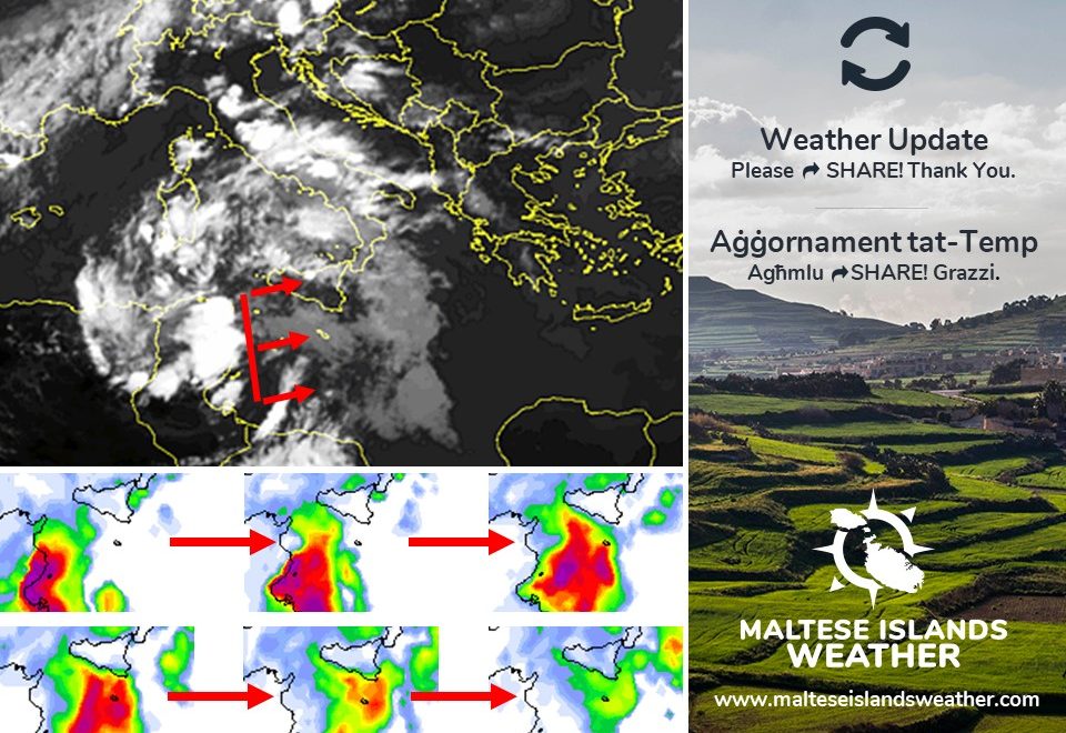
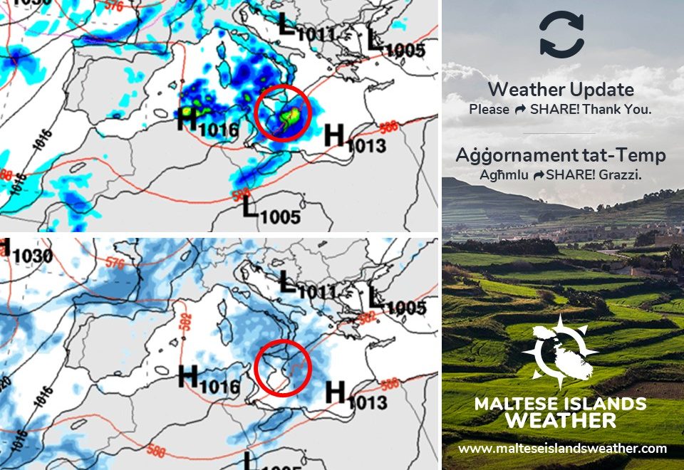
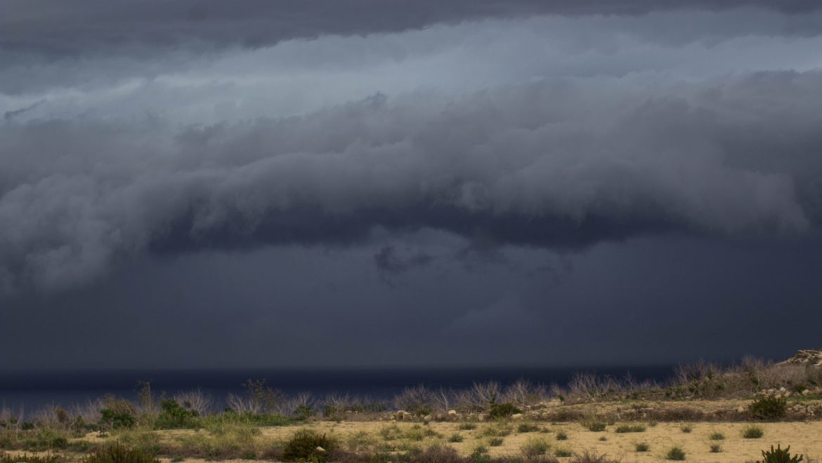
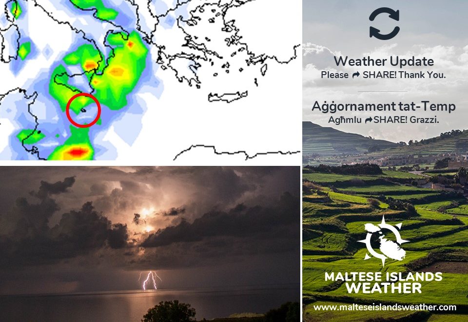
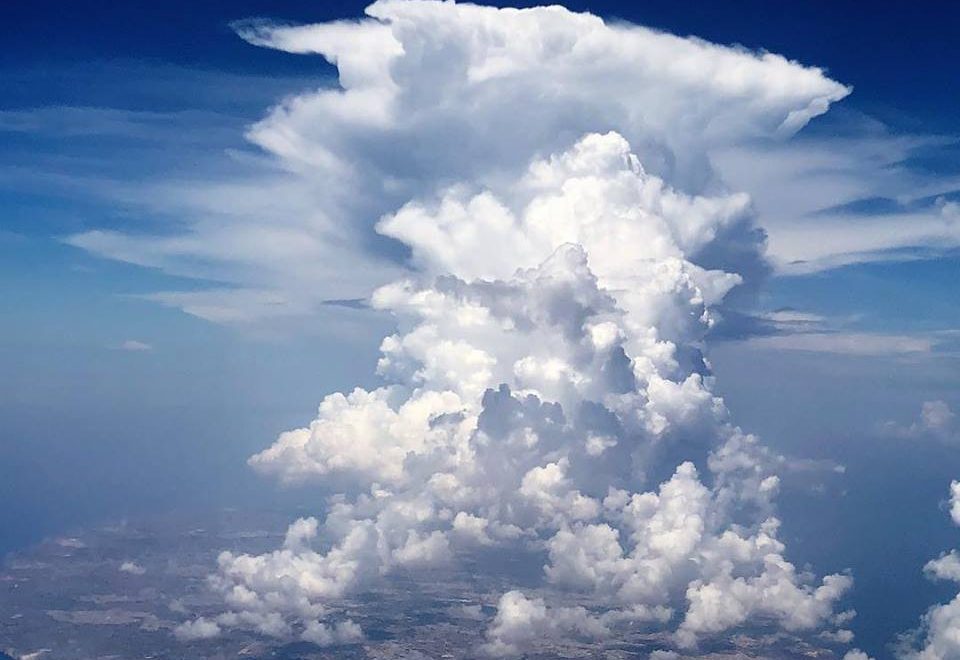
Numru ta’ fronti ta’ pressjoni baxxa se jgħaddu minn fuq iċ-ċentru tal-Mediterran matul il-ġimgħa li ġejja. Dawn se jġibu magħhom mewġa ta’ instabbilta’ lejn il-Gżejjer Maltin. F’dan l-aġġornament se niddiskutu l-potenzjal ta’ temp instabbli nhar il-Ħadd 01/09 u t-Tnejn 02/09. Il-mudelli tat-temp kollha jaqblu li maltempata bir-ragħad iżolata se tifforma qribna f’xi ħin nhar il-Ħadd 01/09. Wħud minn dawn il-mudelli qed jgħidu li din se tmissna. Oħra jidhru li għadhom indeċiżi dwar dan. Xi ftit minnhom jindikaw li din se taqbiżna. Maltempati bir-ragħad daqshekk kmieni fl-istaġun huma dinamiċi, u biex tgħid bi preċiżjoni sħiħa fejn se jaħkmu huwa kważi impossibli. Jekk maltempata bir-ragħad iżolata taffetwana nhar il-Ħadd 01/09, din tkun wara nofsinhar jew filgħaxija. Din iddum għal ħin qasir, pero taf tkun qawwija u mirjieħa. Barra minn hekk, mhux il-Gżejjer Maltin ikunu affetwati. Aktar dettalji dwar dan ikunu ppublikati kmieni l-Ħadd 01/09. Iċ-ċans ta’ xita nhar it-Tnejn 02/09 huwa ogħla. Il-maġġoranza tal-mudelli jgħidu li ħalbiet tax-xita li jistgħu jkunu qawwijin u bir-ragħad kultant jistgħu jaffetwaw lill-Gżejjer Maltin matul il-jum kollu. Dawn għandhom ikunu aktar mifruxin. Għalhekk, aktar lokalitajiet ikunu affetwati. Aktar dettalji dwar dan jinħarġu tard il-Ħadd 01/09. Is-sitwazzjoni tat-temp se tkun issorveljata regolari, u aġġornamenti se jsegwu meta u jekk ikun hemm il-bżonn.

Rigward riħ, dan se jibqa ħafif u varjabbli sa tard it-Tnejn 02/09, qabel ma jdur Majjistral filgħaxija. Ir-riħ imbagħad se jibqa mill-Majjistral għal-Punent fit-tul. It-temperaturi massimi mistennija li jibdew jinżlu taħt it-30 C minn nhar it-Tlieta 03/09 ‘il quddiem.

Successive troughs of low pressure will be traversing across the central Mediterranean over the course of next week. These will bring a wave of instability to the Maltese Islands. In this update, we will discuss the potential bad weather on Sunday 01/09 and Monday 02/09. All weather models agree that an isolated thunderstorm will form close to the Maltese Islands at some point on Sunday 01/09. Some models are suggesting that this will affect us. A few others are still undecided. Others indicate that it will miss us. Thunderstorms so early in the season are dynamic, and pointing out exactly where they will affect is almost impossible. If an isolated thunderstorm does affect us on Sunday 01/09, this will be in the afternoon or evening. It would be brief, but potentially heavy and blustery. Furthermore, not all of the Maltese Islands would be affected. Further details about this will be issued early on Sunday 01/09. The chance of rain on Monday 02/09 is higher. Most models indicate that rain showers which may be heavy and thundery at times could affect the Maltese Islands throughout the day. These would be more widespread. Therefore, a larger area of the Maltese Islands would be affected. Further details about this will be issued later on Sunday 01/09. The situation will be constantly monitored, and updates will be issued when and if necessary.

With regards to the wind, it will remain light and variable till late on Monday 02/09, before turning Northwest in the evening. It will continue blowing from the Northwest to West in the long-term. Maximum temperatures should start dipping to below 30 C from Tuesday 03/09 onward.

Updates

The first rain / L-ewwel xita

The Maltese Islands were affected by the very first rain of the season this morning. It was not much, but at least it is an indication that the meteorological situation is changing. Typical September weather is here. Apart from rain, that means hot temperatures coupled with high humidity. This combination could make the air feel suffocating at times. The weather will improve substantially over the next two days, allowing for some hours of bright sunshine. The rain returns on Sunday 01/09, as an area of low pressure will settle over the central Mediterranean. This time, the rain is expected to come in heavier amounts. It will also last throughout the first half of next week. This will be accompanied by moderate to strong winds from the Southeast (on Sunday 01/09) to Northwest (on Monday 02/09 and Tuesday 03/09). Details about how the rainfall will affect us, and which locations will be the wettest, will be made available over the next few days.

Il-Gżejjer Maltin intlaqtu minn l-ewwel xita ta’ l-istaġun dalgħodu. Ma kinetx ħafna, pero s-sinjali li t-temp qiegħed jinbidel bdew jidhru. Temp tipiku ta’ Settembru wasal ukoll. Apparti minn xita, dan ifisser temperaturi sħana u livelli għoljin ta’ umdita. Din il-kumbinazzjoni tista twassal biex l-arja tinħass soffokanti. Is-sitwazzjoni tat-temp se taqleb għal-aħjar fil-jumejn li ġejjin, u b’hekk ikollna siegħat twal ta’ xemx. Ix-xita ser tirritorna nhar il-Ħadd 01/09, hekk kif arja bi pressjoni baxxa se testendi u tistrieħ fuq iċ-ċentru tal-Mediterran ed-hrvatski.com. Din id-darba, x-xita mistennija tiġi f’ammonti akbar. Se ddum ukoll għal-ewwel nofs tal-ġimgħa li ġejja. Din se tkun akkumpanjata minn riħ moderat għal-qawwi mix-Xlokk (il-Ħadd 01/09) għal-Majjistral (it-Tnejn 02/09 u t-Tlieta 03/09). Dettalji dwar kif ix-xita se taffetwana, u liem lokalitajiet se jkunu l-aktar milquta, se tinħareġ fil-jiem li ġejjin.

Updates

Preparing for the first rain / Nippreparaw għal-ewwel xita

The first widespread rain of the season could affect the Maltese Islands at some point next week. Take advantage of the fine weather and dedicate some time to prepare your home for the rain! Some points:

– Fix any cracks in the walls and roof
– Check to see if your roof’s coating needs to be resealed
– Take a look at your gutters to make sure that they drain well
– Check indoors for any signs of leakage
– Make sure that doors and windows seal properly (especially wooden ones as they tend to contract in summer)
– Clear any gutters that take water away from your home
– Clear any debris around your home to prevent flooding and damage in strong wind
– Clean wells
– Prepare a place to shelter animals

Write other relevant advise as comments. Thanks!

Detailed update with all the details about any bad weather will be issued in due course.

L-ewwel xita mifruxa tas-sena tista taffetwa lill-Gżejjer Maltin f’xi waqt matul il-ġimgħa li ġejja. Ħudu vantaġġ tat-temp sabiħ u ddedikaw xi ftit ħin biex tippreparaw id-dar tagħkom għax-xita! Xi punti:

– Iċċekjaw il-ħitan u soqfa għal xi xquq
– Araw jekk hemmx bżonn tirranġaw il-membrane ta’ fuq il-bejt
– Araw li l-katusi u mwieżeb mhumiex miżduda
– Araw li ma hemmx minn fejn jidħol l-ilma
– Iċċekjaw li l-bibien u twieqi jingħalqu sew (speċjalment jekk ta’ l-injam, għax fis-sajf jinxfu)
– Naddfu l-ġnien jew bitħa minn ħaxix, weraq etc … biex tevitaw li jinġemgħa l-ilma
– Naddfu l-bjar
– Preparaw post fejn jistkennu l-annimali

Iktbu avviżi oħra relevanti bħala kummenti. Grazzi!

Aġġornamenti dettaljati rigward maltemp jinħarġu meta jkun hemm bżonn.

Updates

When is the first rain? / Meta ġejja l-ewwel xita?

We have said several times over the past week, that the first rain may drench the Maltese Islands towards the end of August. Are we still expecting a stormy end to the month? When is the first rain? It is still too early to confirm, but the latest maps indicate that rain showers or thunderstorms are becoming increasingly more possible at some point next week. A low pressure system will be moving across Tunisia and Sicily in the last days of August. If this extends south enough, some rain might indeed reach the Maltese Islands. This low pressure system will affect Tunisia and Sicily from Tuesday 27/08 till Saturday 31/08. If it affects the Maltese Islands, it could be on any of these days. It is also still too early to start talking about potential accumulations. More details will be posted once available.

Għidna kemm il-darba matul din l-aħħar ġimgħa, li l-ewwel xita tista xxarrab il-Gżejjer Maltin lejn l-aħħar ta’ dan ix-xahar. Għadna nistennew tmiem bil-maltemp għal dan ix-xahar? Meta se tkun l-ewwel xita? Għadu kmieni wisq biex wieħed jikkonferma, pero l-aħħar mapep jindikaw li ċ-ċans ta’ ħalbiet tax-xita jew maltempati bir-ragħad xi darba l-ġimgħa li ġejja qiegħed kull ma jmur jiżdied. Sistema ta’ pressjoni baxxa se tkun għaddejha minn fuq it-Tuneżija u Sqallija fl-aħħar jiem ta’ Awwissu. Jekk din tersaq l-isfel biżejjed, taf tmiss lill-Gżejjer Maltin ukoll. Din is-sistema ta’ pressjoni baxxa se taffetwa lit-Tuneżija u Sqallija mit-Tlieta 27/08 sas-Sibt 31/08. Jekk taffetwa lill-Gżejjer Maltin, tista tagħmel ix-xita f’xi waħda minn dawk il-jiem. Għadu kmieni wisq biex nitkellmu dwar kemm nistgħu nistennew xita. Aktar dettalji jinħarġu meta jkollna.

Updates

This week: Anticyclone to weaken

The Maltese Islands will remain covered by high pressure this week. This high pressure will be weaker than recently, however. It will be far too weak for plumes of very hot air from north Africa to reach us. On the other hand, it will be strong enough to keep low pressure systems at bay. The Maltese Islands will enjoy temperatures which are normal for this time of year. Highs will be in the region of 30 C to 32 C, while lows will be of 22 C to 24 C. Levels of humidity will be relatively high, causing the air to feel heavy and clammy. The sky will be mainly sunny or partly cloudy, with the ‘għarixa’ expected to characterise all days this coming week. No rain is anticipated this week. Winds will be light and variable.

Updates

Stable weather for now / Temp stabbli għal issa

The central Mediterranean will continue to find itself under the influence of a weak area of high pressure for now. This weak area of high pressure will be enough to maintain stable weather conditions across our region. Just as we have maintained for weeks, no further heat spells or heat waves are expected locally this summer. This is because the high pressure covering the central Mediterranean is not strong enough to support the northward extension of hot plumes from north Africa. Simultaneously, this high pressure is strong enough to prevent low pressure systems from penetrating the central Mediterranean. As a result, the Maltese Islands will enjoy stable weather conditions. This will be the case for the coming week. Temperatures will be at around average for this time of year, with highs of 29 C to 32 C and lows of 22 C to 24 C. The wind will be mainly light. An interesting phenomenon taking place around us at this time of year is the ‘għarixa ta’ Santa Marija’. This term refers to the partly cloudy sky which starts to characterise our weather by mid-August. These cumulus clouds normally start forming in the week after Santa Marija, hence their name. The appearance of these cumulus clouds indicates the presence of weak high pressure across our region. They are formed by the upward convection of columns of warm, moist air on sunlit days. This leads to the condensation of water vapour and thus the formation of these clouds. It is a process triggered by a clash between cooler air from the north and the warm sea/land locally. If the process starts in the morning, the clouds could reach substantial sizes by later in the day. In this case, a little rain may occur. The clouds dissipate by the evening, as they stop receiving energy from the sun. No rain is anticipated this week.

Iċ-ċentru tal-Mediterran se jkompli jsib ruħu taħt l-influwenza ta’ roqgħa dgħajfa ta’ pressjoni għolja għal issa. Din ir-roqgħa dgħajfa ta’ pressjoni għolja se tkun biżejjed biex tassigura temp stabbli fir-reġjun tagħna. Eżatt kif ilna ngħidu għal ġimgħat sħaħ, mhux qed nistennew aktar mewġiet ta’ sħana dan is-sajf. Dan minħabba l-fatt li l-pressjoni għolja li għandna fuqna bħalissa mhux b’saħħitha biżejjed biex iġġib arja sħuna ħafna minn l-Afrika ta’ fuq lejn iċ-ċentru tal-Mediterran. Fl-istess ħin, din l-istess pressjoni għolja hija b’saħħitha biżejjed biex iżomm il-bogħod sistemi ta’ pressjoni baxxa. Għal din ir-raġuni, il-Gżejjer Maltin se jgawdu minn temp stabbli matul il-ġimgħa li ġejja. It-temperaturi se jkunu madwar il-medja għal dan iż-żmien tas-sena, bl-ogħla ta’ 29 C sa 32 C u l-anqas ta’ 22 C sa 24 C. Ir-riħ se jkun il-biċċa l-kbira ħafif. Fenomenu interessanti li qed iseħħ madwarna bħalissa hu l-‘għarixa ta’ Santa Marija’. Dan jirreferi għal sema ftit imsaħħab li ġeneralment jibda jikkaratteriżża t-temp tagħna minn nofs Awwissu. Dan is-sħab tat-temp Cumulus normalment jibda jifforma fil-ġimgħa ta’ wara Santa Marija. Hu ħa dan l-isem minn hekk. Il-formazzjoni ta’ dan is-sħab tindika l-preżenza ta’ pressjoni għolja dgħajfa fir-reġjun taċ-ċentru tal-Mediterran. Dan is-sħan jifforma bil-konvezzjoni ta’ kolonni ta’ arja sħuna u umda f’jiem ta’ xemx. Dan il-proċess biex l-umdita f’dawn il-kolonni ta’ arja tikkondensa u tifforma sħab. Dan il-proċess iseħħ meta jkun hemm kuntatt bejn arja frisk mit-tramuntana u l-art/baħar sħun lokalment. Jekk il-proċess jibda kmieni filgħodu, jistgħu jikbru sew sa tmiem il-jum. F’dan il-kas ikunu kapaċi jagħtu xi ftit xita. Dan is-sħab normalment jisfaxxa fix-xejn sa filgħaxija, hekk kif jieqaf jirċievi sħana mix-xemx. Mhux qed nistennew xita din il-ġimgħa.


Updates

3 Hourly Forecast for Santa Marija (15/08/2019)

00:00 to 03:00 – clear; 26 C to 25 C; Northwest Force 5/6
03:00 to 06:00 – clear; 25 C to 24 C; Northwest Force 5/6
06:00 to 09:00 – sunny; 24 C to 28 C; Northwest Force 5/6 to 4/5
09:00 to 12:00 – sunny; 28 C to 30 C; Northwest Force 4/5 to 3/4
12:00 to 15:00 – sunny; 30 C to 31 C; Northwest Force 3/4
15:00 to 18:00 – sunny; 31 C to 29 C; Northwest Force 3/4
18:00 to 21:00 – clear; 29 C to 27 C; Northwest Force 3/4 to 2/3
21:00 to 00:00 – clear; 27 C to 25 C; Northwest Force 2/3

Also known as the Feast of St. Mary, this day is celebrated in various villages around Malta and Gozo. There is a great devotion to the St. Mary emerging from the remembrance of a convoy that arrived in the Grand Harbour just in time to save Malta from starvation at the end of the Second World War. It is a tradition that many Maltese people go to Gozo at this time of the year.

Updates

No more heat spells and heat waves? / Daqshekk ‘heat spells’ u ‘heat waves’?

With an average maximum temperature of 33.2 C and an average minimum temperature of 24.5 C, August 2019 has so far been 2 C warmer than average. This is about to change, however. The second half of August will bring temperatures which are much closer to average to the Maltese Islands. From Thursday 15/08 onward, maximum temperatures will be in the region of 31 C / 32 C, whilst minimum temperatures will be of around 23 C / 24 C. This state of affairs will be consistent in the long-term. That is still considered hot, but it will still be a welcome relief from the intense above-average heat that has gripped the Maltese Islands ever since the start of summer. No more heat spells or heat waves are being anticipated for the rest of this summer. Anticyclones that have been pushing successive plumes of hot of very hot air from north African will weaken, leaving us with temperatures that are more typical of this time of year. There will also be more frequent breezes from the Northwest. The weather will still be mainly fine. No rain is anticipated before September.

B’medja massima ta’ 33.2 C u medja minima ta’ 24.5 C, Awwissu 2019 sa issa kien 2 C aktar sħun mill-medja. Dan għandu jinbidel, pero’. It-tieni nofs ta’ dan ix-xahar se jkun qed iġib miegħu temperaturi li huma aktar qrib il-medja. Minn nhar il-Ħamis 15/08 ‘il quddiem, it-temperaturi massimi se jlaħħqu l-31 C / 32 C filwaqt li l-anqas se jkunu fir-reġjun ta’ 23 C / 24 C. Din is-sitwazzjoni se tkun konsistenti fit-tul. It-temperaturi xorta waħda se jibqgħu sħan, pero’ dawn xorta se jagħtu xi ftit solljev mis-sħana intensa li ilha taħkem lill-pajjiżna mill-bidu tas-sajf. Mhux qed nistennew aktar mewġiet ta’ sħana dan is-sajf. Dan minħabba l-fatt li l-antiċikluni li ġabulna masses konsekuttivi ta’ arja sħuna jew sħuna ħafna minn l-Afrika ta’ fuq se jidgħajjfu daqsxejn, u b’hekk ikollna temperaturi mal-medja. Se jkollna wkoll diversi jiem b’żiffa ħelwa mill-Majjistral. It-temp xorta waħda se jibqa sabiħ. Mhux qed nistennew xita qabel Settembru.