Updates

For the latest updates related to the weather in the Maltese Islands. So keep yourself updated by visiting this page frequently or like our Facebook page.

Updates

Another unstable patch? / Roqgħa oħra ta’ instabbilta’?

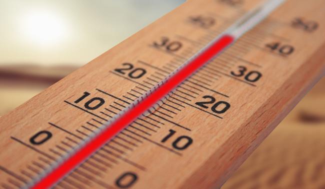
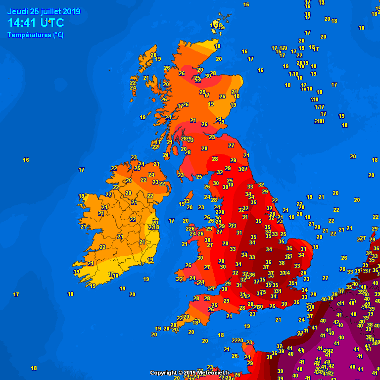
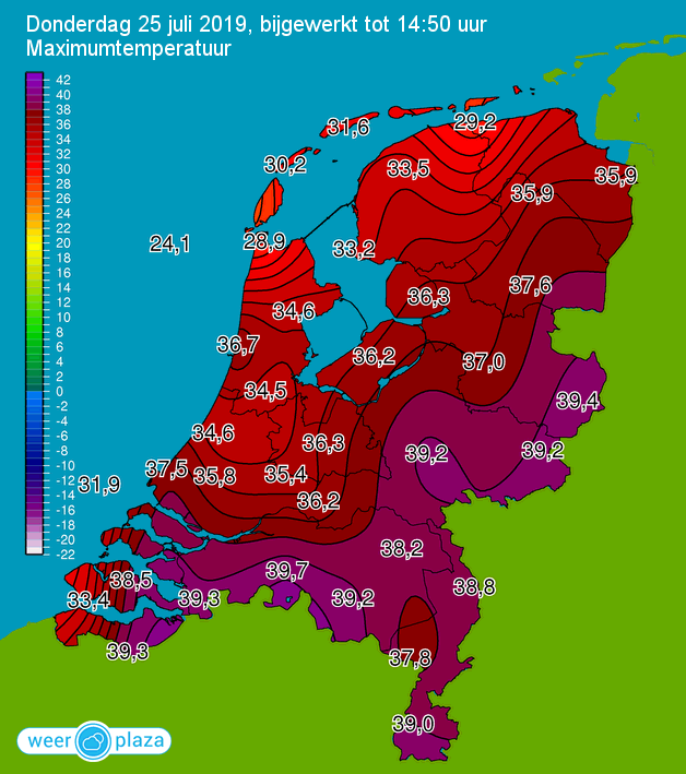
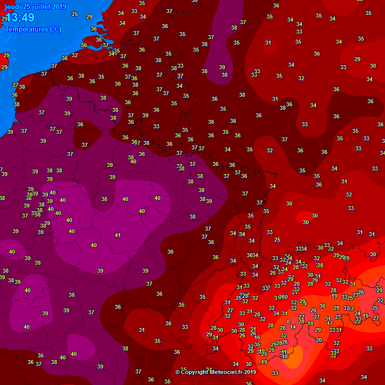
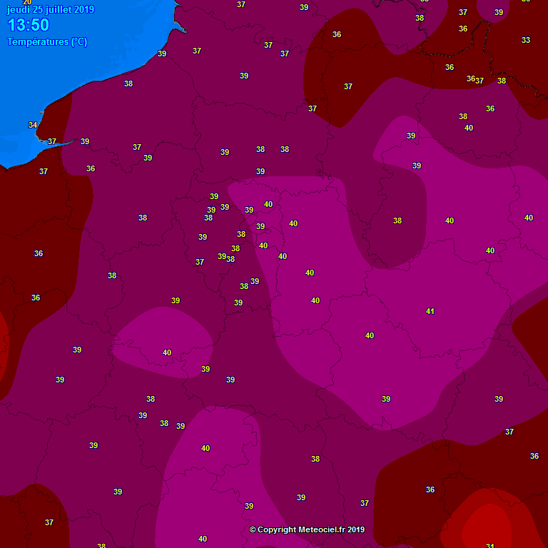
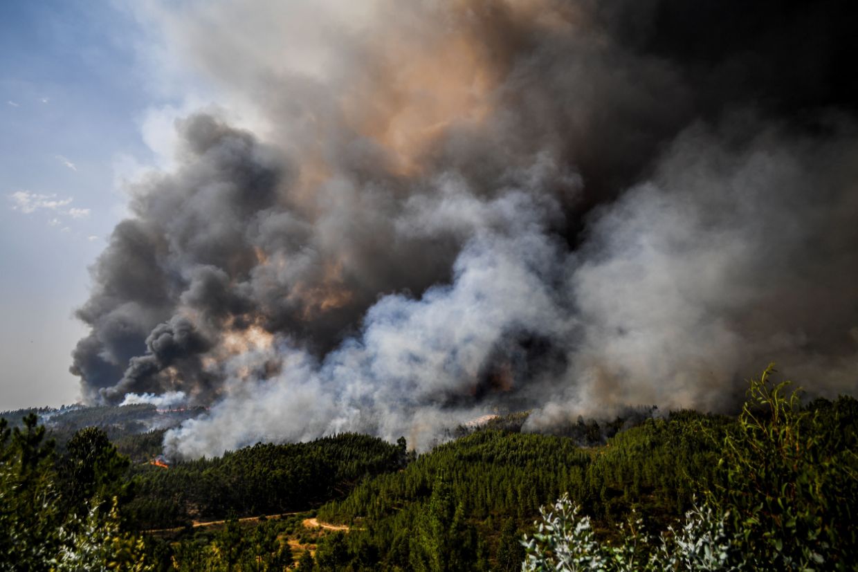
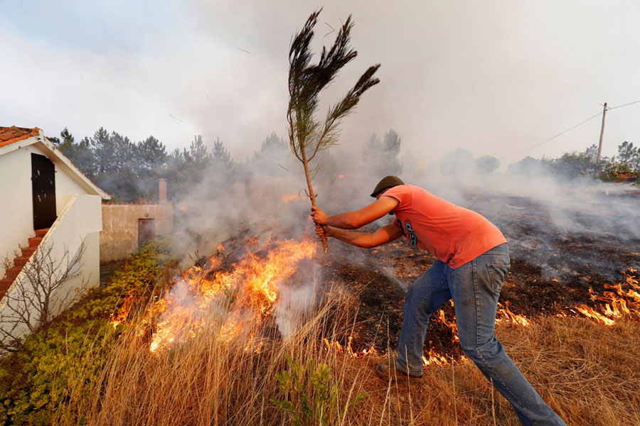
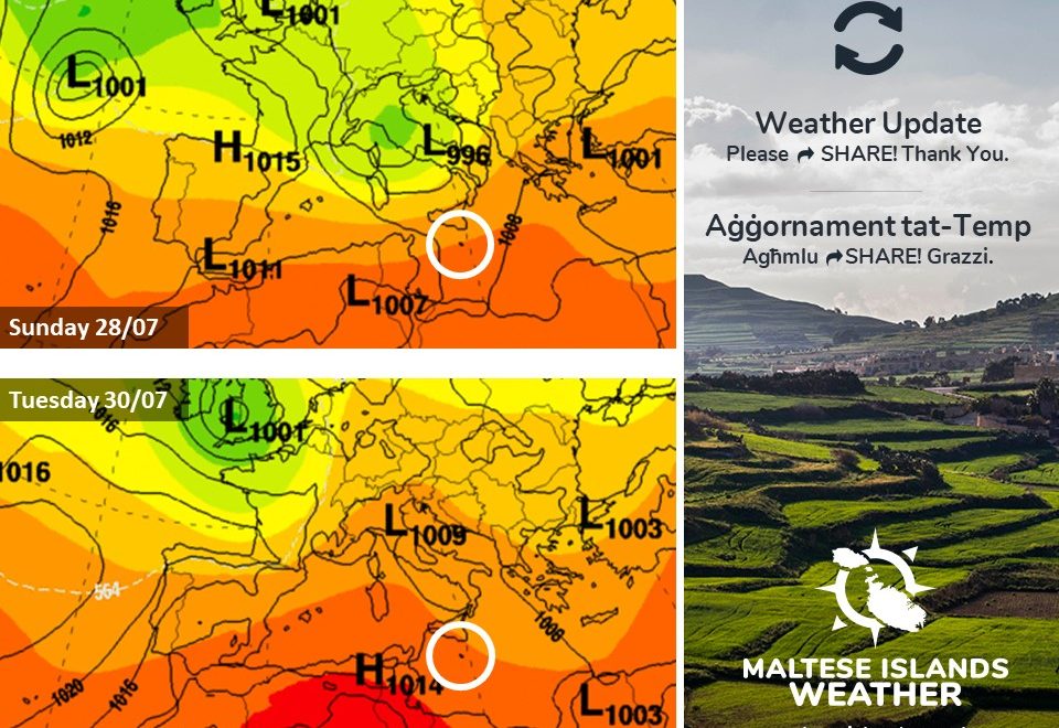
Recent days have seen maximum temperature records being broken across western Europe, as heat from the south engulfed the area. Now, cold Arctic air has penetrated the region. The clash being the two air masses has triggered the development of a low pressure system. Bad weather will be affecting large parts of Europe over the coming days, as a result. The edge of this low pressure system will be moving across the central Mediterranean, affecting us in the process. The impact on the Maltese Islands will be to a far lesser extent than that on the rest of Europe.

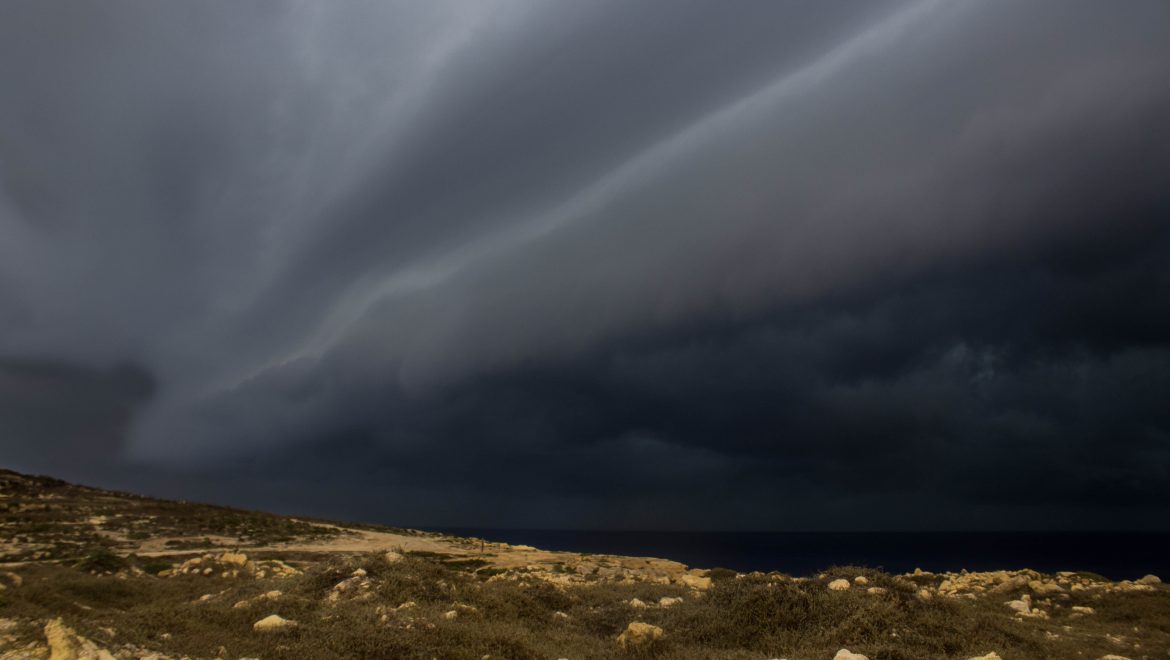
A trough of low pressure system traversing the central Mediterranean late on Saturday 27/07 will mean a brief cloudy sky for the Maltese Islands overnight. The sky should become mainly sunny or partly cloudy by morning on Sunday 28/07. The wind from the South will reach Force 4/5 at times on Saturday night. It will turn Northwest by noon on Sunday, and increase slowly to become Force 5/6 by the evening, because of the contrast between high pressure over the western Mediterranean and lower pressure locally. It will remain strong till early on Tuesday 30/07, when high pressure restores fine weather to the Maltese Islands.

L-aħħar jiem raw rekords tat-temperaturi jinkisru madwar il-punent ta’ l-Ewropa, minħabba sħana kbira minn fuq l-Afrika ta’ fuq. Issa, kesħa minn fuq l-Artiku qed taħkem dawn l-istess inħawi. Id-differenza bejn dawn iż-żewġ masses ta’ arja b’temperaturi differenti wasslu biex żviluppat sistema ta’ pressjoni baxxa. Maltemp għandu jaħkem il-biċċa l-kbira ta’ l-Ewropa fil-jiem li ġejjin. It-tarf ta’ din is-sistema ta’ pressjoni baxxa se jkun qed jgħaddi minn fuq iċ-ċentru tal-Mediterran, u għalhekk se jaffetwa lilna wkoll. L-effett ta’ din fuq il-Gżejjer Maltin se jkun anqas minn dak fuq il-bqija ta’ l-Ewropa.

Front dgħajjef se jgħaddi minn fuq iċ-ċentru tal-Mediterran tard is-Sibt 27/07. Dan se jkun qed iġib miegħu sema msaħħab għal xi ħin matul il-lejl. Is-sema jerġa jsir il-biċċa l-kbira xemxi jew ftit imsaħħab sa filgħodu l-Ħadd 28/07. Ir-riħ minn Nofsinhar se jilħaq Forza4/5 kultant matul il-lejl tas-Sibt. Dan se jdur mill-Majjistral ma’ nofsinhar tal-Ħadd, u jżid bilmod sa ma jsir Forza 5/6 minn filgħaxija. Dan minħabba kuntrast bejn roqgħa ta’ pressjoni għolja fuq il-punent tal-Mediterran u pressjoni aktar baxxa fuqna. Ir-riħ se jibqa qawwi sa kmieni t-Tlieta 30/07, meta arja bi pressjoni għolja terġa ġġib temp bnazzi lejn il-Gżejjer Maltin.

Updates

August 2019 to be the hottest month of 2019 but … / Awwissu 2019 se jkun l-aktar xahar sħun ta’ l-2019 imma …

With an average high of 31.5 C and an average low of 24.4 C, July 2019 has so far been more than 1.5 C warmer than normal. That’s exactly as forecast at the start of the month. The maximum temperature this month was reached on the 9th, when it had soared to a sweltering 38.3 C. That was just more than 7 C hotter than the mean for that time of year. With a low of 26 C, the following night was the warmest this month. Having reached the last days of July, we can safely say that like June 2019, July 2019 is following the same pattern as in July 2012 and July 2017, two years with very hot summers. We’ll know exactly how hot it was when our end of month report is published on Thursday. Just as in 2012 and 2017, August 2019 will also be hotter than average. The grip that anticyclones have had on the central Mediterranean so far this summer will continue into August. These will continue drawing hot to very h0t air from over north Africa towards our region. This will mean consistent above-average temperatures with heat spells being very likely. The average temperature in August generally stands at 27.1 C, and is normally the hottest month of the year. This year it will be no different. The latest map projections suggest that August 2019 will be around 1.5 C warmer than usual, making it the hottest month of 2019. That doesn’t mean the weather will be all sunny, calm and hot throughout. The same map projections still indicate the possibility of an early autumn, with some showers and thunderstorms possibly affecting us towards the end of the month.

Bl-ogħla temperatura fil-medja ta’ 31.5 C u l-anqas fil-medja ta’ 24.4 C, Lulju 2019 sa issa kien aktar min 1.5 C aktar sħun minn normal. Dan kien eżatt kif imbassar. L-ogħla temperatura ġiet imkejjla nhar id-9 ta’ Lulju, meta laħqet 38.3 C. Din kienet aktar minn 7 C ogħla mill-medja għal dan iż-żmien tas-sena. Bl-anqas ta’ 26 C, il-lejl ta’ wara kien l-aktar sħun dan ix-xahar. Issa li wasalna fl-aħħar jiem ta’ Lulju, nistgħu ngħidu li bħal Ġunju 2019, Lulju 2019 qed isegwi l-istess passi ta’ Lulju 2012 u Lulju 2017, sentejn li kellhom sjuf sħan ferm. Inkunu nafu eżatt kif kien dan ix-xahar meta noħorġu r-rapport ta’ l-aħħar tax-xahar nhar il-Ħamis. Bħal fl-2012 u l-2017, Awwissu 2019 ukoll se jkun aktar sħun mill-medja. Il-morsa li l-antiċikluni kellhom fuq iċ-ċentru tal-Mediterran dan is-sajf se tkompli matul ix-xahar ta’ Awwissu. Dawn se jkompli jiġbdu arja sħuna għal sħuna ħafna minn fuq it-tramuntana ta’ l-Afrika lejn ir-reġjun tagħna. Dan se jfisser temperaturi ogħla mill-medja b’mod konsistenti u b’mewġiet ta sħana jkunu probabli. It-temperatura medja matul ix-xahar ta’ Awwissu hija dik ta’ 27 C, u normalment ikun l-aktar xahar sħun tas-sena. Din is-sena mhux se jkun differenti. L-aktar mapep riċenti qed jindikaw li Awwissu 2019 għandu jkun 1.5 C aktar sħun minn normal, u għalhekk mistenni jkun l-aktar xahar sħun ta’ l-2019. Dan ma jfissirx li t-temp se jkun xemxi, kalm u sħun kuljum. L-istess mapep għandhom juru l-possibilita ta’ ħarifa bikrija, b’xi ħalbiet tax-xita u maltempati bir-ragħad ikunu possibbli lejn tmiem Awwissu.

Updates

Second record-breaking heatwave in Europe / It-tieni mewġa ta’ sħana rekord fl-Ewropa

Much of Western Europe is facing record-breaking temperatures once again, with the second heatwave in a month reaching its peaking on Thursday 25/07. Heatwave conditions have already caused forest fires, grounded planes and buckled train tracks and led to closures of places of work and warnings over air quality. In France, officials warned people to avoid travelling and to work from home if possible. The chief architect responsible for restoring the Notre-Dame warned that the extreme heat could lead to the cathedral roof collapsing if the joints and masonry holding up the roof dry out. In parts of north Germany, rivers and lakes have dried up. In the Netherlands, hundreds of pigs died after a ventilator at a farm failed. Meanwhile, a Eurostar train from Brussels to London broke down, trapping passengers. This heatwave is the result of a zone of high pressure over Denmark and Scandinavia. This dragged hot air from over north Africa, Portugal and Spain towards northwestern Europe. This raised temperatures and relative humidity, creating deadly heatwave conditions. An intense heatwave in June had through areas of Europe, making it the hottest June on record. France set an all-time temperature record of 46 C. New June highs were set in the Czech Republic, Slovakia, Austria, Andorra, Luxembourg, Poland and Germany. This time round, records have been broken once again. Germany set a new temperature record, reaching 41.5 C in the west. With a temperature of 42.6 C, Paris experienced its hottest day ever today. With a maximum of 38.1 C in Cambridge, the temperature in the UK was just 0.4 C short of breaking the all time record. The Netherlands also recorded its hottest ever temperature, with the high in Deelen reportedly soaring to 42.9 C. The Belgian town of Kleine Brogel hit 39.9 C, the hottest since 1833.

Il-biċċa l-kbira tal-punent ta’ l-Ewropa mill-ġdid qed tesperjenza mewġa ta’ sħana rekord, bit-tieni mewġa ta’ sħana f’xahar tilħaq l-aqwa tagħha l-Ħamis 25/07. Din il-mewġa ta’ sħana kkaġunat nirien, waqqfet ajruplani u għamlet ħsarat fis-sistema tal-ferroviji, kif ukoll wasslet biex ingħalqu postijiet tax-xogħol u nħarġu twissijiet ta’ kwalita’ ta’ arja baxxa. Fi Franza, l-awtoritajiet avżaw lill-pubbliku biex kemm jista jkun ma joħorġux minn djarhom. L-arkitett li qed imexxi r-restawr tan-Notre-Dame wissa li s-sħana tista twassal biex ikompli jaqa dan il-katidral, jekk l-injam ikompli jinxef aktar. F’xi partijiet tal-Ġermanja, għexieren ta’ xmajjar u għadajjar nixfu kompletament. Fl-Olanda, mijiet ta’ ħnieżer mietu meta ventilatur fir-razzett li kienu qed jinżammu fih waqaf jaħdem. Sadattant, ferrovija tal-Eurostar minn Brussel sa Londra waqfet, bil-passiġġieri jispiċċaw maqbuda fuqha għal siegħat twal. Din il-mewġa ta’ sħana hija r-riżultat ta’ roqgħa ta’ pressjoni għolja fuq id-Danimarka u l-Iskandinavja. Din ġibdet arja sħuna ħafna minn l-Afrika ta’ fuq, il-Portugall u Spanja lejn il-majjistral ta’ l-Ewropa. Riżultat ta’ dan, it-temperatura telgħet u l-umdita għoliet. Dan wassal għal kundizzjonijiet perikolużi immens. Mewġa ta’ sħana intensa kienet ħakmet lill-istess inħawi f’Ġunju. Dakinhar, Franza rat temperatura rekord ta’ 46 C. Din id-darba, ġew miskura rekords oħrajn. Fil-Ġermanja, tkejjlet temperatura rekord ta’ 41.5 C fil-punent tal-pajjiż. B’temperatura ta’ 42.6 C, Pariġi esperjenza dik li kienet l-aktar ġurnata sħuna li qatt kienet imkejjla. Bl-ogħla ta’ 38.1 C f’Cambridge, it-temperatura fir-Renju Unit kienet 0.4 C anqas minn l-ogħla li qatt tkejjlet fil-pajjiż. L-Olanda wkoll kienet maħkuma temperaturi rekord, bl-ogħla f’Deelen tilħaq 42.9 C. Il-belt ta’ Kleine Brogel fil-Belġju messet 39.9 C, l-ogħla minn 1833.


Updates

Will August 2018 repeat itself? / Awwissu 2018 se jirrepeti ruħu?

August 2018 was the wettest in recent years. 40.4 mm were measured at our weather station in Għarb. This was spread over four days (the 6th, 20th, 21st and 22nd). Thunderstorms occurred on two of these four days. Daytime highs were cooler while nighttime highs were warmer. The cooler than average maximum temperatures could be explained by the cooling effect normally brought about by the first rain. What are the expectations for August 2019? When will the first rain drench the Maltese Islands? Latest long-term maps do indicate an early autumn, but it will not be as early as last year. The rain is unlikely to start before Santa Marija, although an episode of isolated showers is possible before then. These are still early days, but preliminary long-term maps are indicating that the first ‘real’ rain will drench the Maltese Islands just after Santa Marija. This will be confirmed by future maps.

Awwissu 2018 kien l-aktar imxarrab fl-aħħar snin. 40.1 mm ta’ xita kienu ġew imkejjla fl-istazzjon metejoroloġiku tagħna fl-Għarb. Din kienet mifruxa fuq erbat ijiem (6th, 20th, 21st u 22nd). Maltempati bir-ragħad kienu ħakmuna f’jumejn minn dawn l-erbat ijiem. L-ogħla temperatura kienet aktar friska mill-medja, filwaqt li l-anqas billejl kienet aktar sħuna minn normal. L-ogħla temperatura kienet anqas minn normal minħabba l-arja friska li ġġib magħha l-ewwel xita. X’qed nistennew għal Awwissu 2019? Meta se jkollna l-ewwel xita fil-Gżejjer Maltin? L-aħħar mapep fit-tul jindikaw ħarifa bikrija. Minkejja dan, il-ħarifa mhux se tibda kmieni daqs is-sena l-oħra. Ix-xita ma jidhirx li se tibda qabel Santa Marija, għalkemm xi episodju ta’ ħalbiet iżolati tax-xita huwa possibbli qabel dakinhar. Għadu kmieni, imma l-ewwel mapep qed juru li l-ewwel xita ‘vera’ għandha tmissna eżatt wara Santa Marija. Din se tkun konfermata minn mapep futuri.

Updates

This week: Summer weather to return

Last week saw some rain and strong winds in its first half, with cooler than average temperatures throughout. This week will see the return of summer ed-italia.com. An anticyclone over the central Mediterranean will strengthen. This will draw hot air from north Africa towards much of Europe, including our region. Temperatures will be warmer than average, with highs in the range of 32 C to 34 C. Nighttime lows will be at 24 C on all nights. The anticyclonic conditions will mean mainly sunny or partly cloudy skies with light and variable winds throughout the week.

Looking at the meteorological situation for next week, the average daytime temperature will be around 33 C, with a high for the week of 34 C expected from Monday 22/07 till Wednesday 24/07 and on Sunday 28/07. Nighttime lows will be of 24 C on all nights. No rain is expected this week. Winds are set to be light and variable throughout. It will be at its strongest in the afternoons, when it could reach Force 3/4 at times.

Updates

Indefinite heat spell ahead / Mewġa ta’ sħana indefinita

An anticyclone over the central Mediterranean will strengthen over the coming days. This will draw very hot air from over north Africa, bringing yet another heat spell to the Maltese Islands. This time round, however, it is expected to last indefinitely. From Monday 22/07 onward, maximum temperatures will soar to 33 C or higher. That is more than 2 C more than average. Minimum temperatures will be in the region of 24 C on most nights. That means no relief at night. Winds will be mainly light and variable. Skies will be sunny or mainly sunny. This heat spell will not qualify as a heatwave though, as maximum temperatures should never be more than 5 C hotter than normal for three or more consecutive days. It will last indefinitely, though, meaning there is no end to it in sight in the near future. In fact, this heat spell could stretch into August.

Antiċiklun fuq iċ-ċentru tal-Mediterran se jissaħħaħ fil-jiem li ġejjin. Dan se jġib miegħu arja sħuna ħafna minn fuq l-Afrika ta’ fuq, u b’hekk se l-Gżejjer Maltin se jesperjenzaw mewġa ta’ sħana oħra. Din id-darba din se tkopri żmien indefinit. Minn nhar it-Tnejn 22/07 ‘il quddiem, it-temperaturi massimi se jitilgħu għal 33 C jew ogħla. Dan se jkun aktar minn 2 C ogħla mill-medja. It-temperaturi minimi se jkunu fir-reġjun ta’ 24 C fil-maġġoranza ta’ l-iljieli. Mhux se jkun hemm soljev mis-sħana billejl. Ir-riħ se jkun il-biċċa l-kbira ħafif u Varjabbli. Is-sema jkun xemxi jew il-biċċa l-kbira xemxi. Minkejja dan, din is-sħana mhux se tikkwalifika bħala heatwave, minħabba li t-temperaturi massimi mhux se jaqbżu l-medja b’aktar minn 5 C għal tlett ijiem jew aktar. Din se ddum għal żmien indefinit, pero, bl-ebda tmiem fil-futur qrib. Filfatt, taf tibqa tiġġedded anke sa Awwissu.

Updates

Summer to return / Is-sajf se jirritorna

The past two days brought a very brief break from summer weather to the Maltese Islands. With cooler than average temperatures, strong winds and also some rain; it was welcome by some. Summer weather will make a swift return, however, as an expanding area of high pressure over the western Mediterranean will be extending eastwards to cover the central Mediterranean. Summer will return to the Maltese Islands on Wednesday 17/07. The weather will be sunny or mainly sunny again. The wind will die down by morning. It will become light and Variable again from then on. A rise in air temperature will also be noted. Highs will once again rise to above 30 C. This gradual improvement in the meteorological situation will catch momentum into next week, when daytime temperatures will rise to 33 C or above again. Nighttime lows will once again rise to 23 C or above. We assure feast organisers that it will be safe to decorate the streets with delicate decorations again from Wednesday 17/07. Also, outdoor celebrations may be held as initially planned from later on Tuesday 16/07.

L-aħħar jumejn ġabu soljev qasir ħafna minn temp tipiku sajfi. B’temperatura ta’ anqas mill-medja, riħ qawwi, u xi ftit xita; din il-waqfa kienet mistennija minn uħud. Temp sajfi se jirritorna minnufih pero, hekk kif roqgħa ta’ arja bi pressjoni għolja fuq il-punent tal-Mediterran qed tespandi u se tersaq lejna biex tgħatti ċ-ċentru tal-Mediterran. Din se tibda taffetwana minn l-Erbgħa 17/07. It-temp se jerġa jibda jkun xemxi jew il-biċċa l-kbira xemxi. Ir-riħ mistenni jieqaf kważi għal kollox sa filgħodu. Se jerġa jibda jkun ħafif u Varjabbli. It-temperaturi se jiżdiedu wkoll. L-ogħla se terġa tilħaq it-30 C. Dan it-titjib fit-temp se jaqbad ir-ritmu sew matul il-ġimgħa li ġejja, meta t-temperaturi se jilħqu 33 C jew aktar. L-anqas billejl se terġa tibda tkun aktar minn 23 C. Nistgħu nserrħu moħħ l-organiżżaturi tal-festi li minn l-Erbgħa 17/07 jistgħu joħorġu t-tiżjin delikat. Minbarra, ċelebrazzjonijiet ta’ barra jistgħu jseħħu eżatt kif pjanat minn aktar tard it-Tlieta 16/07.

Updates

Rainfall in July is rare but … / Xita f’Lulju hija rari imma …

Rainfall in July is rare but not unheard of. Isolated showers which were briefly heavy at times have affected parts of the Maltese Islands on Monday 15/07 and Tuesday 16/07. Just over 2.5 mm were measured in parts of Gozo, the wettest area this time round. That may seem negligible to many, but it is already far more than the July mean of 0.4 mm. 1.3 mm were measured at our weather station in Għarb. The temperature dipped to 22 C during the rain. That is almost 10 C lower than the average for this time of year, and on par with the average minimum temperature for this time of year. The last time rainfall was recorded in July was back in 2011. 2.1 mm were measured back then. It was in the form of an isolated shower similar to today’s. We’ve also had some severe weather events in July in the past. A case in point was on 18th July 2006, when an isolated thunderstorm affected the extreme northeast of Malta. There was heavy rainfall for about 2 hours. with accumulations of up to 50 mm in Marsascala. A waterspout was also seen over St.Thomas Bay during the thunderstorm.

Xita f’Lulju hija rari imma ġieli ġrat. Ħalbiet iżolati tax-xita li kienu qawwijin għal ftit ħin kultant affetwaw xi nħawi tal-Gżejjer Maltin it-Tnejn 15/07 u t-Tlieta 16/07. Ftit aktar minn 2.5 mm tkejjlu f’xi partijiet ta’ Għawdex, l-aktar parti milquta din id-darba. Dan l-ammont ta’ xita ma jfisser xejn għal ħafna, imma dan huwa diġa ferm aktar mill-medja għax xahar ta’ Lulju ta’ 0.4 mm. 1.3 mm kienu mkejjla fl-istazzjon tat-temp tagħna fl-Għarb. It-temperatura naqset drastikament. Din naqset għal 22 C, kważi 10 C anqas mill-medja għal dan iż-żmien tas-sena, u eżatt daqs il-medja tat-temperatura minima għax-xahar ta’ Lulju. L-aħħar darba li għamlet xita f’Lulju kien fl-2011. 2.1 mm kienu mkejjla dakinhar. Ix-xita kienet f’forma ta’ ħalba iżolata bħal tal lum. Kellna wkoll xi maltemp sever f’Lulju fil-passat. Eżempju ta’ dan kien fit-18 ta’ Lulju 2006, meta maltempata bir-ragħad iżolata ħakmet il-grigal estrem ta’ Malta. Dakinhar kellna xita qawwija għal xi sagħtejn, b’total ta’ madwar 50 mm f’Marsaskala. Tromba ta’ l-arja fuq il-baħar kienet osservata fyq il-Bajja ta’ San Tumas waqt il-maltempata.

Updates

Partial Lunar Eclipse tonight / Eklissi Parzjali tal-Qamar illejla

Are you ready for tonight’s partial lunar eclipse across the Maltese Islands? Weather conditions will be optimum as visibility will be excellent with little or no clouds. There will be no desert dust or fog in sight. The wind will decrease rapidly in the evening, and become Force 3/4 by the time of the partial lunar eclipse. The Moon will be low over the horizon. Look towards the southeast horizon to view the eclipse from 22:01 CEST onward tonight Tuesday 16th July 2019.

Below is the exact timetable. Unlike weather, the schedule will be followed to the minute detail and more accurate than buses or trains.

20:10 CEST -> Moon rises over Valletta, Malta
22:01 CEST -> Partial eclipse begins
23:30 CEST -> Maximum eclipse
00:59 CEST -> Partial eclipse ends
06:14 CEST -> Moon sets over Valletta, Malta

The partially eclipsed moon should appear bright red tonight very similar to this photo tonight.


Lesti għal eklissi parzjali tal-qamar li se jidhru mill-Gżejjer Maltin illejla? It-temp se jkun perfett hekk kif il-visibilita se tkun eċċellenti bi ftit li xejn sħab. Mhux se jkun hemm trab fin jew ċpar madwarna. Ir-riħ mistenni jonqos malajr filgħaxija, u jsir Forza 3/4 sa x’ħin ikun se jibda l-eklissi. Il-Qamar se jkun baxx fis-sema. Ħarsu lejn ix-Xlokk sabiex taraw l-eklissi li se tibda fl-22:01 CEST illejla t-Tlieta 16 ta’ Lulju 2019.

Hawn taħt tistgħu taraw il-ħinijiet eżatti. Bl-oppost tat-temp, dawn il-ħinijiet huma preċiżi.

20:10 CEST -> Il-Qamar jitla fuq il-Belt Valletta, Malta
22:01 CEST -> L-eklissi parzjali tibda
23:30 CEST -> Il-massimu ta’ l-eklissi
00:59 CEST -> L-eklissi parzjali tintemm
06:14 CEST -> Il-Qamar jinżel fuq il-Belt Valletta, Malta

Il-Qamar għandu jidher aħmar illejla, simili għal dan ir-ritratt.

Updates

Rain in the midst of July? / Xita f’nofs Lulju?

July is well known for being the driest month of the year. Despite this, it’s mid-July, and parts of the Maltese Islands have experienced a heavy rain shower. Also, there is more to come! A low pressure system passing over southern Italy has already started affecting us. Apart from some rain, this will bring with it cooler than average temperatures, strong winds and cloudier skies till Wednesday 17/07. The chance of rain will be at its highest on Monday 15/07 and Tuesday 16/07, when isolated showers, possibly briefly heavy at times, could affect some parts of the Maltese Islands. Total rainfall will not exceed 5 mm. This will happen as the wind veers from the Southeast to Northwest. Hot air brought over by the Southeast wind will meet cooler air brought over by the Northwest wind right over the Sicilian Channel, causing patches of isolated showers and thunderstorms to develop. No severe weather is to be expected.

Lulju huwa magħruf bħalha l-aktar xahar niexef tas-sena. Minkejja dan, wasalna f’nofsu u xi nħawi tal-Gżejjer Maltin esperjenzaw ħalba xita qawwija. Apparti din, hemm aktar x’jgħaddi minn ħdejna. Sistema ta’ pressjoni baxxa li għaddejjha minn fuq in-nofsinhar ta’ l-Italja diġa bdiet taffetwana. Apparti minn xi ftit xita, din se ġġib magħha temperaturi anqas mill-medja, riħ qawwi u sema aktar imsaħħab sa l-Erbgħa 17/07. Iċ-ċans ta’ xita se jkun l-ogħla nhar it-Tnejn 15/07 u t-Tlieta 16/07, hekk kif ħalbiet iżolati tax-xita, li jistgħu jkunu qawwijin għal xi ħin kultant, jistgħu jaffetwaw partijiet mill-Gżejjer Maltin. It-total ta’ xita mhux se jaqbeż il-5 mm. Din se sseħħ hekk kif ir-riħ jaqleb minn Xlokk għal-Majjistral. L-arja sħuna li jġib miegħu riħ mix-Xlokk se tiltaqa ma’ arja friska li jġib miegħu riħ mill-Majjistral. Dan se jseħħ fuq il-Kanal ta’ Sqallija, u se jwassal biex jiffurmaw diversi ħalbiet iżolati tax-xita u maltempati bir-ragħad iżolati f’dan ir-reġjun. Mhux qed nistennew maltemp sever.