
Never the same twice, clouds are the most dynamic features of our natural world. They can vary from benign, fluffy white masses drifting in the summer sky to towering storm clouds that drench the Earth’s surface with rain and hail and illuminate the sky with vivid flashes of lightning. Not matter what shape they take, every cloud is a visible mass of tiny water droplets or ice crystals. They are essential in the production of life-giving rainfall. With only some very rare exceptions, clouds exist entirely within the troposphere, the lowest layer of the atmosphere.
Clouds are formed when moist air is cooled sufficiently for its water vapour content to reach saturation, followed by either condensation to form water droplets, or by deposition to form ice crystals. Usually, the cooling occurs when relatively warm air from near the ground is carried up and expands into colder, lower-pressure levels higher in the atmosphere. The formation of droplets or crystals requires the presence of tiny airborne nuclei in the atmosphere. These serve as sites for condensation or deposition to occur. In the case of blood rain, water vapour condenses onto fine desert sand in atmosphere. The fine desert sand falls with the rain.
When conditions are above freezing, water droplets will form. Over time, the droplets grow in size as more vapour molecules are drawn toward them and are captured. This process continues until the droplets are about 0.02 mm in diameter, then the growth rate slows and the cloud is made up of a stable population of droplets.
Precipitation occurs when some of the droplets or ice crystals that constitute a cloud grow large enough to fall to Earth under the influence of gravity. Two processes can cause this to happen, and they can occur both individually and in combination.
The first process, known as coalescence, is likely to occur in very moist cumuliform clouds and when temperatures are above freezing. The water droplets in clouds are generally so small that they are kept aloft by air resistance and rising air currents, despite the effects of gravity. However, if turbulence within the cloud causes these droplets to collide, they may merge with one another to form larger droplets, and eventually these droplets will become heavy enough to fall from the cloud. As they fall, they collide with more droplets, continuing to grow in size until reaching the ground as rain.
The second process, known as the Bergeron process, requires ice crystals to be present in the cloud. It is most likely to occur in thick clouds at middle or high latitudes, where super-cooled water droplets and ice crystals coexist. Ice crystals and super-cooled water droplets have different saturation points, so when they coexist in a cloud, water molecules will move from the water droplets to the ice crystals. Under these conditions, the ice crystals will grow quickly at the expense of the water droplets until they are large enough to fall. When falling, they will tend to grow further through the process of accretion (growth by the gradual accumulation of ice crystals), and may reach the ground as ice pellets or may melt on the way down to fall as rain.
CLOUD FORMATION
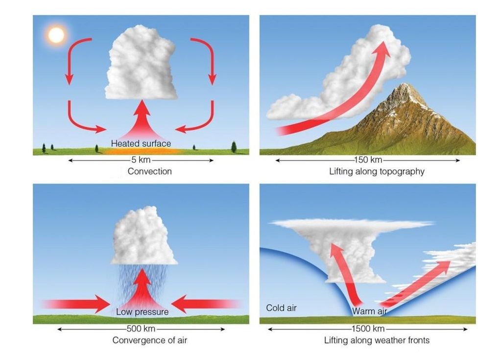
Almost all clouds form by the rising of warm, moist air upward into cooler, less dense levels of the atmosphere, where the water vapour condenses. There are various mechanisms that drive this movement and each gives rise to a distinctive set of cloud types. The strength of the uplift can result in anything from benign cumulus or cirrus clouds to violent cumulonimbus storm clouds. Orographic lifting occurs when an air mass encounters a mountain range. The mountain range forces the air upward, often lifting it to condensation level. Convectional lifting occurs when an air mass, heated by contact with warm ground or surface, becomes buoyant and rises. This lifts it to the condensation level. Frontal lifting occurs when two air masses of different temperatures meet along a front. The warmer air is forced to rise. This lifts it to the condensation level. Convergence occurs when two air masses collide. Some air is forced upwards. This lifts it to the condensation level.
CLOUD CLASSIFICATION
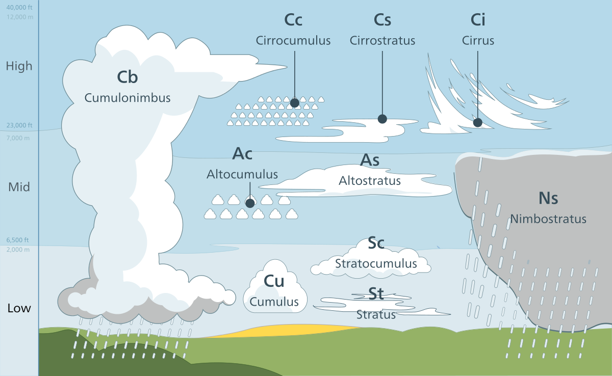
Many different types of clouds are observed in nature and each type of identified by its special name. In 1803, Luke Howard first used Latin words to describe four main types: cirrus (wisp), cumulus (heap), stratus (layer) and nimbus (rain-bearing). With the addition of the word ‘alto’ for mid-level clouds, a combination of these prefixes is used to refer to all main clouds. The main clouds are:
- Cumulus – A small cumulus cloud with little vertical development, usually seen in fair weather.
- Nimbostratus – Dark gray, generally featureless cloud layers that precipitate rain or snow.
- Stratocumulus – A horizontally spreading cumulus cloud.
- Stratus – A layer cloud, thin with considerable horizontal development, Usually featureless.
- Altostratus – A layer cloud that frequently covers the whole sky.
- Altocumulus – An accumulation of small cumulus clouds forming a layer.
- Cirrus – Ice crystal clouds with ‘mare’s tails’ caused by horizontal winds varying with height.
- Cirrostratus – Cirrus clouds that cover a wide area of the sky in an often barely-visible layer.
- Cirrocumulus – Puffy clouds that coalesce in sheets or regularly spaced lines.
- Cumulonimbus – A thunder cloud capable of moderate to heavy precipitation.
In upcoming posts we’ll be dealing with the different cloud types separately.
0 comments
Write a comment