
What is a typical May like according to climate statistics?
|
Mean Maximum Temperature |
Mean Minimum Temperature | Mean Temperature | Total Rainfall |
| 23.9°C | 15.9°C | 19.8°C |
9.4 mm |
What do long-term weather maps indicate for May 2023?
May is the third and final month of meteorological spring. May is normally characterized by the continued transition to summer. The weather is typically brighter and warmer. Climatically, temperatures rise substantially over the course of the month. One would expect most days to be comfortable, although some evenings could still feel relatively fresh. Whilst spells of fine weather typically become longer and more frequent, they continue to be interrupted by the odd spell of grey skies, breezy winds and isolated light rain. The chance of rain normally dips in May. Precipitation in May is often unpredictable, however. In the majority of years, May marks the start of the summer drought. On the other hand, thunderstorms are not unheard of in May. This would occur due to the upper levels of the atmosphere still being relatively unstable. Sirocco winds are also quite common, and therefore, the threat of dusty rain and airborne fine desert sand from the Sahara extends into the first half of May. Long-term models are indicating that, with regards to precipitation, May 2023 will likely end up being around average. The first half of the month is likely to be relatively unstable. The first half of the month is likely to be around or slightly cooler than average too. The meteorological situation should stabilize more as the month enters its second half. The chance of rain should drop and temperatures rise, with the first heat spell of the season possibly taking place towards the end of May.
What do long-term weather maps indicate for the longer-term?
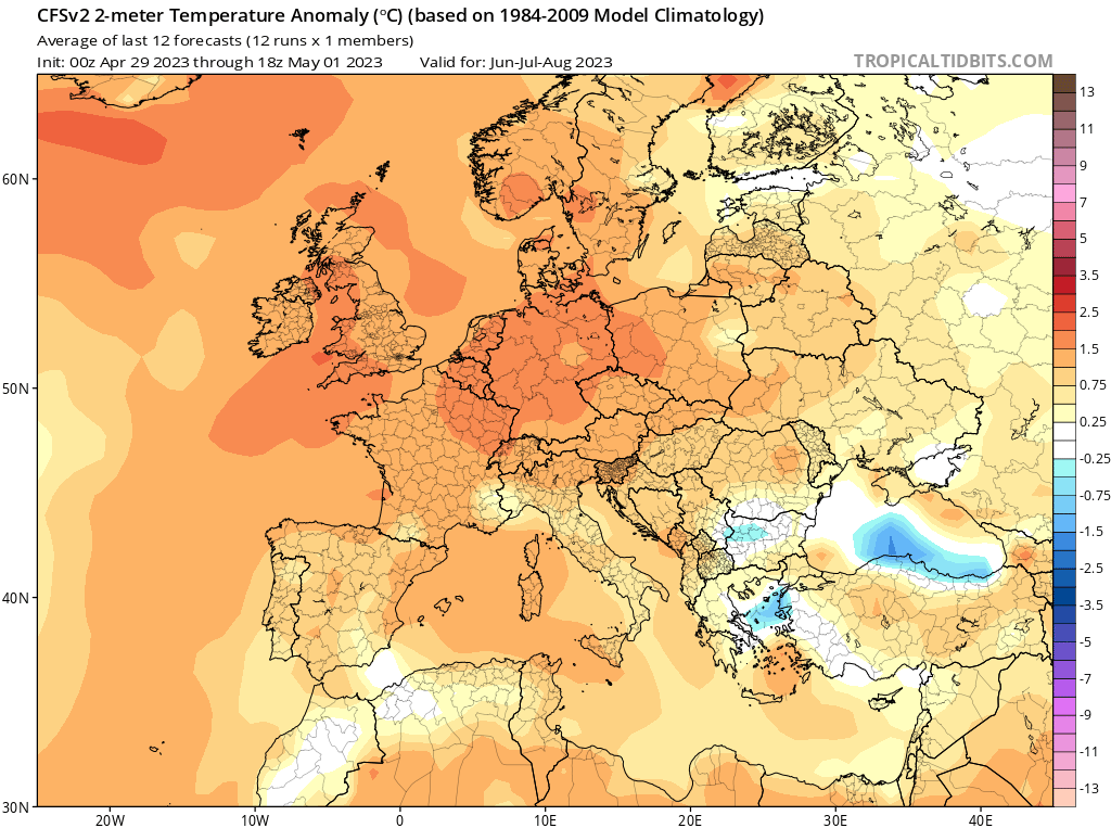
FURTHER OUTLOOK (TEMPERATURE) FOR JUNE 2023 – JULY 2023 – AUGUST 2023 Average
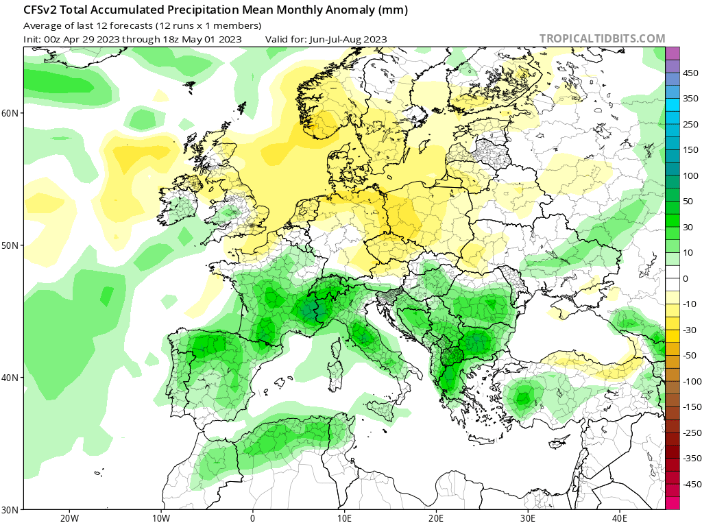
FURTHER OUTLOOK (PRECIPITATION) FOR JUNE 2023 – JULY 2023 – AUGUST 2023 Average*
* An ‘Average’ outlook means that maps are pointing towards normal storm system activity around the central Mediterranean. How seasons fare in terms of actual precipitation amounts measured locally depends on whether the rain-producing systems that form around the Maltese Islands affect land or not.
-
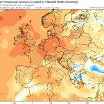
- Long-term seasonal model for temperature for June 2023/July 2023/August 2023
-
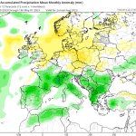
- Long-term seasonal model for temperature for June 2023/July 2023/August 2023
Disclaimer: Specific details on the weather may only be given for a couple of days in advance. This long-term forecast is not meant to determine specific weather parameters at a point on the Maltese Islands. Instead, it looks at large scale weather patterns across Europe, and attempts to determine how these may influence the weather locally. Our levels of confidence in the forecast for the month ahead are fair. These are reasonably lower when it comes to the ‘Further Outlook’ section. Weather forecasts are an interpretation of possible weather events based on trends, maps and climate data at the time of the forecast, and as a result, weather predictions may always change over time. Maltese Islands Weather can never be held responsible for any direct, indirect, incidental, consequential, special or exemplary damages or even lost profit resulting from any use or misuse of this data. The user assumes the entire risk related to the use or misuse of this data.