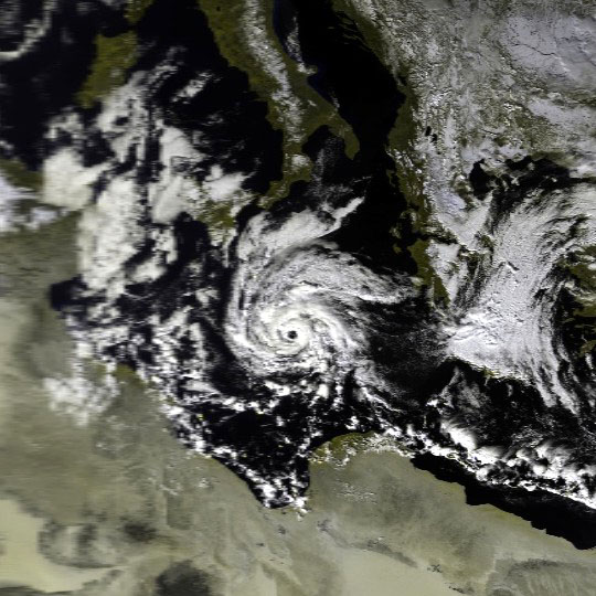
We’ve mentioned the terms ‘Mediterranean Tropical-Like Cyclone’ and ‘Medicane’ multiple times in the past few hours or so. What is it? Mediterranean cyclones are a very rare meteorological phenomenon. The majority form over two regions: the first encompasses an area of the western Mediterranean bordered by the Balearic Islands, southern France, and the shorelines of Corsica and Sardinia; the second is in the Ionian Sea encompassing the region between Sicily and Greece and as far south as Libya. The Maltese Islands are situated within the latter. The mountainous topography of the region, its closed nature and predominantly dry air are great limiting factors. However, these are occasionally overcome. Although they form at any given time of the year they are more common from autumn through to early spring schweiz-libido.com. Unlike their tropical counterparts, Mediterranean cyclones require somewhat different factors to form such as sea surface temperatures below 26°C and an influx of colder air to induce the necessary atmospheric instability and a warm and moist air mass. The atmosphere above the Mediterranean is baroclinic (large areas with significant temperature and pressure differences) unlike in lower latitudes where the atmosphere is barotropic (lack of significant temperature and pressure differences). Instability in the Mediterranean is therefore initiated by the coming together of different air masses while in tropical regions instability depends on the rising of an air mass as a result of a warm sea surface. However, the Mediterranean sea is warm when compared to other regions in the world and this helps in fuelling this region’s cyclones through convection. Similar to tropical cyclones, Mediterranean cyclones require minimal wind shear (a difference in wind speed and direction over a short atmospheric distance) and abundant levels of moisture and vorticity (rotation of a part of the atmosphere). Since the Mediterranean is a dry environment; the required abundant moisture required is often transferred to the region by a low pressure system, jet streams or Rossby waves. Therefore, Mediterranean cyclones often develop from an existing low pressure system. The minimum wind shear is often achieved by a vertical shift of air in the troposphere. This results in a rapid decrease in its temperature. This saturates the air, as cooler air has a lower moisture capacity. Moist air prevents vertical movement of air in the atmosphere and in turn leads to minimal wind shear. Mediterranean cyclones shear are generally small in size and may last from just a few hours to not more than a week. Most develop an ‘eye’ for a few hours and generally feature maximum sustained wind speeds of up to 150 km/h. On a satellite image they show as asymmetric systems with a distinct round eye encircled by atmospheric convection. The weak rotation of the storm is also seen on satellite images.
0 comments
Write a comment