
DEW AND FROST
Dew is water in the form of droplets that appears on exposed surfaces in the morning or evening due to the process of condensation. On a cold and clear night, the ground is cooled as it radiates energy into space. The air near the ground also cools and if the dew point is reached, water vapour will condense on to surfaces near the ground. If the temperature is above freezing, dew is formed. If the temperature is below freezing, frost is formed. In regions with considerable dry seasons, adapted plants benefit from dew. A case in point is the Maltese Islands, were dew is the main source of water for local fauna in the dry summer months.
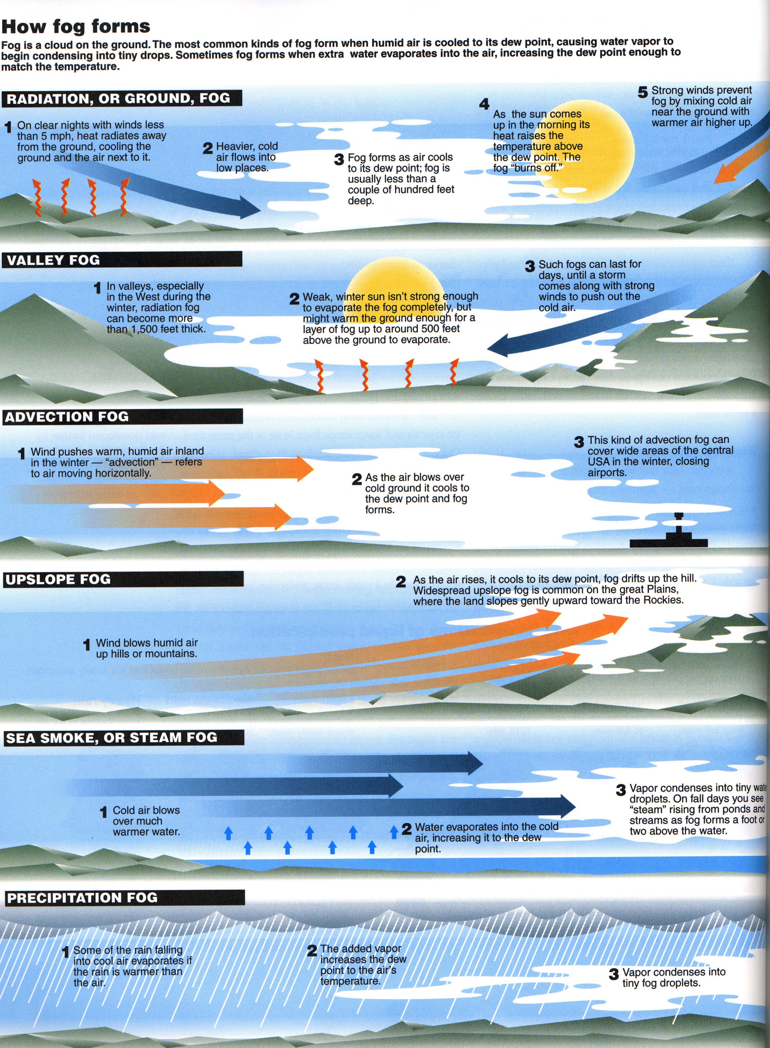
MIST AND FOG
Both are visible aerosols consisting of tiny water droplets or ice crystals suspended in the air at the surface. They are considered a type of low-lying cloud and are heavily influenced by local topography and weather conditions. The only contrast between the two is that fog reduces visibility to less than 1 kilometre, whereas mist causes lesser impairment of visibility.
Mist and fog form when the difference between air temperature and dew point is less than 2.5°C. For mist or fog to form there must be water vapour present in the air. There are several ways by which water vapour is added to the air. These include precipitation, evaporation from the surface of oceans, water bodies or wet land and transpiration from plants. Water vapour begins to condense on condensation nuclei such as dust and salt. Fog normally occurs when the relative humidity reaches 100%. This is reached either by added moisture in the air or falling air temperature.
Fog can form in a number of ways, depending on how the cooling that caused the condensation occurred.
- Radiation fog is formed by the cooling of land after sunset by infrared thermal radiation in calm conditions with a clear sky. The cooling ground then cools adjacent air by conduction, causing the air temperature to fall and reach the dew point, forming fog. Radiation fog occurs at night, and often does not last long after sunrise. Radiation fog is most common in autumn and early winter.
- Advection fog occurs when moist air passes over a cool surface by advection (wind) and is cooled. This causes the moist air to cool down. For this type of fog to form, the wind must be light. The light wind allows air to slide slowly over the cooler area of land or sea increasing the chances of saturation and condensation. Normally, this fog dissipates as it moves inland, away from the sea or water bodies.
- Frontal fog forms when raindrops, falling from relatively warm air above a frontal surface, evaporate into the cooler air below.
- Up slope fog occurs when forms when moist air is pushed up the slope of a mountain or hill, causing it to cool down and condense.
0 comments
Write a comment