ENGLISH/INGLIŻ
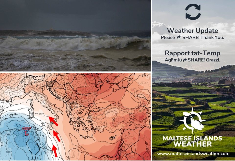
The meteorological situation across the central Mediterranean is about to intensify. The coming days will see Malta continue to find itself sandwiched in between strengthening opposing pressure systems. Whilst a low pressure system over Tunisia will deepen, an anticyclone over eastern Europe will strengthen. This will cause the spell of Sahara Desert weather to linger on and intensify. Astronomical winter come to an end on Sunday 20/3. We’ll be experiencing this mainly from late on Thursday 17/3 through to early on Monday 21/3. The effects will be as follows:
Wind: The Sirocco will strengthen. The term Sirocco is an all-inclusive name given to hot and subsequently humid southeast to southwest winds originating over northern Africa and flowing into the southern Mediterranean basin. Siroccos occur in advance of a low pressure system moving eastward across the southern Mediterranean Sea or northern Africa. Air from high pressure over the Sahara Desert rushes in to fill this low pressure system. The wind will be mainly from the- East Southeast to East. It will reach Force 8 at times. A warning will provide all the details about this.
Wehttps://polska-ed.com/kupic-generic-cialis. Weather: The sky will be predominantly overcast. The air will be hazy at times due to airborne fine desert sand. This dust will be deposited in the rain showers that will affect the Maltese Islands from time to time. Rain is more likely on Saturday 19/3 and Sunday 20/3.
Temperature: Temperatures will once again drop to below average. Temperatures will fall gradually as the weekend progresses, with the cold being more profound at the start of next week. The maximum temperature on Sunday 20/3 may struggle to reach 11°C. Minimum temperatures will dip to as low as 7°C. The air will feel colder due to the strong wind.
We will update you regularly.
MALTI / MALTESE
Is-sitwazzjoni meterjoloġika madwar iċ-ċentru tal-Mediterran se tkun qed tintensifika. Fil-jiem li ġejjin, Malta se tkun maqbuda bejn żewġ sistemi atmosferiċi opposti li kull ma jmur se jkunu qed jintensifikaw. Filwaqt li pressjoni baxxa fuq it-Tuneżija se ssir iżjed tempestuża, antiċklun fuq il-lvant ta’ l-Ewropa se jkun qed jissaħħaħ. Dan se jwassal biex il-perjodu ta’ temp sinonimu mad-Deżert tas-Sahara jippersisti u jżid. L-istaġun tax-xitwa jasal fi tmiemu nhar il-Ħadd 20/3. Dan se nesperjenzawh l-aktar minn tard il-Ħamis 17/3 sa kmieni t-Tnejn 21/3. L-effetti se jkunu kif deskritt:
Riħ: Ir-riħ Sirocco se jitqawwa. It-terminu Sirocco jinkludi fih ir-riħ jaħraq u umdu mill-Lbiċ u x-Xlokk li joriġina fl-Afrika ta’ Fuq u jonfoħ fuq in-nofsinhar tal-Mediterran. Arja minn pressjoni għolja fuq is-Sahara tonfoħ lejn pressjoni baxxa fuq in-naħa t’isfel tal-Mediterran jew l-Afrika ta’ Fuq. Din id-darba r-riħ se jkun l-aktar mix-Xlokk il-Lvant għal Lvant. Se jilħaq Forza 8 kultant. Twissija li se toħroġ aktar tard se tagħti d-dettalji kollha.
Temp: Is-sema se jkun il-biċċa l-kbira ċlampu. L-arja se tkun imdaħħna minħabba trab fin fl-ajru. Ix-xita li se tagħmel minn ħin għal ieħor se tkun tal-ħamrija. L-ogħla ċans ta’ xita bħalissa huwa nhar is-Sibt 19/3 u l-Ħadd 20/3.
Temperatura: It-temperaturi se jerġgħu jaqgħu taħt il-medja. It-temperaturi se jonqsu gradwalment fi tmiem il-ġimgħa, bil-kesħa tinħass l-aktar matul il-bidu tal-ġimgħa li ġejja. It-temperatura massima nhar il-Ħadd 20/3 se tbati biex tilħaq 11°C. It-temperaturi minimi kapaċi jmissu 7°C. L-arja se tinħass kiesħa ferm minħabba r-riħ qawwi.
Se nżommukhom aġġornati regolarment.
0 comments
Write a comment