
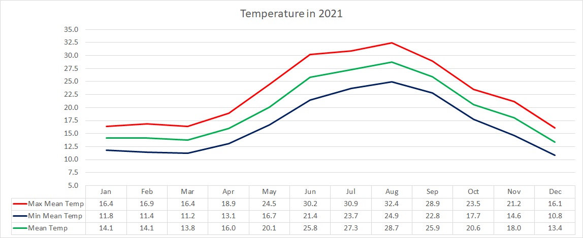
Air Temperature
| Highest Maximum | 40.8°C | 20th June 2021 |
| Lowest Maximum | 10.2°C | 15th February 2021 |
| Highest Minimum | 27.7°C | 5th August 2021 |
| Lowest Minimum | 5.9°C | 15th February 2021 |
| Mean Maximum | 23.0°C |
| Mean Minimum | 16.7°C |
| Mean | 19.8°C |
Relative Humidity
| Lowest Relative Humidity | 18% | 28th June 2021 |
| Mean Relative Humidity | 74.1% |
Atmospheric Pressure
| Highest Atmospheric Pressure | 1035.2hPa | 23rd February 2021 |
| Lowest Atmospheric Pressure | 998.3hPa | 21st March 2021 |
| Mean Atmospheric Pressure | 1018.6hPa |
Wind
| Highest Gust | 78.9 km/h (Force 9) | 7th February 2021 |
| Mean Wind Speed | 17.3 km/h |
| Most Frequent Wind Direction | Northwest |
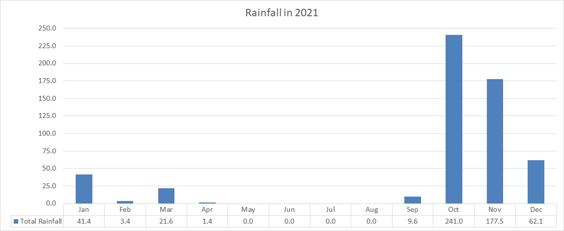
Precipitation
| Total Rainfall During 2021 | 558.0 mm |
| Highest 24 Hour Total | 69.5 mm | 3rd October 2021 |
| Rain Days | 80 days |
| Thunderstorm Days | 27 days |
| Hail Days | 13 days |
Rainfall Events
| 01/01/2021 | 0.6 mm | P.M. Shower |
| 02/01/2021 | 8.5 mm | Isolated Thunderstorm |
| 03/01/2021 | 4.3 mm | P.M. Rain/Hail Showers; Distant Thunder |
| 04/01/2021 | 3.2 mm | A.M. Rain/Hail Showers; Distant Thunder |
| 08/01/2021 | 0.3 mm | Isolated Light Rain |
| 12/01/2021 | 2.3 mm | Rain/Hail Showers |
| 13/01/2021 | 0.5 mm | Light Rain |
| 14/01/2021 | 0.3 mm | Light Rain |
| 15/01/2021 | 1.5 mm | Isolated Shower |
| 16/01/2021 | 1.7 mm | Isolated Rain/Hail Shower |
| 17/01/2021 | 1.6 mm | Isolated Shower (Hailstorm in Malta) |
| 18/01/2021 | 2.1 mm | Shower |
| 23/01/2021 | 0.3 mm | Light Rain |
| 24/01/2021 | 0.3 mm | Light Rain |
| 26/01/2021 | 5.9 mm | Showers |
| 27/01/2021 | 0.5 mm | Light Rain |
| 28/01/2021 | 7.2 mm | Showers |
| 31/01/2021 | 0.3 mm | Light Rain |
| 02/02/2021 | 1.8 mm | Isolated Shower |
| 13/02/2021 | 1.1 mm | Light Rain |
| 14/02/2021 | 0.5 mm | Light Rain |
| 08/03/2021 | 1.3 mm | Light Rain |
| 09/03/2021 | 0.3 mm | Light Rain |
| 10/03/2021 | 0.9 mm | Light Rain |
| 16/03/2021 | 3.7 mm | Isolated Showers; Thundery Shower with Hail |
| 18/03/2021 | 3.6 mm | Isolated Showers |
| 20/03/2021 | 0.5 mm | Light Rain (with heavy sand deposits) |
| 21/03/2021 | 4.6 mm | Showers |
| 22/03/2021 | 0.8 mm | Light Rain |
| 23/03/2021 | 5.6 mm | Showers; Thundery Shower with Hail |
| 30/03/2021 | 0.3 mm | Dew |
| 05/04/2021 | 1.4 mm | Isolated Shower |
| 04/09/2021 | 3.6 mm | Thunderstorm |
| 06/09/2021 | 1.5 mm | Isolated Thunderstorm |
| 09/09/2021 | 2.6 mm | Isolated Shower; Distant Thunder |
| 10/09/2021 | 1.5 mm | Isolated Shower; Distant Thunder |
| 11/09/2021 | 0.4 mm | Isolated Shower |
| 02/10/2021 | 32.1 mm | Thunderstorm; Hail |
| 03/10/2021 | 69.5 mm | Thunderstorm; Hail |
| 05/10/2021 | 2.4 mm | P.M. Isolated Thunderstorm |
| 06/10/2021 | 3.0 mm | A.M. Isolated Thunderstorm |
| 07/10/2021 | 1.2 mm | Isolated Showers |
| 08/10/2021 | 2.1 mm | Isolated Showers |
| 09/10/2021 | 0.3 mm | Isolated Showers |
| 10/10/2021 | 3.7 mm | Isolated Showers; Distant Thunder |
| 12/10/2021 | 0.4 mm | Isolated Showers |
| 14/10/2021 | 34.5 mm | Steady Rain; Thunder |
| 15/10/2021 | 0.5 mm | Isolated Showers |
| 16/10/2021 | 0.2 mm | Light Rain |
| 18/10/2021 | 1.0 mm | Isolated Showers; Distant Thunder |
| 25/10/2021 | 24.1 mm | P.M. Steady Rain; Thunder |
| 26/10/2021 | 39.7 mm | A.M. Steady Rain; Thunder; P.M. Showers |
| 27/10/2021 | 11.9 mm | Showers |
| 28/10/2021 | 2.8 mm | Isolated Showers |
| 29/10/2021 | 4.6 mm | Light Rain |
| 30/10/2021 | 0.3 mm | Light Rain |
| 31/10/2021 | 6.7 mm | Light Rain; P.M. Steady Rain |
| 01/11/2021 | 19.9 mm | Thunderstorm |
| 08/11/2021 | 0.3 mm | Light Rain |
| 09/11/2021 | 2.8 mm | Showers |
| 11/11/2021 | 48.8 mm | Heavy Thunderstorm; Hail |
| 15/11/2021 | 2.5 mm | Isolated Shower |
| 22/11/2021 | 2.8 mm | Showers; Distant Thunder |
| 25/11/2021 | 61.3 mm | Heavy Thunderstorm; Hail |
| 27/11/2021 | 3.3 mm | Showers; Distant Thunder |
| 28/11/2021 | 30.7 mm | Steady Rain; Thunder |
| 29/11/2021 | 4.1 mm | Showers |
| 30/11/2021 | 1.0 mm | Isolated Shower |
| 02/12/2021 | 0.3 mm | Light Rain |
| 03/12/2021 | 29.9 mm | Steady Rain; Distant Thunder |
| 04/12/2021 | 2.4 mm | Showers |
| 05/12/2021 | 1.5 mm | Isolated Showers |
| 06/12/2021 | 4.3 mm | Showers; Hail |
| 09/12/2021 | 3.1 mm | Isolated Showers; Hail |
| 10/12/2021 | 0.3 mm | Light Rain |
| 11/12/2021 | 16.4 mm | Intermittent Light Rain; Hail |
| 12/12/2021 | 0.3 mm | Light Rain |
| 16/12/2021 | 2.8 mm | Isolated Showers |
| 23/12/2021 | 0.5 mm | Light Rain |
| 28/12/2021 | 0.3 mm | Light Rain |
2021 Compared to the Climate Means
| Climate Mean | 2021 | Anomaly | |
| Mean Maximum Temperature | 20.8°C | 23.0°C | +2.2°C |
| Mean Minimum Temperature | 15.6°C | 16.7°C | +1.1°C |
| Mean Temperature | 18.2°C | 19.8°C | +1.6°C |
| Mean Relative Humidity | 76% | 74.1% | -1.9% |
| Mean Atmospheric Pressure | 1016.5hPa | 1018.6hPa | +2.1hPa |
| Mean Wind Speed | 16.4 km/h | 17.3 km/h | +0.9 km/h |
| Most Frequent Wind Direction | West Northwest | Northwest | +22.5° |
| Total Rainfall | 585.6 mm | 558.0 mm | -27.6 mm |
| Total Rain Days | 84 days | 80 days | -4 days |
| Total Thunderstorm Days | 26 days | 27 days | +1 day |
| Total Hail Days | 8 days | 13 days | +5 days |
Month-by-Month Summary for 2021
January 2021 – Warmer and Drier (REGISTERS WARMEST EVER JANUARY DAY)
February 2021 – Warmer and Drier (AMONG THE DRIEST ON RECORD)
March 2021 – Cooler and Drier
April 2021 – Cooler and Drier
May 2021 – Warmer and Drier
June 2021 – Warmer and Drier (THIRD HOTTEST ON RECORD)
July 2021 – Warmer with Average Rainfall
August 2021 – Warmer and Drier
September 2021 – Warmer and Drier
October 2021 – Cooler and Wetter (AMONG THE WETTEST ON RECORD)
November 2021 – Warmer and Wetter
December 2021 – Cooler and Drier
2021: A Year of Meteorological Extremes
2021 was an eventful year. It was a year of extremes.
2021 was warmer than normal. With a mean temperature of 19.8˚C, the annual average was exceeded by 1.6˚C. The greatest difference from the climate mean was recorded in maximum temperatures. The months of March, April, October and December were the only ones with temperatures below the norm. A number of temperature-related records were broken over the course of last year. Saturday 9th January, on the second weekend of 2021, broke Malta’s national record for the warmest temperature ever measured in January. A very warm air mass advecting across the central Mediterranean from the Sahara Desert caused the temperature at our weather station in Għarb to shoot up to 23.6°C. An even warmer value of 25.8°C was measured at the airport in Luqa. That same day also broke the record for the warmest January night ever. The minimum air temperature that day dipped to only 17.1°C. The corresponding value at the airport in Luqa was of 19.4°C. More records were to fall in June. With a monthly average temperature of 25.8°C, June 2021 was a solid 2.0°C hotter than the climate norm. It was also the third hottest June on record in the Maltese Islands. Only those of 2019 and 2003 were hotter. A heat wave that characterized the meteorological scene in June broke records as well. Lasting from 20th June through to 30th June (both days included), it ended up being the longest heatwave experienced locally. The previous record of 10 days was set in August 2017. The heat wave’s final day, 30th June, was to break the record for the hottest June day ever. The temperature at our weather station in Għarb soared to 40.8°C on that day. An even higher value of 41.5°C was recorded at Malta International Airport. This heatwave occurred as a result of a heat dome. A heat dome is a phenomenon in which high-pressure atmospheric conditions trap air coming in from the Sahara Desert. The trapped air heats up at an alarming rate as it is compressed, like what happens under the lid on a saucepan. In normal conditions, winds are able to move a heat dome around, but because this particular heat dome stretched high into the atmosphere, it wasn’t easy to move about. This led to the persistent heatwave. The heat dome caused air pollution, desert sand and moisture to become stagnant, leading to a choked up atmosphere.
The coldest night of 2021 came in mid-February. The thermometer dipped to a chilly 5.9˚C on 15th February. This was during one of two brief cold snaps experienced in 2021.
2021 was a an average year in terms of rainfall when viewed overall. A total of 558 mm was measured. That is only marginally below the climate average. More records were to be broken where rainfall is concerned. Rainfall was below average in a staggering ten months. Only 77.4 mm (or just under 14%) of the total rainfall in 2021 was measured over the course of the first nine months. Rain particularly scarce in February 2021. In fact, it was among the driest ever Februaries. Some places around the Maltese Islands did not see a drop of rain from 5th April through to 4th September 2021. No rain was registered in a number of localities for a total of 151 consecutive days. The months of October and November accounted for three quarters (or 428.1 mm) of the total rainfall measured throughout the entire year. October 2021, by far last year’s wettest month, became the third wettest October since record keeping began a century earlier. From early October 2021 throughout to mid-December 2021, the Maltese Islands experienced frequent rainy episodes (43 days of rain), with at least eight of these being events of very heavy rainfall. A handful of storms dumped in excess of 100 mm of rain over a number of localities. The ones which struck in the early hours of 3rd October, 11th November and 25th November were particularly dangerous. Cars were carried away by flash floods, and people had to be rescued from the flooding. The autumn of 2021 was the wettest in over 20 years. The very warm sea that surrounded the Maltese Islands after the very warm summer played an important part in creating an excessively wet autumn. As summer transitioned into autumn, cooler air from over Europe started infiltrating the central Mediterranean. The sharp difference between local and incoming air greatly destabilized the atmosphere above the Maltese Islands, leading to the formation of successive vigorous bad weather systems. In addition to this, a greater amount of moisture was available to be advected into these systems as a result of the very warm sea, leading to larger amounts of rainfall.
Averaging at 17.3 km/h, the wind was marginally stronger than in a typical year. The highest gust last year was registered at 78.9km/h from the Northwest, during a gale on 7th February.
Overall, the average atmospheric pressure was slightly higher than the norm. The first half of the year was dotted by a series of blocking anticyclones. These are areas of high pressure that remain stationary over an area for several weeks. Bringing long days of uninterrupted bright sunshine, these anticyclones were responsible for the dry weather experienced at the start of 2021. The highest value of atmospheric pressure was recorded on the 23rd of February. It reached 1035.2hPa. The lowest value of atmospheric pressure registered, on the other hand, was on 21st March. It dropped to 998.3hPa, as an intense low pressure system traversed the central Mediterranean.
0 comments
Write a comment