Updates

For the latest updates related to the weather in the Maltese Islands. So keep yourself updated by visiting this page frequently or like our Facebook page.

Updates

This week: An unstable start, but summer returns by Wednesday

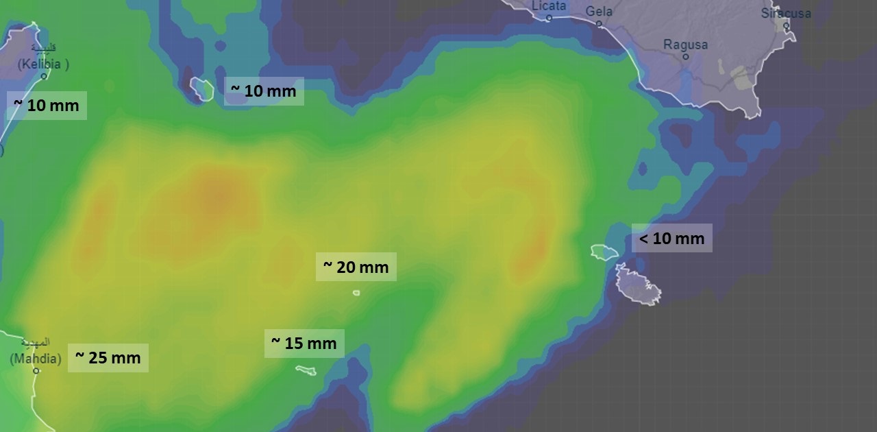
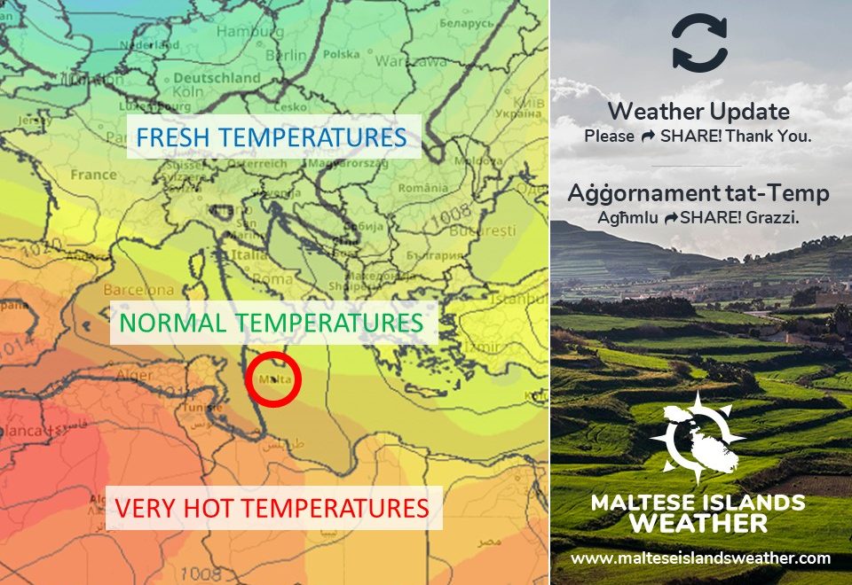
Continued instability will characterise our weather on the first two days of the week. Monday should see further showers possibly heavy and thundery at times. These will decrease in frequency and intensity over time, before coming to an end by late on Tuesday. High pressure will once again take control of the central Mediterranean then. Mainly sunny or partly cloudy skies will dominate from Wednesday. With the exception of Monday, we will again experience 30°C / 31°C highs and 23°C / 24°C lows. The wind from the East to Northeast will be rather strong at the start of the week, reaching Force 4/5 on Monday and Force 5/6 on Tuesday. It is likely to become mainly light by Wednesday, and become mainly from the westerly quadrant. Humidity will also spike by Wednesday causing the air to feel warmer and heavier.

Updates

Instability to intensify / L-instabilita se tintensifika

ENGLISH/INGLIŻ

All rain so far has been largely localised, with only a handful of localities around the Maltese Islands receiving any significant rainfall. Things are to about to change though. An area of instability will come to settle above the central Mediterranean for at least 48 hours. For some two days, on Sunday 13/09 and Monday 14/09, more widespread instability will be experienced all around the Maltese Islands. Upon passing over the very warm sea around our islands, the mass of clouds associated with this zone of instability will be charged by moisture. As a result of this, a series of showers and thunderstorms will develop. The most intense of these are likely to be concentrated at sea between Malta and Libya. Whilst showers which may be heavy and thundery at times are possible at any time on both days, the greatest chance of rain will be from a potentially strong thunderstorm that should develop around the Maltese Islands at some point between late afternoon on Sunday 13/09 and early morning on Monday 14/09. The sky will still be mainly sunny or partly cloudy at times, so don’t let this lead you to believe that the bad weather has missed us. Further updates will be provided when and if necessary.


MALTI / MALTESE

Ix-xita li għamlet sa issa kienet lokaliżżata ferm, bi ftit lokalitajiet biss madwar il-Gżejjer Maltin jaraw xita sinifikanti. Is-sitwazzjoni se tinbidel pero. Roqgħa ta’ instabilita se tkun preżenti fuq iċ-ċentru tal-Mediterran għal xi 48 siegħa. Għal jumejn, il-Ħadd 13/09 u t-Tnejn 14/09, se jkun hawn instabilita estensiva madwar il-Gżejjer Maltin. Il-fwar abbundanti li hawn fl-arja, kaġun ta’ baħar sħun madwarna, se jwassal biex il-maltemp abbinat ma’ din l-instabilita jintensifika aktar. Se jiżviluppaw serje ta’ ħalbiet tax-xita u maltempati bir-ragħad. L-aktar qawwijin minn dawn se jkunu kkonċentrati fuq il-baħar bejn Malta u l-Libja. Filwaqt li ħalbiet tax-xita li jistgħu jkunu qawwijin u bir-ragħad kultant huma possibli matul il-jumejn li huma kollha, qed inħarsu b’mod partikolari lejn maltempata potenzjalment qawwija li għandha tifforma madwarna f’xi ħin bejn tard wara nofsinhar il-Ħadd 13/09 u kmieni filgħodu t-Tnejn 14/09. Navżawkom li s-sema se jkun il-biċċa l-kbira xemxi jew ftit imsaħħab kultant. Importanti li ma tħallux dan il-fatt iqarraq bikom u taħsbu li l-maltemp qabiżna. Aktar aġġornamenti se jsegwu x’ħin u jekk ikun hemm il-bżonn.

Updates

3 Hourly Forecast for Victory Day (08/09/2020)

00:00 to 03:00 – mainly clear or partly cloudy; 25°C to 24°C; Southeast to East Force 2/3
03:00 to 06:00 – mainly clear or partly cloudy; 24°C to 23°C; East Force 2/3
06:00 to 09:00 – mainly clear or partly cloudy; 23°C to 27°C; East Force 2/3
09:00 to 12:00 – mainly clear or partly cloudy; 27°C to 30°C; East Force 2/3 to 3/4
12:00 to 15:00 – mainly clear or partly cloudy; 30°C to 31°C; East Force 3/4
15:00 to 18:00 – mainly clear or partly cloudy; 31°C to 27°C; East Force 3/4 to 2/3
18:00 to 21:00 – mainly clear or partly cloudy; 27°C to 26°C; East to Northeast Force 2/3
21:00 to 00:00 – mainly clear or partly cloudy; 26°C to 25°C; Northeast Force 2/3

Victory Day recalls the end of three historical sieges: the Great Siege of Malta by the Ottoman Empire ending in 1565, the Siege of Valletta by the French Blockade ending in 1800, and, the Siege of Malta during the Second World War by the Italian army ending in 1943. This day also coincides with the commemoration of the birth of the Virgin Mary, better known as the Nativity, which is celebrated in the villages of Senglea, Naxxar and Mellieha in Malta, and Xagħra in Gozo. The traditional regatta featuring boat races in the Grand Harbour is held on Victory Day.

Updates

This week: Some unstable days, but summer to stay

Some days will be characterised by instability, but the feeling of summer will prevail throughout this week. Daytime highs will range from 29°C to 32°C. Nighttime lows will be in the region of 23°C / 24°C. Both are warmer than the average for this time of year. The high levels of relative humidity on some days will make for even warmer values of real feel. The wind will blow the easterly quadrant for much of the time this week. The wind will be mainly light to moderate throughout. Monday 07/09 will be affected by a weakening zone of instability that will migrate from over Tunisia towards the northeast. This may bring a few showers to the Maltese Islands. Another zone of instability is likely to develop across the central Mediterranean by the following weekend. It’s still far too early to know how this will affect the Maltese Islands, but it’s safe to safe we may at least a bit of rain. The rest of the days will see mainly sunny to partly cloudy skies.

Updates

Some rain possible / Possibilita ta’ xita

ENGLISH/INGLIŻ

A zone of instability that has prevailed over Tunisia in the past few days will drift very slowly to the northeast as it weakens. It will pass close to the Maltese Islands, off Gozo’s northwest coast, as it does so. As a result, we may get a taste of some rain. The chance of rain, although still at 55%, will be higher in the morning on Monday 07/09. The possibility is for a few showers as the edge of the instability scrapes past the Maltese Islands. Some thunder is also possible. The bulk of the bad weather is likely to stay out at sea. Gozo is at a greater advantage of getting any rain. The wind will be at Force 4/5 from the Southeast to South at the time. Follow-up updates will be issued on our page when and if necessary.


MALTI / MALTESE

Żona ta’ instabbilita li kien ilha dawn l-aħħar jiem tippersisti fuq it-Tuneżija ser tersaq bilmod lejn il-Grigal filwaqt li tidgħajjef. Se tgħaddi qrib tal-Gżejjer Maltin, fuq il-baħar lejn il-majjistral ta’ Għawdex. Għal din ir-raġuni jaf induqu xi ftit xita. Iċ-ċans ta’ xita, għalkemm xorta waħda f’livell ta’ 55%, ikun l-ogħla matul filgħodu tat-Tnejn 07/09. Il-possibilita hija ta’ xi ħalbiet ta’ xita hekk kif it-tarf nett ta’ din l-instabilita tgħaddi bi żbrixx minn magħna. Xi ragħad huwa possibli wkoll. L-aqwa ta’ dan il-maltemp għandu jibqa fuq il-baħar. Għawdex huwa f’vantaġġ aħjar ta’ xi xita. Ir-riħ se jkun ta’ Forza 4/5 mix-Xlokk għal Nofsinhar f’dak il-ħin. Aktar aġġornamenti jsegwu fuq il-paġna tagħna x’ħin u jekk ikun hemm il-bżonn.

EN: The zone of instability will be centred over the Sicilian Channel to the northwest of the Maltese Islands. Its edge will be over or close to our islands. As a result, one or two showers are possible, with Gozo being at an advantage.                                                                  MT: Iż-żona ta’ instabilita se tkun iffukata fuq il-Fliegu ta’ Sqallija lejn il-majjistral tal-Gżejjer Maltin. It-tarf ta’ din se jkun fuq jew qrib il-gżejjer tagħna. Għalhekk, xi ħalba jew tnejn ta’ xita huma possibli, b’Għawdex ikun f’vantaġġ aħjar.

Updates

No major bad weather / L-ebda maltemp kbir

ENGLISH/INGLIŻ

The atmosphere above the central Mediterranean will remain unstable till at least Saturday 05/09. This instability shouldn’t affect the Maltese Islands much. Whilst the sky is still expected to be mostly cloudy at times till late on Saturday, the vast majority of showers and thunderstorms will be restricted over Tunisia and Sicily. Only a few isolated ones should be able to reach us. A shower is more possible in the morning on Thursday 03/09 and in the morning on Saturday 05/09. Nothing serious is being anticipated though. In fact, the chance of rain is still varying from 45% to 65%, and as a result, remaining dry is a possibility. Being of Sahara Desert origins, fine desert sand may be deposited with any rain. The situation will improve substantially on Sunday 06/09, with next week likely starting on a sunny note. We will update when and if necessary.


MALTI/MALTESE

L-atmosfera fuq iċ-ċentru tal-Mediterran se tibqa instabbli sa minn ta’ l-anqas is-Sibt 05/09. Din l-instabbilita’ ma tantx se taffetwa lill-Gżejjer Maltin, pero’. Għalkemm is-sema se jkun il-biċċa l-kbira msaħħab f’xi ħinijiet sa tard is-Sibt, il-maġġoranza tal-ħalbiet tax-xita u maltempati bir-ragħad se jżommu fuq it-Tuneżija u Sqallija. Xi waħdiet iżolati biss jaf jilħquna. Ħalba xita hija aktar possibbli l-Ħamis 03/09 filgħodu u s-Sibt 05/09 filgħodu. Mhux qed nistennew affarijiet kbar, pero’. Fil-fatt, iċ-ċans ta’ xita għadu jvarja bejn 45% u 65%, u għalhekk, li nibqgħu xotti hija possibilita’. Peress li din ix-xita se tkun qed toriġina fuq id-deżert, jaf tkun xi ftit tal-ħamrija. Is-sitwazzjoni se taqleb għal aħjar il-Ħadd 06/09, bil-ġimgħa li ġejja probabilment tibda fuq nota xemxija. Aħna naġġornawkhom meta u jekk ikun hemm bżonn.

Updates

This week: Some midweek instability

The last time any rain was measured in the Maltese Islands was 41 days ago, when a heavy rain shower produced up to 30.5 mm in localised areas. Some instability may bring some rain to our shores this week. Cooler air aloft will drift towards the central Mediterranean by midweek. This is likely to destabilise the atmosphere above our region, especially when considering the contrast it will create with the very warm sea around the Maltese Islands. The unstable atmosphere, which will likely develop an area of showers and thunderstorms across parts of the central Mediterranean, will be centred over southern Italy. If conditions are right, rain could reach the Maltese Islands too. The chance of rain is highest on Wednesday 02/09 and Thursday 03/09. The chance of rain continues to vary between 45% and 65%. Expected total rainfall is also varying widely, with low amounts being more probable. If it does rain, it will probably be isolated, with some localities probably remaining completely dry. Updates will be issued on our site when and if necessary. The rest of the week is set to feature mainly sunny or partly cloudy skies. With a 34°C high and 25°C low, Monday 31/08 will be this week’s hottest day clique neste link. Temperatures will then dip from Tuesday 01/09, with 30°C / 31°C highs and 22°C / 23°C lows on all remaining days. Whilst the wind direction will change almost daily, most days will be characterised by a mainly light to moderate wind.


Updates

This week: Seasonal temperatures throughout

With an average maximum temperature of 32.2°C and an average minimum temperature of 24.4°C, August 2020 has so far been 1.3°C warmer than average. We can now safely say that the peak of summer is behind us. A weaker anticyclone across the Mediterranean will mean that cooler air from over Europe will be able to reach us far more easily. Temperatures will be very stable. Daytime highs will be at 31°C / 32°C on all days this week. All nights will feature lows of 23°C / 24°C. These temperatures will be line with the climate average for this time of year. Breezy winds are likely during the first half of the week ed-hrvatski.com. These are forecast to weaken as the week progresses. The wind’s expected to blow mainly from the West on weekdays, before veering South during the weekend. All days this week will be characterised by sunny to mainly sunny skies.

Updates

Normal temperatures from Sunday 23/08? / Temperaturi normali mill-Ħadd 23/08?

With an average maximum temperature of 32.2°C and an average minimum temperature of 24.4°C, August 2020 has so far been 1.3°C warmer than average. This is about to change slightly, however. Starting on Sunday 23/08, temperatures will be much closer to average in the Maltese Islands. Most days will be characterised by maximum temperatures in the region of 30°C to 32°C and minimum temperatures of 22°C / 23°C. This state of affairs will likely be consistent in the long-term. That is still considered hot, but will still be a welcome relief from the intense above-average heat that has gripped the Maltese Islands for much of this month. This comes as most models are suggesting a weakening trend in the anticyclone that has pushed successive plumes of hot air from north Africa in the past weeks. This will leave us with temperatures that are more typical of this time of year. The weather is still going to be fine on most days. No significant rain is expected before September. With the exception of one or two days, the wind will continue to be predominantly light.

B’medja massima ta’ 32.2°C u medja minima ta’ 24.4°C, Awwissu 2020 sa issa kien 1.3°C aktar sħun mill-medja. Dan għandu jinbidel xi ftit, pero’. Minn nhar il-Ħadd 23/08 ‘il quddiem, it-temperaturi se jkunu aktar qrib il-medja. Il-maġġoranza tal-jiem se jaraw temperaturi massimi minn 30°C sa 32°C u temperaturi minimi ta’ 22°C / 23°C. Sa issa jidher li din is-sitwazzjoni se tkun konsistenti fit-tul. It-temperaturi xorta waħda se jibqgħu sħan, pero’ xorta waħda se jagħtu xi ftit soljev mis-sħana intensa li ħakmet lill-pajjiżna għal ħafna minn dan ix-xahar. Dan wara li diversi mapep qed jindikaw li l-antiċiklun li ġabilna masses konsekuttivi ta’ arja sħuna minn l-Afrika ta’ fuq se jkun qed jidgħajjef daqsxejn. Dan iwassal għal temperaturi mal-medja. It-temp xorta waħda se jibqa sabiħ f’ħafna mill-ġranet. Jidher ukoll li mhux qed nistennew xita sinifikanti qabel Settembru. Ħlief għal xi jum jew tnejn, ir-riħ se jibqa jkun il-biċċa l-kbira ħafif.

Updates

This week: Remaining rather hot

Although the heat will be less intense than now, the coming week will still be rather hot. An anticyclone that has extended to cover much of the Mediterranean is set to stand its ground. All days this week will be characterised by sunny to mainly sunny skies. The wind will blow mainly from the West, with most days set to be characterised by light winds. Tuesday 18/08 may be fairly breezy, however. Temperatures should remain above average on all days, with Thursday 20/08 being the only likely exception. Maximum temperatures will hover at 33°C to 35°C on six of seven days schweiz-libido.com. It will be around 31°C on Thursday 20/08. Nighttime lows will dip slightly, from around 26°C / 27°C towards the start of the week to 23°C / 24°C by the weekend.