Updates

For the latest updates related to the weather in the Maltese Islands. So keep yourself updated by visiting this page frequently or like our Facebook page.

Updates

STRONG WIND WARNING / TWISSIJA TA’ RIĦ QAWWI

ENGLISH/INGLIŻ

An intense cold front will traverse the central Mediterranean in the early hours of Monday 12/10. This will generate a strong Northwest wind. This strong wind warning is valid from 03:00 on Monday 12/10 till 06:00 on Tuesday 13/10. This warning could be extended if necessary. The details below indicate how the situation will develop over this time period:

Monday 12/10 

03:00 to 06:00 – Wind will increase rapidly from Northwest Force 2/3 to 6/7. This sudden increase in wind may be accompanied by a heavy thundery shower in areas.

06:00 to 09:00 – Northwest Force 6/7 to 5/6

09:00 to 12:00 – Northwest Force 5/6

12:00 to 15:00 – Northwest Force 5/6

15:00 to 18:00 – Northwest Force 5/6

18:00 to 21:00 – Northwest Force 5/6 to 6/7

21:00 to 00:00 – Northwest Force 6/7

Tuesday 13/10

00:00 to 03:00 – Northwest Force 6/7

03:00 to 06:00 – Northwest Force 6/7 to 5/6

The peak gusts are set to blow across the Maltese Islands around midnight from Monday 12/10 into Tuesday 13/10. They could reach Force 8 across exposed areas of the Maltese Islands.

The wind will remain strong for much of the week, reaching Force 5/6 at some point on all days till at least Saturday 17/10. Further warnings will be issued if deemed necessary.

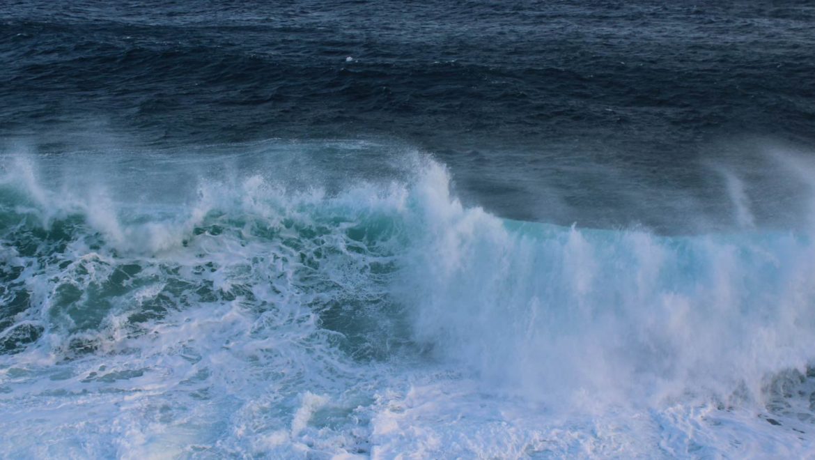
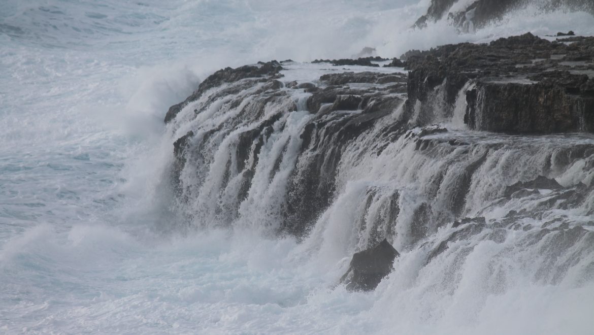
The sea will be rough to very rough, with a significant wave height of 3 metres from the Northwest. Waves of up to 4.5 metres are possible during peak gusts. The swell will be a low Northwest. The map below indicates the stretch of coastline most exposed to this strong wind and rough sea.


MALTI / MALTESE

Front ta’ arja kiesħa intens se jgħaddi minn fuq iċ-ċentru tal-Mediterran fis-segħat bikrijin tat-Tnejn 12/10. Dan se jiġġenera riħ qawwi mill-Majjistral. Din it-twissija ta’ riħ qawwi se tkun fis-seħħ minn 03:00 tat-Tnejn 12/10 sa 06:00 tat-Tlieta 13/10. Jaf tkun estiża jekk ikun hemm il-bżonn. Id-dettalji t’hawn taħt jindikaw kif se tiżviluppa s-sitwazzjoni matul dan il-ħin:

It-Tnejn 12/10 

03:00 sa 06:00 – Ir-riħ se jitqawwa f’ħin qasir minn Majjistral Forza 2/3 għal 6/7. Din iż-żieda f’daqqa ta’ riħ tista tkun abbinata ma’ ħalba xita bir-ragħad qawwija f’xi nħawi.

06:00 sa 09:00 – Majjistral Forza 6/7 għal 5/6

09:00 sa 12:00 – Majjistral Forza 5/6

12:00 sa 15:00 – Majjistral Forza 5/6

15:00 sa 18:00 – Majjistral Forza 5/6

18:00 sa 21:00 – Majjistral Forza 5/6 għal 6/7

21:00 sa 00:00 – Majjistral Forza 6/7

It-Tlieta 13/10

00:00 sa 03:00 – Majjistral Forza 6/7

03:00 sa 06:00 – Majjistral Forza 5/6

Il-buffuri l-aktar qawwija se jonfħu fuq il-Gżejjer Maltin madwar nofsillejl ta’ bejn it-Tnejn 12/10 u t-Tlieta 13/10 u jafu jilħqu Forza 8 fl-inħawi fejn jaqbel l-aktar.

Ir-riħ se jibqa qawwi għal biċċa l-kbira tal-ġimgħa, u għandu jilħaq Forza 5/6 f’xi ħin kuljum sa minn ta’ l-anqas is-Sibt 17/10. Aktar twissijiet jinħarġu jekk ikun hemm il-bżonn.

Il-baħar se jkun qawwi għal qawwi ħafna, b’mewġ għoli madwar 3 metri mill-Majjistral. Mewġ sa 4.5 metri se jkun possibli fl-aktar buffuri qawwija. L-imbatt se jkun baxx mill-Majjistral. Il-mappa ta’ hawn taħt tindika l-kosta l-aktar esposta għal dan ir-riħ qawwi u baħar imqalleb.

Updates

Cool, wet and windy on Monday / Kesħa, xita u riħ għat-Tnejn

ENGLISH/INGLIŻ

An intense cold front will be moving across the central Mediterranean late at night. The front will probably reach us at some point between 03:00 and 06:00 on Monday 12/10. This will be causing an abrupt change in weather conditions locally.

Temperature

A sharp drop in temperatures will be experienced on Monday 12/10. They will dip to below 20°C when the cold front moves across at night. They will continue declining during the day, possibly going down to a chilly 14°C at some point during the day. Temperatures will recover gradually from Tuesday 13/10, with values rising to normal levels. Monday 12/10 will be really cold by local standards.

Wind

The wind will shift Northwest and suddenly start blowing strongly as soon as the cold front reaches in the very early hours of Monday 12/10. It will continue reaching Force 6/7 at times (with gusts of up to Force 8) throughout the day. It will likely be strongest in the evening. The worst of the wind will be over by Tuesday 13/10, although it will continue reaching Force 5/6 at times at some point on all days till at least Saturday 17/10. The wind direction will alternate between Northwest and Southwest.

Rain

The cold air moving in will clash with the warm sea locally, generating showers all around us. Some of these will be affecting us. Showers might be heavy, thundery and with hail at times. Rain will be possible from the very early hours of Monday 12/10 onward. In addition to the showery rain, an intense thunderstorm will be very close to the west of the Maltese Islands before dawn on Monday 12/10. This will either skim past or touch parts of our islands. A direct hit is not very likely. Residual showers from this front will linger into Tuesday 13/10. Another zone of instability may bring further showers as the week progresses.

Regular updates will be posted on our facebook page as the meteorological situation evolves.


MALTI / MALTESE

Front kiesaħ u intens se jkun qed jgħaddi miċ-ċentru tal-Mediterran tard billejl. Il-probabilita hi li dan il-front jilħaqna f’xi ħin bejn 03:00 u 06:00 tat-Tnejn 1/10. Dan se jwassal għal bidla drastika u fi ftit ħin fit-temp lokali.

Temperatura

It-temperatura mistennija taqa nhar it-Tnejn 12/10. Din se tinżel taħt 20°C mal-wasla ta’ dan il-front kiesaħ. Se tkompli tonqos matul il-jum u kapaċi tinżel sa 14°C f’xi ħin matul il-jum. It-temperaturi jirkupraw mill-ġdid minn nhar it-Tlieta 13/10, b’numri mal-medja staġġjonali. Il-jum tat-Tnejn 12/10 se jkun kiesaħ sew f’termini lokali.

Riħ

Ir-riħ se jaqleb Majjistral u jitqawwa malajr mal-wasla ta’ dan il-front kiesaħ fis-siegħat bikrija tat-Tnejn 12/10. Se jkompli jilħaq Forza 6/7 kultant (b’buffuri sa Forza 8) matul il-jum kollu. L-aqwa tiegħu se jkun filgħaxija. Għalkemm l-agħar se jkun għadda sa kmieni t-Tlieta 13/10, se jkun qed jilħaq Forza 5/6 kultant f’kull jum sa minn ta’ l-anqas is-Sibt 17/10. Id-direzzjoni tar-riħ se talterna bejn Majjistral u Lbiċ.

Xita

L-arja kiesħa abbinata ma’ dan il-front se toħloq kuntrast qawwi mal-baħar sħun madwarna, u għalhekk għandhom jiżviluppaw numru ta’ ħalbiet tax-xita. Uħud minn dawn se jaħkmuna. Ħalbiet tax-xita jistgħu jkunu qawwijin, bir-ragħad u silġ kultant. Ix-xita se tkun possibbli minn kmieni t-Tnejn 12/10 ‘il quddiem. Apparti dawn il-ħalbiet, maltempata bir-ragħad intensa se tkun qrib ħafna lejn il-punent tal-Gżejjer Maltin qabel sbieħ il-jum tat-Tnejn 12/10. Din se taqbiżna bi żbrixx jew tmiss biss xi nħawi tal-gżejjer tagħna. Mhux nistennew li taħkimna bi sħiħ. Xita residwa minn dan il-front se tibqa possibbli matul il-jum tat-Tlieta 13/10. Żoni oħrajn ta’ instabbilita jistgħu jġibu aktar ħalbiet tax-xita matul il-ġimgħa.

Aġġornamenti regolari se jsegwu fuq il-paġna ta’ facebook tagħna hekk kif is-sitwazzjoni tat-temp tiżviluppa.

Updates

This week: A gradual decline in temperatures

After an exceptionally warm start to October, temperatures will slowly turn more seasonal as the week progresses. Daytime highs will decline from 29°C at the start of the week to around 24°C by the weekend. Night times will dip from 22°C to 19°C over the course of this week. Any rainfall this week will be limited to isolated showers. If any rain does occur this will likely be localised. Remaining completely dry is a great possibility. Most days this week will be experience a partly cloudy sky. A moderate wind from the Northwest will characterise all week days. Winds will decrease over the weekend, and veer to a more southerly quadrant.

Updates

This week: A very warm start to October anticipated

After a sharp dip in temperatures over the weekend, the central Mediterranean is in for a week of warming. The rate of warming will be accelerated at the weekend, when a strong southerly wind is anticipated. Daytime highs will rise from 25°C at the start of the week to 29°C (possibly also 30°C) by the weekend. Night time lows will climb from 18°C at the beginning of the week to 24°C by its end. Whilst any significant precipitation is unlikely, one cannot rule out the possibility of one or two isolated showers towards the end of the week. It is certain, however, that most days will see plentiful bright sunshine. A light to moderate westerly wind is likely to linger into the first half of the week. We expect Wednesday through to Friday to be characterised by mainly light and variable winds. The wind will turn from the southerly quadrants for the weekend, and become rather strong at times. The low levels of humidity at the start of the week will definitely be giving way to more damp air as the days progress.

Updates

This weekend’s change in weather / It-taqliba fit-temp ta’ tmiem din il-ġimgħa

ENGLISH/INGLIŻ

A cold front associated with an intense low pressure system (989hPa) over Italy will traverse our region late on Friday 25/09. Its effects will be felt throughout the weekend, and the start of next week. A ridge of high pressure is then likely to form across the central Mediterranean by Tuesday 29/09, restoring fine weather over the Maltese Islands.

The wind will experience a sudden turn to the West Northwest and a sharp increase to Force 5/6 at times 7 at the moment the cold front moves over the Maltese Islands. This will increase further and reach Force 6/7 at times 8 all day Saturday 26/09. It will decrease to Force 4/5 at times 6 for Sunday 27/09 and Monday 28/09. A separate warning was issued for these strong winds.

The maximum temperature on Friday 25/09 peaked at 32°C, a full 4°C above the average for this time of year. As soon as the cold front crosses over us, the temperature will dip. Daytime highs over the weekend will reach only 23°C / 24°C, a full 4°C below the September average. Nighttime lows will be marginally below the climate average, at 19°C / 20°C. The strong winds will make the air feel even cooler.

Some rain may occur from time to time too, mainly between late evening on Friday 25/09 and early morning on Monday 28/09. Of particular interest to us is a thunderstorm that may form around the central Mediterranean later in the day on Sunday 27/09. As things stand, there is a chance that this may affect us. We will monitor it carefully and update you if necessary.

The weather situation will stabilise again on Tuesday 28/09 with sunnier skies, slightly warmer temperatures and lighter winds.


MALTI / MALTESE

Front ta’ arja kiesħa abbinat ma’ sistema ta’ pressjoni baxxa intensa (989hPa) fuq l-Italja se jgħaddi minn fuq ir-reġjun tagħna tard il-Ġimgħa 25/09. L-effetti ta’ dan se jinħassu tul tmiem din il-ġimgħa kollu u l-bidu tad-dieħla. Firxa ta’ pressjoni għolja għandha tiżviluppa madwarna minn nhar it-Tlieta 29/09, biex b’hekk jirritorna l-bnazzi.

Ir-riħ se jdur Punent Majjistru f’daqqa u jżid malajr għal Forza 5/6 kultant 7 malli jasal fuqna dan il-front ta’ arja kiesħa. Dan se jżid aktar u jilħaq Forza 6/7 kultant 8 matul il-jum kollu tas-Sibt 26/09. Ir-riħ imbagħad jonqos għal Forza 4/5 kultant 6 il-Ħadd 27/09 u t-Tnejn 28/09. Id-dettalji dwar dan ir-riħ qawwi ġew deskritti fi twissija separata.

L-ogħla temperatura tal-Ġimgħa 25/09 messet 32°C, 4°C ogħla mill-medja għal dan iż-żmien tas-sena. Mal-wasla tal-front kiesaħ, it-temperatura se taqa. L-ogħla fi tmiem il-ġimgħa tilħaq biss 23°C / 24°C, 4°C anqas mill-medja għal Settembru. It-temperaturi minimi ta’ 19°C / 20°C se jkunu biss ftit anqas mill-medja. Ir-riħ qawwi se jwassal biex it-temperaturi jinħassu aktar friski minn kemm verament ikunu.

Se jkun hemm ukoll il-possibilita ta’ xi ftit xita minn ħin għal ieħor, speċjalment bejn tard il-Ġimgħa 25/09 filgħaxija u kmieni t-Tnejn 28/09 filgħodu. Ta’ interess speċjali għalina hija l-possibilita ta’ maltempata bir-ragħad madwar iċ-ċentru tal-Mediterran aktar tard mal-jum tal-Ħadd 27/09. Jidher li din kapaċi tmissna. Se nżommu għajnejna fuqha u naġġornawkom kif ikun hemm bżonn.

Is-sitwazzjoni tat-temp se terġa tistabiliżża nhar it-Tlieta 28/09 u tkun immarkata bir-ritorn ta’ sema aktar xemxi, temperaturi xi ftit aktar sħan u riħ eħfef.


Updates

Last days with a 30°C + temperature / L-aħħar jiem b’temperatura ta’ 30°C +

ENGLISH/INGLIŻ

A plume of hot and humid air will cover the central Mediterranean for the next three days. Daytime highs will soar to 32°C from Wednesday 23/09 till Friday 25/09. Night time lows will be at 24°C. The high humidity will push real feel values to the 35°C mark at times. We are confident, however, that these will be the last consecutive days on which the daytime high will reach 30°C. History shows us that a maximum temperature of 30°C + occurred on only one or two days, if at all, in October. We are still expecting a sharp drop in temperatures on Saturday 26/09. A very strong wind from the Northwest will accompany it. This will be occur as a blast of Arctic air sweeps across Europe.

On a separate note, partly to variably cloudy skies with the possibility of a little light rain or drizzle from time to time will persist till Friday 25/09. Any rain will deposit fine desert sand. Be extra careful careful when driving, as roads will be very slippery at times, particularly at night.


MALTI / MALTESE

Roqgħa ta’ arja sħuna u umda se tgħatti ċ-ċentru tal-Mediterran għat-tlett ijiem li ġejjin. It-temperaturi massimi se jitilgħu sa 32°C minn l-Erbgħa 23/09 sal-Ġimgħa 25/09. L-anqas billejl se tkun ta’ 24°C. L-umdita għolja se twassal biex it-temperaturi jkunu jinħassu daqs li kieku 35°C kultant. Ninsabu kufidenti, pero, li dawn se jkunu l-aħħar jiem konsekuttivi b’temperaturi li jilħqu 30°C. Il-passat jurina li t-temperatura laħqet 30°C + f’xi jum jew tnejn biss, jekk tilħaqhom, f’Ottubru. Għadna nistennew li t-temperatura tikkrolla nhar is-Sibt 26/09. Din se ġġib magħha riħ qawwi ħafna mill-Majjistral u se sseħħ kaġun ta’ arja Artika li se ddur l-Ewropa.

Fuq nota separata, sema ftit jew wisq imsaħħab u bil-possibilita ta’ xi ftit xita ħafifa jew irxiex minn ħin għal ieħor se tippersisti sal-Ġimgħa 25/09. Ix-xita tkun tal-ħamrija. Oqogħdu attenti aktar mis-soltu x’ħin issuqu, peress li t-toroq se jkunu jiżolqu ħafna kultant, speċjalment billejl.

Updates

3 Hourly Forecast for Independence Day (21/09/2020)

00:00 to 03:00 – partly cloudy; 23°C/24°C; Northwest to West Force 2/3
03:00 to 06:00 – partly cloudy; 23°C/24°C; West Force 2/3
06:00 to 09:00 – partly cloudy; 23°C/24°C to 26°C; West Force 2/3 to 3/4
09:00 to 12:00 – partly cloudy; 26°C to 30°C; West Force 3/4
12:00 to 15:00 – partly cloudy; 29°C/30°C; West Force 3/4
15:00 to 18:00 – partly cloudy; 29°C/30°C to 27°C; West Force 3/4
18:00 to 21:00 – partly cloudy; 27°C to 26°C; West to Variable Force 3/4 to 2/3
21:00 to 00:00 – partly cloudy with the possibility of an isolated shower; 26°C to 25°C; Variable Force 2/3

Being the home of the British fleet in the central Mediterranean, the Axis powers tried repeatedly to either destroy or control the islands. This devastated Malta, but the island never gave in. Their stern resistance against the enemy in World War II was rewarded by the British, who both gave the people of Malta the George Cross and promised to give the Maltese people independence. A small amount of local rule was given in 1947, though it wasn’t until 21 September 1964 that full independence came. Malta became a republic a decade later and British forces finally left the country after the defence treaty expired on 31 March 1979, which is celebrated as Freedom Day.

Updates

This week: Probable drop in temperatures at the weekend

The Maltese Islands will be caught in between high and low pressure for much of the coming week. This will bring with it a mix of different weather conditions. Monday 21/09 will be mainly sunny or partly cloudy. The rest of the week could see anywhere from mainly sunny to overcast on the same day. A few isolated showers are possible on some days. Separate updates will be published ahead of any rainfall events as the week progresses. An interesting development in air temperatures looks increasingly likely for this week. All days till Friday 25/09 will see highs of 30°C to 32°C and lows of 24°C to 26°C. A sharp drop in temperatures is probable for Saturday 26/09. Latest maps are more confident about this now. In fact, we’re expecting 25°C / 26°C highs and 20°C / 21°C for the weekend. It will be the result of an Arctic blast across Europe and the British Isles. Winds will be moderate to strong on most days, with the strongest wind (possibly Force 6/7) expected over the weekend. The wind will blow mainly from the west to southwest direction on the first three days of the week. A more north-westerly wind will then dominate the remaining days.

Updates

Wind to persist till Friday / Ir-riħ se jkompli sal-Ġimgħa

ENGLISH/INGLIŻ

You may have come across local and foreign reports about a Mediterranean Tropical-Like Cyclone (MTLC) that will form over the Libyan Sea and Ionian Sea. This will NOT be passing over the Maltese Islands and will be affecting our islands minimally. The next few days will be very breezy. The East Northeast to North Northeast wind will continue reaching Force 5/6 (with gusts of up to Force 7) till the evening on Wednesday 16/09. A period of light winds will be experienced on Wednesday/Thursday night. The wind will then turn Northwest to West Northwest and increase to reach Force 5/6 (with gusts of up to Force 7) from the morning on Thursday 17/09 till the evening on Friday 18/09. The sea will be rough at times along exposed stretches of the coastline. Meanwhile, as the MTLC brushes past us, a few isolated showers may occur. In fact, the chance of isolated showers has now been extended till Thursday/Friday night. Other than that, no serious weather phenomena are anticipated.


MALTI / MALTESE

Jista jkun li qrajtu rapporti minn midja lokali u barranija rigward ‘Mediterranean Tropical-Like Cyclone’ (MTLC) li se jifforma fuq il-Baħar Libjan u dak Jonju. Dan MHUX se jgħaddi minn fuqna u se  jaffetwa l-gżejjer tagħna b’mod ħafif. Il-jiem li ġejjin se jkunu daqsxejn mirjieħa. Ir-riħ mill-Grieg il-Lvant għal Grieg it-Tramuntana se jkompli jitla sa Forza 5/6 (b’buffuri ta’ Forza 7) sa filgħaxija ta’ l-Erbgħa 16/09. Perjodu ta’ riħ ħafif se jsegwi dan matul il-lejl ta’ bejn l-Erbgħa u l-Ħamis. Ir-riħ imbagħad idur Majjistral għal Punent Majjistru u jerġa jżid għal Forza 5/6 (b’buffuri ta’ Forza 7) minn filgħodu tal-Ħamis 17/09 sa filgħaxija tal-Ġimgħa 18/09. Il-baħar se jkun daqsxejn imqalleb tul il-kosta esposta. Sadattant, hekk kif il-MTLC tgħaddi bi żbrixx minn magħna, jaf ikollna xi ftit xita iżolata wkoll. Filfatt, iċ-ċans ta’ ħalbiet iżolati tax-xita ġie estiż sa bilejl ta’ bejn il-Ħamis u l-Ġimgħa. Apparti dan, l-ebda maltemp qawwi ieħor ma hu mistenni.

Updates

What’s next after the big storm? / Xi jmiss wara l-maltempata l-kbira?

ENGLISH/INGLIŻ

A massive thunderstorm dumped over 100 mm of rain in a space of just four hours in some localities in Gozo. The worst is now behind us. The zone of instability that sparked storms across the central Mediterranean in recent days will migrate slowly northeastwards as an area of high pressure over the western Mediterranean will strengthen and push through. Residual showers will remain possible till the evening on Tuesday 15/09, however, as they gradually decrease in frequency and intensity. The East Northeast wind will remain rather strong till the evening on Tuesday 15/09, reaching Force 6 at times. Fine weather with plentiful sunshine, very warm temperatures (30°C / 31°C highs and 23°C / 24°C lows) and light winds will be restored on Wednesday 16/09.


MALTI / MALTESE

Maltempata bir-ragħad kbira tefgħet aktar minn 100 mm ta’ xita f’temp ta’ erbgħa siegħat f’xi lokalitajiet Għawdxin. L-agħar tal-maltemp issa jinsab warajna. Iż-żona ta’ instability li wasslet għal diversi maltempati fl-aħħar jiem issa se tersaq bilmod lejn il-grigal hekk kif roqgħa ta’ pressjoni għolja fuq il-punent tal-Mediterran se tissaħħaħ u tikber biex tilħaqna. Ħalbiet tax-xita residwi se jibqgħu possibli sat-Tlieta 15/09 filgħaxija, pero, hekk kif ix-xita tonqos fil-frekwenza u intensita bilmod. Ir-riħ mill-Grieg il-Lvant se jibqa qawwi sat-Tlieta 15/09 filgħaxija, u se jilħaq Forza 6 kultant. Temp ġeneralment bnazzi b’ħafna xemx, temperaturi aktar sħan (l-ogħla ta’ 30°C / 31°C u l-anqas ta’ 23°C / 24°C) u riħ ħafif se jirritorna nhar il-Erbgħa 16/09.