Updates

For the latest updates related to the weather in the Maltese Islands. So keep yourself updated by visiting this page frequently or like our Facebook page.

Updates

A long spell of light wind / Perjodu twil ta’ riħ ħafif

High pressure will extend across the central Mediterranean and become stationary over our region. This will ensure a long spell of light winds. Wind direction is likely to vary greatly from day to day as well. This lengthy spell of light winds will last for at least the next ten days. The majority of days will be characterised by complete calm from dusk till dawn, with a wind of up to a maximum of Force 3/4 in sunlit hours. Daytime highs are set to hover at 30°C to 32°C, while nighttime lows will be at 22°C / 23°C. Most days will be characterised by early and late mist or fog patches and low cloud which give way to sunny or mainly sunny skies during the day.

Pressjoni għolja se testendi madwar iċ-ċentru tal-Mediterran u ssir stazzjonarja fuq ir-reġjun. Din se tiżgura l-bidu ta’ perjodu twil ta’ riħ ħafif. Id-direzzjoni tar-riħ mistennija tvarja minn jum għal ieħor ukoll. Dan il-perjodu fit-tul ta’ riħ ħafif se jkopri minn ta’ l-anqas l-għaxart ijiem li ġejjin. Il-maġġoranza tal-jiem se jkunu kkaratteriżżati minn kalma totali minn inżul sa tlugħ ix-xemx, b’riħ sa massimu ta’ Forza 3/4 matul il-jum. L-ogħla temperaturi jidher li se jvarjaw minn 30°C sa 32°C, filwaqt li l-anqas se jkopru 22°C / 23°C. Il-ġranet li ġejjin se jkunu ddominati minn irqajja ta’ ċpar u sħab baxx li jċedu għal sema xemxi jew il-biċċa l-kbira xemxi matul il-jum.


Updates

This week: Unseasonably cool for July

After a hot start to July, air temperatures cooled down substantially over the weekend. These cooler than average temperatures will prevail for much of this week, as an air mass from over the Balkans remains stalled over our region. Daytime highs will hover at 29°C / 30°C, with the exception of Sunday 12/07, when it may be hotter. The nighttime lows will be at a stable 22°C. Real feels will average 32°C / 33°C on days with a lighter wind. The first two days will remain rather breezy, with the Northwest wind reaching Force 4/5 at times clique neste link. It will become mainly light from Wednesday 08/07 onward. Skies should be mainly sunny or partly cloudy much of the time. A spot of rain could touch the southern shores at some point early on Monday. This is looking increasingly unlikely though. The hold of high pressure over the central Mediterranean will strengthen as the week progresses.

Updates

STRONG WIND WARNING / TWISSIJA TA’ RIĦ QAWWI

The central Mediterranean will find itself caught in between zones of low pressure over the eastern Mediterranean and areas of high pressure over the western Mediterranean. This stark contrast in atmospheric pressure will generate a strong to very strong air flow from the Northwest across our region. This strong wind, which might reach near gale in strength, will blow in the cooler air that will initiate an unstable spell across the central Mediterranean. This strong wind warning is valid from 15:00 on Saturday 04/07 till 06:00 on Sunday 05/07, but may be extended if and when necessary. The information below explains how the situation is set to develop over this time period.


Saturday 04/07

15:00 to 18:00 – Northwest Force 4/5 to 5/6

18:00 to 21:00 – Northwest Force 5/6 to 6/7

21:00 to 00:00 – Northwest Force 6/7 with gusts of up to Force 8


Sunday 05/07

00:00 to 03:00 – Northwest Force 6/7 with gusts of up to Force 8

03:00 to 06:00 – Northwest Force 6/7 to 4/5


The peak gusts will blow across the Maltese Islands in the very early hours of Sunday 05/07. They may reach Force 8 across exposed areas. The wind will remain moderate at times strong from the North to Northwest through to Tuesday 07/07.

The sea will be rough to very rough, with wave heights of up to 4.5 metres in peak gusts. The swell will be low from the Northwest. The map below shows the length of coastline affected by this strong wind.


Iċ-ċentru tal-Mediterran se jsib ruħu maqbud bejn żoni ta’ pressjoni baxxa lejn il-lvant tal-Mediterran u irqajja ta’ pressjoni għolja madwar il-punent tal-Mediterran. Dan il-kuntrast se joħloq riħ qawwi għal qawwi ħafna mill-Majjistral madwar ir-reġjun tagħna. Dan ir-riħ qawwi, li jaf joqrob il-qawwa ta’ riefnu kultant, se jdaħħal l-arja aktar friska li se timmarka l-bidu ta’ temp instabbli madwar iċ-ċentru tal-Mediterran. Din it-twissija ta’ riħ qawwi ħafna hija valida minn 15:00 tas-Sibt 04/07 sa 06:00 tal-Ħadd 05/07, imma tosta tkun estiża jekk ikun hemm il-bżonn. L-informazzjoni ta’ hawn taħt jindika kif se tiżviluppa s-sitwazzjoni matul dan il-ħin.


Is-Sibt 04/07

15:00 sa 18:00 – Majjistral Forza 4/5 għal 5/6

18:00 sa 21:00 – Majjistral Force 5/6 għal 6/7

21:00 sa 00:00 – Majjistral Forza 6/7 b’buffuri sa Forza 8


Il-Ħadd 05/07

00:00 sa 03:00 – Majjistral Forza 6/7 b’buffuri sa Forza 8

03:00 sa 06:00 – Majjistral Forza 6/7 għal 4/5


L-aktar buffuri qawijin se jolqtu l-Gżejjer Maltin fis-siegħat bikrijin tal-Ħadd 05/07. Dawn jafu jilħqu Forza 8 f’inħawi esposti. Ir-riħ se jibqa moderat u xi kultant qawwi mit-Tramuntana għal Majjistral sa nhar it-Tlieta 07/07.

Il-baħar se jkun qawwi għal qawwi ħafna, b’mewġ għoli 4.5 metri fl-aktar buffuri qawwija. L-imbatt se jkun baxx mill-Majjistral. Il-mappa ta’ hawn taħt turi l-kosta l-aktar affetwata minn dan ir-riħ qawwi.

Updates

Weather to cool down and become unstable again / It-temp se jiffriska u jerġa jsir instabbli

An incursion of cool air from mainland Europe will penetrate the central Mediterranean over the weekend. This will bring a noticeable change in the local weather situation from Saturday 04/07 onward. For at least one week, daytime highs will be limited to the level of 29°C / 30°C. Nighttime lows will remain warm, averaging 23°C. As the cooler and drier air comes to settle over the very warm central Mediterranean sea, instability will arise. Colder air in the upper levels of the atmosphere increases instability. This is because the warmer air at ground level, being lighter and more buoyant, tends to rise. This vertical movement cools the rising air, causing the moisture within to condense and form clouds. As a result, some days should be cloudier. The initial contact between the different air masses will generate a strong to very strong Northwest wind across our region. Gusts of up to Force 8 may occur from late in the afternoon on Saturday 04/07 till early in the morning on Sunday 05/07. Winds will be calmer from then on.

Although still unconfirmed, long-term maps suggest we may not have 32°C + temperatures again before the final week of July.

Inkurżjoni ta’ arja friska minn fuq l-Ewropa se tippenetra ċ-ċentru tal-Mediterran matul tmiem il-ġimgħa. Din se twassal għal tibdil notevoli fis-sitwazzjoni tat-temp lokali minn nhar is-Sibt 04/07 ‘il quddiem. Għal minn ta’ l-anqas ġimgħa, l-ogħla temperaturi se jkunu limitati għal livelli ta’ 29°C / 30°C. L-anqas billejl se jibqgħu relattivament sħan, fil-livell ta’ 23°C. Hekk kif din l-arja friska u niexfa se tgħaddi minn fuq il-baħar sħun madwar iċ-ċentru tal-Mediterran, se tinħoloq instabilita’. Arja kiesħa fil-livelli għoljin ta’ l-atmosfera twassal għal instabbilita’. Dan minħabba t-tendenza li arja sħuna, peress li hija eħfef, titla ‘l fuq. Din l-arja tiela tiksaħ u l-fwar li tkun qed iġġorr jikkondensa fi sħab. Għal din ir-raġuni, xi jiem se jkunu b’aktar sħab. Il-kuntatt inizzjali bejn dawn il-masses ta’ arja b’temperaturi differenti se joħloq kunflitt. Dan se jiġġenera riħ qawwi mill-Majjistral madwar ir-reġjun tagħna. Buffuri ta’ Forza 8 mistennija jkunu possibbli minn tard wara nofsinhar is-Sibt 04/07 sa kmieni filgħodu l-Ħadd 05/07. Ir-riħ se jkun aktar kalm ‘il quddiem.

Għalkemm għadu mhux konfermat, il-mapep fit-tul qiegħdin jindikaw li jaf ma jerġax ikollna temperaturi ta’ 32°C qabel l-aħħar ġimgħa ta’ Lulju.

Updates

Summer to pick up for a bit / Is-sajf se jirranka għal ftit

An area of high pressure will emerge from north Africa. It will cover the central Mediterranean for some five days. Drawing hot to very hot air from over north Africa towards our region, temperatures will rise considerably. From Tuesday 30/06 through to Saturday 04/07, daytime highs will hover in the region of 32°C to 34°C. These will feel more like 37°C at times. Nighttime lows will be of 22°C / 23°C, but will definitely feel warmer and stickier due to high levels of humidity at night. A Force 3/4 wind from the West to Northwest will help mitigate the intense heat. These temperatures are typical of the Maltese summer, and are therefore not considered to be a heatwave in any way. Things will cool down substantially again on Sunday 05/07, when an area of low pressure develops over the Balkans. This will direct cooler air towards the central Mediterranean pushing daytime highs to below 30°C for at least a few days. A strong wind from the Northwest will accompany this cooler spell.

Roqgħa ta’ pressjoni għolja se testendi minn l-Afrika ta’ fuq. Din se tgħatti ċ-ċentru tal-Mediterran għal madwar ħamest ijiem. Din se tiġġenera kurrenti sħan minn fuq dawn l-inħawi li se jgħollu t-temperaturi sew. Minn nhar it-Tlieta 30/06 sas-Sibt 04/07, it-temperaturi massimi jvarjaw minn 32°C sa 34°C, u se jinħassu daqs li kieku 37°C kultant. L-anqas matul il-lejl se tinżel għal 22°C / 23°C, imma jkunu jinħassu aktar minħabba l-livelli għoljin ta’ l-umdita’ billejl. Riħ ta’ Forza 3/4 mill-Punent għal Majjistral se jgħin biex itaffi minn din is-sħana. Temperaturi ta’ dan il-livell huma tipiċi f’sajf Maltin, u għalhekk ma humiex ikkunsidrati bħala ‘heatwave’. Is-sitwazzjoni għandha tiffriska mill-ġdid nhar il-Ħadd 05/07, meta firxa ta’ pressjoni baxxa se tiżviluppa fuq il-Balkani. Din se tkun qed twassal arja aktar friska lejn iċ-ċentru tal-Mediterran u b’hekk terġa tbaxxi t-temperaturi għal taħt it-30°C għal xi jiem. Din il-waqfa ta’ frisk se tkun akkumpanjata minn riħ qawwi mill-Majjistral.

Updates

3 Hourly Forecast for l-Imnarja (29/06/2020)

00:00 to 03:00 – low cloud with mist or fog patches; 24°C to 23°C; Calm
03:00 to 06:00 – low cloud with mist or fog patches; 23°C to 22°C; Calm
06:00 to 09:00 – low cloud with mist or fog patches; 22°C to 27°C; Calm to Northwest Force 2/3
09:00 to 12:00 – mainly clear; 27°C to 30°C; Northwest Force 2/3
12:00 to 15:00 – mainly clear; 30°C to 31°C; Northwest Force 2/3 to 3/4
15:00 to 18:00 – mainly clear; 31°C to 28°C; Northwest Force 3/4
18:00 to 21:00 – mainly clear; 28°C to 25°C; Northwest Force 3/4 to Calm
21:00 to 00:00 – low cloud with mist or fog patches; 25°C to 24°C; Calm

L-Imnarja is a national festival dedicated to the feast of St. Peter and St. Paul. Its roots can be traced back to the Roman feast of Luminaria; when the early summer night of June 29 was illuminated by torches and bonfires. It is also a time when the people celebrate harvest. A national feast since the rule of the Order of St. John, l-Imnarja is a traditional Maltese festival of food, religion and music. Modern Mnarja celebrations are focused on the woodlands of Buskett, just outside the town of Rabat. It is said that under the Knights, this was the one day in the year when the Maltese were allowed to hunt and eat wild rabbit, which was otherwise reserved for the hunting pleasures of the Knights.

Updates

This week: Predominantly hot

The weather situation improve gradually over the course of the weekend. This trend of improvement will maintain itself for much of this week. An anticyclone will dominate across the central Mediterranean for much of the coming week. This will ensure mainly sunny or sunny skies on most days. These anticyclonic conditions will draw very hot air from north Africa towards the central Mediterranean https://polska-ed.com/kupic-generic-cialis/. As a result, air temperatures will rise. Daytime highs will very from 31°C to 34°C on most days. Nighttime lows will range from 21°C to 23°C on most days. The hottest days could see real feel values soaring to 38°C. Temperatures will dip to 29°C / 30°C highs and 20°C / 21°C lows by the weekend, when a cooler Northwest breeze is expected to blow across the Maltese Islands. The sweltering heat will means hazy afternoons on most days. There may also be early and late mist or fog patches. No rain is expected this week.

Updates

Taking a look at summer / Nagħtu ħarsa lejn is-sajf

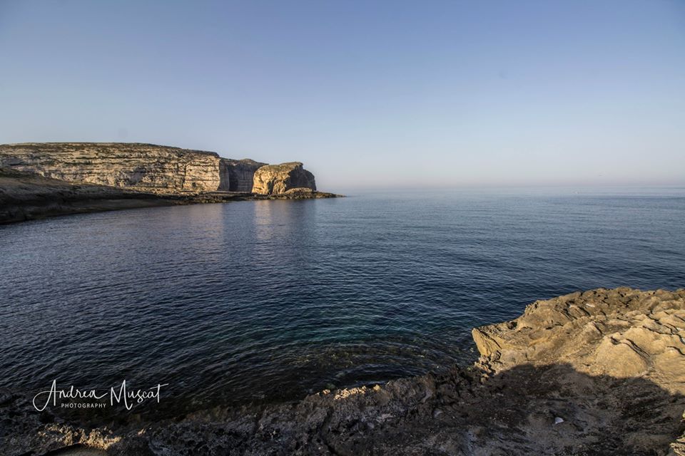
It goes without saying that summers in the Maltese Islands are always characterised by days of uninterrupted bright sunshine, hot temperatures and light winds. This is brought about by the intensification of the Azores High, which very often extends to cover all of the central Mediterranean. Like always, however, all seasons vary slightly from the climatic mean. Some summers are harsh, while others turn out to be a bit more forgiving.

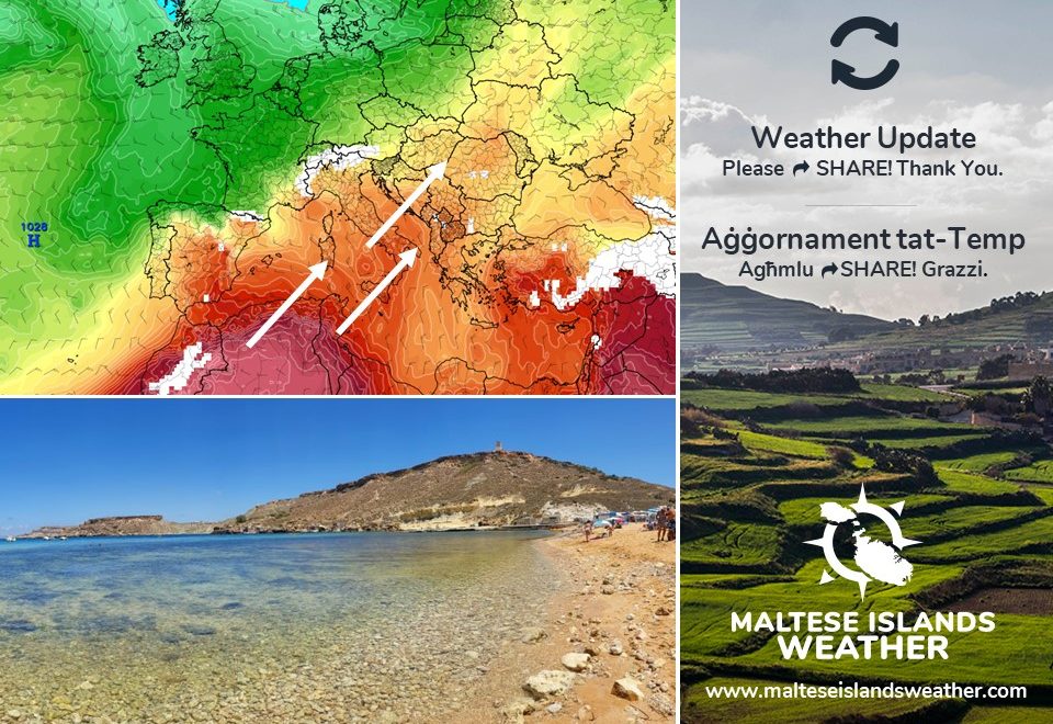
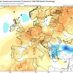
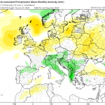
We’re in the early days of summer, and many are wondering what the weather situation will be like on the whole. Long-term maps suggest that summer 2020 will be close to average, or marginally hotter. Anticyclones over northern Europe are expected to be stronger and than normal. Meanwhile, atmospheric pressure across the Mediterranean will be slightly lower than average. This will prevent air masses of Arctic origin from reaching Europe. Conversely, this will allow air masses of Saharan origin to rise from north Africa into Europe more freely. This will lead to a hotter than average summer for much of Europe. The Maltese Islands will not be at the centre of this. While warmer-than-normal conditions may occur at times, temperatures will not be record-breaking. In fact, temperatures are likely to be consistent, hovering in the lower 30s. Locally, the only particular concern for a long-duration heat wave appears to exist for August. Overall, temperatures will likely be 0.25°C to 0.75°C above the climatic mean. Stronger anticyclones over northern Europe will mean that storms which normally affect the British Isles and Scandinavia will be pushed further south. Hence, the Maltese Islands may experience brief periods of strong winds at times. These are the highlights for this summer:

July 2020: Normal temperatures; Normal rainfall

August 2020: Normal temperatures; Normal rainfall

September 2020: Normal temperatures; Drier than average

Even if these long-term models turn out to be completely accurate, it does not mean that these predicted weather conditions will persist for three months straight. It only gives us an indication of how the weather pattern will be like most of the time.


Ma hemmx għalfejn ngħidu li s-sjuf ta’ Malta kull sena jkunu ddominati minn jiem sħaħ ta’ xemx tiżreġ, temperaturi sħan u riħ ħafif. Dan huwa r-riżultat ta’ l-‘Azores High’, li ta’ spiss testendi biex tgħatti ċ-ċentru tal-Mediterran. Bħal dejjem, pero’, l-istaġun kollha jvarjaw xi ftit mill-medja klimatika. Xi sjuf ikunu aktar ħorox minn oħrajn, u xi kultant ftit anqas qalila wkoll.

Ninsabu fl-ewwel jiem tas-sajf, u ħafna qed jaħsbu kif se tkun is-sitwazzjoni tat-temp fix-xhur li ġejjin. Il-mudelli tat-temp fit-tul qed jindikaw li sajf 2020 se jkun wieħed normali, jew xi ftit aktar sħun. L-antiċikluni lejn it-tramuntana ta’ l-Ewropa se jkunu aktar persistenti minn sena tipika. Sadattant, il-pressjoni ta’ l-arja madwar il-Mediterran se tkun daqsxejn anqas. Din se twaqqaf arja friska minn fuq l-Artiku minn li testendi lejn l-Ewropa b’mod frekwenti. Fl-istess waqt, arja sħuna minn fuq id-deżert se tkun tista tersaq il-fuq aktar. Din se twassal għal sajf aktar sħun minn normal madwar l-Ewropa. Il-Gżejjer Maltin mhux se jkunu fil-qalba ta’ dan. Filwaqt li xi jiem jistgħu jkunu ferm aktar sħan mill-medja, it-temperaturi mhux mistenni li jiksru rekords. Filfatt, it-temperaturi għandhom ikunu konsistenti fil-livelli baxxi ta’ fuq 30°C ħafna miż-żmien. Lokalment, l-uniku konċern għal mewġa ta’ sħana fit-tul se tkun lejn Awwissu. B’mod ġenerali, it-temperaturi probabilment jkunu xi 0.25°C sa 0.75°C ogħla mill-medja klimatika. Antiċikluni aktar b’saħħithom lejn in-naħar ta’ fuq ta’ l-Ewropa ifisser li sistemi ta’ maltemp li normalment jaħkmu l-Gżejjer Brittaniċi u l-Iskandinavja jistgħu jkunu mbuttati aktar l-isfel. Kaġun ta’ dan, il-Gżejjer Maltin se jesperjenzaw perjodi qosra ta’ riħ qawwi. Din hija ħarsa lejn kif jidher li se jkun is-sajf:

Lulju 2020: Temperaturi normali; Xita normali

Awwissu 2020: Temperaturi normali; Xita normali

Settembru 2020: Ftit aktar sħun minn normal; Aktar niexef minn normal

Anke jekk dawn il-mudelli fit-tul jirriżultaw li jkunu preċiżi għal aħħar, ma jfissirx li t-temp se jkun għal tlett xhur sħaħ. Jagħtuna biss ħjiel ta’ kif se jkun it-temp b’mod ġenerali matul is-sajf.
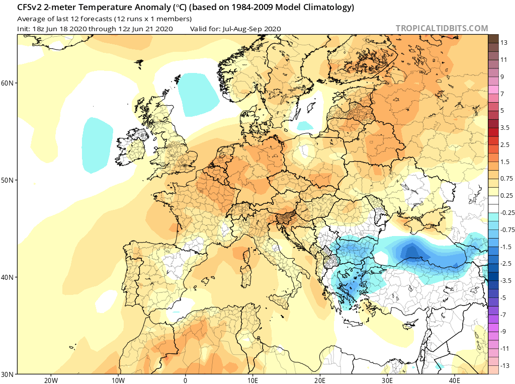
Updates

This week: Chance of rain at first, but very hot by the weekend

The instability that characterised our weather for much of last week will linger into the first half of this week. It will deepen somewhat too. An area of low pressure centred over the Balkans will direct cool air in the upper levels of the atmosphere towards the central Mediterranean. The warm air locally will clash with this, potentially triggering rain showers on Monday 22/06 and Tuesday 23/06. No severe weather is anticipated though. The Northwesterly wind is expected to decrease substantially on Monday, but is likely to still reach Force 5/6 at times. It will decrease more on Tuesday. A ridge of high pressure will extend from over north Africa to cover much of the central Mediterranean by midweek. This will stabilise the weather conditions over the Maltese Islands, heralding the start of a lengthy spell of light and variable winds. Days with long hours of uninterrupted bright sunshine will also resume from Wednesday. Air temperatures will be cooler than average to start with, with highs of 27°C. These are set to rise drastically in the second half of the week, soaring to 32°C / 33°C by the weekend. Real feels may be at a sweltering 36°C. Lows will be rising only marginally over the course of this week, from 20°C to 22°C.

Updates

Calmer days from Tuesday / Jiem aktar kalmi mit-Tlieta

As forecast, the wind has picked up. It will maintain its strength till Monday 22/06. It will reach Force 5/6 from the Northeast to Northwest on Saturday 20/06, Force 5/6 from the Northwest on Sunday 21/06 and Northwest Force 4/5 on Monday 22/06. This is the result of a trough of low pressure extending from the Balkans towards the central Mediterranean. An area of high pressure is expected to develop across our region by Tuesday 23/06. This means a more settled meteorological situation for the Maltese Islands. Tuesday 23/06 will herald the beginning of a lengthy spell of light winds. Air temperatures should then start rising over 30°C on a consistent basis by Friday 26/06.

Kif previst, ir-riħ qam sew. Dan se jżomm din il-qawwa sa nhar it-Tnejn 22/06. Se jilħaq Forza 5/6 mill-Grigal għal Majjistral is-Sibt 20/06, Forza 5/6 mill-Majjistral il-Ħadd 21/06 u Majjistral Forza 4/5 it-Tnejn 22/06. Dan huwa r-riżultat ta’ firxa ta’ pressjoni baxxa li qed testendi minn fuq il-Balkani lejn iċ-ċentru tal-Mediterran. Roqgħa ta’ arja bi pressjoni għolja imbagħad se tiżviluppa madwar ir-reġjun tagħna mit-Tlieta 23/06. Dan se jfisser sitwazzjoni ta’ temp aktar stabbli għal Gżejjer Maltin. Nhar it-Tlieta 23/06 mistenni li jkun il-bidu ta’ perjodu fit-tul ta’ riħ ħafif. It-temperatura imbagħad se tibda titla aktar minn 30°C b’mod aktar konsistenti minn nhar il-Ġimgħa 26/06.