Updates

For the latest updates related to the weather in the Maltese Islands. So keep yourself updated by visiting this page frequently or like our Facebook page.

Updates

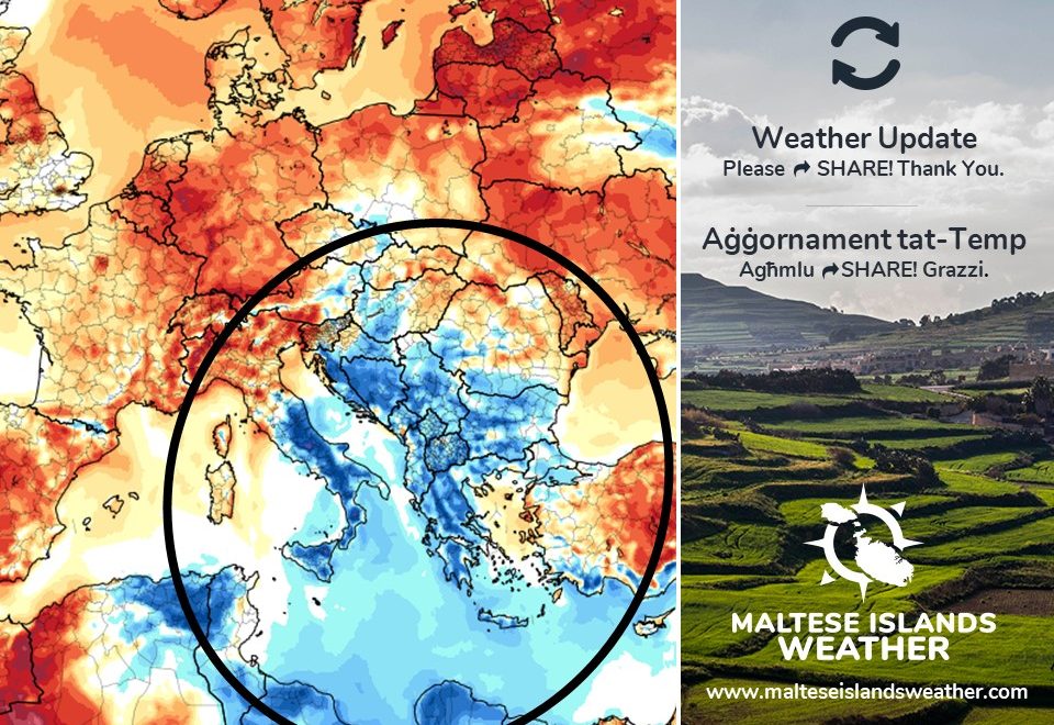
Slight instability for the start of summer / Instabbilita’ ħafifa għal bidu tas-sajf

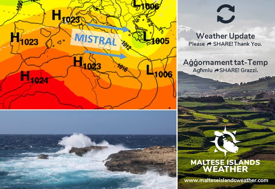
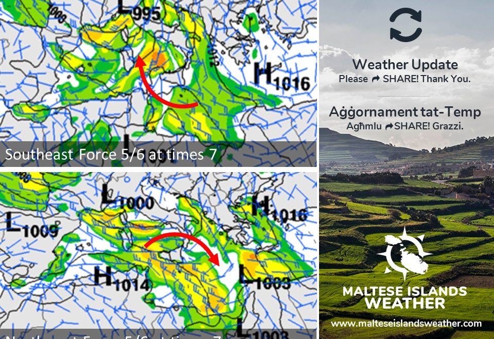
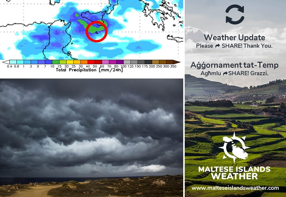
Thursday 18/06 and Friday 19/06 are two days with above-average temperatures, sunny skies and light winds. A slight instability will affect the Maltese Islands over the weekend and the first half of next week, however. The wind will strengthen. A strong wind (up to Force 5/6) from the East Southeast to East Northeast is expected late in the day on Friday 19/06 and all day Saturday 20/06. It will back Northwest and remain strong (up to Force 5/6) on Sunday 21/06. A lighter wind is anticipated for Monday 22/06. A light and variable wind, which will last all week, is expected from Tuesday 23/06 onward. Temperatures will once again dip to slightly below average. Highs will hover at 27°C / 28°C from Saturday 20/06 through to Thursday 25/06. Lows will be at a stable 20°C for the same time period. Values will soar to 30°C + again by the final weekend of June. Partly cloudy skies are likely on a day or two, especially Monday 22/06 and Tuesday 23/06. In fact, a little light rain is possible on Monday night.

Il-Ħamis 18/06 u l-Ġimgħa 19/06 huma jumejn b’temperaturi ta’ l-arja ogħla mill-medja, sema xemxi u riħ ħafif. Madankollu, instabbilita’ ħafifa se taffetwa l-Gżejjer Maltin fi tmiem il-ġimgħa u l-ewwel nofs tal-ġimgħa li ġejja. Ir-riħ se jitqawwa. Riħ qawwi (sa Forza 5/6) mix-Xlokk il-Lvant għal Grieg il-Lvant mistenni tard il-Ġimgħa 19/06 u matul il-jum kollu tas-Sibt 20/06. Dan se jdur Majjistral u jibqa qawwi (sa Forza 5/6) nhar il-Ħadd 21/06. Riħ aktar ħafif huwa mistenni għat-Tnejn 22/06. Riħ ħafif u varjabbli, li se jiddomina l-bqija tal-ġimgħa li ġejja, se jibda mit-Tlieta 23/06 ‘il quddiem. It-temperaturi wkoll se jerġgħu jinżlu taħt il-medja. L-ogħla se jkun fil-livell ta’ 27°C / 28°C mis-Sibt 20/06 sal-Ħamis 25/06. L-anqas se jkun stabbli fil-livell ta’ 20°C matul dan l-istess żmien. It-temperaturi għandhom jerġgħu jaqbżu t-30°C minn l-aħħar tmiem il-ġimgħa ta’ Ġunju. Sema ftit imsaħħab huwa possibbli f’xi jum jew tnejn, speċjalment nhar it-Tnejn 22/06 u t-Tlieta 23/06. Filfatt, xi ftit xita ħafifa hija possibbli wkoll matul il-lejl tat-Tnejn.

Updates

This week: Force 4/5 + winds on 5 of 7 days

After a taste of summer over the weekend, the atmosphere above the central Mediterranean will become unstable again. The Maltese Islands will find themselves sandwiched in between high pressure to the west and low pressure over the Aegean Sea and the Balkans. The high pressure to our west will prevent any cloud systems from reaching our area. This will maintain sunny or mainly sunny skies on most days. A sharp gradient between the two pressure areas will generate moderate to strong winds on most. In fact, some five of seven days this week will experience a wind of Force 4/5 or stronger. With the exception of Saturday 20/01, all days this week are to see a predominantly Northwest wind. Daytime highs will vary from a below average 25°C on Tuesday 16/06 to an around average 29°C over the weekend. Nighttime lows will be more uniform, at around 19°C / 20°C on all nights. Real feels will be far cooler on windy days. No rain is expected this week.

Updates

STRONG WIND WARNING / TWISSIJA TA’ RIĦ QAWWI

A low pressure system will develop over the Aegean Sea. Meanwhile, a ridge of high pressure that has covered the central Mediterranean over the past few days will retreat slightly westwards. This will create a pressure gradient across our region. A strong, cool northwesterly wind will affect the Maltese Islands as a result of this. The wind is expected to reach Force 5/6 with gusts of up to Force 7/8 at times. This wind warning is valid from midnight on Monday 15/06 till 03:00 on Wednesday 17/06. The details below describe how the situation is set to develop over this time period.


Monday 15/06

00:00 to 03:00 – Northwest Force 4/5 to 5/6

03:00 to 06:00 – Northwest Force 5/6

06:00 to 09:00 – Northwest Force 5/6 to 4/5

09:00 to 12:00 – Northwest Force 4/5 to 5/6

12:00 to 15:00 – Northwest Force 5/6

15:00 to 18:00 – Northwest Force 5/6 to 6/7

18:00 to 21:00 – Northwest Force 6/7 with gusts of up to Force 8

21:00 to 00:00 – Northwest Force 6/7 with gusts of up to Force 8

Tuesday 16/06

00:00 to 03:00 – Northwest Force 6/7 to 5/6

03:00 to 06:00 – Northwest Force 5/6 to 4/5

06:00 to 09:00 – Northwest Force 4/5 to 5/6

09:00 to 12:00 – Northwest Force 5/6

12:00 to 15:00 – Northwest Force 5/6 to 6/7

15:00 to 18:00 – Northwest Force 6/7 with gusts of up to Force 8

18:00 to 21:00 – Northwest Force 6/7 with gusts of up to Force 8

21:00 to 00:00 – Northwest Force 6/7 to 5/6

Wednesday 17/06

00:00 to 03:00 – Northwest Force 5/6 to 4/5


The peak gusts will blow across the Maltese Islands in the evening on Monday 15/06 and in the later afternoon on Tuesday 16/06, and may reach Force 8 across exposed areas. The wind should remain at Force 4/5 on Wednesday 17/06 and Thursday 18/06.

The sea will be rough, with wave heights of up to 4.5 metres in peak gusts. The swell will be a low Northwest. The map shows the length of coastline most exposed to this strong wind.


Sistema ta’ pressjoni baxxa se tiżviluppa fuq il-Baħar Eġew. Sadattant, firxa ta’ pressjoni għolja li għattiet li-ċentru tal-Mediterran fl-aħħar jiem se tersaq lejn il-punent. Din se twassal għal kuntrast qawwi fil-pressjoni atmosferika lokalment. Minħabba dan, riħ qawwi u frisk mill-Majjistral se jaffetwa l-Gżejjer Maltin. Din it-twissija tkun fis-seħħ minn nofsillejl tat-Tnejn 15/06 sa 03:00 ta’ l-Erbgħa 17/06. Id-dettalji ta’ hawn taħt juru kif mistennija tiżviluppa s-sitwazzjoni matul dan il-ħin.


It-Tnejn 15/06

00:00 sa 03:00 – Majjistral Forza 4/5 għal 5/6

03:00 sa 06:00 – Majjistral Forza 5/6

06:00 sa 09:00 – Majjistral Forza 5/6 għal 4/5

09:00 sa 12:00 – Majjistral Forza 4/5 għal 5/6

12:00 sa 15:00 – Majjistral Forza 5/6

15:00 sa 18:00 – Majjistral Forza 5/6 għal 6/7

18:00 sa 21:00 – Majjistral Forza 6/7 b’buffuri ta’ Forza 8

21:00 sa 00:00 – Majjistral Forza 6/7 b’buffuri ta’ Forza 8

It-Tlieta 16/06

00:00 sa 03:00 – Majjistral Forza 6/7 għal 5/6

03:00 sa 06:00 – Majjistral Forza 5/6 għal 4/5

06:00 sa 09:00 – Majjistral Forza 4/5 għal 5/6

09:00 sa 12:00 – Majjistral Forza 5/6

12:00 sa 15:00 – Majjistral Forza 5/6 għal 6/7

15:00 sa 18:00 – Majjistral Forza 6/7 b’buffuri ta’ Forza 8

18:00 sa 21:00 – Majjistral Forza 6/7 b’buffuri ta’ Forza 8

21:00 sa 00:00 – Majjistral Forza 6/7 għal 5/6

L-Erbgħa 17/06

00:00 sa 03:00 – Majjistral Force 5/6 għal 4/5


L-aktar buffuri qawwija se jonfħu it-Tnejn 15/06 filgħaxija u tard wara nofsinhar it-Tlieta 16/06, meta r-riħ jaf jilħaq Forza 8 f’inħawi esposti. Ir-riħ għandu jibqa Forza 4/5 l-Erbgħa 17/06 u l-Ħamis 18/06.

Ir-riħ se jkun qawwi, b’mewġ għoli 4.5 metri fl-aktar buffuri qawwijin. L-imbatt se jkun baxx Majjistral. Il-mappa turi l-inħawi tal-kosta l-aktar esposta għal dan ir-riħ qawwi.


Updates

Strong wind returns by late Sunday / Riħ qawwi jirritorna minn tard il-Ħadd

An area of high pressure over the central Mediterranean will ensure a weekend of bright sunshine and very warm temperatures (up to 29°C) across the Maltese Islands. This will change slightly by later in the day on Sunday 14/06. A low pressure system will develop over the Aegean Sea, whilst the high pressure covering our region will retreat slightly west. This setting will generate a strong wind from the Northwest locally. This should reach Force 6/7 from late in the afternoon on Sunday 14/06 till late in the evening on Tuesday 16/06. Reaching its peak on Monday, it could reach up to Force 8.

Roqgħa ta’ pressjoni baxxa fuq iċ-ċentru tal-Mediterran se tiżgura tmiem il-ġimgħa mill-isbaħ, b’ħafna xemx u arja sħuna (b’temperaturi sa 29°C) madwar il-Gżejjer Maltin. Din se tinbidel daqsxejn minn tard il-Ħadd 14/06, meta sistema’ ta’ pressjoni baxxa se tiżviluppa fuq il-Baħar Eġew. Fl-istess waqt, il-pressjoni għolja li tinsab fuq ir-reġjun tagħna se tersaq daqsxejn lejn il-punent. Dan se joħloq riħ qawwi mill-Majjistral lokalment. Dan għandu jilħaq il-Forza 6/7 minn tard wara nofsinhar tal-Ħadd 14/06 sa tard filgħaxija tat-Tlieta 16/06. Se jilħaq l-aqwa tiegħu nhar it-Tnejn, meta jista jonfoħ b’qawwa ta’ Forza 8.

Updates

This week: No ‘real’ summer weather just yet

Last week, June 2020 went off to an unseasonably cool start. With a mean temperature of 20.8°C, temperatures last week were almost a staggering 3°C cooler than normal. The first week of June 2020 ended up being the coolest first week of June on record! Temperatures will rise a bit this week. Highs will be in the range of 26°C to 28°C on all days this week, while lows will be of 19°C / 20°C on most nights. These daytime highs are still noticeably cooler than the values we are accustomed to at this time of year. The anticipated wind further confirms that the Maltese Islands will not enjoy any ‘real’ summer weather just yet. This comes as latest models reveal that a fresh Northwest breeze is set to characterise most days this week, keeping real-feel values in check. Skies will be partly to variably cloudy on most days. Although unlikely, a little rain is possible on a day or two. The unsettled weather will prevail since the Maltese Islands will continue to find themselves sandwiched in between low pressure to the north and high pressure to the south. This meteorological setting will ensure that cool air from over Europe will continue interacting with warm air from north Africa directly above the central Mediterranean.

Updates

A fresh breeze on most days / Żiffa friska kważi kuljum

Air temperatures will rise slightly from Sunday 07/06. Highs will be in the range of 26°C to 28°C on most days next week. Lows will be of around 19°C / 20°C on most nights. Despite this rise in temperatures, we will be nowhere close to the stifling heat of summer. A fresh Northwest breeze, which will be a notable characteristic of most days, should keep real-feel values in check. Another important factor which will help keep things fresh is the presence of partly to variably cloudy skies on most days. Although unlikely, a little rain can occur on a day or two. The unsettled weather will prevail since our islands will continue to find themselves sandwiched in between high and low pressure.

It-temperatura se togħla daqsxejn mill-Ħadd 07/06. L-ogħla se tvarja minn 26°C sa 28°C fil-biċċa l-kbira tal-jiem. L-anqas se tkun fil-medja ta’ 19°C / 20°C kuljum. Minkejja li t-temperaturi se jisħnu daqsxejn, xorta waħda se nkunu għadna ‘l bogħod minn dik is-sħana qalila tas-sajf. Żiffa friska mill-Majjistral, li se tikkaratteriżża ħafna mill-jiem li ġejjin, għandha żżomm it-temperaturi friski. Fattur importanti ieħor li se jkun qed jgħin iżomm it-temperaturi friski huwa sema ftit jew varjabbilment imsaħħab li se jiddomina l-jiem li ġejjin. Għalkemm mhux probabli, jaf ikollna xi ftit xita f’xi jiem. Dan it-temp instabbli huwa minħabba l-fatt li l-Gżejjer Maltin se jkomplu jsibu ruħhom maqbudin bejn rqajja ta’ pressjoni għolja u firxiet ta’ pressjoni baxxa.

Updates

3 Hourly Forecast for Sette Guigno (07/06/2020)

00:00 to 03:00 – mainly clear or partly cloudy; 20°C to 19°C; Northwest Force 3/4 to 2/3
03:00 to 06:00 – mainly clear or partly cloudy; 19°C; Northwest Force 2/3 to 1/2
06:00 to 09:00 – mainly clear or partly cloudy; 19°C to 23°C; Northwest to Southwest Force 1/2 to 2/3
09:00 to 12:00 – mainly clear or partly cloudy; 23°C to 25°C; Southwest Force 2/3
12:00 to 15:00 – mainly clear or partly cloudy; 25°C to 27°C; Southwest to South Force 2/3 to 3/4
15:00 to 18:00 – mainly clear or partly cloudy; 27°C to 24°C; South Force 3/4
18:00 to 21:00 – mainly clear or partly cloudy; 24°C to 22°C; South to Southeast Force 3/4
21:00 to 00:00 – mainly clear or partly cloudy; 22°C to 21°C; Southeast Force 3/4 to 4/5

Sette Guigno is a Maltese national holiday celebrated annually on June 7. In the aftermath of World War I, with the widespread disruptions in agriculture and industry across the whole of the European continent, the Maltese colonial government failed to provide an adequate supply of basic food provisions for the island. In response to this, there were a series of riots in the Maltese Islands. On that day in 1919 when, following one of the riots by the Maltese population, British troops fired into the crowd, killing four.

Updates

Wind to strengthen again / Ir-riħ se jerġa jitqawwa

The wind is set to be quite strong over the next three days or so. A low pressure system will develop over the Gulf of Genoa on Thursday 04/06. This will draw in air from high pressure over Libya. Consequently, a Force 5/6 at times 7 wind from the Southeast will blow across the central Mediterranean from late in the afternoon on Thursday 04/06 till early in the morning on Friday 05/06. A brief interval of calm will follow. Do not let this fool you though. An area of high pressure will form to our west early on Friday 05/06. Simultaneously, a trough of low pressure will develop over Libya. The wind will shift to the Northwest before increasing again. It will reach Force 5/6 at times 7 across the central Mediterranean from early in the afternoon on Friday 05/06 till late in the afternoon on Saturday 06/06. A light and variable wind returns to the Maltese Islands on Sunday 07/06. Airborne fine desert sand could accompany the strong Southeast wind.

Ir-riħ għandu jitqawwa matul it-tlett ijiem li ġejjin. Sistema ta’ pressjoni baxxa se tiżviluppa fuq il-Golf ta’ Genoa l-Ħamis 04/06. Din se tiġbed arja minn roqgħa ta’ pressjoni għolja fuq il-Libja. Kawża ta’ dan, riħ Forza 5/6 kultant 7 mix-Xlokk se jaffetwa iċ-ċentru tal-Mediterran minn tard wara nofsinhar tal-Ħamis 04/06 sa kmieni filgħodu tal-Ġimgħa 05/06. Waqfa qasira ta’ kalma se ssegwi. Tħallux din tqarraq bikom. Roqgħa ta’ pressjoni għolja mistennija tifforma lejn il-punent tagħna kmieni l-Ġimgħa 05/06. Fl-istess waqt, firxa ta’ pressjoni baxxa se tinħoloq fuq il-Libja. Ir-riħ idur Majjistral qabel ma jerġa jżid. Dan se jilħaq Forza 5/6 kultant 7 madwar iċ-ċentru tal-Mediterran minn kmieni wara nofsinhar tal-Ġimgħa 05/06 sa tard wara nofsinhar tas-Sibt 06/06. Riħ ħafif u varjabbli jerġa jasal fuq il-Gżejjer Maltin mill-Ħadd 07/06. Trab fin fl-arja jista jkun assoċjat mar-riħ qawwi mix-Xlokk.

Updates

This week: Getting warmer

The central Mediterranean will continue to be caught up in between two areas of different atmospheric pressure. An advection of warm and moist air to our west, heading from north Africa towards Europe to our west, will prevail and shift progressively eastwards in the coming days. A stream of cold and dry air to our east, flowing from Europe towards north Africa, is expected to diminish over the course of this week. The area of warm and moist air is set to cover our whole area by the weekend. The first days of the week will be particularly volatile, with sunny to mainly sunny skies possibly giving way to afternoon clouds due to diurnal heating and light winds. Localised showers may not be ruled out as well. The presence of warm and moist air blown across our region by mainly southerly winds may generate grey skies over the second half of this week. Air temperatures will increase gradually. Highs will rise from 25°C to 30°C. Lows will also become warmer, rising from 17°C to 22°C. Winds will be light and variable till Thursday 04/06, before turning southeast and strengthening by the weekend. There will be no airborne fine desert sand.

Updates

Possible thunderstorms / Maltempati bir-ragħad possibli

The atmosphere above the Maltese Islands has been greatly unstable for much of this week. To our west, warm and moist air is rising towards Europe from north Africa. To our east, cold and dry air is descending towards north Africa from Europe. Our region has found itself caught in between this. As a result, relatively cold air is constantly being brought over a warm central Mediterranean. This is creating a great deal of instability. The difference between the two will be more pronounced again on Saturday 30/05, leading to the formation of an upper-level low pressure system over our area. This will be strongest in the late afternoon across the stretch of sea between the Maltese Islands and Sicily. Colder air in the upper levels of the atmosphere increases instability. This is because the warmer air at ground level, being lighter and more buoyant, tends to rise. This vertical movement cools the rising air, causing the moisture within to condense and form clouds. The day will start off with mainly fine weather. This will change rapidly, however, with clouds building up as the day progresses. These are expected to develop showers and isolated thunderstorms by the afternoon. Most showers will remain out at sea, but some will move inland. Any showers may be heavy, thundery and/or with hail at times. The wind will increase ahead of and during any showers. Waterspouts are also likely to form at sea. Rainfall amounts should vary considerably, with some areas possibly remaining completely dry. The chance of rain will be highest from noon till midnight.

L-atmosfera fuq il-Gżejjer Maltin ilha instabbli għal dawn l-aħħar jiem. Lejn il-punent tagħna nsibu arja sħuna u umda tiela minn fuq l-Afrika lejn l-Ewropa. Lejn il-lvant tagħna hemm arja kiesħa u niexfa nieżla minn fuq l-Ewropa lejn l-Afrika. Ir-reġjun tagħna jinsab maqbud sewwa sew bejniethom. Minħabba f’hekk, arja kiesħa qqed tiġi mbuttata fuq roqgħa sħuna fiċ-ċentru tal-Mediterran. Din qed twassal għal instabbilita’ kbira. Id-differenza bejn dawn it-tnejn se terġa tkun kbira nhar is-Sibt 30/05, u b’hekk se tiżviluppa sistema ta’ pressjoni baxxa fil-livelli għoljin ta’ l-atmosfera fuqna. Din se tkun l-aktar b’saħħitha tard wara nofsinhar fuq il-firxa ta’ baħar bejn il-Gżejjer Maltin u Sqallija. Arja kiesħa fil-livelli għoljin ta’ l-atmosfera twassal għal instabbilita’. Dan minħabba t-tendenza li arja sħuna, peress li hija eħfef, titla ‘l fuq. Din l-arja tiela tiksaħ u l-fwar li tkun qed iġġorr jikkondensa fi sħab. Il-ġurnata se tibda b’temp sabiħ li jinbidel f’maltemp f’ħin qasir, bl-ammont ta’ sħab jiżdied mal-ħin. Dan se jiżviluppa f’ħalbiet tax-xita u maltempati bir-ragħad iżolati minn wara nofsinhar. Ix-xita se tibqa l-biċċa l-kbira fuq il-baħar. Xi wħud se jmissu l-art, pero’. Ix-xita tista tkun qawwija, bir-ragħad u/jew bis-silġ f’xi ħinijiet. Ir-riħ jiżdied qabel u waqt ħalbiet tax-xita. Hemm probabilita kbira li jiffurmaw trombi fuq il-baħar ukoll. L-ammont ta’ xita mistenni li jvarja ħafna, b’xi nħawi possibilment jibqgħu niexfa għal kollox. Iċ-ċans ta’ xita se jkun l-ogħla minn nofsinhar sa nofsillejl.