Updates

For the latest updates related to the weather in the Maltese Islands. So keep yourself updated by visiting this page frequently or like our Facebook page.

Updates

Possible showers / Possibilita’ ta’ ħalbiet tax-xita

The weather forecast for Wednesday 27/05 has changed quite a bit. As expected, an inflow of cold air in the upper levels of the atmosphere has reached the central Mediterranean. This is stronger than initially predicted, however. Colder air in the upper levels of the atmosphere increases instability. This is because colder air aloft encourages the warmer air at ground level to rise. This vertical movement leads to the condensation of water vapour and thus the formation of clouds. On days with light winds, like this week, this upward movement of air is uninterrupted. As a result, clouds could are able to reach more substantial sizes. In this case, rain may occur. In fact, shower will likely occur in places on Wednesday 27/05. The rain will not deposit fine desert sand either. These clouds often dissipate by evening, as energy received from the sun dwindles.

It-tbassir tat-temp għal Erbgħa 27/05 imbidel ftit mhux hażin. Kif mistenni, massa ta’ arja kiesħa fil-livelli għoljin ta’ l-atmosfera laħqet iċ-ċentru tal-Mediterran. Din hija aktar b’saħħitha minn kemm kien mistenni, pero’. Arja kiesħa fil-livelli għoljin ta’ l-atmosfera toħloq instabbilita’. Dan minħabba li arja friska fil-għoli twassal biex arja sħuna qrib l-art tibda tiela ‘l fuq. Dan il-moviment vertikali ta’ arja jwassal għal kondensazzjoni ta’ fwar u konsegwenza ta’ dan, il-formazzjoni ta’ sħab. F’jiem b’riħ ħafif, bħal din il-ġimgħa, l-arja titla ‘l fuq fl-atmosfera bla interuzzjoni. Riżultat ta’ dan, is-sħab jista jilħaq daqs sostanzjali. F’dan il-każ, tista tagħmel ix-xita. Filfatt, teżisti l-possibilita’ ta’ xi ħalba jew tnejn xita. Ix-xita mhux se tkun tal-ħamrija. Sħab ta’ dan it-tip normalment jisfaxxa fix-xejn sa filgħaxija, hekk kif is-sħana li jkun irċieva mix-xemx tintilef.

Updates

This week: Stability will prevail

High pressure re-strengthened across the central Mediterranean over the weekend. This high pressure will prevail throughout this week. The weather will be sunny or mainly sunny on all days. There will be early and late mist or fog patches on some days too polska-ed.com. This could be accompanied by a heavy dewfall. The wind will be light on all days. It will start off calm till dawn, before strengthening to Force 3/4 during the day, and eventually dying down in the evening. Wind direction will vary from day to day. Temperatures will not be exceptionally warm, though. Highs will range from 24°C to 26°C, while lows will be at the level of 16°C / 17°C. This stability in air temperatures is due to an influx of cool air from over eastern Europe. No rain is expected this week. There will be no airborne fine desert sand either.

Updates

Wind to die down / Ir-riħ se jikkalma

An area of low pressure over the Balkans will dissolve. Meanwhile, a ridge of high pressure will extend across the central Mediterranean. As a result, the weather in the Maltese Islands will stabilise. The strong Northwest wind which has swept our islands in recent days will die down. From Friday 22/05 onward, most days will be seeing a light and variable wind. The sky will be sunny or mainly sunny on most days. Temperatures will be warmer too. Highs will vary from 26°C to 28°C, whilst lows will settle at 17°C / 18°C. Most days will be characterised by early and/or late mist or fog patches. There will be no airborne fine desert sand.

Roqgħa ta’ pressjoni baxxa fuq il-Balkani se tisfaxxa. Sadattant, firxa ta’ pressjoni għolja se testendi madwar iċ-ċentru tal-Mediterran. Riżultat ta’ dan, it-temp fil-Gżejjer Maltin se jistabiliżża. Riħ qawwi mill-Majjistral li dan l-aħħar ħakem gżiritna se jieqaf. Mill-Ġimgħa 22/05 ‘il quddiem, ħafna jiem se jkunu b’riħ ħafif u varju. Is-sema mistenni jkun xemxi jew il-biċċa l-kbira xemxi kważi kuljum. It-temperaturi se jisħnu wkoll. L-ogħla tibda tvarja minn 26°C sa 28°C, filwaqt li l-anqas se tibda tkun ta’ 17°C / 18°C. Se naraw ukoll irqajja ta’ ċpar kmieni u tard f’ħafna jiem. Mhux se jkun hemm trab fin fl-arja.

Updates

Mistral to clear away the airborne dust / Majjistral se jnaddaf l-arja mit-trab

A low pressure system over Sardinia will migrate slowly towards the Balkans. Its effects will be felt locally for some 72 hours, from Tuesday 19/05 through to Thursday 21/05. The wind will be from the Northwest, reaching Force 5/6 with gusts of up to Force 7 at times. It will be strongest on Wednesday. The Northwest wind will clear away the fine desert sand which continues to choke our atmosphere. The low pressure system will drag with it cooler air from over Europe. This will cause air temperatures to dip, with 23°C / 24°C highs and 17°C / 18°C lows on all three days. The sky will be mainly sunny or partly cloudy much of the time. Although highly unlikely, a stray isolated shower might occur. This would be brief, light and very localised. Fine weather with warm temperatures and light winds will return by Friday 22/05.

Sistema ta’ pressjoni baxxa fuq Sardenja se tersaq bilmod lejn il-Balkani. L-effetti tagħha se jinħassu lokalment għal xi 72 siegħa, mit-Tlieta 19/05 sal-Ħamis 21/05. Ir-riħ ikun mill-Majjistral, u previst li jilħaq Forza 5/6 b’buffuri ta’ Forza 7 kultant. Se jkun l-aktar qawwi l-Erbgħa. Dan ir-riħ mill-Majjistral se jnaddaf l-arja ta’ madwarna mit-trab li ddomina l-ajru dan l-aħħar. L-istess pressjoni baxxa se ġġib magħha massa ta’ arja friska minn fuq l-Ewropa. Dan mistenni jbaxxi t-temperaturi matul dawn it-tlett ijiem li ġejjin, bl-ogħla tilħaq biss 23°C / 24°C u l-anqas tinżel għal 17°C / 18°C. Is-sema se jkun il-biċċa l-kbira xemxi jew ftit imsaħħab ħafna mill-ħin. Għalkemm żgħir ħafna, jeżisti ċans ta’ xi ħalba xita iżolata. Jekk isseħħ din tkun qasira, ħafifa u lokaliżżata ħafna. Temp bnazzi b’temperaturi sħan u riħ ħafif jirritorna mill-Ġimgħa 22/05.

Updates

This week: Temperatures to cool down briefly

A plume of hot air from north Africa covered much of the central and eastern Mediterranean over the past couple of days. This gave rise to the first heatwave of 2020, with temperatures soaring to 34°C in places. The coming week is expected to be somewhat different. An extensive low pressure system currently over the western Mediterranean will migrate slowly eastwards, towards the Balkans. The southern edge of this system will affect us for most of the week. This low pressure system will drag cooler air from Europe towards our region, causing air temperatures to dip quite a bit. Maximum temperatures will decrease from Monday 18/05, and dip to 24°C for three days around midweek. A strong Northeast wind on Monday will give way to a strong West Northwest breeze. This too will last for some three days around midweek. Another impact this low pressure system will have on the Maltese Islands is increased cloud cover. A slight chance of a stray shower exists for Wednesday 20/05. A very positive thing to note is that the turning wind will clear away all airborne fine desert sand by Tuesday 19/05. The weekend, on the other hand, should see the re-strengthening of high pressure across the central Mediterranean. Starting on Friday 22/05, we will have hours of uninterrupted bright sunshine, calmer winds and warmer temperatures (26°C / 27°C highs). With the exception of Monday 18/05, minimum temperatures are set to be at a more comfortable 17°C / 18°C on all nights.

Updates

First heatwave of 2020 at the door / L-ewwel ‘heatwave’ ta’ l-2020 wara l-bieb

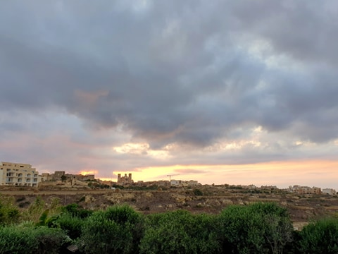
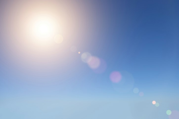
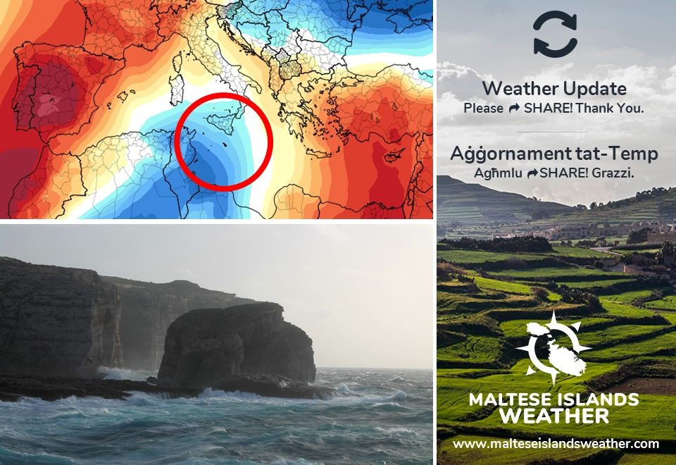
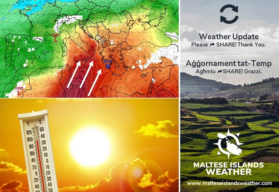
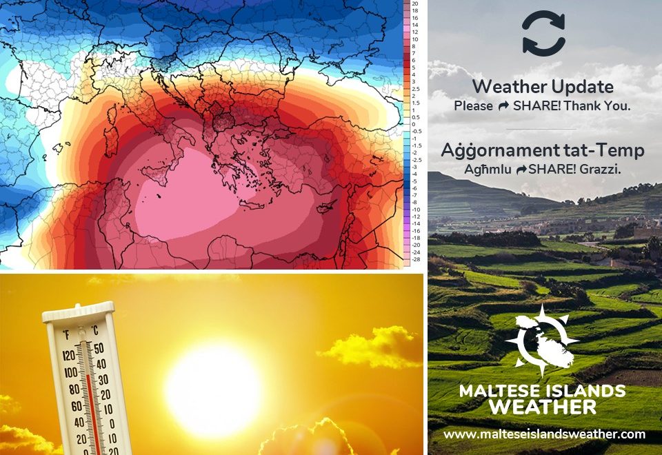
An area of high pressure emerging from north Africa will drag with it a plume of hot air over the central and eastern Mediterranean. From Thursday 14/05 through to Sunday 17/05, the Maltese Islands will experience daytime highs in the region of 30°C to 34°C. These values are 7°C to 11°C higher than the mean maximum temperature for May. As a result, it will qualify as a heatwave. The relatively high humidity will push real-feel values up. They will reach 36°C at times early in the afternoon. Nights should be clammy. These real-feel values can lead to certain dangerous heat disorders with prolonged exposure and/or physical activity. These include heat cramps, heat exhaustion and heat stroke. The UV Index will be at 11+ on some days. This means an extreme risk of harm from unprotected sun exposure. It is best to take all precautions because unprotected skin and eyes can be damaged. UV is highest early in the afternoon. The sky will be white in colour when not covered in clouds, due to airborne fine desert sand. The wind will be mainly East Southeast, blowing very strong at times, mainly on Thursday 14/05, Saturday 16/05 and Sunday 17/05.

Follow these precautions to minimise the risk of any of the hazards mentioned earlier on. Precautions include:

  • Shut windows and pull down shades when hotter outside. Open again when cool.
  • Avoid direct exposure to the sun between 11am and 4pm.
  • Have cool baths or showers.
  • Drink cool drinks, such as water or juice, regularly. Avoid tea, coffee and alcohol.
  • Wear SPF 30+ sunscreen and sunglasses.
  • Watch out for bright surfaces, like sand and water. These increase UV exposure.
  • Keep all pets and possibly stray animals in a cool area.
  • Do not take pets out for walks in the sun (you may have shoes to protect your feet but their paws are in contact with the hot ground).
  • Never leave anyone (including animals) in closed vehicles.
  • Be more careful with materials conducive to fires (such as BBQs, cigarettes, glass disposal, garden litter etc …)

The African plume will retreat slowly on Monday 18/05. A strong Northwest wind will cause air temperatures to dip to average levels by Tuesday 19/05.


Firxa ta’ pressjoni għolja li se tfeġġ minn l-Afrika ta’ fuq se tkun qed tgħatti iċ-ċentru u l-lvant tal-Mediterran. Mill-Ħamis 14/05 sal-Ħadd 17/05, il-Gżejjer Maltin se jesperjenzaw temperaturi massimi ta’ 30°C sa 34°C. Dawn huma xi 7°C sa 11°C ogħla mill-medja għal dan iż-żmien tas-sena. Għalhekk, dan il-perjodu ta’ sħan se jikkwalifika bħala ‘heatwave’. Il-livelli ta’ l-umdita’ se jfissru li dawn it-temperaturi jinħassu aktar sħan. Filfatt, se jkunu qed jinħassu daqs li kieku 36°C f’xi ħin kmieni wara nofsinhar. L-iljieli jkunu umdi. Temperaturi bħal dawn jistgħu iwasslu għal xi kundizzjonijiet assoċjati ma’ sħana qawwija f’każ li wieħed jesponi ruħu fit-tul jew jagħmel attivita’ fiżika eċċessiva f’din is-sħana. Dawn jinkludu ‘heat cramps’, ‘heat exhaustion’ u ‘heat stroke’. L-indiċi UV se tkun f’livell estrem ta’ 11+ f’xi jiem. Dan ifisser riskju estrem ta’ ħsara mix-xemx. Jeħtieġ li nieħdu kull prekawzzjoni peress li l-ġilda u għajnejn mhux protetti jistgħu isofru ħsara. Il-UV tkun l-ogħla kmieni wara nofsinhar. Is-sema se jkun abjad meta ma jkunx mgħotti bis-sħab, minħabba trab fin mid-deżert fl-arja. Ir-riħ se jkun il-biċċa l-kbira mix-Xlokk il-Lvant, u se jkun qawwi kultant, l-aktar nhar il-Ħamis 14/05, is-Sibt 16/05 u l-Ħadd 17/05.

Segwu dawn il-messaġġi ta’ prekawzjonijiet biex tnaqqsu r-riskju tal-perikli mis-sħana:

  • Agħlqu t-twieqi u l-blinds/shutters fl-eqqel tas-sħana. Erġgħu iftħu x’ħin jiffriska.
  • Evitaw li toqgħodu fix-xemx bejn 11am u 4pm.
  • Inħaslu b’ilma frisk.
  • Ixorbu xarbiet friski ta’ spiss. Pruvaw evitaw te’, kafe’ u alkoħol.
  • Użaw SPF 30% sunscreen u nuċċali tax-xemx.
  • Oqgħodu attenti minn uċuħ ċari bħal ilma u r-ramel. Dawn iżidu l-effett tal-UV.
  • Żommu l-annimali tagħkom u anke dawk tat-triq jekk possibbli f’post frisk.
  • Toħorġux lil klieb jimxu fix-xemx (aħna għandna żarbun jipproteġina mil-art tikwi, l-annimali ma għandhomx).
  • Qatt tħalli lil ħadd, inkluż annimali, f’vetturi.
  • Użaw materjali fjammabbli b’aktar reqqa (bħal BBQs, sigaretti, ħġieġ, kimiċi tal-pool, skart organiku etc …).

Din il-vampa Afrikana se tħallina bilmod nhar it-Tnejn 18/05. Riħ qawwi mill-Majjistral iniżżel it-temperaturi għal livelli medji minn nhar it-Tlieta 19/05.

Updates

This week: First heatwave of the year likely

The weak area of low pressure covering the central Mediterranean on Sunday 10/05 will fade away rapidly into the start of this week. A high pressure system will take hold of our region by Monday 11/05, strengthening quickly as the week progresses. Meanwhile, a deep low pressure system will take hold of western Europe. This setting will perfect for the generation of a hot wind from the South. With the exception of Monday 11/05 and Tuesday 12/05, the wind’s expected to blow from the South on all days. It will be moderate to strong on some days. In terms of temperatures, we’re expecting this week to be much warmer. Although still not 100% confirmed, they are likely to be sizzling hot by Thursday 14/05. Values for maximum temperatures will range from 25°C to 32°C. Minimum temperatures, on the other hand, will vary from 17°C to 24°C. In the event of a heatwave, daytime highs may soar to 35°C on Friday 13/04 and Saturday 14/05. We will update you accordingly as the week progresses. Although some days will be cloudy or hazy (due to airborne fine desert sand), no rain is expected.


Updates

Probable heatwave in a week’s time / Probabilita ta’ mewġa ta’ sħana ġimgħa oħra

Maximum temperatures are currently at or slightly below the average for this time of year. Things will change next week, however. The Sahara Desert high pressure system will extend across the central Mediterranean. This will drag very hot air from over north Africa. From Monday 11/05 onward, temperatures will rise substantially. We may in fact experience a heatwave. By Malta’s definition, a heatwave is a spell of three or more consecutive days with daytime highs exceeding the mean maximum temperature for that particular time of year by 5°C or more. We may see this happen from Thursday 14/05 through to Saturday 16/05. Maximum temperatures on all three days will most likely exceed 30°C, with less conservative models predicting the possibility of a sweltering 35°C. The wind on these three days is anticipated to be very strong from the South. The UV Index will be at Level 10, which means a very high risk of harm from unprotected sun exposure. UV is highest in the early afternoon.

It-temperaturi massimi bħalissa jinsabu bejn wieħed u ieħor mal-medja għal dan iż-żmien tas-sena. Is-sitwazzjoni se tinbidel il-ġimgħa li ġejja, pero’. Sistema ta’ pressjoni baxxa fuq id-deżert tas-Sahara se testendi lejn iċ-ċentru tal-Mediterran. Din se ġġib magħha arja taħraq ħafna minn l-Afrika ta’ fuq. Minn nhar it-Tnejn 11/05 ‘il quddiem, it-temperaturi se jkunu qed jogħlew sew. F’Malta, ‘heatwave’ hija deskritta bħala perjodu b’minn ta’ l-anqas tlett ijiem konsekkuttivi fejn l-ogħla temperatura taqbeż il-medja għal dak iż-żmien tas-sena b’5°C jew aktar. Filfatt, nistgħu naraw dan iseħħ minn nhar il-Ħamis 14/05 sas-Sibt 16/05. L-ogħla temperatura matul dawn it-tlett ijiem probabli taqbeż it-30°C, u b’xi mudelli anqas konservattivi jindikaw il-possibilita li din tilħaq 35°C. Ir-riħ f’dawk il-jiem ser ikun qawwi ħafna minn Nofsinhar. L-Indiċi Ultravjola se tilħaq Livell 10. Dan ifisser riskju għoli ħafna ta’ ħsara minn esponiment mhux protett għax-xemx. Din tkun l-agħar kmieni wara nofsinhar.

Updates

This week: The wind turns South

An area of high pressure over the central Mediterranean will prevail for much of this week, bringing many days of bright sunshine with some high cloud at times. An area of low pressure from over north Africa will bring a cloudier sky over the weekend. No rain is expected though. Dense fog and heavy dewfall is possible on Tuesday 05/05 and Wednesday 06/05. The strong Northwest that has characterised our weather these past few days will die down and veer East to Southeast. It will remain so for much of this week. Winds will be light on most days, but should be strong to very strong on Thursday 07/05 and Sunday 10/05, however. We expect 23°C / 24°C highs and 16°C / 17°C lows throughout the week. Wednesday 06/05 will be the only exception. The maximum temperature may soar to 30°C on that day. This will be followed by a very warm night (20°C low) polska-ed.com.

Updates

3 Hourly Forecast for Workers’ Day (01/05/2020)

00:00 to 03:00 -mainly clear; 17°C to 16°C; West Northwest Force 4/5
03:00 to 06:00 – mainly clear; 16°C to 15°C; West Northwest Force 4/5
06:00 to 09:00 – mainly clear; 15°C to 18°C; West Northwest Force 4/5
09:00 to 12:00 – mainly clear; 18°C to 21°C; West Northwest Force 4/5
12:00 to 15:00 – mainly clear; 21°C to 23°C; West Northwest Force 4/5 to 5/6
15:00 to 18:00 – mainly clear; 23°C to 21°C; West Northwest Force 5/6
18:00 to 21:00 – mainly clear; 21°C to 18°C; West Northwest Force 5/6
21:00 to 00:00 – mainly clear; 18°C to 17°C; West Northwest Force 5/6

Worker’s Day (or Labour Day) is an annual holiday celebrated all over the world, recognising the economic and social achievements of workers. Popularly known as May Day or International Workers’ Day, the 1st of May is also a public holiday in Malta and Gozo. It also marks the legal establishment of the eight-hour working day. The date also coincides with the religious feast of St. Joseph the Worker celebrated in the town of B’Kara. It is also 16 years since Malta joined the European Union.