Updates

For the latest updates related to the weather in the Maltese Islands. So keep yourself updated by visiting this page frequently or like our Facebook page.

Updates

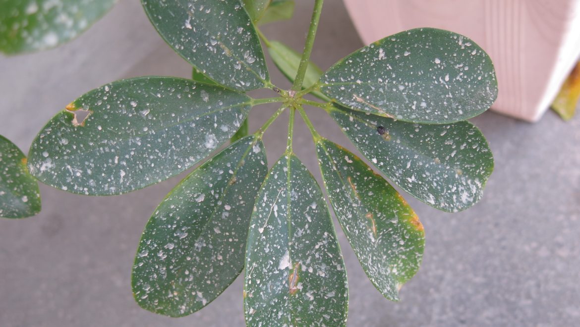
The cleaning go-ahead / Il-‘go-ahead’ biex tnaddfu

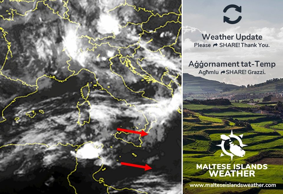
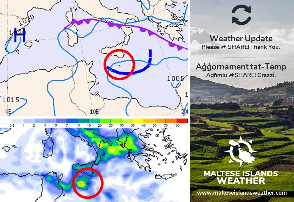
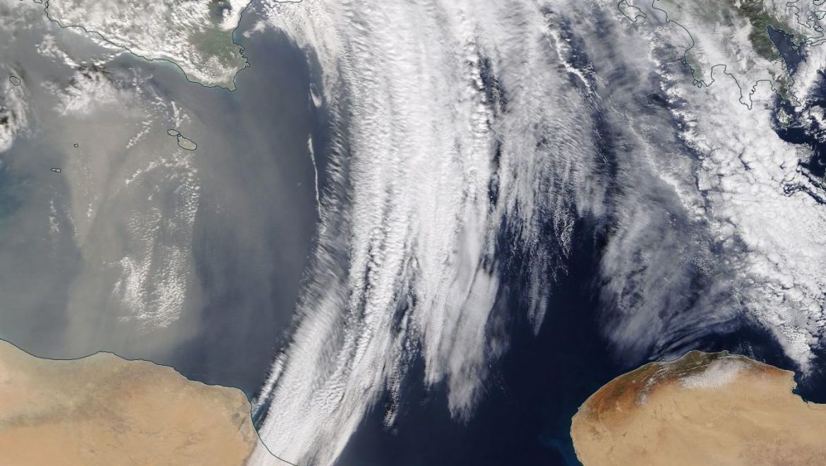
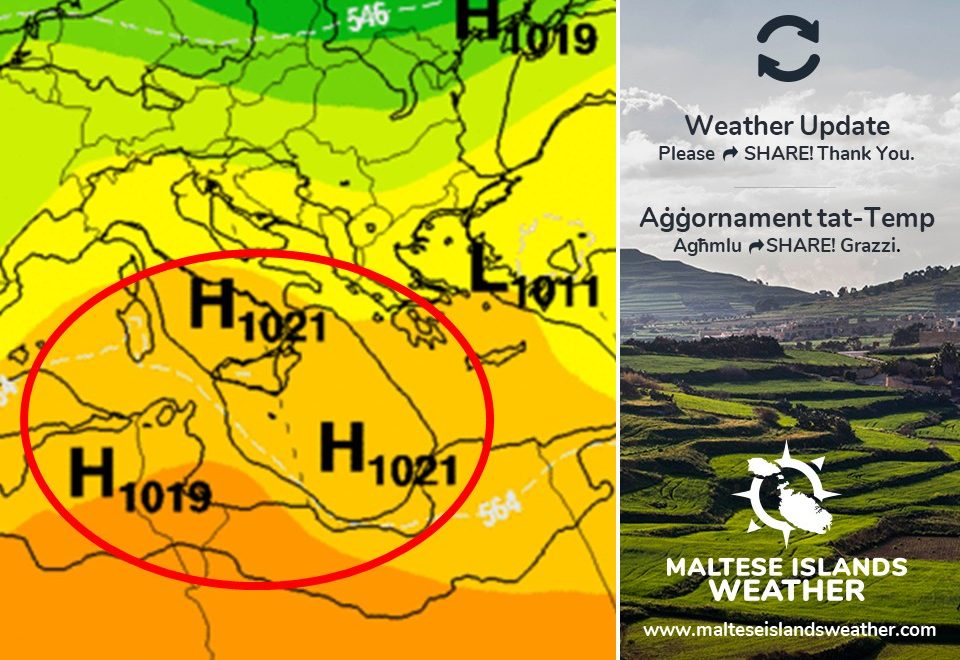
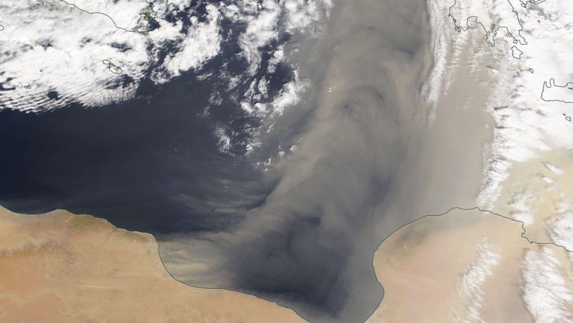
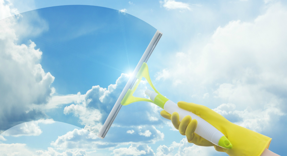
The past few weeks have brought with them a number of days with blood rain. Finally, the latest long-term maps have continued to confirm what we were expecting. An area of high pressure will cover the central Mediterranean. This should ensure a lengthy dry spell that will last into the foreseeable future. Long days of uninterrupted bright sunshine lie ahead. The wind till late on Sunday 03/05 will be a strong Northwest. This will die down next week. A gradual rise in temperatures is also anticipated. Highs may touch the 30°C mark for the first time this year by mid-May. We are confident in this forecast, and are therefore assuring you that any cleaning done today should last for some time.

Dawn l-aħħar ftit ġimgħat ġabu magħhom jiem ta’ xita tal-ħamrija. Sa fl-aħħar, il-mapep fit-tul qed jikkonfermaw dak li konna qed nistennew. Roqgħa ta’ arja bi pressjoni għolja se tinfirex madwar iċ-ċentru tal-Mediterran. Din se tiżgura perjodu ta’ nixfa fit-tul. Għandna quddiemna jiem twal ta’ xemx. Ir-riħ sa tard nhar il-Ħadd 03/05 se jkun qawwi mill-Majjistral. Dan jikkalma l-ġimgħa li ġejja. It-temperaturi se jibdew telgħin ukoll. Filfatt, dawk massimi jafu jilħqu l-livell ta’ 30°C għal-ewwel darba din is-sena lejn nofs Mejju. Aħna ninsabu kunfidenti f’dan it-tbassir, u għalhekk nistgħu ngħidulkom li kull tindif li jsir illum għandu jservi fit-tul.

Updates

A few drops of blood rain / Ftit taqtiriet tal-ħamrija

A trough of low pressure over Tunisia will move across the central Mediterranean on Wednesday 29/04. There are thunderstorms over Tunisia this evening. These will disintegrate completely on their way. The weather across the Maltese Islands on Wednesday will be variably to mostly cloudy due to high cloud. A few drops of blood rain could occur too, particularly later in the day. The wind will be light and variable, becoming North Force 4/5 by the early afternoon. The go-ahead for cleaning cars and windows should be given early on Thursday 30/04, when a lengthy spell of dry weather is expected to start!

Front ta’ pressjoni fuq it-Tuneżija se jgħaddi minn fuq iċ-ċentru tal-Mediterran nhar l-ERbgħa 29/04. Bħalissa qed nosservaw maltempati bir-ragħad fuq Tuneżija. Dawn se jisfaxxaw fix-xejn fi triqithom l’hawn. It-temp madwar il-Gżejjer Maltin nhar l-Erbgħa se jkun varjabbilment imsaħħab minħabba sħab għoli. Xi taqtiriet ta’ xita tal-ħamrija jistgħu jolqtuna wkoll, partikularment aktar tard mal-jum. Ir-riħ ikun ħafif u varjabbli għal-ewwel, imbagħad isir Forza 4/5 mit-Tramuntana minn kmieni wara nofsinhar. Nhar il-Ħamis 30/04, qed nippjanaw li nħabbru l-bidu ta’ perjodu twil ta’ nixfa, u għalhekk il-‘go-ahead’ biex tnaddfu t-twieqi u l-karozzi!

Updates

This week: Sunny skies on most days

The weather will become more stable this week. A ridge of high pressure will shape our weather on Monday 27/04 and Tuesday 28/04. It will be sunny. Winds will be light and variable. A trough of low pressure from over north Africa will touch our region slightly on Wednesday 29/04. The sky will be mostly cloudy. Although highly unlikely, light rain will remain possible that day. From Thursday 30/04 onward, the Maltese Islands should be caught in between high pressure to the south and low pressure to the north. It will be stable enough for the sky to be mainly sunny or sunny. The wind will turn Northwest and become strong at times, however. It should remain strong at times till late on Sunday 03/05. Daytime highs will range from a very warm 25°C on Monday and Tuesday to more average values of 22°C / 23°C from Wednesday onward. Nighttime lows will be at 15°C / 16°C throughout.

You can be 99.9% sure that your outdoor cleaning will last long from Thursday onward, when a lengthy dry spell is expected to start.

Updates

Very warm start to the week / Bidu sħun ħafna għal ġimgħa

A ridge of high pressure will extend across the central Mediterranean from over north Africa at the start of the new week. Skies will be sunny to mainly sunny. The wind will be calm early and late, becoming light and Variable during the day. Mist is likely at night too. A blast of very warm will also accompany this ridge of high pressure. We will see the warmest temperatures of the year so far, as a result. Daytime highs on Monday 27/04 and Tuesday 28/04 are to reach 25°C, with realfeels possibly rising to 29°C. Lows will be at a warm 15°C / 16°C.

Temperatures will decline again on Wednesday 29/04, when a cloudy sky is expected. A strong Northwest wind will blow from Thursday 30/04 through to Sunday 03/05, keeping temperatures at average levels.

Firxa ta’ pressjoni għolja se testendi madwar iċ-ċentru tal-Mediterran minn l-Afrika ta’ fuq fil-bidu ta’ din il-ġimgħa. Is-sema se jkun xemxi għal biċċa l-kbira xemxi. Ir-riħ se jkun kalm kmieni u tard, li jsir ħafif u varjabbli matul il-jum. Rqajja ta’ ċpar x’aktarx jiffurmaw tul il-lejl. Massa ta’ arja sħuna se tkun abbinata ma’ din il-firxa ta’ pressjoni għolja. Minħabba dan, se naraw l-aktar temperaturi sħan ta’ din is-sena sa issa. L-ogħla it-Tnejn 27/04 u t-Tlieta 28/04 se jmissu 25°C, u jistgħu jkunu jinħassu daqs li kieku 29°C. L-anqas se jkunu ta’ 15°C / 16°C.

It-temperaturi jerġgħu jonqsu l-Erbgħa 29/04, meta għandna nistennew sema msaħħab. Riħ qawwi mill-Majjistral se jonfoħ mill-Ħamis 30/04 sal-Ħadd 03/05, u b’hekk iżomm it-temperaturi mal-medja.

Updates

Possible thunderstorm / Possibilita ta’ maltempata bir-ragħad

As forecast earlier, an area of low pressure has developed over Algeria. This will migrate eastwards, traversing the central Mediterranean on Thursday 23/04. This zone of instability will intensify more than initially expected though. In fact, it will form a trough. The cold air associated with this trough will clash with the warm air locally, and thus develop an area of showers. Conditions may also favour the development of thunderstorms. At least one of these will pass close to our islands. The chance of rain will be highest from late at night till mid-afternoon on Thursday. The rain will be heavy and also possibly thundery at times. Rainfall totals might vary widely: from around 5 mm (if only a few showers reach our shores) to over 10 mm (in the event of a thunderstorm). There will be airborne fine desert sand too. Any rain will be blood rain. The wind will be from the East to Northeast at Force 4/5 to 5/6 during the day, before dying down by the evening.

Kif bassarna aktar kmieni, roqgħa ta’ pressjoni baxxa żviluppat fuq l-Alġerija. Din se tersaq lejn il-lvant, u mistennija tgħaddi minn fuq iċ-ċentru tal-Mediterran nhar il-Ħamis 23/04. Din iż-żona ta’ instabbilita’ se tintensifika aktar minn kemm konna naħsbu, pero’. Filfatt se tifforma front. Arja kiesħa abbinata ma’ dan il-front se titħallar ma’ l-arja aktar sħuna lokalment, u għalhekk se tiżviluppa xi ħalbiet tax-xita. Il-kundizzjonijiet tat-temp jidhru li jista anke jiżviluppaw maltempati bir-ragħad. Minn ta’ l-anqas maltempata waħda se tgħaddi qrib tagħna. Ir-riskju ta’ xita jkun l-ogħla minn tard billejl sa wara nofsinhar tal-Ħamis. Ix-xita se tkun qawwija u possibilment anke bir-ragħad f’xi ħinijiet. It-total ta’ xita jista jvarja ħafna: minn madwar 5 mm (jekk tmissna biss ftit xita) sa aktar minn 10 mm (jekk tmissna maltempata bir-ragħad. Se jkun hawn trab fin fl-arja wkoll. Ix-xita se tkun tal-ħamrija. Ir-riħ se jkun mill- Lvant għal Grigal Forza 4/5 għal 5/6 matul il-jum, qabel ma jikkalma għal kollox filgħaxija.

Updates

More blood rain on Thursday / Aktar xita tal-ħamrija nhar il-Ħamis

An area of low pressure, the second for this week, will develop over Algeria. This will migrate eastwards, traversing the central Mediterranean on Thursday 23/04. Cloud cover will increase gradually on Wednesday 22/04. The sky will be overcast on Thursday. Some isolated light rain or drizzle is likely. Given that the low pressure will be of north African origin, there will be airborne fine desert sand too. Any rain will deposit fine desert sand. The rain is likely early in the day. Total rainfall will be low. The wind will be calm till dawn on Wednesday, before starting to increase gradually from the East. It will become Force 5/6 at times 7 by evening, and remain so all day Thursday.

So far, weather over the weekend is expected to be finer.

Roqgħa ta’ pressjoni baxxa, it-tieni waħda din il-ġimgħa, qed tiżviluppa fuq l-Alġerija. Din se testendi lejn il-lvant, u tgħaddi minn fuq iċ-ċentru tal-Mediterran nhar il-Ħamis 23/04. L-ammont ta’ sħab se jiżdied bilmod matul il-jum ta’ l-Erbgħa 22/04. Is-sema se jkun ċlampu l-Ħamis. X’aktarx se jkollna xi xita ħafifa jew irxiex iżolata wkoll. Peress li din il-pressjoni baxxa se toriġina fuq l-Afrika ta’ fuq, se jkun hemm trab fin fl-arja wkoll. Ix-xita tkun tal-ħamrija. Din ix-xita x’aktarx tolqotna filgħodu. It-total ta’ xita ikun baxx. Ir-riħ mistenni li jkun kalm sa sbieħ l-Erbgħa, qabel ma jibda jżid gradwalment mill-Lvant. Dan isir Forza 5/6 kultant 7 minn filgħaxija, u jibqa hekk sa tard il-Ħamis.

Sa issa, nistennew li t-temp għal tmiem il-ġimgħa ikun aħjar.

Updates

This week: Instability to dominate

Another week of typical spring weather is expected to characterise our region of the Mediterranean. A ridge of high pressure that influenced our weather over the weekend will dissolve. Successive low pressure emerging from north Africa will take its place. Instability should be the order of the day from Monday 20/04 through to Friday 24/04, at the earliest. Skies will be variably to mostly cloudy on all five days. Some isolated light rain or drizzle is possible on these five days as well. Any rain will deposit fine desert sand polska-ed.com. Winds will also be strong on some days too. It should blow from the Southeast on Monday 20/04, before veering Northwest on Tuesday 21/04 and Wednesday 22/04. It will die down from Thursday 23/04 onward. Air temperatures will be decreasing gradually over the course of these five days: from 22°C / 17°C on Monday 20/04 to 19°C / 14°C on Friday 24/04. Another ridge of high pressure is to develop by the weekend, ensuring fine weather then. Temperatures will rise again by Saturday 25/04.

Updates

A week of instability ahead / Ġejja ġimgħa ta’ instabbilita’

Following a stable weekend with plentiful sunshine and warm temperatures, low pressure is set to take hold of the central Mediterranean again. Successive troughs of low pressure emerging from north Africa will mean at least five days of instability. Skies will be mostly cloudy from Monday 20/04 through to Friday 24/04. Isolated light rain or drizzle is possible on all five days. Since the low pressure will be of north African origin, there will be airborne fine desert sand on most days. As a result, any rain will deposit fine desert sand. Temperatures will decrease gradually over the course of these five days: from 22°C / 17°C on Monday 20/04 to 19°C / 14°C on Friday 24/04. Winds will also be strong. It will blow from the Southeast on Monday 20/04, before veering Northwest on Tuesday 21/04 and Wednesday 22/04. It will die down from Thursday 23/04 onward.

Wara tmiem il-ġimgħa stabbli b’ħafna xemx u temperaturi sħan, pressjoni baxxa għandha mill-ġdid tieħu kontroll taċ-ċentru tal-Mediterran. Numru ta’ irqajja ta’ pressjoni baxxa konsekkutivi ħerġin minn l-Afrika ta’ fuq se jfissu minn ta’ l-anqas ħamest ijiem ta’ instabbilita’. Is-sema se jkun il-biċċa l-kbira msaħħab minn nhar it-Tnejn 20/04 sal-Ġimgħa 24/04. Xi xita ħafifa jew irxiex iżolata hija possibbli matul il-ħamest ijiem li huma. Minħabba li din il-pressjoni baxxa se toriġina fuq id-deżert, se jkun hemm ammont ta’ ramel fin fl-arja f’dawn il-jiem. Għalhekk, jekk tagħmel ix-xita, din se tkun tal-ħamrija. It-temperaturi mistennija jonqsu gradwalment tul dawn il-ħamest ijiem: minn 22°C / 17°C it-Tnejn 20/04 sa 19°C / 14°C il-Ġimgħa 24/04. Ir-riħ se jkun qawwi wkoll. Se jonfoħ mix-Xlokk nhar it-Tnejn 20/04, qabel ma jdur Majjistral it-Tlieta 21/04 u l-Erbgħa 22/04. Dan se jonqos minn nhar il-Ħamis 23/04 ‘il quddiem.

Updates

Sunny skies to return / Se jirritorna temp xemxi

It’s been dull and grey all day today, but that’s about to change! A ridge of high pressure from over north Africa will extend across the central Mediterranean for the weekend. This will ensure plentiful bright sunshine, warmer air temperatures (21°C / 22°C highs and 14°C / 15°C lows) and light winds (mainly from the South). The UV Index will be at a ‘Very High’ 8, possibly going up to 9 on Sunday 17/04. This spell of settled weather will be short-lived, as instability returns on Monday 18/04, when some light rain is possible.

It-temp ilu ġurnata ċlampu u griż, imma dan daqt jinbidel! Firxa ta’ pressjoni għolja minn fuq l-Afrika ta’ fuq se tkun qed testendi fuq iċ-ċentru tal-Mediterran għal tmiem il-ġimgħa. Din se tiżgura siegħat twal ta’ xemx, temperaturi aktar sħan (l-ogħla ta’ 21°C / 22°C u l-anqas ta’ 14°C / 15°C) u riħ ħafif (l-aktar minn Nofsinhar). L-Indiċi UV se tkun fil-livell ‘Għolja Ħafna’ ta’ 8, possibilment 9 nhar il-Ħadd 17/04. Din il-waqfa ta’ temp bnazzi se tkun qasira pero’, hekk kif l-instabbilita’ tirritorna t-Tnejn 18/04, meta xi ftit xita ħafifa hija possibbli.

Updates

Slightly unstable for two days / Ftit instabbli għal jumejn

The ridge of high pressure that has characterised our region since last week will weaken in the coming two days, as a low pressure system of Saharan origin is set to traverse the central Mediterranean. The low pressure system (with a centre of 1004hPa) will not bring any rain. Nevertheless, the weather will still be more unstable. The amount of high cloud will increase, particularly early and late. The low pressure system will carry copious amounts of airborne fine desert sand across our region. As a result, the sky will be fairly hazy. Since no rain is forecast, no fine desert sand will be deposited. The wind should strengthen: Force 4/5 from the Southeast on Tuesday 14/04 and Force 5/6 from the Northeast on Wednesday 15/04. The temperature will be warmer on Tuesday 14/04: 23°C / 15°C, but slightly ‘cooler’ on Wednesday 15/04: 19°C / 15°C. The ridge of high pressure will strengthen again on Thursday 16/04, heralding a spell of bright sunshine and very warm temperatures.

Il-firxa ta’ pressjoni għolja li kkaratteriżżat ir-reġjun tagħna sa minn kmieni l-ġimgħa l-oħra se tiddgħajjef fil-jumejn li ġejjin, hekk kif sistema ta’ pressjoni baxxa minn fuq is-Sahara se tgħaddi minn fuq iċ-ċentru tal-Mediterran. Din is-sistema ta’ pressjoni baxxa (b’ċentru ta’ 1004hPa) mhux se ġġib xita. Madankollu, it-temp xorta waħda mistenni li jkun xi ftit instabbli. L-ammont ta’ sħab għoli se jiżdied, l-aktar kmieni u tard. Din is-sistema ta’ pressjoni baxxa se tkun qed iġġor magħha ramel fin minn fuq id-deżert. Għalhekk, l-arja taf tkun imdaħħna. Peress li mhux se tagħmel xita, dan mhux se jkun depożitat. Ir-riħ ukoll ser jitqawwa kemmxejn: Forza 4/5 mix-Xlokk it-Tlieta 14/04 u Forza 5/6 mill-Grigal l-Erbgħa 15/04. It-temperatura se tkun aktar sħuna t-Tlieta 14/04: 23°C / 15°C, pero’ daqsxejn aktar friska l-Erbgħa 15/04: 19°C / 15°C. Il-firxa ta’ pressjoni għolja terġa tissaħħaħ mill-Ħamis 16/04, u b’hekk se tagħti bidu għal temp bnazzi u sħun.