Updates

For the latest updates related to the weather in the Maltese Islands. So keep yourself updated by visiting this page frequently or like our Facebook page.

Updates

This week: Turning warmer

A ridge of high pressure which extended across our region from an anticyclone over central and eastern Europe will weaken at the start of this week. A low pressure system of Saharan origin will traverse the central Mediterranean on Tuesday 14/04 and Wednesday 15/04. The first half of this week, particularly Tuesday and Wednesday, will be a bit cloudier. This will be mainly due to high cloud. Airborne fine desert sand will be present locally on both days, with a hazy atmosphere being likely. High pressure should build up across the central Mediterranean again from Thursday 16/04 onward. As a result, sunny skies will return then. Temperatures will be significantly warmer this week. Highs will range from a mild 19 C to a much warmer 25 C. Lows will warm up from the recent 11 C / 12 C to 14 C / 15 C. An East to Southeast wind will characterise all days this week. It will be occasionally strong on several of days. It will be almost completely calm on Friday 17/04 and Saturday 18/04 though.

Updates

UV Index climbs to 8 / Indiċi UV titla għal 8

As spring progresses, the UV Index climbs higher in the scale. As from Sunday 12/04, it will be at level 8. This is considered to be ‘Very High’. A UV index reading of 8 to 10 indicates a very high risk of harm from unprotected exposure to the Sun. You should take extra precautions because unprotected skin and eyes will be damaged and could burn quickly. It is advised that you minimise exposure to the sun between 10 a.m. and 4 p.m. If extremely essential to be outdoors; seek shade and wear Sun protective clothing. These include a wide-brimmed hat, UV-blocking sunglasses and SPF 30+ sunscreen. Bright surfaces, such as sand and water, will increase UV exposure.

Hekk kif is-sajf joqrob ġmielu, l-Indiċi UV tibda tiela. Minn nhar il-Ħadd 12/04, din se tkun fil-livell 8. Din hija kkunsidrata ‘Għolja Ħafna’. Indiċi UV minn 8 sa 10 tindika riskju għoli ħafna ta’ ħsara minn espożizzjoni diretta għax-xemx. Għandek tieħu prekawzzjonijiet addizzjonali biex tevita ħsara lil ġilda u għajnejn. Inti għandek, jekk inhu possibbli, tnaqqas il-ħin li tqatta fix-xemx bejn 10 a.m. u 4 p.m. Jekk ma tistax tagħmel mod ieħor; fittex li toqgħod fid-dell kull x’ħin tista u ara li tilbes ilbies li joffri protezzjoni mix-xemx. Dawn jinkludu beritta/kappell, nuċċali tax-xemx li jilqa għal UV u sunscreen SPF 30+. Uċuħ jgħajjtu bħal ramel u ilma iżidu l-qawwi ta’ l-UV.

Updates

3 Hourly Forecast for Good Friday (10/04/2020)

00:00 to 03:00 – clear; 13 C to 12 C; Calm
03:00 to 06:00 – clear; 12 C to 11 C; Calm
06:00 to 09:00 – clear; 11 C to 15 C; Variable Force 1/2
09:00 to 12:00 – clear; 15 C to 20 C; Variable Force 1/2
12:00 to 15:00 – clear; 20 C to 19 C; Variable Force 1/2
15:00 to 18:00 – clear; 19 C to 18 C; Variable Force 1/2
18:00 to 21:00 – clear; 18 C to 16 C; Calm
21:00 to 00:00 – clear; 16 C to 14 C; Calm 

In the Maltese Islands it is commemorated with long standing traditions of religious celebrations. A solemn function is held in the hours of mid-afternoon marking Jesus’s death. With the participation of many, numerous communities hold processions which commemorate the Passion of Christ. In some parts of Malta, these processions may include some penitents dressed in white robes and hoods, walking barefoot and with chains tied to their ankles) as an act of penance or in fulfilment of a vow. This is a unique, medieval tradition which still survives today. For this year, due to the situation with COVID-19, all celebrations are cancelled. Nonetheless, it remains a public holiday.

Updates

Consistently 20°C + / B’mod konsistenti 20°C +

We’re on the verge of another important step in the road to summer, as daytime highs will start rising to 20°C + more consistently from Friday 10/04 onward. Nighttime lows will also show a rising trend. Currently at 11°C / 12°C, they are forecast to be at a warmer 13°C / 14°C on a more consistent basis from next week. In spring, the atmosphere becomes more stable, preventing low pressure systems from reaching us. Simultaneously, warm and dry air masses from north Africa start reaching us more freely. These lead to the gradual rise in temperatures we see every year in the spring months. The weather will naturally turn drier, with spells of bright sunshine becoming longer and more frequent. The sea will naturally remain cool for the time being. The sea surface temperature is currently at 16°C. This is normal for April. It will rise to 17°C by the final week of April, 20°C by the end of May and so on.

Fil-jiem li ġejjin se nitilgħu tarġa oħra fi triq lejn is-sajf, hekk kif it-temperaturi massimi se jibdew ikunu ta’ 20°C + b’mod konsistenti minn nhar il-Ġimgħa 10/04 ‘il quddiem. L-anqas billejl ukoll se jitilgħu bilmod. Bħalissa qed ikunu ta’ 11°C / 12°C. Tbassir juri li dawn għandhom ikunu ta’ 13°C / 14°C b’mod konsistenti mill-ġimgħa li ġejja. Fir-rebbiegħa, l-atmosfera ssir aktar stabbli. Dan jibda jżomm sistemi ta’ pressjoni baxxa minn li jilħquna. Fl-istess waqt, il-masses ta’ arja sħuna u niexfa minn l-Afrika ta’ fuq jibdew jilħquna aktar spiss. Dan iwassal għaż-żieda gradwali fit-temperaturi li nesperjenzaw ta’ kull sena fir-rebbiegħa. It-temp naturalment isir aktar niexef, bil-perjodi ta’ xemx jibdew ikunu itwal u aktar frekwenti. Il-baħar naturalment għadu kiesaħ. It-temperatura tiegħu hija ta’ 16°C brasil-libido.com. Dan huwa normali għal April. Din mistennija titla għal 17°C sa tmiem April, 20°C sa tmiem Mejju etc …

Updates

This week: Predominantly sunny but still with a little rain

A ridge of high pressure which extended across our region from an anticyclone over central and eastern Europe will strengthen in the next seven days. Consequently, most days this week will enjoy plentiful bright sunshine. Daytime highs will be warm, ranging from 18 C to 20 C. At 11 C / 12 C, Nighttime lows will still be relatively cool, however. A calmer wind is also anticipated for this coming week. Winds will be predominantly light and variable, with the sole exceptions being Monday 06/04 and Tuesday 07/04, when a light to moderate wind from the Northeast is possible. Despite the plenty of sunshine, this week may not be entirely dry. Low clouds may bring some isolated light rain or drizzle to our shores in the very early hours of both Tuesday 07/04 and Wednesday 08/04; and in the morning on Thursday 09/04. Rainfall amounts will be close to negligible and will go unnoticed by most.

Updates

A hint of spring / Sinjal ta’ rebbiegħa

After days of instability, the Maltese Islands will finally be getting a hint of spring. High pressure over central and eastern Europe will extend a ridge towards the central Mediterranean over the next week or so. Starting this Sunday 05/04, the weather will take a turn for the better. We’ll be seeing more of the sun, as most days will be mainly sunny or partly cloudy. Some mist or dew will be possible early and late. Daytime highs will rise to average for this time of year, with values in the range of 18 C to 21 C. With values of 11 C / 12 C, nighttime lows will remain below average, however. Winds will be lighter too. Most nights will be completely calm. Varying from the Northwest to Northeast and vice versa, we expect daytime wind to blow at Force 2/3 to 3/4.

Wara jiem ta’ instabbilta, il-Gżejjer Maltin sa fl-aħħar se jkunu qed jaraw xi sinjal ta’ rebbiegħa. Pressjoni għolja fuq iċ-ċentru u l-lvant ta’ l-Ewropa se testendi firxa lejn iċ-ċentru tal-Mediterran għal bejn wieħed u ieħor il-ġimgħa li ġejja. Minn dan il-Ħadd 05/04, it-temp se jaqleb għal aħjar. Se naraw aktar xemx, b’ħafna mill-jiem ikunu b’temp l-biċċa l-kbira xemxi jew ftit imsaħħab. Xi ċpar ħafif jew nida se jkunu possibbli kmieni u tard. L-ogħla matul il-jum se titla għal medja ta’ dan iż-żmien tas-sena, b’temperaturi minn 18 C sa 21 C. B’temperaturi ta’ 11 C / 12 C, l-iljieli se jibqgħu jkunu kemmxejn taħt il-medja, pero’. Ir-riħ se jiddgħajjef ukoll. L-iljieli se jkunu il-biċċa l-kbira kalmi. Matul il-jum nistennew riħ Forza 2/3 għal 3/4, li se jvarja minn Majjistral għal Grigal u viċi versa.

Updates

Muddy rain tonight / Xita tal-ħamrija billejl

A low pressure system over Tunisia will move eastwards overnight. In the coming hours, this unstable air mass will intensify. It will form a mass of rain. Although very slow-moving, it will make its way to the central Mediterranean. Its bulk will remain out at sea, just off the Maltese Islands, with only its edge affecting us. We expect a few isolated showers, which may be briefly heavy at times, especially over the south of Malta. Any rain will deposit an abundant amount of fine desert sand. The air may be hazy for a while too, due to airborne fine desert sand. Total rainfall will not exceed 10 mm. The chance of rain will be highest from 03:00 till noon on Saturday 04/04. It will improve later in the day. The wind will be Force 5/6 from the North Northeast to North till around noon. It will then decrease to Force 3/4 and veer Northwest.

Sistema ta’ pressjoni baxxa fuq it-Tuneżija se tersaq lejn il-lvant billejl. Fis-siegħat li ġejjin, din il-massa nstabbli se tintensifika. Din se tifforma massa ta’ xita. Għalkemm miexja bilmod ħafna, din se tilħaq iċ-ċentru tal-Mediterran. Iċ-ċentru tagħha se jibqa fuq il-baħar, ftit il-barra mill-kosta tal Gżejjer Maltin, bit-tarf tagħha biss jaffetwana. Qed nistennew xi ftit ħalbiet iżolati tax-xita, li jistgħu jkunu qawwijin għal ftit ħin kultant, speċjalment lejn in-nofsinhar ta’ Malta. Ix-xita se tkun tal-ħamrija. L-arja tista tkun imdaħħna għal xi ħin ukoll, minħabba trab fin fl-arja. It-total ta’ xita mhux se jaqbeż 10 mm. Iċ-ċans ta’ xita se jkun l-ogħla minn 03:00 sa nofsinhar tas-Sibt 04/04. Kollox jibda jaqleb għal aħjar aktar tard matul il-jum. Ir-riħ se jkun Forza 5/6 mill-Grieg it-Tramuntana għal Tramuntana sa xi nofsinhar. Imbagħad jonqos għal Forza 3/4 u jdur Majjistral.


Updates

Strong winds again / Jerġa jitqawwa r-riħ

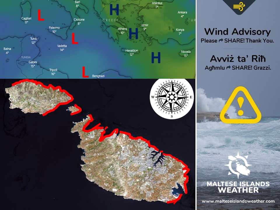
An area of instability will settle over the central Mediterranean from Thursday 02/04 till Saturday 04/04. Higher pressure will prevail over Greece, Turkey and the eastern Mediterranean. This will cause a strong, cool breeze to blow across the Maltese Islands. The wind will not be too strong, but it may strengthen to Force 7 at times across exposed areas.

This is an ADVISORY, NOT A WARNING. A warning indicates that the forecast conditions may pose a threat to life or property. An advisory indicates that the forecast conditions may pose an inconvenience to daily life. It is of great importance to differentiate between the two terms. This advisory is valid from 09:00 on Thursday 02/04 till noon on Saturday 04/04. It will be updated when and if necessary. The details below describe how the situation should evolve over this time period:

Thursday 02/04

The wind will be from the East to East Northeast. It will be at Force 3/4 till around dawn, before increasing to Force 5/6 during the day. Gusts of up to Force 7 are possible, especially in the early afternoon.

Friday 03/04

The wind will be at Force 5/6 from the East Northeast to Northeast. Gusts of up to Force 7 are possible, especially in the evening and at night.

Saturday 04/04

The wind will be at Force 5/6 from the Northeast to North Northeast till the early afternoon. Gusts of up to Force 7 are possible, especially in the morning. The wind will decrease rapidly in the afternoon, to become Variable Force 2/3.

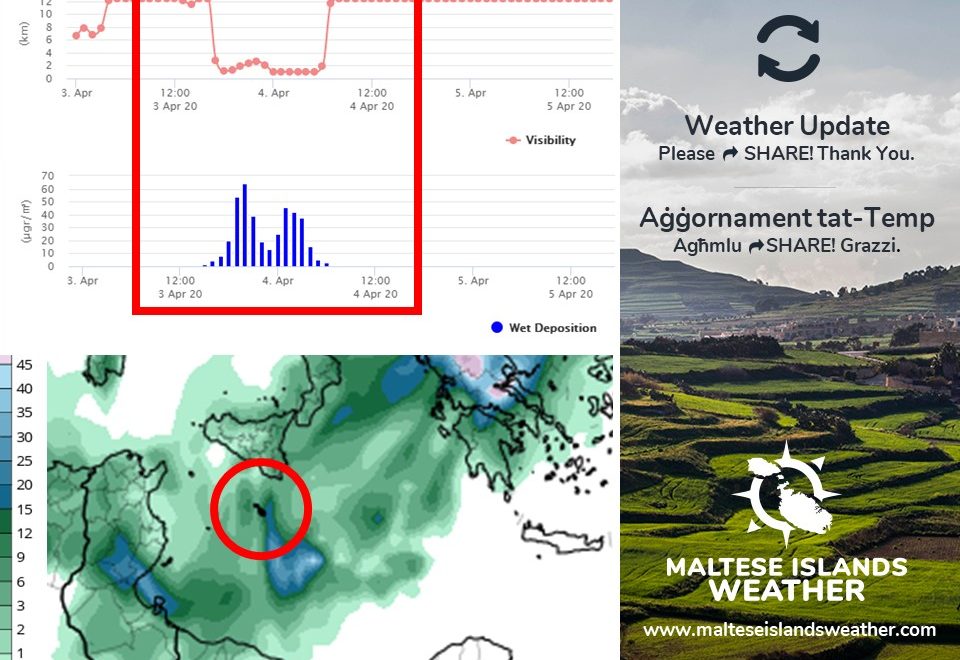
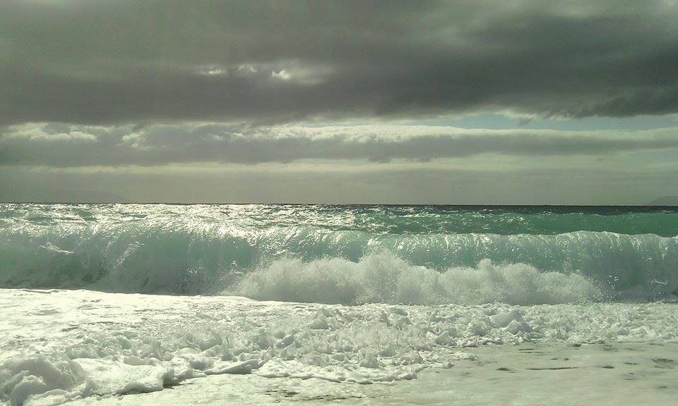
The sea will be moderate to rough, with wave heights of up to 4 metres in peak gusts. The wave direction will veer gradually from the East to North Northeast over the course of these three days. The swell will be low to moderate from the East. The map shows the area of coastline most exposed to this strong wind and rough sea.


Roqgħa ta’ instabbilta’ se tistalla fuq iċ-ċentru tal-Mediterran mill-Ħamis 02/04 sas-Sibt 04/04. Arja bi pressjoni ogħla se tippersisti fuq il-Greċja, t-Turkija u il-lvant tal-Mediterran. Dan se jwassal għal riħ xi ftit qawwi u frisk madwar il-Gżejjer Maltin. Ir-riħ mhux se jkun qawwi esaġerat, imma jaf iżid għal Forza 7 kultant f’inħawi esposti.

Dan huwa AVVIŻ, MHUX TWISSIJA. Twissija tintuża meta l-maltemp imbassar jaf ikun ta’ theddida għal ħajja u propjeta’. Avviż jintuża meta l-maltemp imbassar jaf joħloq inkonvenjenza fil-ħajja ta’ kuljum. Huwa importanti ħafna li tifhmu d-differenza bejn dawn iż-żewġ termini. Dan l-avviż se jkun validu minn 09:00 tal-Ħamis 02/04 sa nofsinhar tas-Sibt 04/04. Dan ikun aġġornat x’ħin u jekk ikun hemm il-bżonn. Id-dettalji ta’ hawn taħt juru kif għandha tiżviluppa s-sitwazzjoni matul dan iż-żmien:

Il-Ħamis 02/04

Ir-riħ se jkun mill-Lvant għal Grieg il-Lvant. Se jkun Forza 3/4 sa tlugħ ix-xemx, qabel ma jżid għal Forza 5/6 matul il-jum. Buffuri ta’ Forza 7 huma possibbli, speċjalment kmieni wara nofsinhar.

Il-Ġimgħa 03/04

Ir-riħ se jkun Forza 5/6 mill-Grieg il-Lvant għal Grigal. Buffuri ta’ Forza 7 huma possibbli, speċjalment filgħaxija u billejl.

Is-Sibt 04/04

Ir-riħ se jkun Forza 5/6 mill-Grigal għal Grieg it-Tramuntana sa kmieni wara nofsinhar. Buffuri ta’ Forza 7 huma possibbli, speċjalment filgħodu. Ir-riħ se jonqos drastikament wara nofsinhar, u jsir Varjabbli Forza 2/3.

Il-baħat se jkun moderat għal qawwi, b’mewġ għoli 4 metri fl-aktar buffuri għoljin. Il-mewġ se jdur bilmod minn Lvant għal Grieg it-Tramuntana matul dawn it-tlett ijiem. L-imbatt se jkun baxx għal moderat mill-Lvant. Din il-mappa turi l-kosta l-aktar esposta għal dan ir-riħ qawwi u baħar imqalleb.

Updates

Becoming unstable again / Jerġa jsir instabbli

Freedom Day brought with it bright sunshine, warm temperatures and light winds. As initially expected, this will be a one-off occurrence. Instability returns to the Maltese Islands from Wednesday 01/04 through to Saturday 04/04. This will be the result of low pressure over north Africa. Skies will be cloudier. Isolated light rain or drizzle may also occur on Friday 03/04 and Saturday 04/04. The wind will be light to moderate at first on Wednesday 01/04, but is expected to turn East to East Northeast by late in the evening. It will then increase to Force 5/6 at times 7 till late on Saturday 04/04. Being of north African origin, this instability will mean some airborne fine desert sand throughout the four days. Any rain will deposit this. Wednesday 01/04 will be off to a warm start, with a 20 C high and 13 C low. It will cool down substantially by Thursday 02/04 though, with 15 C highs and 11 C lows till the weekend.

Jum il-Ħelsien ġab miegħu temp bnazzi, temperaturi sħan u riħ ħafif. Kif kien mistenni, dan it-temp sabiħ se jżomm biss jum wieħed. Instabbilta’ tirritorna lejn il-Gżejjer Maltin minn l-Erbgħa 01/04 sa nhar is-Sibt 04/04 brasil-libido.com. Dan se jkun ir-riżultat ta’ pressjoni baxxa lejn in-naħa ta’ fuq ta’ l-Afrika. Is-sema se jżid fil-kopertura ta’ sħab. Ftit xita ħafifa jew irxiex iżolata tista tmissna nhar il-Ġimgħa 03/04 jew is-Sibt 04/04. Ir-riħ se jkun ħafif għal moderat għal bidu ta’ l-Erbgħa 01/04, imma mistenni jdur Lvant għal Grieg il-Lvant minn tard filgħaxija. Dan se jżid għal Forza 5/6 kultant 7 sa tard is-Sibt 04/04. Peress li se tkun ta’ oriġini Afrikana, din l-instabbilta’ tfisser xi ftit trab fin fl-arja matul dawn il-jiem. Kwalunkwe xita se tkun tal-ħamrija. L-Erbgħa 01/04 se tibda sħuna, bl-ogħla ta’ 20 C u l-anqas ta’ 13 C. Din se tonqos b’mod sostanzzjali mill-Ħamis 02/04, bl-ogħla ta’ 15 C u l-anqas ta’ 11 C sa tmiem il-ġimgħa.

Updates

3 Hourly Forecast for Freedom Day (31/03/2020)

00:00 to 03:00 – clear; 13 C to 12 C; Northwest Force 2/3
03:00 to 06:00 – clear; 12 C to 11 C; Northwest Force 2/3
06:00 to 09:00 – clear; 11 C to 14 C; Northwest Force 2/3 to 3/4
09:00 to 12:00 – clear; 14 C to 18 C; Northwest Force 3/4
12:00 to 15:00 – clear; 18 C to 17 C; Northwest to West Force 3/4
15:00 to 18:00 – clear; 17 C to 16 C; West Force 3/4 to 2/3
18:00 to 21:00 – clear; 16 C to 14 C; West Force 2/3
21:00 to 00:00 – clear; 14 C to 13 C; West Force 2/3

Freedom Day, or Jum il-Ħelsien in Maltese, is a Maltese national holiday celebrated annually on 31 March. This is the anniversary of the withdrawal of British troops and the Royal Navy from Malta in 1979. The Government had been wanting to re-negotiate the lease agreement with the United Kingdom throughout the 1970s. Following protracted and sometimes tense talks, a new agreement was signed whereby the lease was extended till the end of March 1979 at a vastly increased rent. On 31 March 1979 the last British Forces left Malta. For the first time in a millennium, Malta was no longer a military base of a foreign power and it became independent de facto as well as de jure. Normally, the main events of the activities commemorating this date take place at the Freedom Day Monument in Birgu and at the War Memorial in Floriana. In the afternoon, the Grand Harbour would normally host a competitive regatta. For this year, due to the situation with COVID-19, all celebrations are cancelled. Nonetheless, it remains a national holiday.