Updates

For the latest updates related to the weather in the Maltese Islands. So keep yourself updated by visiting this page frequently or like our Facebook page.

Updates

This week: A cloudy start to April

This week will be off to a wet start, as an unstable air mass of Tunisian origin will drench the Maltese Islands with rain. The rain, which will be heavy at times, may push the total rainfall for this month above the average for March. This would make March the first wetter than average month since November. A sunny sky will prevail on Tuesday 31/03. April will start off on a miserable note, however. A cut-off low from over north Africa should cover our skies with featureless grey cloud for much of the time from Wednesday 01/04 through to February 03/04. Some rain is possible on Friday 03/04 too. Once again, sunny skies will return just in time for the weekend. Any rain this week will deposit fine desert sand. The first half of the week will be fairly calm, with the light east wind subtly veering west. Things change on Thursday 02/04, though, when a strong wind from the east is to be expected. Friday 03/04 and Saturday 04/04 will be characterised by a strong wind from the west. Sunday 05/04 will be somewhat calmer. Temperatures will vary widely, with highs of 15 C to 20 C and lows of 9 C to 14 C.

Updates

More rain ahead / Ġejja aktar xita

An unstable air mass has developed over Tunisia. In the coming hours, this unstable air mass will intensify. It will form a mass of rain. A number of isolated thunderstorms may be embedded within. Although very slow-moving, it will make its way to the central Mediterranean. Cloud cover will increase gradually on Sunday 29/03. The mass of rain is expected to reach us overnight, producing rain that will be heavy at times. Any isolated thunderstorms may produce hail. Rainfall will be widespread, and therefore, all of the Maltese Islands should receive their fair share of water. Luckily, atmospheric conditions above the Maltese Islands will not be favourable for severe weather to form. The chance of rain will be highest from 02:00 till 14:00 on Monday 30/03. We may get anywhere between 7.5 mm and 20 mm of rainfall from this.

Massa instabbli żviluppat fuq it-Tuneżija. Matul is-siegħat li ġejjin, din l-arja nstabbli se tintensifika. Se tiżviluppa f’massa ta’ xita. Xi maltempati bir-ragħad iżolati jistgħu jiżviluppaw ġewwa fiha. Għalkemm miexja bilmod, xorta mistennija tilħaq iċ-ċentru tal-Mediterran. L-ammont ta’ sħab se jiżdied matul il-jum tal-Ħadd 29/03. Il-massa ta’ xita mistennija tilħaqna billejl, u se tipproduċi xita li se tkun qawwija f’xi ħinijiet. F’każ ta’ maltempati bir-ragħad iżolati, jaf ikollna s-silġ ukoll. Ix-xita se tkun mifruxa, u għalhekk, il-Gżejjer Maltin kollhja għandhom jaraw xi ftit xita mhux hażin. Fortunatament, il-kundizzjonijiet atmosferiċi fuq il-Gżejjer Maltin mhux se jiffavorixxu l-iżvilupp ta’ maltemp sever. Iċ-ċans ta’ xita se jkun l-ogħla minn 02:00 sa 14:00 ta’ nhar it-Tnejn 30/03. Jaf ikollna bejn 7.5 mm u 20 mm ta’ xita minn din.

Updates

Why is it cooler and wetter lately? Għalfejn qed ikun frisk u b’aktar xita dan l-aħħar?

We are in the last days of March. Normally, we’ll be expecting the weather to start improving gradually. We usually expect steadily rising temperatures, an increase in the number of sunny days and the fading away of strong winds. After a record-breaking drought in the winter months, things really seem to have turned around. It seems like we’re getting having winter weather in spring.

Winter was characterised by a positive North Atlantic Oscillation (NAO). The combination of strong high pressure over the Azores and deep low pressure over Iceland meant that storm systems were prevented from reaching our region. This meteorological situation has long dissolved. Lately, a strong high pressure has developed close to the British Isles. In the coming days, this is set to strengthen and expand to cover large parts of central and northern Europe. The high pressure over those regions has deviated the storm track south, encouraging low pressure from over the Atlantic to reach the Mediterranean instead. Furthermore, air always moves from areas of high pressure towards areas if low pressure. As a result, we are experiencing movement of air from over northern Europe (high pressure) towards the Mediterranean (low pressure). The air from northern Europe is cold. These settings lead to colder and wetter weather for our region, as we’ve experienced in the past days.

This state of affairs will go on for a while. Expect most days to be cool. Some days will also be cloudier and with a chance of rain. Winds will be strong too from time to time.

Ninsabu fl-aħħar jiem ta’ Marzu. Normalment, inkunu nistennew li t-temp jibda jaqleb għal aħjar bilmod. Nibdew nistennew li t-temperaturi jitilgħu gradwalment. Inkunu mxennqa għal jiem twal xemxin u nuqqas ta’ riħ. Wara li kellna xitwa b’nixfa rekord, l-affarijiet vera jidhru li daru. Jidher li qed ikollna temp xitwa fir-rebbiegħa.

Ix-xitwa kienet ikaratteriżżata minn North Atlantic Oscillation (NAO) pożittiva. Kumbinazzjoni ta’ pressjoni għolja qawwija fuq l-Ażores u pressjoni baxxa fonda fuq l-Iżlanda wasslet biex sistemi ta’ maltemp kienu mwaqqfa minn li jersqu lejna. Din is-sitwazzjoni metejoroloġika issa spiċċat. Dan l-aħħar rajna li pressjoni għolja qawwija żviluppat fuq ir-Renju Unit. Fil-jiem li ġejjin, din se tissaħħaħ u tinfirex lejn iċ-ċentru u t-tramuntana ta’ l-Ewropa. Dan kollu wassal biex sistemi ta’ maltemp ġew imbuttati lejn in-nofsinhar, biex b’hekk sistemi ta’ pressjoni baxxa minn fuq l-Atlantiku qed jilħqu l-Mediterran minflok. Apparti minn hekk, l-arja dejjem timxi minn rqajja ta’ pressjoni għolja lejn rqajja bi pressjoni baxxa. Kaġun ta’ dan, qiegħdin nesperjenzaw moviment ta’ arja minn mit-tramuntana ta’ l-Ewropa (pressjoni għolja) lejn il-Mediterran (pressjoni baxxa). L-arja minn fuq it-tramuntana ta’ l-Ewropa hija ta’ temperatura kiesħa. Riżultat ta’ dawn ir-raġunijiet, ir-reġjun tagħna jesperjenza temp aktar kiesaħ u imxarrab bħal ma rajna dan l-aħħar.

Din is-sitwazzjoni mistennija tippersisti għal xi zmien. Stennew li diversi jiem ikunu friski. Xi wħud se jkunu wkoll b’sema msaħħab u b’ċans ta’ xita. Ir-riħ se jkun qawwi minn żmien għal żmien ukoll.

Updates

Summer time begins / Jibda ħin is-sajf

We set clocks forward an hour tonight. The German Empire and its World War I ally Austria-Hungary were the first to use Daylight Saving Time (DST) as a means of conserving coal during wartime. Others followed suit. Numerous countries abandoned it in the years following World War II. Since then, the world has seen several enactments, adjustments, and repeals. Much of Africa, Asia, South America and Oceania do not follow it anymore. There are several arguments about this, both in favour and against. MEPs have voted to end summer and winter time switch in 2021. Each EU country will now have to decide which time it wants to stick to, with clocks changing for the last time in March or October 2021, depending on what member states’ choose. If we stick to summer time, it will be darker in the mornings in winter, but there will be much more light in the evening https://polska-ed.com/kupic-generic-cialis/. If we stick to winter time, there will be more light in the mornings in winter, but it will get dark earlier in the summer. Daylight Saving Time (DST) begins tonight, so do not forget to move your clock forward one hour before going to bed tonight. Tomorrow, the sun rises at 06:52 and sets at 19:21, as summer slowly sets in.

Illejla nmexxu il-ħin siegħa il-quddiem. L-Imperu Ġermaniż u l-alleati tagħhom l-Awstrija-Ungerija kienu l-ewwel li użaw id-Daylight Saving Time (DST) fl-Ewwel Gwerra Dinjija. Dan għamluh biex jikkonservaw il-faħam fi żmien il-gwerra. Oħrajn imxew fl-eżempju tagħhom. Numru ta’ pajjiżi abbandunaw din is-sistema fis-snin ta’ wara i-Tieni Gwerra Dinjija. Minn dakinhar l-hawn, diversi pajjiżi raw promulgazzjoni, aġġustamenti u tibdil. Il-biċċa l-kbira ta’ l-Afrika, l-Asja, l-Amerika ta’ Isfel u l-Awstralja ma għadhomx juzawha din is-sistema. Hemm diversi argument, kemm favur kif ukoll kontra d-Daylight Saving Time (DST). MPEs ivvutaw biex itemmu din is-sistema fl-Ewropa fl-2021. Il-pajjiżi kollha ta’ l-Unjoni Ewropeja issa jridu jiddeċiedu jekk hux se jżommu l-ħin tas-sajf jew dak tax-xitwa. Il-ħin se jinbidel l-aħħar f’Marzu jew Ottubru ta’ l-2021, skont l-għażla tal-istati. Jekk niddeċiedu li nżommu l-ħin tas-sajf, se jkollna aktar dlam filgħodu fix-xitwa, imma aktar dawl filgħaxija. Jekk inżommu l-ħin tax-xitwa, se jkun hemm aktar dawl filgħodu fix-xitwa, imma se jidlam aktar kmieni fis-sajf. Daylight Saving Time (DST) jibda llejla. Għalhekk, tinsewx tmexxu l-arloġġi siegħa ‘l quddiem qabel tidħlu torqdu. Għada x-xemx titla fis-06:52 u tinżel fis-19:21, hekk kif qed joqrob is-sajf.


Updates

Instability to persist / L-instabilita’ se tippersisti

The atmosphere above the central Mediterranean will remain unstable for the rest of March 2020 and possibly into the first days of April 2020. The latest maps reveal that slow-moving low pressure systems will remain stationary over our region for the time being. As a result isolated rain and/or hail showers will remain possible till at least this Wednesday 01/04. Skies will be mainly partly to variably cloudy. Rainfall will be sporadic, and thus, some places may remain completely dry. The wind will be mainly moderate to strong from alternating directions. Temperatures from Friday 27/03 onward will rise to 16 C / 17 C highs and 11 C / 12 C lows.

L-atmosfera fuq iċ-ċentru tal-Mediterran se tibqa instabbli sa l-aħħar ta’ Marzu 2020 u possibilment anke fl-ewwel jiem ta’ April 2020. L-aħħar mapep juru li sistemi ta’ pressjoni baxxa mexjin bilmod ħafna se jibqgħu stazzjonarji fuq ir-reġjun tagħna għalissa. Riżultat ta’ dan, ħalbiet iżolati ta’ xita u/jew silġa ser jibqgħu possibli sa minn l-anqas nhar il-Erbgħa 01/04. Is-sema se jkun il-biċċa l-kbira ftit jew wisq imsaħħab. Ix-xita tkun lokaliżżata, u għalhekk, numru ta’ postijiet jafu ma jaraw xejn xita. Ir-riħ se jkun fil-maġġoranza tiegħu moderat għal qawwi minn direzzjoni li se tvarja. It-temperaturi mill-Ġimgħa 27/03 ‘il quddiem se jżidu għal 16 C / 17 C matul il-jum u 11 C / 12 C billejl.

Updates

More rain and wind ahead / Aktar xita u riħ daqlwaqt

A low pressure system forming over north Africa will traverse the central Mediterranean on Wednesday 25/03 and Thursday 26/03. A warm and dry air mass will accompany this low pressure system. This air mass will clash with the cool and moist air mass locally, causing this low pressure system to intensify rapidly as it moves across our region. The atmospheric pressure at its centre may be as low as 990hPa. Its main impacts on the Maltese Islands will be two separate gales in a space of 48 hours. It will also bring airborne fine desert sand and a bout of showers.

The warm and dry air mass accompanying this low pressure system will carry with it a abundant fine desert sand. It will affect us only partly, with some airborne fine desert sand over the Maltese Islands. The bulk will remain to the south of the Maltese Islands and over the Sahara Desert itself. The airborne fine desert sand may give the air a slight reddish hue on Wednesday 25/03. The air will clear up on Thursday 26/03, as the wind turns Northwest.

A mass of showers will be associated with the centre of the low pressure system. The low pressure system is expected to reach its point of greatest intensity over Sicily, after traversing the Maltese Islands. As such, the heaviest rain will not affect us. Nevertheless, some showers should still affect the Maltese Islands, with a few of these anticipated to be heavy and also possibly thundery at times. Total rainfall may exceed 10 mm in the wettest localities. The rain will be depositing fine desert sand. The chance of rain is highest in the morning on Wednesday 25/03, but showers may still occur at any point from evening on Tuesday 24/03 till morning on Thursday 26/03.

The air temperature will be a mild 16 C / 12 C on Wednesday 25/03, before dipping to a cool 13 C / 9 C on Thursday 26/03.

Sistema ta’ pressjoni baxxa li qed tifforma fl-Afrika ta’ fuq se tgħaddi minn fuq iċ-ċentru tal-Mediterran l-Erbgħa 25/03 u l-ħamis 26/03. Massa ta’ arja sħuna u niexfa hija abbinata ma’ din. Din l-arja se taħbat ma’ l-arja kiesħa u umda’ madwarna, biex b’hekk is-sistema ta’ pressjoni baxxa tintensifika b’ritmu mgħaġġel hi u għaddejha fuq iċ-ċentru tal-Mediterran. Il-pressjoni atmosferika fiċ-ċentru tagħha jaf jinżel sa 990hPa. L-akbar impatt fuq il-Gżejjer Maltin se jkunu żewġ riefni fi spazju ta’ 48 siegħa. Se ġġib magħha wkoll trab fin fl-arja u xi xita.

L-arja sħuna u niexfa li tinsab abbinata ma’ din is-sistema ta’ pressjoni baxxa se tkun qed iġġorr magħha ammont sostanzzjali ta’ trab fin mid-deżert. Dan se jaffetwana biss parzjalment, b’xi trab fin fl-arja fuq il-Gżejjer Maltin. Il-biċċa l-kbira ta’ dan it-trab se jżomm lejn in-nofsinhar tagħna. L-arja taf tidher daqsxejn ħamranija nhar l-Erbgħa 25/03. L-arja se titnaddaf il-Ħamis 26/03, hekk kif ir-riħ idur Majjistral.

Massa ta’ xita se tkun abbinata maċ-ċentru ta’ din is-sistema ta’ pressjoni baxxa. Il-pressjoni baxxa mistenni tilħaq l-aqwa tagħha fuq Sqallija, wara li tgħaddi minn fuq il-Gżejjer Maltin. Għalhekk, ix-xita l-aktar qawwija mhux se tkun qed taħkimna. Madankollu, xi ħalbiet tax-xita xorta waħda għandhom jaffetwawna, bi ftit minn dawn ikun qawwijin u possibilment anke bir-ragħad kultant. It-total ta’ xita jista jaqbeż 10 mm fl-inħawi l-aktar milquta. Ix-xita se tkun tal-ħamrija. Iċ-ċans ta’ xita se jkun l-ogħla l-Erbgħa 25/03 filgħodu, għalkemm xi ħalbiet tax-xita se jkunu possibbli mit-Tlieta 24/03 filgħaxija sal-Ħamis 26/03 filgħodu.

It-temperatura ta’ l-arja se tkun ta’ 16 C / 12 C l-Erbgħa 25/03, qabel ma tinżel 13 C /9 C il-Ħamis 26/03.

Updates

GALE-FORCE WIND WARNING / TWISSIJA TA’ RIEFNU

An intense low pressure system of north African origin will traverse the central Mediterranean on Wednesday 25/03 and Thursday 26/03. This will generate two separate gales: a Scirocco on Wednesday and a Mistral on Thursday.

The Scirocco gale-force wind warning is valid from midnight on Tuesday 24/03 till 18:00 on Wednesday 25/03. The Mistral gale-force wind warning is valid from midnight on Wednesday 25/03 till 15:00 on Thursday 26/03. It will be updated when and if necessary. The details below describe how the situation will develop over this time period:

Wednesday 25/03 

00:00 to 03:00 – East Southeast Force 5/6 to 6/7

03:00 to 06:00 – East Southeast Force 6/7

06:00 to 09:00 – East Southeast Force 6/7 to 7/8

09:00 to 12:00 – East Southeast Force 7/8

12:00 to 15:00 – East Southeast Force 7/8 to 6/7

15:00 to 18:00 – East Southeast Force 6/7 to 5/6

Thursday 26/03

00:00 to 03:00 – West Northwest Force 5/6 to 6/7

03:00 to 06:00 – West Northwest Force 6/7 to 7/8

06:00 to 09:00 – West Northwest Force 7/8

09:00 to 12:00 – West Northwest Force 7/8 to 6/7

12:00 to 15:00 – West Northwest Force 6/7 to 5/6

The peak Scirocco gusts will blow across the Maltese Islands in the morning on Wednesday 25/03. On the other hand, the peak Mistral gusts will blow across the Maltese Islands in morning on Thursday 26/03. They could reach Force 9 across exposed areas of the Maltese Islands.

The wind will appear to die down completely in the evening of Wednesday 25/03. It will then turn West Northwest and increase rapidly again.

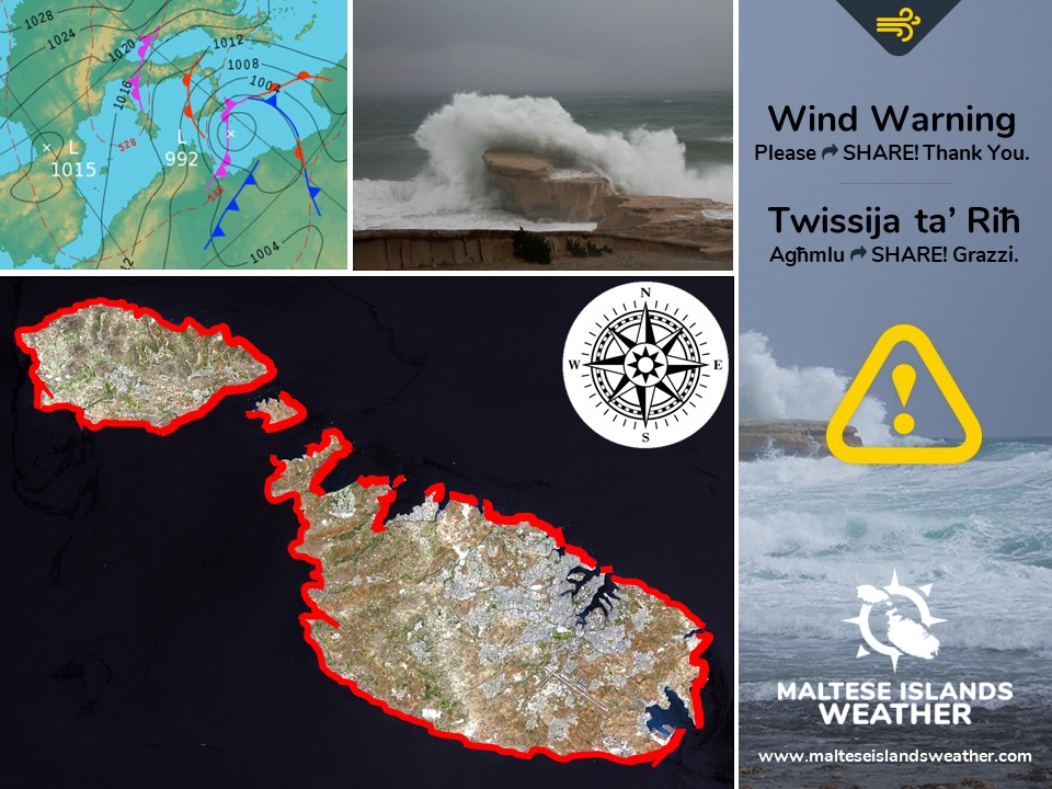
The sea will be very rough, with wave heights of up to 8.5 metres in peak gusts. The swell will be low to moderate East on both days. The map shows the area of coastline most exposed to this strong wind and rough sea.


Sistema ta’ pressjoni baxxa intensa li oriġinat fl-Afrika ta’ fuq se tgħaddi minn fuq iċ-ċentru tal-Mediterran nhar l-Erbgħa 25/03 u l-Ħamis 26/03. Din se tikkaġuna żewġt irwiefen separati: wieħed mix-Xlokk l-Erbgħa u ieħor mill-Majjistral il-Ħamis.

It-twissija għal riefnu mix-Xlokk se tkun fis-seħħ minn nofsillejl tat-Tlieta 24/03 sa 18:00 ta’ l-Erbgħa 25/03. It-tieni twssija, dik għal riefnu mill-Majjistral, se tkun fis-seħħ minn nofsillejl ta’ l-Erbgħa 25/03 sa 15:00 tal-Ħamis 26/03. Dan ikun aġġornat x’ħin u jekk ikun hemm bżonn. Id-dettalji ta’ hawn taħt jindikaw kif se tkun qed tiżviluppa din is-sitwazzjoni matul il-ħin imsemmi:

L-Erbgħa 25/03 

00:00 sa 03:00 – Xlokk il-Lvant Forza 5/6 għal 6/7

03:00 sa 06:00 – Xlokk il-Lvant Forza 6/7

06:00 sa 09:00 – Xlokk il-Lvant Forza 6/7 għal 7/8

09:00 sa 12:00 – Xlokk il-Lvant Forza 7/8

12:00 sa 15:00 – Xlokk il-Lvant Forza 7/8 għal 6/7

15:00 sa 18:00 – Xlokk il-Lvant Forza 6/7 għal 5/6

Il-Ħamis 26/03

00:00 sa 03:00 – Punent Majjistru Forza 5/6 għal 6/7

03:00 sa 06:00 – Punent Majjistru Forza 6/7 għal 7/8

06:00 sa 09:00 – Punent Majjistru Forza 7/8

09:00 sa 12:00 – Punent Majjistru Forza 7/8 għal 6/7

12:00 sa 15:00 – Punent Majjistru Forza 6/7 għal 5/6

Il-buffuri l-aktar qawwija mix-Xlokk se jolqtuna l-Erbgħa 25/03 filgħodu. Il-buffuri l-aktar qawwija mill-Majjistral se jolqtuna l-Ħamis 26/03 filgħodu. Dawn jistgħu jilħqu Forza 9 fl-inħawi l-aktar esposti tal-Gżejjer Maltin.

Ir-riħ se jagħti l-ħjiel li qed jieqaf kumpletament l-Erbgħa 25/03 filgħaxija. Madankollu se jdur Punent Majjistru u jżid f’daqqa.

Il-baħar se jkun imqalleb ħafna, b’mewġ għoli 8.5 metri fil-buffuri l-aktar qawwija. L-imbatt ikun baxx għal moderat mill-Lvant matul il-jumejn li huma. Il-mappa turi l-kosta l-aktar esposta għal dan ir-riħ qawwi u baħar imqalleb.

Updates

World Meteorological Day 2020 – Climate and Water

The date of the establishment of the World Meteorological Organisation (WMO) on 23rd March 1950, was named World Meteorological Day. The organisation announces a slogan for this day every year. This day is celebrated in all member countries (including Malta). The day is marked with conferences, symposia and exhibitions designed for meteorological professionals and the general public alike. This year’s theme is ‘Climate & Water’. One of the biggest impacts of climate change is on water. This, in turn, affects sustainable development and security. Despite this, it remains the least studied of all. Data on water resources is sketchy and incomplete.

Water is life. The average human being cannot survive for more than three days without water. It is shocking to know that, amidst the COVID-19 pandemic, an estimated 3 billion people worldwide lack basic hand washing facilities. Over 2 billion people live in countries experiencing high water stress, while around 4 billion people face severe water scarcity for at least one month every year. By 2050, the world’s demand for fresh water will be 20% / 30% higher than it is today. Furthermore, most rivers and freshwater bodies are trans-boundary. This means that the decision of one country’s authorities on water resource management often have implications for other countries. As a result, water is a potential source of both peace and conflict.

Climate change is impacting snow cover. The snow cover on mountains are the main source of fresh water. Glaciers have been melting for more than three decades, leading to an increase in short-term hazards like landslides and avalanches and a long-term decrease in water security for future generations. A much greater proportion of annual precipitation is now falling in extreme precipitation events, rather than spread more evenly throughout the year, increasing the risk of flash floods. In many parts of the world, seasonal rainfall patterns are becoming more erratic, affecting agriculture and food security and the livelihoods of millions of people. Hunger is on the rise again. 820 million people suffered from hunger in 2018. As a result of climate change, displacement, conflict and violence, the countries in the Horn of Africa are suffering from greater food insecurity. The unprecedented drought in spring 2019, followed by an unusually wet autumn 2019, contributed to the worst locust outbreak in decades.


Updates

This week: Daylight Saving Time to start on a sunny note

The effects of a low pressure system of north African origin will linger on into Monday 23/03. Another, more intense, low pressure system is set to develop over Algeria and migrate east towards Egypt from Tuesday 24/03 till Thursday 26/03. The first three days of this week will be characterised by cloudy skies. Some light rain or drizzle is possible on Monday 23/03. Heavier showers are possible on Tuesday 24/03 and Wednesday 25/03. The wind will blow from an Easterly direction. It will be strong at times, particularly on Wednesday 25/03. This most certainly means abundant airborne fine desert sand. Any rain will deposit this dust. The meteorological situation will change abruptly early on Thursday 26/03, when a low pressure system of European origin developing over Italy migrates towards the central Mediterranean. The wind will turn Northwest and remain strong. This will blow away the airborne fine desert sand. The wind should weaken for the weekend. With the exception of a little light rain or drizzle on Friday 27/03, we will enjoy plenty of bright sunshine at the weekend. A warm 17 C high on Monday will give way to cooler highs of 13 C to 15 C from Tuesday through to Saturday. Warm temperatures return on Sunday. Nighttime lows will range from 9 C to 12 C throughout this week.

Daylight Saving Time begins early on Sunday 29/03. Do not forget to move your clock forward one hour before you go to bed on Saturday night. The sun will rise at 06:52 and set at 19:21 on Sunday, as summer slowly sets in.

Updates

Rain for the weekend / Xita fi tmiem il-ġimgħa

A low pressure system developing over the Sahara Desert will migrate north towards the central Mediterranean this weekend, affecting the Maltese Islands as it does so. The sky will be overcast on both Saturday 21/03 and Sunday 22/03. We will get rain showers too. These will be heavy and also possibly thundery at times. Being of north African origin, the rain will deposit fine desert sand. Total rainfall may reach 20 mm in some areas. The chance of rain is expected to be highest at around noon on Saturday 21/03 and in the morning on Sunday 22/03. The wind’s expected to be from the East Southeast to East on Saturday, before veering East to East Northeast on Sunday. It will reach Force 6/7 at times.

Sistema ta’ pressjoni baxxa li qed tiżviluppa fuq id-Deżert tas-Saħara se tersaq lejn iċ-ċentru tal-Mediterran fi tmiem il-ġimgħa, u se taffetwa l-Gżejjer Maltin. Is-sema se jkun imsaħħab nhar is-Sibt 21/03 u l-Ħadd 22/03. Se jkollna wkoll ħalbiet tax-xita. Dawn se jkunu qawwijin u anke possibilment bir-ragħad kultant. Peress li x-xita se toriġina fl-Afrika ta’ fuq, ix-xita se tkun tal-ħamrija. It-total ta’ xita kapaċi jilħaq 20 mm f’xi nħawi. Ir-riskju ta’ xita mistenni jkun l-ogħla għal ħabta ta’ nofsinhar tas-Sibt 21/03 u filgħodu tal-Ħadd 22/03. Ir-riħ mistenni li jkun Xlokk il-Lvant għal Lvant is-Sibt, qabel ma jdur Lvant għal Grieg il-Lvant il-Ħadd. Se jilħaq Forza 6/7 kultant.