Updates

For the latest updates related to the weather in the Maltese Islands. So keep yourself updated by visiting this page frequently or like our Facebook page.

Updates

Dusty rain on the way / Ġejja x-xita tal-ħamrija

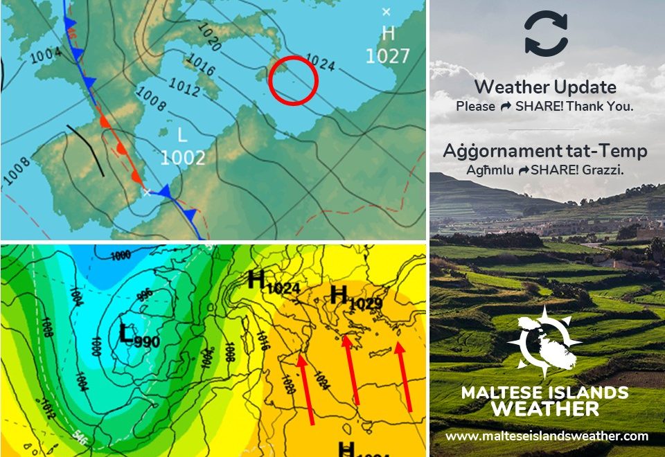
A low pressure system will be moving across north Africa till Monday 27/01. A trough of low pressure associated with this will traverse the central Mediterranean on Sunday night. The warm air carried by this trough will pick up moisture as it passes over the Gulf of Gabes, developing a band of showers. The trough is also carrying abundant amounts of fine desert sand. This will mix with the moisture within the clouds, and fall with the rain. Rain is likely between 21:00 on Sunday 26/01 and 03:00 on Monday 27/01. It could be briefly heavy at times. Total rainfall is expected to range from 2.5 mm to 10 mm. The wind will be from the South leading up to the rainfall, but will turn Northwest overnight. The air will also be very warm ahead of the rain, but will cool significantly afterwards.

Sistema ta’ pressjoni baxxa tinsab għaddejjha minn fuq l-Afrika ta’ fuq sa nhar it-Tnejn 27/01. Front ta’ pressjoni baxxa abbinat ma’ din is-sistema’ se taqsam iċ-ċentru tal-Mediterran il-Ħadd filgħaxija. L-arja sħuna assoċjata ma’ din is-sistema’ se tiġbor ammont ta’ ilma minn fuq il-Golf ta’ Gabes, u tiżviluppa żona ta’ xita. Dan l-istess front qed iġorr ammont ta’ ramel fin minn fuq id-deżert. Dan se jitħallat ma’ l-ilma u jinżel max-xita. Iċ-ċans ta’ xita se jkun l-ogħla minn 21:00 l-Ħadd 26/01 sa 03:00 t-Tnejn 27/01. Din tista tkun qawwija kultant għal ftit ħin. It-total ta’ xita se jvarja minn 2.5 mm sa 10 mm. Ir-riħ se jibqa minn Nofsinhar sakemm tagħmel ix-xita, imbagħad idur Majjistral. L-arja se tkun sħuna qabel ix-xita, imma se tiksaħ ferm wara.

Updates

Dry weather to prevail / In-nixfa se tippersisti

The latest weather models are showing that the pattern of drier than average weather that has prevailed across the Maltese Islands since the beginning of December will continue till at least mid-February. A positive North Atlantic Oscillation (NAO) is responsible for this. In a positive NAO, areas of high pressure over the Azores are stronger than usual. Meanwhile, low pressure systems over Iceland are weaker and less frequent. This meteorological setting means that low pressure systems originating over the Atlantic are prevented from reaching the central Mediterranean. They are deviated north instead. As a result, the Maltese Islands experience a precipitation deficit. The Maltese Islands have received a measly 20.4 mm out of the 203.8 mm we normally expect during the months of December and January. Climate values show that these two months should make up the wettest part of the year. Any rain in the coming weeks will continue to be isolated and infrequent.

L-aħħar mudelli tat-temp qed juru li t-tendenza ta’ temp aktar niexef minn normal għandha tkompli sa minn ta’ l-anqas nofs Frar. It-temp niexef ilu għaddej minn Diċembru. Dan huwa r-riżultat ta’ ‘North Atlantic Oscillation (NAO)’ pożittiva. NAO pożittiva sseħħ meta rqajja ta’ pressjoni għolja fuq l-Ażores ikunu aktar b’saħħithom minn normal. Fl-istess ħin, sistemi ta’ pressjoni baxxa fuq l-Iżlanda jkunu anqas b’saħħithom u frekwenti. Din is-sitwazzjoni tfisser li sistemi ta’ pressjoni baxxa li jiżviluppaw fuq l-Atlantiku ma jitħallewx jilħqu ċ-ċentru tal-Mediterran. Minflok, dawn jiġu mbuttati lejn it-tramuntana. Kaġun ta’ dan, il-Gżejjer Maltin jesperjenzaw nuqqas ta’ xita. Matul Diċembru u Jannar, tkejjlu biss 20.4 mm ta’ xita. Dan hu ferm anqas minn 203.8 mm, il-valur li normalment nirċievu matul dawn ix-xahrejn. Il-klima turina li x-xahrejn ta’ Diċembru u Jannar issoltu jiffurmaw l-aktar parti mxarrba tas-sena. Ix-xita matul il-ġimgħat li ġejjin se tkompli tkun iżolata u infrekwenti.

Updates

This week: It remains extremely dry

A ridge of high pressure will develop over the central Mediterranean, as record-breaking high pressure covers much of Europe. This setting will continue to prevent storm systems from reaching the Maltese Islands. Simultaneously, an intense low pressure system over the western Mediterranean will remain trapped there for the duration of this week. We’re anticipating a mix of clouds and sun for the Maltese Islands this week, with the slight chance of some light rain on Tuesday 21/01. Otherwise, it will be continue to be dry. Temperatures will be stable on weekdays, before rising at the weekend. Highs will vary from 15 C to 18 C, while lows will be in the range of 10 C to 13 C. The difference between a centre of high pressure to our east and an intense low to our west will mean mainly moderate to strong winds from the Southeast throughout this week.

Updates

A very dry January so far … / Jannar niexef ħafna sa issa …

We’re half-way through January 2020, and the weather so far has proved our forecast of a dry January correct. A measly 8.4 mm have been measured over the past fifteen days. Long-term maps are convincing that the next two weeks will see a continuation of the current drier than average weather. With 94.1 mm of rain in a typical January, the first month of the year is supposedly the second wettest month of the year. This year, we will be lucky to reach one fourth of this. Any rain over the next two weeks will continue to be in the form of isolated showers, with long spells of dry weather before and after brief periods of instability.

Ninsabu f’nofs Jannar 2020, u t-temp sa issa wera li konna korretti fi tbassir tagħna li Jannar kien se jkun niexef aktar minn normal. Total fqir ħafna ta’ 8.4 mm ġie mkejjel fl-aħħar ħmistax ‘il jum. L-aħħar mapep fit-tul huma konvinti li l-ħmistax li ġejjin għandhom jaraw kontinwazzjoni ta’ dan it-temp niexef aktar mill-medja. B’medja ta’ 94.1 mm f’Jannar normali, dan ix-xahar huwa normalment it-tieni l-aktar xahar imxarrab tas-sena. Inkunu ferm fortunati, jekk nilħqu kwart ta’ dan l-ammont din is-sena. Ix-xita matul il-ħmistax li ġejjin se tkompli tiġi f’ħalbiet iżolati tax-xita, b’perjodi twal ta’ nixfa qabel u wara episodji ta’ instabbilita’.

Updates

The sunshine returns / Jirritorna temp xemxi

A ridge of high pressure over the western Mediterranean will expand and extend further east towards the central Mediterranean. This will push a low pressure system which has characterised our weather for the past few days to the east. As a result, fine weather will ensue across the Maltese Islands. Till Friday 17/01, we expect partly cloudy skies with plenty of sunshine. The wind will shift to the Northwest. It will remain mainly light to moderate. We’re expecting the air to remain fairly cool, with highs of 14 C / 15 C and lows of 10 C / 11 C. Instability will return this Sunday 19/01 ed-hrvatski.com.

Firxa ta’ pressjoni għolja fuq il-punent tal-Mediterran se tespandi u testendi lejn il-lvant biex toqrob lejn iċ-ċentru tal-Mediterran. Din se timbotta pressjoni baxxa li ġabitilna l-maltemp fl-aħħar jiem lejn il-lvant. B’hekk, nistennew temp bnazzi madwar il-Gżejjer Maltin. Sa nhar il-Ġimgħa 17/01, nistennew sema ftit imsaħħab b’ammont tajjeb ta’ xemx. Ir-riħ se jaqleb lejn il-Majjistral. Se jibqa ħafif għal moderat. L-arja se tibqa friska, bl-ogħla ta’ 14 C / 15 C u l-anqas ta’ 10 C / 11 C. L-instabilita’ se tirritorna nhar il-Ħadd 19/01.

Updates

This week: It starts and ends with rain

Last week saw a mixture of weather conditions. More of the same is expected this week. This week will be off to a wet start. The sun will then shine for a few days, before rain returns towards the end of the weekend. Monday 13/01 and Tuesday 14/01 will see more clouds than sun. There will be some isolated showers too. This will be the result of a low pressure system between the Maltese Islands and Libya. By midweek, a zone of high pressure will develop across the western Mediterranean. This will push the low pressure system away, ensuring fine weather for a few days. A mix of clouds and sun will characterise local weather from Wednesday 15/01 through to Saturday 18/01. This high pressure will be very short-lived, however. Another low pressure will develop over the Gulf of Genoa by Sunday 19/01. It may affect the Maltese Islands with rain by the end of the weekend. A moderate wind from the East Northeast will prevail till midweek. It will turn Northwest and decrease substantially for the second half of the week. Daytime highs are to vary from 14 C to 16 C, while lows will be in the range of 9 C to 11 C.

Updates

The first rain of 2020 / L-ewwel xita ta’ l-2020

A low pressure system over Algeria will migrate slowly eastwards. Meanwhile, an area of high pressure will stand its ground over the Balkans. This will limit the northward movements of the low pressure system. As a result, the Maltese Islands will find themselves sandwiched in between the high pressure over the Balkans and the low pressure over north Africa. The next few days should be characterised by a series of isolated showers which will affect parts of the Maltese Islands at a time. Rain is possible at all times from late on Saturday 11/01 till late on Tuesday 14/01. No major rainfall events are anticipated. The East to East Northeast wind will be strong at all times, especially on Tuesday 14/01, when it will reach Force 6/7 at times. Air temperatures will be stable, with 14 C / 15 C highs and 11 C / 12 C lows.

Despite all the reports and warnings of bad weather making the rounds on social media, we are once again here to assure you that nothing out of the ordinary is expected across the Maltese Islands in the coming days.

Sistema ta’ pressjoni baxxa fuq l-Alġerija se tersaq bilmod lejn il-lvant. Sadattant, roqgħa ta’ pressjoni għolja fuq il-Balkani se żżomm postha. Din se tirrestretta l-movimenti tal-pressjoni baxxa lejn it-tramuntana. B’hekk, il-Gżejjer Maltin se jsibu ruħhom maqbuda bejn il-pressjoni għolja fuq il-Balkani u pressjoni baxxa fuq l-Afrika ta’ fuq. Tul il-jiem li ġejjin se naraw xi ħalbiet iżolati tax-xita li se jaffetwaw xi nħawi tal-Gżejjer Maltin. Xita hija possibbli minn tard is-Sibt 11/01 sa tard it-Tlieta 14/01. Mhux qed nistennew maltempati. Ir-riħ mill-Lvant għal Grieg il-Lvant se jkun qawwi il-ħin kollu, speċjalment it-Tlieta 14/01, meta se jilħaq Forza 6/7 kultant. It-temperatura se tkun stabbli, bl-ogħla ta’ 14 C / 15 C u l-anqas ta’ 11 C / 12 C.

Minkejja ir-rapporti u twissijiet ta’ maltemp qawwi li qed iduru fuq il-midja soċjali, aħna nerġgħu nassigurawkom li dan mhuwiex minnu. Mhu qed nistennew l-ebda maltemp qawwi madwar il-Gżejjer Maltin matul il-jiem li ġejjin.

Updates

Finally, rain is coming / Fl-aħħar, ġejja x-xita

More than a week into 2020, and we’re still waiting for the first rain of the year. January is normally the second wettest month of the year. This year, it is following in the footsteps of December. It is expected to be drier than average. Still, that doesn’t mean a complete lack of rain. High pressure that has continued to cover our region is expected to retreat temporarily, allowing low pressure to infiltrate our region. This could bring some rain to us during the first half of next week, particularly on Monday 13/01 and Tuesday 14/01. Till Saturday 11/01, we will continue to enjoy the bright sunshine and calm winds.

Aktar minn ġimgħa għaddiet minn 2020, u għadna nistennew l-ewwel xita tas-sena. Jannar huwa normalment it-tieni l-aktar xahar imxarrab. Din is-sena jidher li se jkun jixbah lil Diċembru. Mistenni li jkun aktar niexef minn normal. Dan ma jfissirx li mhux ser tagħmel xita. Arja bi pressjoni għolja li ddominat ir-reġjun tagħna mistennija tersaq l’hemm temporanjament, biex b’hekk tippermetti li arja bi pressjoni baxxa tersaq lejna. Dan ifisser li jista jkollna xi ftit xita sewwa fl-ewwel nofs tal-ġimgħa d-dieħla, speċjalment it-Tnejn 13/01 u t-Tlieta 14/01. Sa nhar is-Sibt 11/01, il-Gżejjer Maltin se jkomplu jgawdu minn temp xemxi u riħ ħafif.

Updates

This week: A mixture of weather conditions

This week will bring a true mixture of weather conditions to the Maltese Islands. But how will the weather shape up over the next seven days? Monday 06/01 and Tuesday 07/01 will be bright but cold. Anticyclonic conditions mean two days of uninterrupted bright sunshine. Temperatures will also be rather cold, particularly at night. A front is set to cross the central Mediterranean on Wednesday 08/01 and Thursday 09/01, producing cloudier skies and a little rain. Temperatures will return to average from midweek. Another fine day is anticipated for Friday 10/01, in a break between fronts. Another front will bring some more rain on Saturday 11/01. High pressure will restore fine weather on Sunday 12/01. Maximum temperatures will be at 12 C / 13 C on Monday and Tuesday, before rising fairly to 14 C / 15 C from Wednesday onward. Minimum temperatures will dip to well below, possibly 4 C / 5 C on Tuesday, before rising to 10 C / 11 C from Wednesday onward. Any rainfall will come in isolated showers, with no significant amounts being expected this week.

Updates

Two clear and cold nights / Żewġt iljieli ċari u kesħin

Two cold nights lie ahead for the Maltese Islands. In fact, they may be this winter’s coldest. This is due to clear skies and light winds under anticyclonic conditions. In the cooler months, calm and clear conditions allow heat to be lost from the surface of the Earth to space by radiation. This allows temperatures to fall steadily. As the stable air near to the ground cools, it can become saturated. Saturation leads to the development of mist and fog. For this reason, we urge you to express caution on the road. Patches of dense fog are possible across inland areas. The colder night will be the one from Monday 06/01 into Tuesday 07/01. Temperatures will fall to around 6 C at night, possibly a bit lower inland. Coastal areas tend to be warmer than inland areas, since the warm sea there moderates temperatures there.

Żewġt iljieli ta’ kesħa jidhru li se jaffetwaw lill-Gżejjer Maltin. Filfatt, dawn jistgħu jkunu l-aktar iljieli kesħin ta’ din ix-xitwa. Dan minħabba sema ċar u riħ ħafif ħafna taħt kundizzjonijiet antiċikloniċi. Fix-xhur xitwin, sema ċar u riħ ħafif ħafna jgħin biex is-sħana qrib l-art tintilef lejn l-ispazju. Din twassal biex it-temperatura tonqos sew. Hekk kif l-arja stabbli qrib l-art tiksaħ, din kapaċi tilħaq stat ta’ saturazzjoni. Arja saturata twassal għal iżvilupp ta’ ċpar. Għal din ir-raġuni, se navżawkom biex tkun ferm aktar kawtela fit-triq. Irqajja ta’ ċpar dens jista jifforma f’inħawi lejn iċ-ċentru tal-gżejjer. L-aktar lejl kiesaħ għandu jkun dak ta’ bejn it-Tnejn 06/01 u t-Tlieta 07/01. It-temperatura billejl għandha tinżel sa 6 C, possibilment anqas f’inħawi ċentrali. L-iinħawi tul il-kosta għandhom tendenza li jkunu ferm anqas kesħin minn inħawi entrali, minħabba l-effett tal-baħar.