Updates

For the latest updates related to the weather in the Maltese Islands. So keep yourself updated by visiting this page frequently or like our Facebook page.

Updates

3 Hourly Forecast for New Year’s Day (01/01/2020)

00:00 to 03:00 – partly cloudy; 8 C to 7 C; Northeast to North Force 3/4
03:00 to 06:00 – partly cloudy; 7 C to 8 C; North Force 3/4
06:00 to 09:00 – partly cloudy; 8 C to 12 C; North Force 3/4
09:00 to 12:00 – partly cloudy; 12 C to 14 C; North Force 3/4
12:00 to 15:00 – mainly clear; 14 C to 13 C; North Force 3/4
15:00 to 18:00 – mainly clear; 13 C to 12 C; North Force 3/4
18:00 to 21:00 – mainly clear; 12 C to 11 C; North Force 3/4
21:00 to 00:00 – mainly clear;  11 C to 10 C; North Force 3/4

Updates

3 Hourly Forecast for New Year’s Eve (31/12/2019)

00:00 to 03:00 – variably cloudy with rain and/or hail showers; 9 C to 8 C; East Northeast Force 5/6
03:00 to 06:00 – variably cloudy with rain and/or hail showers; 8 C to 7 C; East Northeast Force 5/6
06:00 to 09:00 – variably cloudy with rain and/or hail showers; 7 C to 9 C; East Northeast Force 5/6
09:00 to 12:00 – variably cloudy with rain and/or hail showers; 9 C to 11 C; East Northeast Force 5/6
12:00 to 15:00 – partly cloudy with the possibility of an isolated shower; 11 C to 13 C; East Northeast Force 5/6
15:00 to 18:00 – partly cloudy; 13 C to 11 C; East Northeast Force 5/6
18:00 to 21:00 – partly cloudy; 11 C to 9 C; East Northeast Force 5/6 to 4/5
21:00 to 00:00 – partly cloudy; 9 C to 8 C; East Northeast to Northeast Force 4/5 to 3/4

Updates

This week: A cold, cold start to 2020

The end of last week marked the start of this season’s first cold snap. The period of cold weather will intensify at the end of 2019 and continue into 2020. An intense low pressure system covering the eastern Mediterranean and parts of the Balkans will persist for much of this week. This will continue drawing frigid air from Russia’s Siberia towards the central Mediterranean. Temperatures will be below average throughout. Maximum temperatures will vary from 10 C on Monday 30/12 to 14 C over the weekend. Minimum temperatures will be at or below 7 C for much of this week, before rising to 8 C / 9 C over the weekend. Winds will be from the North for much of this week, before shifting to the East at the weekend. A series of rain and/or hail showers will occur this week, particularly on Monday 30/12 and Tuesday 31/12. Drier weather is anticipated during the first three days of 2020, before further showers at the weekend. New Year’s Eve will be characterised by rain and/or hail showers during the day, before fading away in the evening. It will be cold with a 12 C high and 7 C high. A Force 5/6 wind from the Northeast will prevail in the daylight hours, before dying down in the evening. New Year’s Day will be brighter with plentiful sunshine and a light wind from the North. A 12 C high and 7 C low will characterise the day.

Updates

Cold days at the door / Jiem ta’ kesħa wara l-bieb

As we’ve been saying for days, cold days are definitely ahead for the Maltese Islands. The first cold snap of the season is now at the door. An intense low pressure system has developed over the eastern Mediterranean and the Balkans. The system has started drawing in frigid air from Russia’s Siberia. This frigid air is already bearing down on eastern Europe, and will spread further south in the coming hours. The Maltese Islands will be affected as well. Starting on Sunday 29/12, air temperatures are set to dip to below the average. The final three days of 2019 will be especially cold. Daytime highs should struggle to reach 11 / 12 C. Lows will dip to 5 C / 6 C. Real feels will be even lower. Monday 30/12 and Tuesday 31/12 will be characterised by a series of rain and/or hail showers. The hail could be abundant in some showers, and might persist over time in shaded spots. The weather will remain cold into the first week of 2020.

Kif ilna ngħidu għal dan l-aħħar jiem, ġejjin ġranet ta’ kesħa għal Gżejjer Maltin. L-ewwel perjodu ta’ bard għal dan l-istaġun tinsab wara l-bieb. Sistema ta’ pressjoni baxxa intensa għadha kemm żviluppat fuq il-lvant tal-Mediterran u l-Balkani. Din is-sistema qed tiġbed arja kiesħa ferm minn fuq is-Siberja tar-Russja. Din l-arja kiesħa diġa qed tmiss il-lvant ta’ l-Ewropa, u għandha tkompli testendi lejn in-nofsinhar fis-siegħat li ġejjin. Il-Gżejjer Maltin se jkunu affetwati wkoll. Minn nhar il-Ħadd 29/12, it-temperaturi ta’ l-arja se jaqgħu taħt il-medja klimatika. L-aħħar tlett ijiem ta’ 2019 se jkunu kesħin sewwa. L-ogħla matul il-jum se jbatu biex jilħqu 11 C / 12 C. L-anqas billejl jinżlu għal 5 C / 6 C. It-temperaturi se jkunu jinħassu ferm aktar kesħin. Nhar it-Tnejn 30/12 u t-Tlieta 31/12 se naraw xi ħalbiet tax-xita u/jew silġ. Is-silġ jaf ikun abbundanti, u jista wkoll jippersisti f’irqajja dellija. It-temp se jibqa kiesaħ fl-ewwel ġimgħa ta’ l-2020 ukoll.

Updates

First cold snap of winter / L-ewwel kesħa tax-xitwa

An intense low pressure system over the eastern Mediterranean will be drawing in frigid air from Russia’s Siberia. This frigid air will impact eastern and southern Europe. The Maltese Islands will be affected by this as well. The air temperature will be colder than average on three days; Sunday 29/12, Monday 30/12 and Tuesday 31/12. The highest temperature on all three days will struggle to reach 12 C. Nighttime lows may dip to 6 C on Monday 30/12. A strong Northeast wind will ensure real-feels much lower than the actual temperature, especially on Monday 30/12 and Tuesday 31/12. A 12 C high will feel more like 8 C. A 6 C low will feel more like 2 C. Some rain and/or hail showers are possible, mainly in the evening of Monday 30/12 and the morning of Tuesday 31/12. This will be one of the few cold snaps this season, amidst an otherwise warmer than average winter.

Sistema ta’ pressjoni baxxa intensa fuq il-lvant tal-Mediterran se tkun qiegħdha tiġbed lejha arja kiesħa ħafna minn fuq is-Siberja tar-Russja. Din l-arja kiesħa ħafna se taffetwa lil pajjiżi tal-lvant u n-nofsinhar ta’ l-Ewropa. Il-Gżejjer Maltin se jkunu affetwati minn din ukoll. L-arja kiesħa se taffetwana l-aktar għal tlett ijiem; il-Ħadd 29/12, it-Tnejn 30/12 u t-Tlieta 31/12. L-ogħla temperatura f’dawn il-jiem se tbati biex tilħaq 12 C. L-anqas temperatura billejl tista tinżel sa 6 C nhar it-Tnejn 30/12. Riħ qawwi mill-Grigal ifisser li dawn it-temperaturi se jkunu jinħassu ferm aktar kesħin., speċjalment nhar it-Tnejn 30/12 u t-Tlieta 31/12. L-ogħla ta’ 12 C tkun tinħass daqs li kieku qiegħdha 8 C. L-anqas ta’ 6 C se tinħass daqs li kieku 2 C. Xi ħalbiet ta’ xita u/jew silġ huma mistennija speċjalment filgħaxija tat-Tnejn 30/12 u filgħodu tat-Tlieta 31/12. Din se tkun waħda mill ftit perjodi ta’ temp kiesaħ dan l-istaġun, hekk kif ix-xitwa se tkun ġeneralment aktar sħuna minn normal.

Updates

3 Hourly Forecast for Christmas Day (25/12/2019)

00:00 to 03:00 – cloudy; 14 C to 15 C; Northwest Force 4/5
03:00 to 06:00 – cloudy; 15 C to 16 C; Northwest Force 4/5 to 5/6
06:00 to 09:00 – cloudy; 16 C to 17 C; Northwest Force 5/6 to 6/7
09:00 to 12:00 – partly cloudy; 17 C to 18 C; Northwest Force 6/7
12:00 to 15:00 – mainly clear; 18 C to 17 C; Northwest Force 6/7 to 5/6
15:00 to 18:00 – mainly clear; 17 C to 16 C; Northwest Force 5/6 to 4/5
18:00 to 21:00 – mainly clear; 16 C to 15 C; Northwest Force 4/5
21:00 to 00:00 – mainly clear; 15 C to 14 C; Northwest Force 4/5

On Christmas Eve, in most villages and towns, one will come across The Children’s procession,whereby children singing Christmas Carols and carrying Christmas lanterns carry the statue of baby Jesus around the village. This tradition is believed to have been started in 1921 by the St.George Preca. Midnight Mass then follows the Children’s Procession. The Mass usually commences with Christmas Carol singing, the most popular Maltese Christmas Carol being, Ninni la Tibqiex Izjed. The highlight of the Mass is the oldest of the Maltese Christmas traditions, the Child’s sermon, A child aged is chosen to recite the Nativity story. In the Maltese Islands, Christmas Day is a time to celebrate with family. The extended family gets together for a long lunch that extends into the evening.

Updates

A mild winter? / Xitwa ħafifa?

Winter is here, and many are wondering what the weather situation will be like on the whole. The Maltese Islands may be on the verge of a brief cold snap, but that doesn’t mean that this winter will be a cold one. The latest long-term maps show that this year’s winter will be mild. That means average or above average temperatures and drier than average weather. It is not straightforward though. Anticyclones over the Azores will be stronger than normal. The atmospheric pressure across Scandinavia will be lower than average. This setting should block air masses of Arctic origin from reaching the central Mediterranean on numerous occasions. Conversely, this will allow air masses of Saharan origin to rise from north Africa into the Mediterranean more freely. This will lead to milder than average temperatures for much of the Mediterranean much of the time. This does not mean that no cold snaps will occur locally. It means that any cold snaps will be brief. They will also be far and few in between. Overall, temperatures should be 0.5 C to 1.0 C warmer than average. Stronger anticyclones over the Azores will mean that storms which normally affect the Mediterranean will be pushed further north. As a result, drier conditions are to be expected for much of the Mediterranean. The Maltese Islands are included in this. A milder-than-average winter does not imply the complete absence of spells of cold and wet weather. These will just be separated by longer than average spells of dry weather. These are the highlights for this winter:

January 2020: Warmer than average temperatures. Drier than average rainfall

February 2020: Warmer than average temperatures. Drier than average rainfall

March 2020: Warmer than average temperatures. Drier than average rainfall


Ix-xitwa waslet, u ħafna qed jistaqsu kif se jkun it-temp matul dan l-istaġun. Huwa vera li l-Gżejjer Maltin jinsabu fil-bidu ta’ perjodu ta’ kesħa, imma dan ma jfissirx li x-xitwa se tkun waħda kiesħa. L-aħħar mapep juru li din ix-xitwa se tkunu waħda ħafifa. Dan ifissier temperaturi mal-medja jew ogħla mill-medja u xita anqas minn normal. Mhux daqshekk faċli pero’. Antiċiklun fuq il-Gżejjer Ażores se jkun aktar b’saħħtu minn normal. Il-pressjoni fuq l-Iskandinavja se tkun anqas minn normal. Din is-sitwazzjoni metejoroloġika se twassal biex masses ta’ arja instabbli minn l-Artiku jiġu miżmuma minn li jilħqu ċ-ċentru tal-Mediterran. Fl-istess waqt, masses ta’ arja minn fuq l-Afrika ta’ fuq se jkunu jistgħu jersqu ‘l fuq b’mod aktar faċli. Dan se jwassal biex it-temperatur madwar il-Mediterran ikunu ogħla mill-medja frekwentament. Dan ma jfissirx li mhux se jkollna waqtiet ta’ ksieħ u bard. Dan ifisser li waqtiet ta’ ksieħ u bard se jkunu qosra u mhux daqstant frekwenti. It-temperaturi se jkunu 0.5 C sa 1.0 C ogħla mill-medja. L-antiċikluni aktar b’saħħithom fuq il-Gżejjer Ażores ifissru li l-maltemp fuq l-Atlantiku se jkun imbuttat ‘il fuq ħafna drabi, flok jilħaq iċ-ċentru tal-Mediterran. Għaldaqstant, it-temp għandu jkun aktar niexef minn normal. Il-Gżejjer Maltin huma nklużi f’dan. Xitwa aktar ħafifa mill-medja ma jfissirx li se tkun xitwa nieqsa minn kull kesħa. Ifisser biss li l-kesħa se tkun f’perjodi qosra. Dawn huma d-dettalji għal din ix-xitwa:

Jannar 2020: Aktar sħun minn normal. Anqas xita minn normal.

Frar 2020: Aktar sħun minn normal. Anqas xita minn normal.

Marzu 2020: Aktar sħun minn normal. Anqas xita minn normal.


Updates

This week: Windy at first, calmer later

Last week was characterised by warm and dry weather, fanned by southerly winds. This week will be altogether very different. A an area of high pressure that sat over the central Mediterranean for much of this week will dissolve. This will allow a low pressure system from the west to migrate eastwards, filling up the void. This shall bring changeable weather conditions to the Maltese Islands. A little rain is possible on Monday 23/12, as a weak front will traverse the central Mediterranean. This quickly gives way to partly cloudy skies, paving the way for another largely dry week. A slight dip in air temperatures is anticipated for this week. Highs will vary from 17 C to 19 C. Lows will be in the range of 11 C to 14 C. The passage of a low pressure system in the first half of this week will imply strong Northwest winds till Christmas Day. A ridge of high pressure will again be a major influencing factor from Boxing Day onward. Winds will be mainly light and variable from then on. With the exception of a few isolated showers on Monday, significant rainfall is highly unlikely this week. This year’s Christmas Eve and Christmas Day will be windy but dry, with a partly cloudy sky.

Updates

The weather for New Year’s? / It-temp għal l-Ewwel tas-Sena?

It’s still early days, but we have the initial maps for New Year’s Eve and New Year’s Day. From our interpretation of these maps, preliminary indications are that the weather will be somewhat more unstable than on Christmas Eve and Christmas Day. The level of confidence is quite high. As things stand, we expect partly to variably cloudy skies with the possibility of isolated rain/hail showers on New Year’s Eve. New Year’s Day will be finer, with plentiful sunshine throughout the day. With highs of below 15 C and lows of around 7 C, both days will see some colder temperatures than as of recent. The wind should be strong from the Northeast on New Year’s Eve, before decreasing somewhat on New Year’s Day.

Għadu kmieni, imma għandna l-ewwel mapep tat-temp għal Lejlet l-Ewwel tas-Sena u Jum l-Ewwel tas-Sena. Mill-interpretazzjoni tagħna ta’ dawn il-mapep, l-ewwel indikazzjonijiet qed juru li t-temp għandu jkun xi daqsxejn aktar intsballi minn Lejlet il-Milied u Jum il-Milied. Il-livell ta’ kunfidenza huwa pjuttost għoli. Kif inhuma l-affarijiet, jidher li se jkollna sema ftit jew wisq imsaħħab u bil-possibilita ta’ ħalbiet tax-xita u/jew silġ iżolati nhar Lejlet l-Ewwel tas-Sena. Jum l-Ewwel tas-Sena se jkun aħjar, b’ammont sostanzzjali ta’ xemx matul il-jum kollu. Bl-ogħla ta’ anqas minn 15 C u l-anqas ta’ madwar 7 C, il-jumejn li huma se jkun ferm aktar kesħin minn dan l-aħħar. Ir-riħ għandu jkun qawwi mill-Grigal f’Lejlet l-Ewwel tas-Sena, qabel ma jonqos daqsxejn f’Jum l-Ewwel tas-Sena.

Updates

GALE-FORCE WIND WARNING / TWISSIJA TA’ RIEFNU

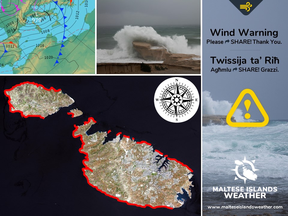
A depression will form over the Gulf of Genoa. Simultaneously, a ridge of high pressure will take its place to the east. This difference in pressure will generate a gale across the central Mediterranean. This gale is set to be the third this season. This gale warning is valid from 09:00 on Sunday 22/12/2019 till 09:00 on Tuesday 24/12/2019, but will be updated when and if necessary. The details below describe how the situation will develop over this time period.


Sunday 22/12

09:00 to 12:00 – West Southwest to West Force 5/6 to 6/7

12:00 to 15:00 – West to West Northwest Force 6/7

15:00 to 18:00 – West Northwest Force 6/7 to 7/8

18:00 to 21:00 – West Northwest Force 7/8

21:00 to 00:00 – West Northwest Force 7/8 to 6/7


Monday 23/12

00:00 to 03:00 – West Northwest Force 6/7

03:00 to 06:00 – West Northwest to West Force 6/7 to 7/8

06:00 to 09:00 – West to West Northwest Force 7/8 to 8/9

09:00 to 12:00 – West Northwest Force 8/9

12:00 to 15:00 – West Northwest to Northwest Force 8/9

15:00 to 18:00 – Northwest Force 8/9 to 7/8

18:00 to 21:00 – Northwest Force 7/8

21:00 to 00:00 – Northwest Force 7/8


Tuesday 24/12

00:00 to 03:00 – Northwest Force 7/8 to 6/7

03:00 to 06:00 – Northwest Force 6/7

06:00 to 09:00 – Northwest Force 6/7 to 5/6


The peak gusts will blow across the Maltese Islands in the morning on Monday 23/12. They might reach Force 10 across exposed areas of the Maltese Islands.

The sea will be very rough, with wave heights of up to 8.5 metres in peak gusts. The swell will be a low West. The map shows the area of coastline most exposed to this strong wind.


Sistema ta’ pressjoni baxxa intensa se tiżviluppa fuq il-Golf ta’ Genoa. Sadattant, firxa ta’ pressjoni għolja se tkun qed tieħu posta lejn il-lvant ta’ din. Id-differenza fil-pressjoni atmosferika se twassal għal riefnu mill-Majjistral fiċ-ċentru tal-Mediterran. Dan se jkun it-tielet riefnu ta’ l-istaġun. Din it-twissija ta’ riefnu tkun fis-seħħ minn 09:00 tal-Ħadd 22/12 sa 09:00 tat-Tlieta 24/12, imma tista tkun aġġornata. Id-dettalji ta’ hawn taħt juru kif se tiżviluppa s-sitwazzjoni matul dan il-ħin.


Il-Ħadd 22/12

09:00 sa 12:00 – Punent Lbiċ għal Punent Forza 5/6 għal 6/7

12:00 sa 15:00 – Punent għal Punent Majjistru Forza 6/7

15:00 sa 18:00 – Punent Majjistru Forza 6/7 għal 7/8

18:00 sa 21:00 – Punent Majjistru Forza 7/8

21:00 sa 00:00 – Punent Majjistru Forza 7/8 għal 6/7


It-Tnejn 23/12

00:00 sa 03:00 – Punent Majjistru Forza 6/7

03:00 sa 06:00 – Punent Majjistru għal Punent Forza 6/7 għal 7/8

06:00 sa 09:00 – Punent għal Punent Majjistru Forza 7/8 għal 8/9

09:00 sa 12:00 – Punent Majjistru Forza 8/9

12:00 sa 15:00 – Punent Majjistru għal Majjistral Forza 8/9

15:00 sa 18:00 – Majjistral Forza 8/9 għal 7/8

18:00 sa 21:00 – Majjistral Forza 7/8

21:00 sa 00:00 – Majjistral Forza 7/8


Tuesday 24/12

00:00 sa 03:00 – Majjistral Forza 7/8 għal 6/7

03:00 sa 06:00 – Majjistral Forza 6/7

06:00 sa 09:00 -Majjistral Forza 6/7 għal 5/6


L-aktar buffuri qawwijin mistennija matul filgħodu tat-Tnejn 23/12. Dawn jistgħu jilħqu Forza 10 fl-inħawi l-aktar esposti tal-Gżejjer Maltin.

Il-baħar se jkun imqalleb ħafna, b’mewġ għoli 8 metri fl-aktar buffuri qawwijin. L-imbatt se jkun ħafif mill-Punent. Il-mappa turi l-kosta l-aktar esposta għal dan ir-riħ.