Updates

For the latest updates related to the weather in the Maltese Islands. So keep yourself updated by visiting this page frequently or like our Facebook page.

Updates

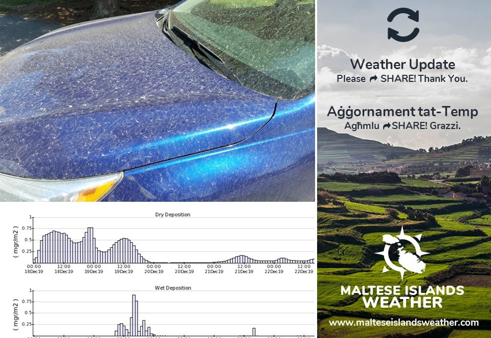
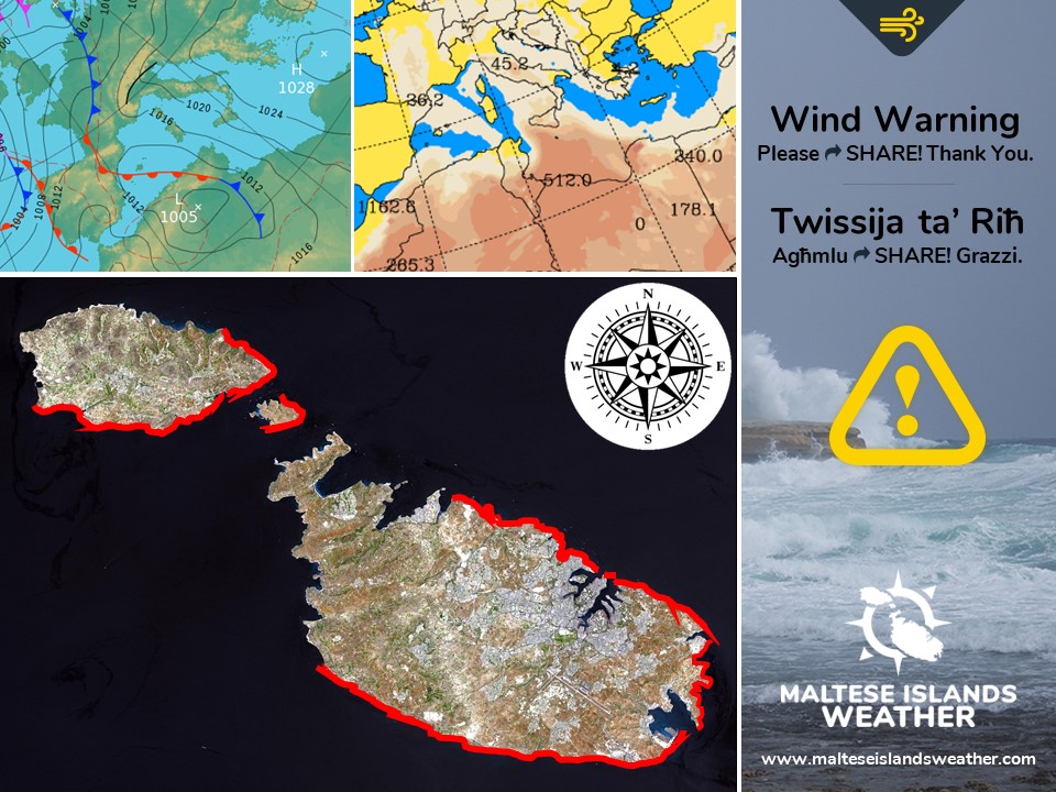
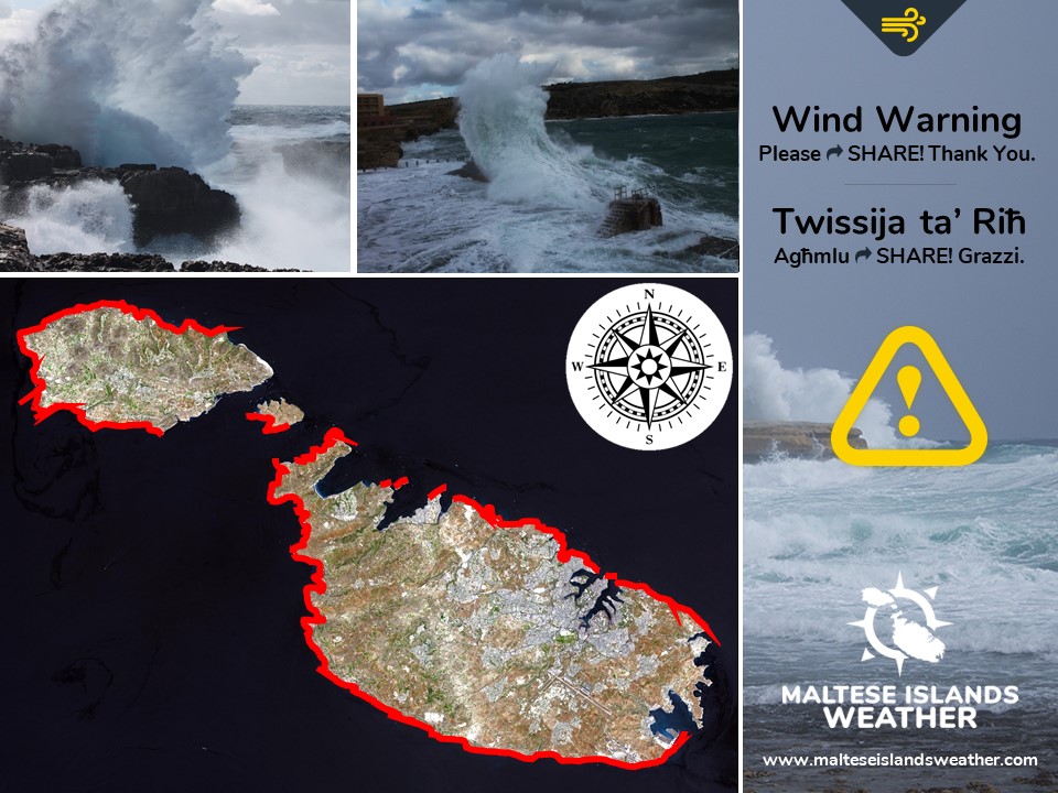
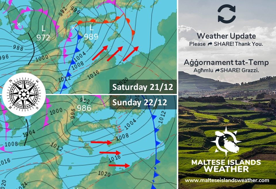
More windy weather ahead / Ġej aktar temp mirjieħ

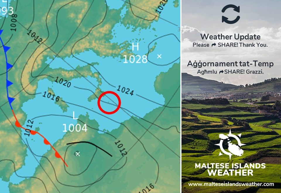
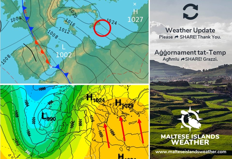
An intense low pressure system will traverse the north of Italy over the weekend. A cold front associated with this will be affecting the central Mediterranean. Ahead of the cold front, on Saturday 21/12, the Southwest wind will reach Force 5/6 at times. After the passage of the cold front, on Sunday 22/12, the wind will veer Northwest. This will increase rapidly to gale-force in the afternoon. The gale, the third of the season, peaks on Monday 23/12. It should blow at Force 9, with gusts of up to Force 10, across exposed areas. The wind will decrease to Force 5/6 by evening. It will remain at Force 5/6 from the Northwest to West Northwest throughout both Christmas Eve and Christmas Day. It backs East and dies down on Boxing Day. With regards to rain, only a little light rain is possible, mainly on Sunday 22/12. Otherwise, it will remain completely dry.

Sistema ta’ pressjoni baxxa intensa se tgħaddi minn fuq in-naħar ta’ fuq ta’ l-Italja fi tmiem il-ġimgħa. Front kiesaħ assoċjat ma’ din se jinteressa ċ-ċentru tal-Mediterran. Qabel ma jaqsam il-front, nhar is-Sibt 21/12, ir-riħ mill-Lbiċ se jilħaq Forza 5/6 kultant. Wara li jaqsam il-front, nhar il-Ħadd 22/12, ir-riħ se jdur Majjistral. Dan se jżid malajr għal qawwa ta’ riefnu wara nofsinhar. Ir-riefnu, it-tielet f’dan l-istaġun, jilħaq l-aqwa tiegħu t-Tnejn 23/12. Għandu jonfoħ b’qawwa ta’ Forza 9, b’buffuri ta’ Forza 10, fl-inħawi l-aktar esposti. Ir-riħ għandu jonqos għal Forza 5/6 sa filgħaxija. Mistenni jibqa Forza 5/6 mill-Majjistral għal Punent Majjistru f’Lejlet il-Milied u Jum il-Milied. Wara se jdur Lvant u jonqos għal kollox l-għada tal-Milied. Fejn tidħol xita, xi ftit xita ħafifa jew irxiex huma possibbli nhar il-Ħadd 22/12. Apparti dan, it-temp se jibqa pjuttost niexef.

Updates

A little dusty rain / Ftit xita tal-ħamrija

An unseasonable shower of dusty is possible overnight. A low pressure system over the Atlas Mountains in Algeria will migrate northeastwards towards Sardinia. This will pick up moisture as it traverses the Mediterranean. In turn, a number of isolated showers will develop within the system. At least one of these might affect the Maltese Islands overnight. The same system has generated a strong wind from the Southeast across our region. This has blown fine desert sand from the Sahara Desert towards the central Mediterranean. As a result, any rain will deposit this sand. Total rainfall will be very low.

Xi ħalba xita tal-ħamrija barr minn l-istaġun hija possibli matul il-lejl. Sistema ta’ pressjoni baxxa fuq il-muntanji Atlas ġewwa l-Alġerija se timxi ‘l fuq lejn Sardenja. Din se takkumula ammont ta’ ilma minn fuq il-Mediterran. Dan se jwassal biex jiżviluppaw numru ta’ ħalbiet iżolati tax-xita. Minn ta’ l-anqas waħda minn dawn tista taffetwa lill-Gżejjer Maltin billejl. L-istess sistema wasslet biex riħ qawwi mix-Xlokk ħakimna. Dan ġab miegħu ammont ta’ trab fin minn fuq id-deżert lejn iċ-ċentru tal-Mediterran. Riżultat ta’ dan, ix-xita li mistennija billejl tkun tal-ħamrija. It-total ta’ xita se jkun wieħed baxx.

Updates

20 C + temperatures till Christmas / Temperaturi ta’ 20 C + sal-Milied

Many are asking: How will the weather shape up in the run-up to Christmas Day? It’s simple. The Maltese Islands will continue to find themselves sandwiched in between high pressure to the east, and low pressure to the west. It’s the meteorological setup that will ensure southerly to westerly winds across the central Mediterranean. This wind will blow warm air from over the Sahara Desert towards our region, maintaining maximum temperatures of 20 C + till Christmas Day or Boxing Day. Nighttime lows should not dip to below 14 C. Also, there will be very little, if any, rainfall till then. If this happens, it will prove us correct. We had predicted a warmer and drier December.

Ħafna qed jistaqsu: Kif se jkun it-temp fil-jiem ta’ qabel il-Milied? Sempliċi. Il-Gżejjer Maltin għandhom jibqgħu jsibu ruħhom maqbudin bejn pressjoni għolja lejn il-lvant, u pressjoni baxxa lejn il-punent. Din se tkun il-kaġun li riħ minn nofsinhar għal punent jipprevjeni madwar iċ-ċentru tal-Mediterran. Dan ir-riħ se jonfoħ arja sħuna minn fuq id-deżert tas-Sahar lejn ir-reġjun tagħna, u b’hekk iżomm l-ogħla temperaturi 20 C + sa Jum il-Milied jew l-għada. L-anqas billejl mhux mistennija jinżlu taħt 14 C. Minbarra hekk, se jkollna ftit li xejn xita sa dakinhar. Jekk dan iseħħ, jfisser li aħna konna korretti. Aħna konna għidna li Diċembru se jkun aktar sħun u niexef minn normal.

Updates

STRONG WIND WARNING / TWISSIJA TA’ RIĦ QAWWI

A low pressure system will be traversing the Atlas Mountains in Algeria. Meanwhile, an anticyclone will be present over the eastern Mediterranean. This meteorological situation will draw air from over the Sahara Desert. This will manifest itself as a strong wind from the Southeast. The wind will not be extremely strong, but taking all necessary precautions is advised. This wind warning is valid from 18:00 on Tuesday 17/12 till 18:00 on Wednesday 18/12. It will develop as described below.


Tuesday 17/12

18:00 to 21:00 – Southeast Force 5/6 to 6/7

21:00 to 00:00 – Southeast to South Southeast Force 6/7


Wednesday 18/12

00:00 to 03:00 – South Southeast to Southeast Force 6/7

03:00 to 06:00 – Southeast Force 6/7

06:00 to 09:00 – Southeast Force 6/7 to 7/8

09:00 to 12:00 – Southeast to South Southeast Force 7/8

12:00 to 15:00 – South Southeast Force 7/8 to 6/7

15:00 to 18:00 – South Southeast to South Force 6/7 to 5/6


The peak gusts will blow across the Maltese Islands just before noon on Wednesday 18/12, and could reach Force 8 in exposed areas. The wind will veer Southwest and decrease to Force 4/5 by late evening on Wednesday 18/12.

The sea will be rough to very rough, with wave heights of up to 5 metres in peak gusts. The swell will be low at times moderate from the Southeast. The map shows the length of coastline most exposed to this strong wind.


Sistema ta’ pressjoni baxxa se tgħaddi minn fuq il-muntanji Atlas f’Alġerija. Sadattant, antiċiklun se jkun qed iżomm postu fuq il-lvant tal-Mediterran. Din is-sitwazzjoni metejoroloġika se toħloq riħ minn fuq id-deżert Sahara. Dan ser jinħass bħala riħ qawwi mix-Xlokk. Ir-riħ mhux se jkun qawwi ħafna, imma l-prekawzzjonijiet meħtieġa għandhom jittieħdu xorta waħda. Din it-twissija ta’ riħ qawwi tkun fis-seħħ minn 18:00 tat-Tlieta 17/12 sa 18:00 ta’ l-Erbgħa 18/12. Id-dettalji ta’ hawn taħt juru kif se tiżviluppa s-sitwazzjoni matul dan il-ħin.


It-Tlieta 17/12

18:00 sa 21:00 – Xlokk Forza 5/6 għal 6/7

21:00 sa 00:00 – Xlokk għal Nofsinhar ix-Xlokk Forza 6/7


Wednesday 18/12

00:00 to 03:00 – Nofsinhar ix-Xlokk għal Xlokk Forza 6/7

03:00 to 06:00 – Xlokk Forza 6/7

06:00 to 09:00 – Xlokk Forza 6/7 għal 7/8

09:00 to 12:00 – Xlokk għal Nofsinhar ix-Xlokk Forza 7/8

12:00 to 15:00 – Nofsinhar ix-Xlokk Forza 7/8 għal 6/7

15:00 to 18:00 – Nofsinhar ix-Xlokk għal Nofsinhar Forza 6/7 għal 5/6


Il-buffuri l-aktar qawwija mistennija qabel nofsinhar ta’ l-Erbgħa 18/12, u kapaċi jilħqu Forza 8 f’postijiet esposti. Ir-riħ idur Lbiċ u jonqos għal Forza 4/5 sa tard filgħaxija ta’ l-Erbgħa 18/12.

Il-baħar se ikun imqalleb għal imqalleb ħafna, b’mewġ għoli 5 metri fl-aktar buffuri qawwija. L-imbatt se jkun baxx għal moderat mix-Xlokk. Il-mappa tindika l-kosta l-aktar esposta għal dan ir-riħ.

Reports, Updates

This week: A warm and humid southerly wind to prevail

It’s been a windy and rather wet week for the Maltese Islands. The low pressure system that brought days of unstable weather to our shores has moved east, allowing an area of high pressure to take over. This area of high pressure will strengthen. This will ensure fine weather on most days this week. There will be plenty of sunshine on most days, with the exception of a day or two, when lots of high clouds are to be expected. No significant rainfall is being anticipated this week. Some nights will be characterised by mist or fog patches and some heavy dewfall, however. The wind is set to shift to the South, and remain so till the weekend, when it will back Northwest again. It will be moderate to strong on most days. Temperatures will rise again. Throughout the week, highs will range between 19 C and 21 C. On the other hand, lows will vary from a more seasonal 12 C to a rather warm 17 C.

Updates

The weather for Christmas? / It-temp għal Milied?

It’s still early days, but we have the initial maps for Christmas Eve and Christmas Days. From our interpretation of these maps, preliminary indications are that the weather will be fine on both days. The level of confidence is quite high. As things stand, we expect partly cloudy skies with a 19 C high and 12 C low on the two days. The wind should be light from the West.

Għadu kmieni, imma għandna l-ewwel mapep tat-temp għal Lejlet il-Milied u Jum il-Milied. Mill-interpretazzjoni tagħna ta’ dawn il-mapep, l-ewwel indikazzjonijiet juru li t-temp għandu jkun bnazzi fil-jumejn li huma. Il-livell ta’ kunfidenza huwa pjuttost għoli. Kif inhuma l-affarijiet, jidher li se jkollna sema ftit imsaħħab bl-ogħla ta’ 19 C u bl-anqas ta’ 12 C f’dawk il-ġranet. Ir-riħ għandu jkun ħafif mill-Punent.

Updates

Getting warmer again / It-temperature terġa togħla

Warmer and drier weather is on the cards for the Maltese Islands from Sunday 15/12. A zone of high pressure will build up across the eastern Mediterranean. Its edge will extend towards the central Mediterranean. Meanwhile, an area of low pressure will be present over the Iberian Peninsula. This setting of pressure systems will cause a shift in wind direction to the South. The southerly wind will blow warmer air from over the Sahara Desert towards us. The air will also be humid. Starting from Sunday, and lasting till the weekend, temperatures will once again rise to 20 C during the day. At 14 C or above, nighttime lows will also be warmer than recent days. The wind will be mainly moderate to strong from the South.

Temp aktar sħun u niexef mistenni madwar il-Gżejjer Maltin minn nhar il-Ħadd 15/12. Żona ta’ pressjoni għolja se tieħu posta fuq il-lvant tal-Mediterran. It-tarf tagħha se jestendi sa fuq iċ-ċentru tal-Mediterran. Sadattant, zona ta’ pressjoni baxxa se żżomm posta fuq il-Penisola Iberika. Din is-sitwazzjoni metejoroloġika se twassal biex ir-riħ idur minn Nofsinhar. Ir-riħ minn isfel se jġib miegħu arja aktar sħuna minn fuq id-deżert tas-Sahara. L-arja tkun umda wkoll. Minn nhar il-Ħadd, sa tmiem il-ġimgħa, it-temperaturi se jogħlew għal 20 C matul il-jum. B’temperatura ta’ 14 C jew aktar, l-iljieli se jkunu anqas kesħin minn dan l-aħħar ukoll. Ir-riħ mistenni jkun moderat jew qawwi minn Nofsinhar.

Updates

SEVERE GALE-FORCE WIND WARNING / TWISSIJA TA’ RIEFNU QAWWI ĦAFNA

A depression will form over the Gulf of Genoa. Simultaneously, a ridge of high pressure will take its place to the east. This difference in pressure will generate a severe gale across the central Mediterranean. This severe gale warning is valid from 15:00 on Friday 13/12/2019 till 21:00 on Saturday 14/12/2019, but will be updated when and if necessary. The details below describe how the situation will develop over this time period.


Friday 13/12

15:00 to 18:00 – West Southwest Force 5/6 to 6/7

18:00 to 21:00 – West Southwest Force 6/7 to 7/8

21:00 to 00:00 – West Southwest to West Force 7/8


Saturday 14/12

00:00 to 03:00 – West to West Northwest Force 7/8 to 8/9

03:00 to 06:00 – West Northwest to Northwest Force 8/9

06:00 to 09:00 – Northwest Force 8/9

09:00 to 12:00 – Northwest Force 8/9 to 7/8

12:00 to 15:00 – Northwest Force 7/8

15:00 to 18:00 – Northwest Force 7/8 to 6/7

18:00 to 21:00 – Northwest Force 6/7 to 5/6


The peak gusts will blow across the Maltese Islands just before dawn on Saturday 14/12. They may reach Force 10 across exposed areas of the Maltese Islands.

The sea will be very rough, with wave heights of up to 9 metres in peak gusts. The swell will be a moderate West to Northwest. The map shows the area of coastline most exposed to this strong wind.


Sistema ta’ pressjoni baxxa intensa se tiżviluppa fuq il-Golf ta’ Genoa. Sadattant, firxa ta’ pressjoni għolja se tkun qed tieħu posta lejn il-lvant ta’ din. Id-differenza fil-pressjoni atmosferika se twassal għal riefnu qawwi ħafna fiċ-ċentru tal-Mediterran. Din it-twissija ta’ riefnu qawwi ħafna se tkun fis-seħħ minn 15:00 sal-Ġimgħa 13/12/2019 sa 21:00 tas-Sibt 14/12/2019, imma tista tkun aġġornata. Id-dettalji ta’ hawn taħt juru kif se tiżviluppa s-sitwazzjoni matul dan il-ħin.


Il-Ġimgħa 13/12

15:00 sa 18:00 – Punent Lbiċ Forza 5/6 għal 6/7

18:00 sa 21:00 – Punent Lbiċ Forza 6/7 għal 7/8

21:00 sa 00:00 – Punent Lbiċ għal-Punent Forza 7/8


Is-Sibt 14/12

00:00 sa 03:00 – Punent għal Punent Majjistru Forza 7/8 għal 8/9

03:00 sa 06:00 – Punent Majjistru għal Majjistral Forza 8/9

06:00 sa 09:00 – Majjistral Forza 8/9

09:00 sa 12:00 – Majjistral Forza 8/9 għal 7/8

12:00 sa 15:00 – Majjistral Forza 7/8

15:00 sa 18:00 – Majjistral Forza 7/8 għal 6/7

18:00 sa 21:00 – Majjistral Forza 6/7 għal 5/6


L-aktar buffuri qawwijin mistennija qabel tlugħ ix-xemx nhar is-Sibt 14/12. Dawn jistgħu jilħqu Forza 10 fl-inħawi l-aktar esposti tal-Gżejjer Maltin.

Il-baħar se jkun imqalleb ħafna, b’mewġ għoli 9 metri fl-aktar buffuri qawwijin. L-imbatt ikun moderat mill-Punent għal-Majjistral. Il-mappa turi l-kosta l-aktar esposta għal dan ir-riħ.

Updates

3 Hourly Forecast for Republic Day (13/12/2019)

00:00 to 03:00 – isolated showers; 14 C to 13 C; West Force 5/6
03:00 to 06:00 – isolated showers; 13 C to 12 C; West Force 5/6
06:00 to 09:00 – isolated showers; 12 C to 14 C; West Force 5/6
09:00 to 12:00 – partly to variably cloudy; 14 C to 16 C; West to West Southwest Force 5/6
12:00 to 15:00 – partly to variably cloudy; 16 C to 17 C; West Southwest Force 5/6 to 6/7
15:00 to 18:00 – isolated showers; 17 C to 16 C; West Southwest Force 6/7
18:00 to 21:00 – isolated showers; 16 C to 15 C; West Southwest Force 6/7 to 7/8
21:00 to 00:00 – isolated showers; 15 C to 14 C; West Southwest to West Force 7/8

On 13 December 1974, the constitution of Malta was substantially revised, transforming the State of Malta into a republic within the Commonwealth. The British monarch was no longer Reġina ta’ Malta (Queen of Malta) and the new head of state was President Sir Anthony Mamo. This occasion is marked every year as Republic Day (Maltese: Jum ir-Repubblika) in Malta. The monument of Republic Day is at Marsa.

Updates

No widespread rainfall / Ma hemmx xita mifruxa

Just like today, any showers this week will continue to be isolated. Whilst the south and certain parts of central Malta received some substantial rainfall, the rest of the Maltese Islands remained completely dry. The next episode of rain is expected on Tuesday 10/12. This time round it will be lighter and more isolated. Yet again, we insist that this year’s December will be drier than average.

Bħal ma rajna llum, il-ħalbiet tax-xita li baqa matul din il-ġimgħa se jkunu iżolati. Filwaqt li n-nofsinhar u xi nħawi fiċ-ċentru ta’ Malta rċivew ammont sostanzjali ta’ xita, il-bqija tal-Gżejjer Maltin baqgħu nexfin għal kollox. Ix-xita li jmiss għandha tmissna t-Tlieta 10/12. Din id-darba, din se tkun aktar ħafifa u iżolata. Nerġgħu ntennu li Diċembru ta’ din is-sena se jkun aktar niexef minn normal.