Updates

For the latest updates related to the weather in the Maltese Islands. So keep yourself updated by visiting this page frequently or like our Facebook page.

Updates

This week: Windy throughout

The stability that has characterised our weather for the past two weeks or so will quickly fade away, as a system of low pressure moves in from the west. The weakened anticyclone will dissolve. This week will be off to a wet start, with a series of rain and/or hail showers on Monday 09/12 and Tuesday 10/12. These may be briefly heavy and/or thundery at times brasil-libido.com. An improvement in the weather conditions is expected from Wednesday 11/12 onward, when partly to variably cloudy skies are to be expected. Having said that, it will be windy throughout. Starting from early on Monday, the wind will turn Northwest. It will increase rapidly to Force 5/6, and remain so till Sunday 15/12. Wind speeds could reach Force 6/7 at times, especially on Friday 13/12 and Saturday 14/12. Temperatures will dip slightly this week, especially at at night. Maximum temperatures will vary from 15 C to 17 C on weekdays, before increasing to 19 C / 20 C by the coming weekend. On the other hand, minimum temperatures will range from 10 C to 12 C on weekdays, before rising to 14 C / 15 C by the weekend.

Updates

Wintry weather returns / Jirritorna temp xitwi

A blast of cold air from the north will be reaching the central Mediterranean this week. This will force the warm and humid air locally to rise, leading to the development of successive troughs of low pressure. This will bring a spell of wintry weather to the Maltese Islands. Most days next week will see rain and/or hail showers which will be briefly heavy and thundery at times. The wind will increase ahead of and during showers. Despite this, rainfall totals will not be very high. This is because most showers will be brief. No severe thunderstorms are anticipated. We will also experience a wind shift to the Northwest as well. The Northwest wind will be rather strong on all days this week, reaching Force 5/6 at some point everyday.

Massa ta’ arja kiesħa mit-tramuntana se tilħaq iċ-ċentru tal-Mediterran din il-ġimgħa. Din se timbotta l-arja sħuna u umda ta’ madwarna biex titla ‘l fuq, u b’hekk tiżviluppa irqajja ta’ pressjoni baxxa. Dawn se jġibu magħhom perjodu ta’ temp aktar xitwi lejn il-Gżejjer Maltin. Kważi l-jiem kollha ta’ din il-ġimgħa se jaraw xi ħalbiet ta’ xita u/jew silġ li se jkunu qawwijin u bir-ragħad għal ftit ħin kultant. Ir-riħ iqum qabel u matul ix-xita. Minkejja dan, mhux qiegħdin nistennew ammonti kbar ta’ xita. Dan minħabba li l-maġġoranza tal-ħalbiet tax-xita se jkunu qosra. Sa issa ma jidhirx li se jkollna maltempati severi. Se nesperjenzaw bidla fid-direzzjoni tar-riħ. Ir-riħ mill-Majjistral se jkunu kuljum, u se jilħaq Forza 5/6 f’xi ħin fil-jiem kollha.

Updates

3 Hourly Forecast for the Feast of the Immaculate Conception (08/12/2019)

00:00 to 03:00 – partly cloudy; 15 C to 14 C; Variable Force 1/2
03:00 to 06:00 – partly cloudy; 14 C to 13 C; Variable Force 1/2
06:00 to 09:00 – variably cloudy; 13 C to 17 C; Variable Force 1/2
09:00 to 12:00 – variably cloudy; 17 C to 20 C; Variable Force 1/2 to East Force 2/3
12:00 to 15:00 – mostly cloudy; 20 C to 18 C; East Force 2/3
15:00 to 18:00 – mostly cloudy; 18 C to 17 C; East Force 2/3 to Variable Force 1/2
18:00 to 21:00 – cloudy; 17 C to 16 C; Variable Force 1/2
21:00 to 00:00 – cloudy; 16 C to 15 C; Variable Force 1/2

The feats of the Immaculate Conception is associated with various ancient traditions around the Maltese Islands. It is a public holiday in the archipelago nation. It is celebrated at the Franciscan Conventual church in Victoria, at the Immaculate Conception sanctuary in Qala and in the town of Cospicua. In Gozo,  a traditional motorcycle pilgrimage accompanied by the statue of the Virgin Mary takes place. It leaves the Ta’ Pinu sanctuary in Għarb and ends at the Immaculate Conception sanctuary in Qala.

Updates

Stable weather till Monday / Temp stabbli sat-Tnejn

A weak anticyclone will prevail across the central Mediterranean over the weekend. This will ensure continued dry weather and mild temperatures for now. The skies will continue to be partly to variably cloudy till Monday 09/12. There will be no significant rainfall this weekend. Temperatures will remain above-average for the time-being. We will enjoy 19 C to 21 C highs. Despite mild 13 C / 14 C lows, nights could feel cold, because of the heavy dew or fog. The wind will be light on both Saturday 07/12 and Sunday 08/12. A cold front should then move across our region on Monday 09/12, heralding the start of a spell of instability. More about this in a separate update.

Antiċiklun dgħajjef se jippersisti madwar iċ-ċentru tal-Mediterran fi tmiem il-ġimgħa. Dan se jiżgura li jkomplu t-temperaturi komdi u temp bla xita. Is-sema se jibqa jkun ftit jew wisq imsaħħab sa nhar it-Tnejn 09/12. Mhux se jkun hemm xita sinifikanti fi tmiem il-ġimgħa. It-temperaturi se jibqgħu jkunu ogħla mill-medja għalissa. L-ogħla mistennija tvarja bejn 19 C u 21 C. Minkejja t-temperaturi mhux daqstant kesħin ta’ 13 C / 14 C filgħaxija, dawn se jinħassu aktar kesħin, minħabba n-nida u ċpar. Ir-riħ se jkun ħafif kemm is-Sibt 07/12 kif ukoll il-Ħadd 08/12. Sa issa jidher li front kiesaħ se jkun qed jgħaddi minn fuqna nhar it-Tnejn 09/12. Dan se jagħti bidu għal perjodu ta’ temp instabbli. Aktar dwar dan f’aġġornament separat.

Updates

Dusty rain on the way / Ġejja x-xita tal-ħamrija

An unseasonable bout of dusty rain is on its way. Warm air locally will clash with a blast of cold Baltic air over the central Mediterranean. This will develop a weak trough of low pressure locally. A few isolated showers will affect parts of the Maltese Islands. The rain will be mainly light to moderate. Meanwhile, a strong wind from the East is expected to blow fine desert sand from over the Sahara Desert towards the central Mediterranean. Any rain is to deposit copious fine desert sand. The chance of rain will be highest from 18:00 on Wednesday 04/12 till 06:00 on Thursday 05/12. Total rainfall will be very low.

Daqsxejn xita tal-ħamrija barra minn l-istaġun mistennija tmissna. Arja sħuna lokalment se taħbat ma’ massa ta’ arja kiesħa li ġejja minn fuq il-Baltiku. Din se tiżviluppa front dgħajjef fuqna. Xi ħalbiet iżolati tax-xita għandhom jaffetwaw xi nħari tal-Gżejjer Maltin. Ix-xita se tkun il-biċċa l-kbira ħafifa jew moderata. Sadattant, riħ qawwi mill-Lvant mistenni jonfoħ ramel fin minn fuq is-Sahara lejn iċ-ċentru tal-Mediterran. Għalhekk, ix-xita mistennija tkun tal-ħamrija. Iċ-ċans ta’ xita se jkun l-ogħla minn 18:00 ta’ l-Erbgħa 04/12 sa 06:00 tal-Ħamis 05/12. It-total ta’ xita se jkun wieħed baxx.

Updates

STRONG WIND WARNING / TWISSIJA TA’ RIĦ QAWWI

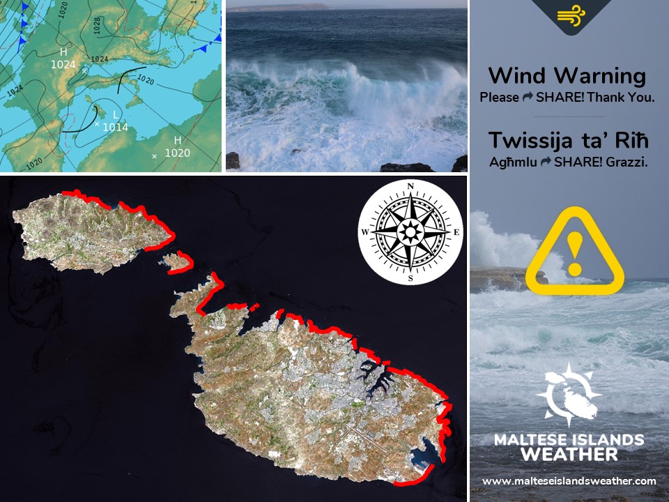
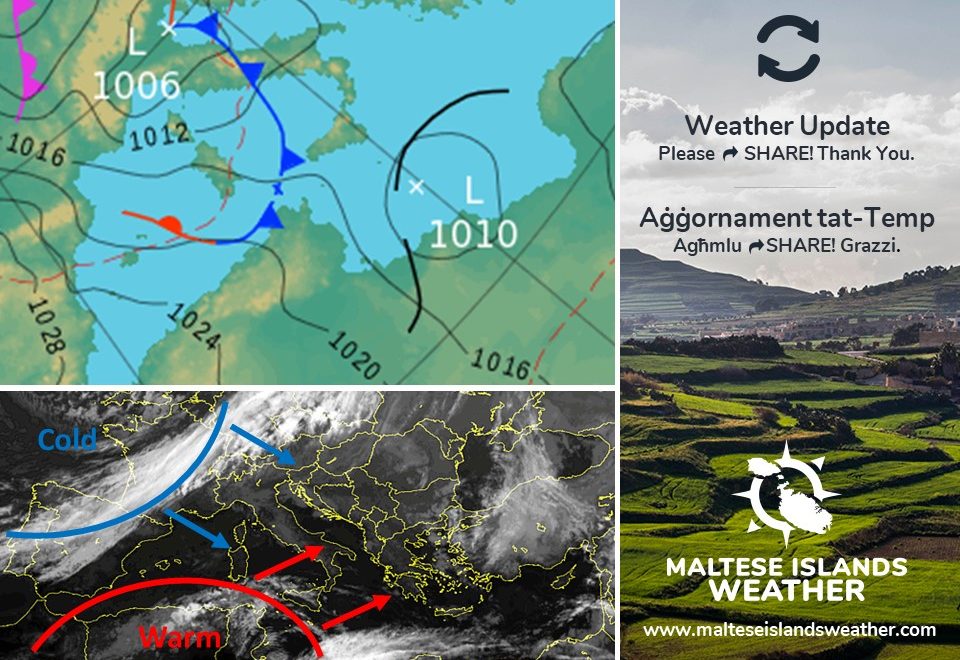
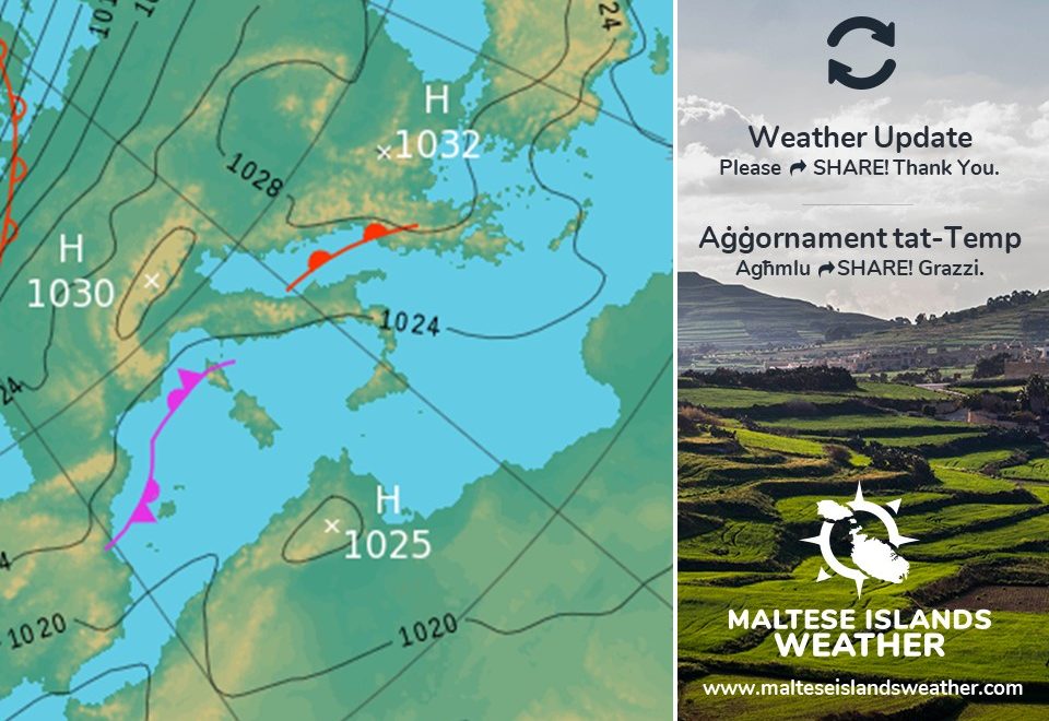
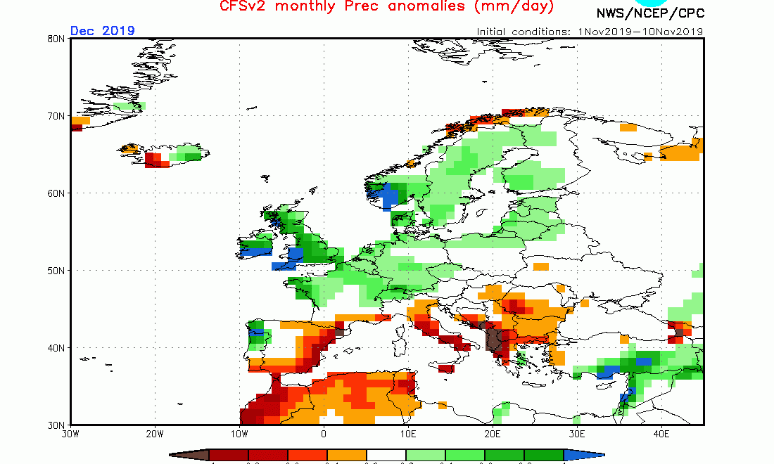
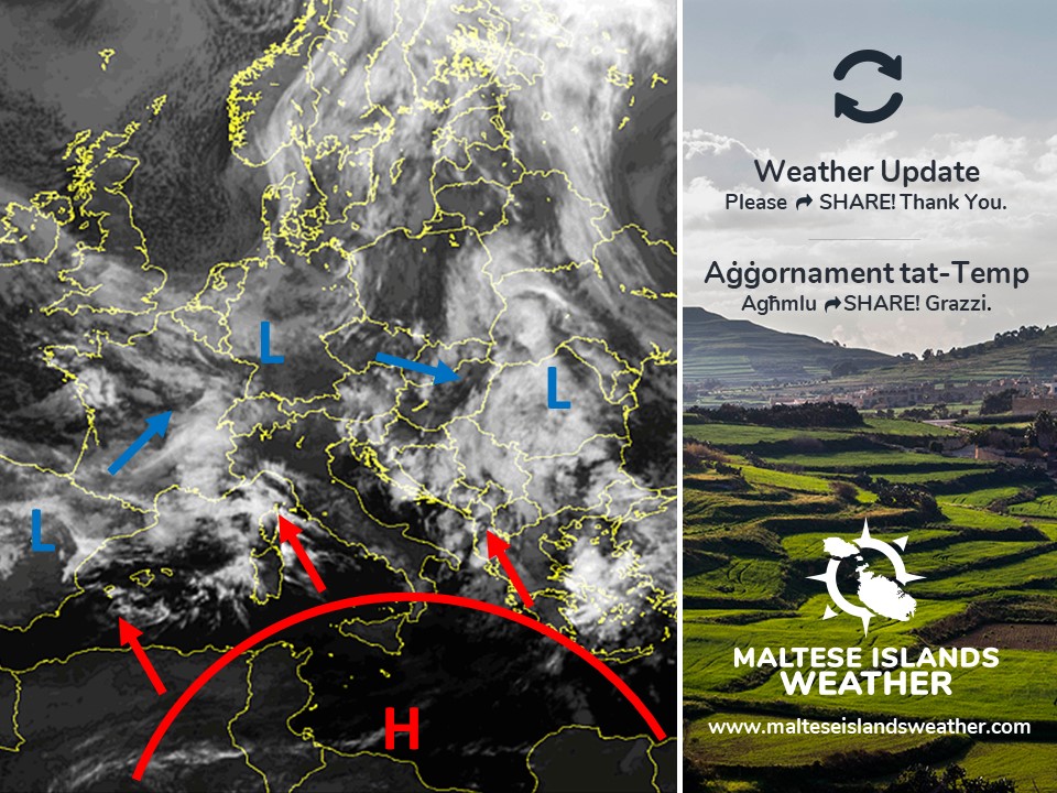
A low pressure system is present over the western Mediterranean. Meanwhile, a ridge of high pressure cover the eastern Mediterranean. This will cause a strong East wind to affect the area around the Maltese Islands. The wind will not be extremely strong, but taking the necessary precautions is helpful. This wind warning is valid from 03:00 on Wednesday 04/12 till 00:00 on Thursday 05/12. The details below describe how the situation will be developing over this time period.


Wednesday 04/12

03:00 to 06:00 – East Force 5/6 to 6/7

06:00 to 09:00 – East Force 6/7

09:00 to 12:00 – East Force 6/7

12:00 to 15:00 – East Force 6/7 to 7/8

15:00 to 18:00 – East Force 7/8

18:00 to 21:00 – East Force 7/8 to 6/7

21:00 to 00:00 – East Force 6/7 to 5/6


The peak gusts will blow across the Maltese Islands in the evening on Wednesday 04/12, and could reach Force 8 in exposed areas. The wind will decrease rapidly to become Force 1/2 by dawn on Thursday 05/12.

The sea will be rough to very rough, with wave heights of up to 7 metres in peak gusts. The swell will be low from the Northeast. The map shows the length of coastline most exposed to this strong wind.


Sistema ta’ pressjoni baxxa tinsab fuq il-punent tal-Mediterran. Sadattant, firxa ta’ pressjoni għolja qed tgħatti l-lvant tal-Mediterran. Din se twassal biex riħ qawwi mill-Lvant jaffetwa r-reġjun tal-Gżejjer Maltin. Ir-riħ mhux se jkun qawwi ħafna, imma l-prekawzzjonijiet meħtieġa għandhom jittieħdu xorta waħda. Din it-twissija ta’ riħ qawwi tkun fis-seħħ minn 03:00 ta’ l-Erbgħa 04/12 sa 00:00 tal-Ħamis 05/12. Id-dettalji ta’ hawn taħt juru kif se tiżviluppa s-sitwazzjoni matul dan il-ħin.


L-Erbgħa 04/12

03:00 sa 06:00 – Lvant Forza 5/6 għal 6/7

06:00 sa 09:00 – Lvant Forza 6/7

09:00 sa 12:00 – Lvant Forza 6/7

12:00 sa 15:00 – Lvant Forza 6/7 għal 7/8

15:00 sa 18:00 – Lvant Forza 7/8

18:00 sa 21:00 – Lvant Forza 7/8 għal 6/7

21:00 sa 00:00 – Lvant Forza 6/7 għal 5/6


Il-buffuri l-aktar qawwija mistennija filgħaxija ta’ l-Erbgħa 04/12, u kapaċi jilħqu Forza 8 f’postijiet esposti. Ir-riħ jonqos malajr u jsir Forza 1/2 sa sbieħ il-Ħamis 05/12.

Il-baħar se ikun imqalleb għal imqalleb ħafna, b’mewġ għoli 7 metri fl-aktar buffuri qawwija. L-imbatt se jkun baxx mill-Grigal. Il-mappa tindika l-kosta l-aktar esposta għal dan ir-riħ.

Updates

A dry December / Diċembru ta’ nixfa

The past three months were all characterised by wetter than average weather. As of the end of November, we were 81.3 mm ahead of the 232.4 mm we normally receive from September 1st till November 30th. This is set to change, however, as the weather is set to turn drier this month. The consistent presence of high pressure from over north Africa will prevent low pressure systems from reaching us on most days. The few low pressure systems that do reach us are not expected to be intense. As a result, rainfall should not be plentiful this month. With a climate-average of 109.7 mm, December is normally the wettest month of the year. It will certainly not be the case this time round.

L-aħħar tlett xhur kienu kkaratteriżżati minn temp aktar imxarrab minn normal. Sa l-aħħar ta’ Novembru, konna rċivejna 81.3 mm aktar minn 232.4 mm, l-ammont li ssoltu nirċievu minn l-1 ta’ Settembru sa 30 ta’ Novembru. Dan se jinbidel, pero, hekk kif it-temp għandu jieħu xejra differenti dan ix-xahar. Il-preżenza konsistenti ta’ pressjoni għolja minn l-Afrika ta’ fuq se tkun qed tipprevjeni ħafna sistemi ta’ pressjoni baxxa minn li jilħquna. Il-ftit sistemi ta’ pressjoni baxxa li se jilħquna mhux mistennija jkunu intensi. Għalhekk, ix-xita dan ix-xahar ma għandiex tkun abbundanti https://southafrica-ed.com/kamagra-in-south-africa/. B’medja klimatika ta’ 109.7 mm, Diċembru huwa normalment l-aktar xahar imxarrab tas-sena. Dan żgur mhux se jkun il-każ din is-sena.

Updates

This week: Stable weather to remain

The stability that has characterised our weather for much of last week will continue uninterrupted this week. With the exception of Monday 02/12 and Wednesday 04/12, when a partly to variably cloudy sky is expected, the sun will shine brightly over the Maltese Islands. Temperatures will be above-average throughout this week. Maximum temperatures will range from 20 C to 24 C. Minimum temperatures will vary from 13 C to 17 C. The wind will be mainly moderate. It will be strong at times, particularly on Wednesday 04/12. The wind direction will fluctuate greatly this week. It should blow from the Southeast to East till midweek, before veering West to Northwest from then on. This is all the result of an anticyclone over the central Mediterranean. No significant rainfall is expected this week. Processions planned for the feast of the Immaculate Conception on Sunday 08/12 will be able to go ahead as planned. Weather on the day will be partly cloudy with a 20 C high, 13 C low and a moderate wind from the Northwest.

Updates

A late Indian Summer / Is-Sajf ta’ San Martin ġie tard

As we’ve been saying for the past few days, the Maltese Islands are in for a lengthy period of warmer than average temperatures and dry weather. Maximum temperatures will be above 20 C till well into the first week of December. No rain is expected till then either. Future maps may reveal that this period of fine weather could last even longer. It’s now almost certain that what we are experiencing a late Indian Summer. An omega blocking pattern appears to have established itself across much of the Mediterranean region. A blocking pattern in meteorology is a large-scale and nearly stationary high pressure system. This blocking pattern, or anticyclone, blocks incoming low pressure systems. In our case, low pressure systems which normally approach us from the west will be deviated further north towards the UK and Scandinavia, as shown on the chart. These blocks remain in place for several days or even weeks, causing the areas affected by them to have the same kind of weather for an extended period of time. In our case, we will continue experiencing these very stable conditions. for a longer period of time than was initially anticipated. This spell of bright sunshine and warm temperatures will continue into December. The wind will be moderate at times strong, however. Very little rain is to be expected until then. In the northern hemisphere, this is referred to as an Indian Summer, or locally, as is-Sajf ta’ San Martin. This year, it has come very late. It is wise to know, however, that a blocking pattern usually ends abruptly with a major rainfall event.

Kif ilna ngħidu għal dawn l-aħħar jiem, il-Gżejjer Maltin deħlin għal perjodu twil ta’ temperaturi ogħla mill-medja u nixfa. It-temperaturi massimi se jkun ogħla minn 20 C sa minn ta’ l-anqas l-ewwel ġimgħa ta’ Diċembru. Mhux qed nistennew xita sa dakinhar anqas. Mapep futuri jistgħu jindikaw li dan il-perjodu ta’ temp bnazzi jaf idum ferm aktar minn kemm kien mistenni. Issa ninsabu ċerti li dak li qed nesperjenzaw huwa Sajf ta’ San Martin li ġie tard. Arja bi pressjoni għolja. ġiet stabbilita fuq ir-reġjun tal-Mediterran. Din l-arja bi pressjoni għolja normalment tkun mifruxa fuq medda kbira u bilkemm tiċċaqlaq. Din l-arja bi pressjoni għolja, jew antiċiklun, tipprevjeni sistemi ta’ maltemp minn li jilħquna. Fil-każ tagħna, maltemp dieħel mill-punent jiġi devjat lejn it-tramuntana, kif indikat fuq il-mappa. Antiċiklun bħal dan jaf iżomm postu għal jiem jew saħansitra ġimgħat sħaħ, u b’hekk iwassal biex l-inħawi li jkunu affetwati minnu jesperjenzaw temp stabbli għal perjodu twil. Fil-każ tagħna, se nibqgħu ngawdu minn bnazzi għal żmien ferm itwal minn kemm konna qed nistennew għal-ewwel. Dan il-perjodu ta’ bnazzi mistenni li jibqa sejjer f’Diċembru. Ir-riħ se jkun moderat għal-qawwi, pero. Minħabba dan, ftit li xejn se tagħmel xita. Fl-emisfera ta’ fuq, dan il-perjodu twil ta’ bnazzi jisejjaħ Indian Summer. F’Malta nafuh bħala s-Sajf ta’ San Martin. Din is-sena, dan ġie tard ħafna. Hu tajjeb pero, li żżommu f’moħħkom li dan normalment jiġi fi tmiemu b’episodju ta’ xita qawwija.

Updates

A long dry spell? / Waqfa twila mix-xita?

A weak ridge of high pressure over the central Mediterranean is expected to persist, according to latest weather charts. This will prevent any low pressure systems from penetrating our region, thus leading to an indefinite spell of dry weather. No more rain is expected till the end of this month. The dry weather may also prevail through the first week of December. Temperatures will remain warmer than average into December, with 19 C to 22 C highs and 13 C to 16 C lows. Some strong winds are possible on some days, however. Updates will be issued well in advance any of these.

Firxa dgħajfa ta’ pressjoni għolja fuq iċ-ċentru tal-Mediterran mistennija tippersisti, skont l-aħħar mapep tat-temp. Din se tipprevjeni sistemi ta’ pressjoni baxxa minn li jilħquna, u għalhekk se twassal għal waqfa indefinita mix-xita. Mhux qed nistennew aktar xita sa l-aħħar ta’ dan ix-xahar. Jista jkun ukoll li t-temp niexef jiba għaddej tul l-ewwel ġimgħa ta’ Diċembru, bl-ogħla ta’ 19 C sa 22 C u l-anqas ta’ 13 C sa 16 C. Xi jiem mirjieħa huma possibli, pero. Jekk ikun il-każ, tiġu nfurmati permezz ta’ aġġornamenti.