Updates

For the latest updates related to the weather in the Maltese Islands. So keep yourself updated by visiting this page frequently or like our Facebook page.

Updates

Calmer and warmer from tomorrow / Aktar kalm u sħun minn għada

An area of high pressure over north Africa will extend a ridge of high pressure towards the central Mediterranean, heralding the start of a spell of fine weather. Starting on Tuesday 26/11, the weather will be mainly sunny or partly cloudy on most days. Maximum temperatures will be a warm 19 C to 21 C. Minimum temperatures will be a milder 13 C to 15 C. The wind will be mainly light to moderate from the West. We may be in for a lengthy break from the rain.

Roqgħa ta’ pressjoni għolja fuq l-Afrika ta’ fuq se testendi firxa lejn iċ-ċentru tal-Mediterran, biex b’hekk tagħti bidu għal perjodu ta’ temp sabiħ. Minn nhar it-Tlieta 26/11, it-temp se jibda jkun il-biċċa l-kbira xemxi jew ftit imsaħħab. L-ogħla temperatura se tkun waħda sħuna, b’valuri ta’ 19 C sa 21 C. L-anqas temperatura se tkun ta’ 13 C sa 15 C. Wieħed għandu jistenna wkoll riħ ħafif għal moderat mill-Punent. Jista jkun li se nesperjenzaw waqfa daqsxejn fit-tul mix-xita.

Updates

STRONG WIND WARNING / TWISSIJA TA’ RIĦ QAWWI

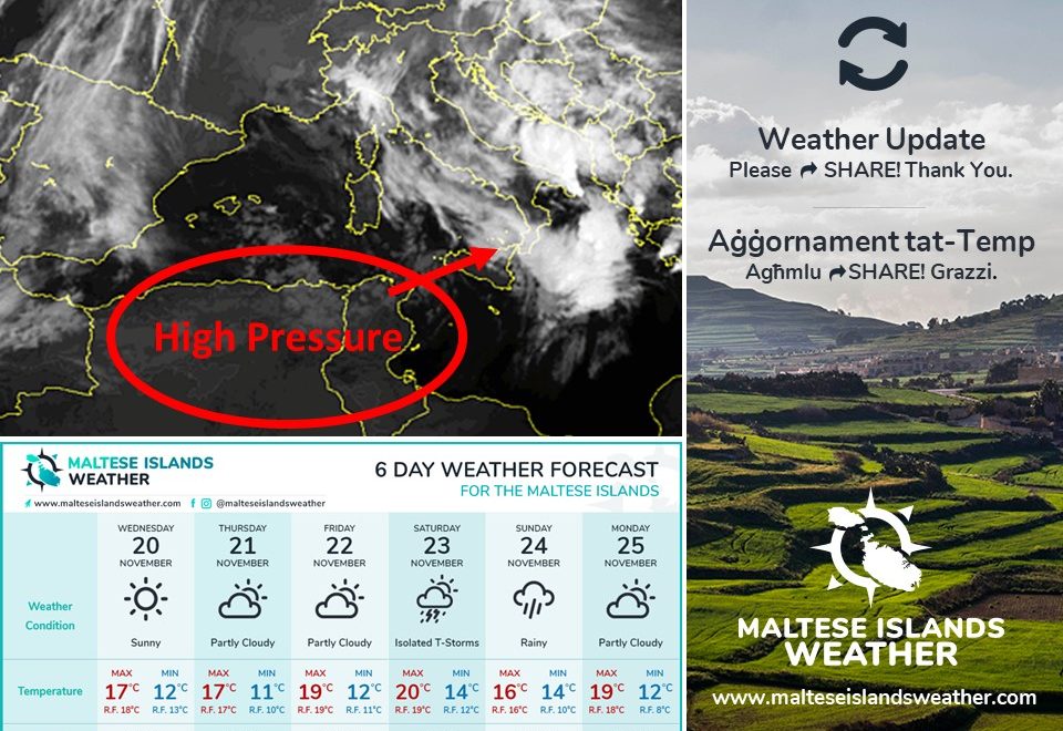
An intense low pressure system is traversing the central Mediterranean. Its centre will be to our east by later in the day on Monday 25/11. Meanwhile, a ridge of high pressure will develop over the western Mediterranean. This will cause a strong West wind to affect the area around the Maltese Islands. The wind will not be extremely strong, but taking the necessary precautions is helpful. This wind warning is valid from 09:00 till midnight on Monday 25/11. The details below describe how the situation will be developing over this time period.


Monday 25/11

09:00 to 12:00 – West Force 5/6 to 6/7

12:00 to 15:00 – West Force 6/7

15:00 to 18:00 – West Force 6/7 at times 8

18:00 to 21:00 – West Force 6/7 at times 8

21:00 to 00:00 – West Force 6/7 to 5/6


The peak gusts will blow across the Maltese Islands in the late afternoon and early evening on Monday 25/11, and could reach Force 8 on exposed areas. The wind will become Northwest and decrease gradually during the day on Tuesday 26/11, to become Force 3/4 by evening.

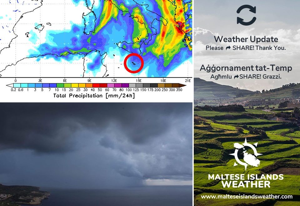
The sea will be rough to very rough, with wave heights of up to 7 metres in peak gusts. The swell will be low from a West direction. The map shows the length of coastline most exposed to this strong wind.


Sistema ta’ pressjoni baxxa intensa għaddejha minn fuq iċ-ċentru tal-Mediterran. Iċ-ċentru tagħha se jsib ruħu lejn il-lvant tal-Gżejjer Maltin aktar tard it-Tnejn 25/11. Sadattant, firxa ta’ pressjoni għolja se tiżviluppa fuq il-punent tal-Mediterran. Din is-sitwazzjoni se twassal għal riħ qawwi mill-Punent madwar il-Gżejjer Maltin. Ir-riħ mhux se jkun qawwi ħafna, imma l-prekawzzjonijiet meħtieġa għandhom jittieħdu xorta waħda. Din it-twissija ta’ riħ qawi tkun fis-seħħ minn 09:00 sa nofsillejl tat-Tnejn 25/11. Id-dettalji ta’ hawn taħt juru kif se tiżviluppa s-sitwazzjoni matul dan il-ħin.


It-Tnejn 25/11

09:00 sa 12:00 – Punent Forza 5/6 għal 6/7

12:00 sa 15:00 – Punent Forza 6/7

15:00 sa 18:00 – Punent Forza 6/7 kultant 8

18:00 sa 21:00 – Punent Forza 6/7 kultant 8

21:00 sa 00:00 – Punent Forza 6/7 għal 5/6


Il-buffuri l-aktar qawwija mistennija tard wara nofsinhar u kmieni filgħaxija tat-Tnejn 25/11, u kapaċi jilħqu Forza 8 f’postijiet esposti. Ir-riħ idur Majjistral u jonqos gradwalment it-Tlieta 26/11, u jsir Forza 3/4 sa filgħaxija.

Il-baħar se ikun imqalleb għal imqalleb ħafna, b’mewġ għoli 7 metri fl-aktar buffuri qawwija. L-imbatt se jkun baxx mill-Punent. Il-mappa tindika l-kosta l-aktar esposta għal dan ir-riħ.

Updates

This week: Warmer weather ahead

With the exception of Monday 25/11, this week will be fairly stable across the Maltese Islands. A low pressure system traversing the central Mediterranean will bring further showers which will be heavy, thundery and with hail at times to the Maltese Islands on Monday polska-ed.com. The Westerly wind will reach Force 6/7. With a 16 C high and 13 C low, Monday will be this week’s coldest day. From Tuesday 26/11 onward, high pressure over north Africa will extend towards the central Mediterranean. This will bring a spell of fine weather to our shores. The skies will be mainly sunny or partly cloudy much of the time. The wind, predominantly from the West, will be mainly light to moderate. Daytime highs will climb to a warmer 19 C / 20 C. Nighttime lows will be at a mild 14 C / 15 C. No significant rainfall is anticipated from Tuesday till Sunday 01/12.

Updates

THUNDERSTORM WARNING / TWISSIJA TA’ MALTEMPATA

After the latest model update, we have decided to issue a weather warning. The main threat appears to be from a squall line capable of producing a large amount of precipitation in a very short period of time. This thunderstorm warning will be valid from 03:00 till 15:00 on Sunday 24/11, unless otherwise indicated.

An intense low pressure system will be traversing the western Mediterranean over the course of this weekend. When over the Tyrrhenian Sea, a front associated with this system will move across the central Mediterranean. It will mainly affect Sicily, but could extend south enough to also affect the Maltese Islands. The warm and humid air locally will clash with the cold air behind the front, activating the front. A squall line may develop along the front. A squall line is an elongated line of thunderstorms that tends to form along or ahead of a front. If this does affect the Maltese Islands, expect rain which will be heavy, thundery and with hail at times. It is most likely early in the morning on Sunday 24/11. Total rainfall may reach 50 mm in hardest hit localities. Whilst the warning for this particular thunderstorm will be in effect from 03:00 till 15:00 on Sunday 24/11, heavy rain showers are possible at any time from late on Saturday 23/11 till early on Monday 25/11.

Apart from heavy rainfall, the Maltese Islands will also experience some strong winds. At its strongest, the wind could reach Force 6/7 at times (from the South on Saturday 23/11, from the West on Sunday 24/11 and from the West Northwest on Monday 25/11).


Wara l-aħħar aġġornament tal-mapep, iddeċidejna li noħorġu twissija. Jidher li l-aktar ħaġa li hija possibbli se tkun ammont ta’ xita f’ħin qasir minn ‘squall line’. It-twissija ta’ maltempata se tkun fis-seħħ minn 03:00 sa 15:00 tal-Ħadd 24/11, sakemm mhux indikat mod ieħor.

Sistema ta’ pressjoni baxxa intensa se tkun qed tgħaddi minn fuq il-punent tal-Mediterran tul tmiem il-ġimgħa. X’ħin din se tkun fuq il-baħar Tirren, front assoċjat ma’ din l-istess sistema se jgħaddi minn fuq iċ-ċentru tal-Mediterran. Se jaffetwa b’mod partikolari lil Sqallija, imma jaf jestendi biżejjed l-isfel li jmiss lilna wkoll. L-arja sħuna u umda li hawn madwarna għandha taħbat ma’ arja kiesħa abbinata ma’ dan il-front, biex b’hekk tibda l-maltemp. Jidher li se tkun qed tiżviluppa ‘squall line’ ma’ dan il-front. ‘Squall line’ hija linja ta’ maltempati bir-ragħad li tiżviluppa ma’ jew qabel front. Jekk din tmiss lill-Gżejjer Maltin, stennew xita li tkun qawwija, bir-ragħad u bis-silġ kultant. Jidher li ċ-ċans huwa ogħla kmieni l-Ħadd 24/11. It-total ta’ xita jaf jilħaq 50 mm fl-aktar lokalitajiet milquta. Minkejja li t-twissija għal din il-maltempata tkun fis-seħħ minn 03:00 sa 15:00 tal-Ħadd 24/11, ħalbiet tax-xita qawwijin huma possibbli minn ħin għal-ieħor minn tard is-Sibt 23/11 sa kmieni t-Tnejn 25/11.

Apparti x-xita qawwija, il-Gżejjer Maltin se jintlaqtu wkoll minn riħ qawwi. Fl-aqwa tiegħu, dan jista jilħaq Forza 6/7 kultant (minn Nofsinhar is-Sibt 23/11, mill-Punent il-Ħadd 24/11 u mill-Punent Majjistru t-Tnejn 25/11).

Updates

A wet weekend ahead / Tmiem il-ġimgħa ta’ xita

An intense low pressure system will be traversing the central Mediterranean during the next couple of days or so. This means that a wet and windy weekend is on the cards for the Maltese Islands. The system’s effects on the Maltese Islands will be felt from Saturday 23/11 through to Monday 25/11. Saturday 23/11 will see a strong wind from the South Southeast. There will also be a number of showers, especially later in the day. These should be heavy, thundery and with hail at times. Sunday 24/11 will be characterised by a strong wind which veers from the South Southeast to Northwest over the course of the day. It may reach gale-force late in the day. Sunday 24/11 will be the wettest. Rain showers which will be heavy, thundery and with hail at times are expected throughout the course of the day. Monday 25/11 will be the third day of stormy weather. The Northwest wind will gradually back North during the day, whilst decreasing slowly to become moderate by evening. There will be further showers, especially early in the day. These should be heavy, thundery and with hail at times. Temperatures this weekend will range from 16 C to 19 C as highs, and from 13 C to 15 C as lows. Total rainfall is expected to be high, with the national average varying anywhere from 25 mm to 50 mm.

Sistema ta’ pressjoni baxxa intensa se taqsam iċ-ċentru tal-Mediterran fil-jiem li ġejjin. Din is-sistema għandha taffetwana minn nhar is-Sibt 23/11 sat-Tnejn 25/11. Is-Sibt 23/11 mistenni riħ qawwi minn Nofsinhar ix-Xlokk. Se jkun hemm ukoll numru ta’ ħalbiet tax-xita, speċjalment aktar tard mal-jum. Dawn se jkunu qawwijin, bir-ragħad u bis-silġ kultant. Il-Ħadd 24/11 tkun il-qofol tal-maltemp. Se tkun ikkarateriżżata minn riħ qawwi li jdur bilmod minn Nofsinhar ix-Xlokk għal Majjistral. Jista jilħaq il-qawwa ta’ riefnu tard mal-jum. Il-Ħadd 24/11 se jkun l-aktar jum bix-xita. Nistennew ħalbiet tax-xita li se jkunu qawwijin, bir-ragħad u bis-silġ kultant matul il-jum kollu. It-Tnejn 25/11 se jkun it-tielet jum ta’ maltemp. Ir-riħ mill-Majjistral se jdur ftit u jsir Tramuntana matul il-jum, filwaqt li jonqos daqsxejn u jsir moderat sa filgħaxija. Se jkollna diversi ħalbiet tax-xita, speċjalment kmieni fil-jum. Dawn jibqgħu jkunu qawwijin, bir-ragħad u bis-silġ kultant. It-temperaturi fi tmiem il-ġimgħa se jvarjaw bejn 16 C u 19 C bħala l-ogħla u 13 C sa 15 C bħala l-anqas. It-total ta’ xita mistenni li jkun sostanzzjali, bit-total nazzjonali jkun ivarja minn 25 mm sa 50 mm.

Updates

Cold night ahead / Ġej lejl kiesaħ

A cold night lies ahead for the Maltese Islands. In fact, it will be the coldest since February. This is due to clear skies and light winds under anticyclonic conditions. In the cooler months, calm and clear conditions allow heat to be lost from the surface of the Earth to space by radiation. This allows temperatures to fall steadily. As the stable air near to the ground cools, it can become saturated. Saturation leads to the development of mist and fog. For this reason, we urge you to express caution on the road. Patches of dense fog are possible across inland areas. Temperatures will fall to around 10 C tonight, possibly lower across inland areas. Coastal areas tend to be warmer than inland areas, since the warm sea moderates temperatures there.

Lestu għal lejl kiesaħ. Filfatt, dan jista jkun l-aktar lejl kiesaħ sa minn Frar li għadda. Dan minħabba sema ċar u riħ ħafif ħafna taħt kundizzjonijiet antiċikloniċi. Fix-xhur xitwin, sema ċar u riħ ħafif ħafna jgħin biex is-sħana qrib l-art tintilef lejn l-ispazju. Din twassal biex it-temperatura tonqos sew. Hekk kif l-arja stabbli qrib l-art tiksaħ, din kapaċi tilħaq stat ta’ saturazzjoni. Arja saturata twassal għal iżvilupp ta’ ċpar. Għal din ir-raġuni, se navżawkom biex tkun ferm aktar kawtela fit-triq. Irqajja ta’ ċpar dens jista jifforma f’inħawi lejn iċ-ċentru tal-gżejjer. It-temperaturi billejl għandhom jinżlu sa 10 C, possibilment anqas f’inħawi ċentrali. Inħawi tul il-kosta għandhom tendenza li jkunu ferm anqas kesħin minn inħawi entrali, minħabba l-effett tal-baħar.

Updates

Calm before more bad weather / Kalma qabel aktar maltemp

After a very wet day for parts of the Maltese Islands, it is time for a brief spell of calm. An area of high pressure over north Africa will extend a ridge towards the central Mediterranean. This means two to three days of relative calm for the Maltese Islands. The Northwest to Southwest wind will die down to Force 2/3. The sky will be variably cloudy much of the time. No significant rainfall is expected on Wednesday 20/11, Thursday 21/11 and Friday 22/11. Rainy weather should return on Saturday 23/11 and Sunday 24/11. The wind will pick up then as well. Further details in a separate update.

Wara ġurnata ta’ xita għal partijiet tal-Gżejjer Maltin, wasal iż-żmien għal waqfa qasira ta’ kalma. Arja bi pressjoni għolja fuq l-Afrika ta’ fuq se testendi firxa lejn iċ-ċentru tal-Mediterran. Dan ifisser jumejn jew tlieta ta’ kalma għal Gżejjer Maltin. Ir-riħ mill-Majjistral għal-Lbiċ se jonqos għal Forza 2/3. Is-sema se jkun varjabbilment imsaħħab ħafna mill-ħin. Mhux qed nistennew xita sinifikanti nhar il-Erbgħa 20/11, il-Ħamis 21/11 u l-Ġimgħa 22/11. Ix-xita mistennija tirritorna nhar is-Sibt 23/11 u l-Ħad 24/11. Ir-riħ se jerġa jżid ukoll dakinhar. Aktar dettalji dwar dan f’aġġornament separat.

Updates

The edge of a cold front / It-tarf ta’ front kiesaħ

The edge of a cold front will be touching the central Mediterranean on Tuesday 19/11. This cold front is associated with a low pressure system over the Gulf of Genoa. The Southerly wind will maintain the flow of moist and warm air towards the central Mediterranean. The cold front will bring cold air towards our region. The contrast between the two will lead to the development of an area of isolated showers around the Maltese Islands. Some of these could pass over parts of the Maltese Islands. Some isolated showers may be briefly heavy, thundery and with hail at times. No severe weather is being anticipated. The chance of rain will be highest from 06:00 until 18:00 on Tuesday 19/11. Total rainfall should not exceed 10 mm.

It-tarf ta’ front kiesaħ se jgħaddi minn fuq iċ-ċentru tal-Mediterran nhar it-Tlieta 19/11. Dan it-tarf kiesaħ abbinat ma’ sistema ta’ pressjoni baxxa fuq il-Golf ta’ Genoa. Ir-riħ minn Nofsinhar se jġib miegħu arja sħuna u umda lejn iċ-entru tal-Mediterran. Il-front kiesaħ se jġib miegħu arja kiesħa lejn ir-reġjun tagħna. Il-kuntrast ta’ bejn it-tnejn se jwassal għal iżvilupp ta’ massa ta’ ħalbiet iżolati tax-xita madwar il-Gżejjer Maltin. Xi wħud minn dawn jistgħu jgħaddu minn fuq xi nħawi tal-Gżejjer Maltin. Xi ħalbiet iżolati tax-xita jistgħu jkunu qawwijin, bir-ragħad u bis-silġ għal xi ħin kultant. Mhux qed nistennew maltemp qawwi. Iċ-ċans ta’ xita se jkun l-ogħla minn 06:00 sa 18:00 tat-Tlieta 19/11. It-total ta’ xita ma għandux jaqbeż 10 mm.

Updates

This week: A mix of weather conditions

The coming week will be a true mix of weather conditions for the Maltese Islands. From Monday 18/11 through to Friday 22/11, the Maltese Islands will be influenced by alternating high and low pressure systems. Monday will see plenty of sunshine. Tuesday, on the other hand, will be a fairly wet day. This is due to troughs of low pressure that will traverse the central Mediterranean on the day. A ridge of high pressure will ensure the return of fair weather to our shores on Wednesday and Thursday. Finally, an intense low pressure system will cover the Maltese Islands by the weekend, heralding the start of a potential spell of bad weather. The wettest days this week will be Tuesday and Sunday. Both should see heavy rain. Maximum temperatures will be stable through the week, with values ranging from 17 C to 19 C. Minimum temperatures will be more variable, with values varying from 10 C to 14 C. Wind speed and direction will fluctuate considerably. It will be strongest on Tuesday and Sunday.

Updates

No more 20 C + highs? Daqshekk 20 C + matul il-jum?

It seems that after today, the transition to winter will move onto the next level. Maximum temperatures are set to drop below 20 C for good. In the long-term, maximum temperatures will be at 17 C to 19 C. Lows will vary more. They will range from 11 C to 15 C. With regards to rainfall, we expect significant rainfall on several days. These are the 19th and sometime around the 24th/25th.

Jidher li wara llum, il-qalba għax-xitwa se timxi għal-istadju li jmiss. It-temperaturi massimi se jinżlu taħt l-20 C għal kollox. Fit-tul, l-ogħla temperaturi se tvarja minn 17 C sa 19 C. L-anqas temperatura se tkun aktar varjabbli. Mistennija tvarja minn 11 C sa 15 C. Fejn tidħol xita, qed nistennew ammonti sinifikanti f’numru ta’ jiem. Dawn se jkunu d-19 u xi żmien madwar l-24/25.