Updates

For the latest updates related to the weather in the Maltese Islands. So keep yourself updated by visiting this page frequently or like our Facebook page.

Updates

Calendar 2020 For Sale

The 2020 Calendar from Maltese Islands Weather is on sale at 15 euro (including postage). The calendar features a selection of twelve photographs taken by Maltese Islands Weather admin Andrea Muscat. The calendar consists of thirteen pages (front page + twelve months) libido-de.com/. It is in A3 (42 cm x 30 cm / 16.5″ x 11.8″) and is printed on the finest material. Just fill in the form below to secure your order. Your product will be posted by the end of November.

Calendar 2020

Il-Kalendarju 2020 minn Maltese Islands Weather jinsab għal bejgħ għal 15 euro (posta inkluża). Il-kalendarju fih sett ta’ 12-il ritratt meħuda minn Andrea Muscat, li jmexxi Maltese Islands Weather. Il-kalendarju jikkonsisti fi 13-il paġna (il-qoxra ta’ barra u tnax-il xahar). Huwa A3 (42cm x 30 cm / 16.5″ x 11.8″) u se jkun ippublikat fuq materjal mill-aqwa. Kemm timlew il-formola fil-link biex tagħmlu dan l-order. Il-prodott ikun mibgħut bil-posta sa l-aħħar ta’ Novembru.

Calendar 2020


Updates

This week: Fine at first; becoming stormy

The meteorological situation at the start of this week shall see high pressure continue to extend across much of the eastern and central Mediterranean. Low pressure will continue to dominate the western Mediterranean. The high pressure across the eastern and central Mediterranean will weaken over the course of this week. This will allow the low pressure over the western Mediterranean to move eastwards. Fine weather will prevail for the Maltese Islands throughout the first half of this week. Things will turn unstable on Thursday, as the low pressure inches closer. The sky will cloud up on Thursday 24/10. There will be showers over the weekend. The wettest day this week should be Sunday 27/10. The wind will be predominantly from the Southeast. It will be mainly light to moderate, but could become strong at times, especially on Thursday 24/10. Temperature will be fairly stable, with 24 C to 26 C highs and 19 C to 21 C lows.

Reports, Updates

Stable temperatures ahead / It-temperaturi se jibqgħu stabbli

Low pressure will persist over the western Mediterranean. Meanwhile, high pressure will prevail across the central and eastern Mediterranean. This will generate a flow of air from the south to southeast across our region. This will prevail for some days. The southerly wind will mean mild temperatures for the Maltese Islands till possibly the end of October. Temperatures will be above the average for this time of year. Maximum temperatures will hover around the 25 C mark, while lows will be of 19 C to 20 C.  Any precipitation will be in the form of isolated showers. No major rainfall events are being anticipated till the end of October.

Pressjoni baxxa se tippersisti lejn il-punent tal-Mediterran. Sadattant, pressjoni għolja se tkompli tkopri ċ-ċentru u lvant tal-Mediterran. Din se twassal għal riħ minn nofsinhar għal-xlokk. Dan se jippersisti għal numru ta’ jiem. Dan ir-riħ se jfisser temperaturi kemmxejn sħan għal Gżejjer Maltin possibilment sa l-aħħar ta’ Ottubru. It-temperaturi se jkunu ogħla mill-medja għal dan iż-żmien tas-sena. L-ogħla se jkunu ta’ 25 C, filwaqt li l-anqas se jvarjaw minn 19 C sa 20 C. Kwalunkwe xita se tkun fil-forma ta’ ħalbiet iżolati. Mhu qed nistennew l-ebda episodji ta’ xita severi sa l-aħħar ta’ Ottubru.

Updates

Isolated showers ahead / Ġejjin xi ħalbiet iżolati tax-xita

Cool air from the north will slide over the warm sea locally, creating a weak zone of instability over the central Mediterranean. This unstable air mass should affect the Maltese Islands from late morning on Tuesday 15/10 till late morning on Wednesday 16/10. It should bring us some isolated showers possibly thundery at times. Total rainfall should not exceed 10 mm. The wind will be light from the South on Tuesday 15/10. It turns Northwest on Wednesday 16/10. The temperature will remain warm, with a 26 C / 27 C high and 19 C / 20 C low on both days. No severe weather is being anticipated.

Arja friska mit-tramuntana se tgħaddi minn fuq il-baħar sħun madwarna, u b’hekk mistennija tinħoloq żona dgħajfa ta’ instabbilta’. Din il-massa ta’ arja instabbli għandha taffetwa lill-Gżejjer Maltin minn tard filgħodu t-Tlieta 15/10 sa tard filgħodu l-Erbgħa 16/10. Din għandha ġġib magħha xi ħalbiet iżolati tax-xita li jistgħu jkunu bir-ragħad kultant. It-total ta’ xita ma għandux jaqbeż 10 mm. Ir-riħ se jkun ħafif minn Nofsinhar nhar it-Tlieta 15/10. Dan għandu jdur Majjistral l-Erbgħa 16/10. It-temperatura se tibqa sħuna, bl-ogħla ta’ 26 C / 27 C u l-anqas ta’ 19 C / 20 C fil-jumejn li huma. Mhux qed nistennew maltemp qawwi.

Updates

HEAVY RAIN WARNING / TWISSIJA TA’ XITA QAWWIJA

After the latest model update, we are issuing a weather warning. The main threat appears to be of heavy rainfall. The warning is valid from 13:00 till 23:00 on Monday 07/10 unless otherwise indicated.

As forecast yesterday, a week of instability lies ahead for the Maltese Islands. An incursion of cold air from the north will clash with the warm sea locally, leading to the development of a vigorous low pressure system over the central Mediterranean. A cold front associated with this low pressure system will move across the Maltese Islands on Monday 07/10. A band of rain will be associated with this cold front. A number of isolated thunderstorms should be embedded within. This band of rain is expected to produce a period of steady rainfall, which will be heavy and thundery at times. This should affect us mainly in the late afternoon or early evening. Isolated showers, possibly heavy at times, are possible at any time during the day. The rainfall should be widespread, and therefore, all of the Maltese Islands should receive a decent amount of precipitation. Luckily, atmospheric conditions above the Maltese Islands will not be favourable for large hail and funnels to form. Total rainfall amounts will range between 25 mm and 50 mm with higher amounts possible in localized areas. The weather situation will improve substantially by morning on Tuesday 08/10, with partly cloudy skies.


Wara l-aħħar aġġornament tal-mapep, iddeċidejna noħorġu twissija ta’ maltemp. Jidher li t-theddida se tkun l-aktar minn xita qawwija. Din it-twissija se tkun fis-seħħ minn 13:00 sa 23:00 tat-Tnejn 07/10, sakemm ma tkunx aġġornata.

Kif bassarna l-bieraħ, ġimgħa ta’ instabbilita’ hija mistennija fil-Gżejjer Maltin. Inkurzjoni ta’ arja kiesħa mit-tramuntana se toħloq kunflitt mal-baħar sħun ta’ madwarna. Din se twassal biex tinħoloq sistema ta’ pressjoni baxxa qawwija madwar iċ-ċentru tal-Mediterran. Front ta’ arja kiesħa assoċjat ma’ din is-sistema ta’ pressjoni baxxa se jgħaddi minn fuq il-Gżejjer Maltin it-Tnejn 07/10. Massa ta’ xita se tkun assoċjata ma’ dan il-front kiesaħ. Xi maltempati bir-ragħad iżolati għandhom jiffurmaw f’din. Din il-massa ta’ xita mistennija twassal għal perjodu ta’ xita kontinwa, li għandha tkun qawwija u bir-ragħad kultant. Din għandha taffetwana l-aktar tard wara nofsinhar jew filgħaxija. Ħalbiet iżolati tax-xita, li jistgħu jkunu qawwijin kultant, huma possibbli f’kwalunkwe ħin matul il-jum. Din ix-xita se tkun mifruxa, u għalhekk il-Gżejjer Maltin kollha għandhom jirċievu ammont sostanzzjali ta’ xita. Fortunatament, il-kundizzjonijiet atmosferiċi mhux se jiffavorixxu l-formazzjoni ta’ silġ kbir jew trombi. It-total ta’ xita għandu jvarja minn 25 mm sa 50 mm b’ammonti għola f’postijiet lokaliżżati. Is-sitwazzjoni tat-temp se taqleb għal aħjar sa filgħodu tat-Tlieta 08/10, b’sema ftit imsaħħab.


Updates

A month’s worth of rainfall in four days? / Xita ta’ xahar f’erbat’ijiem?

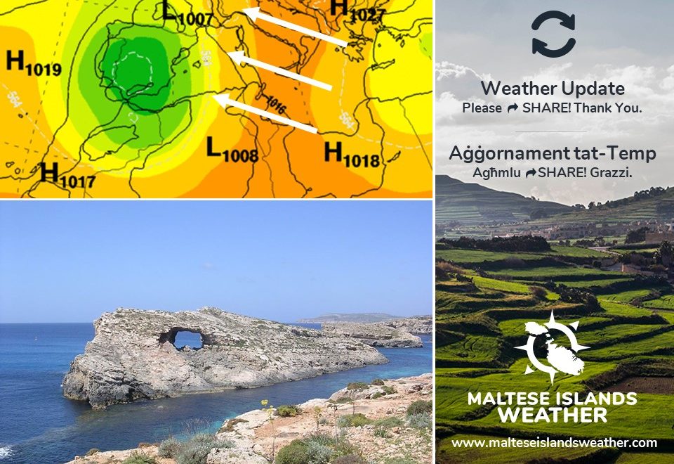
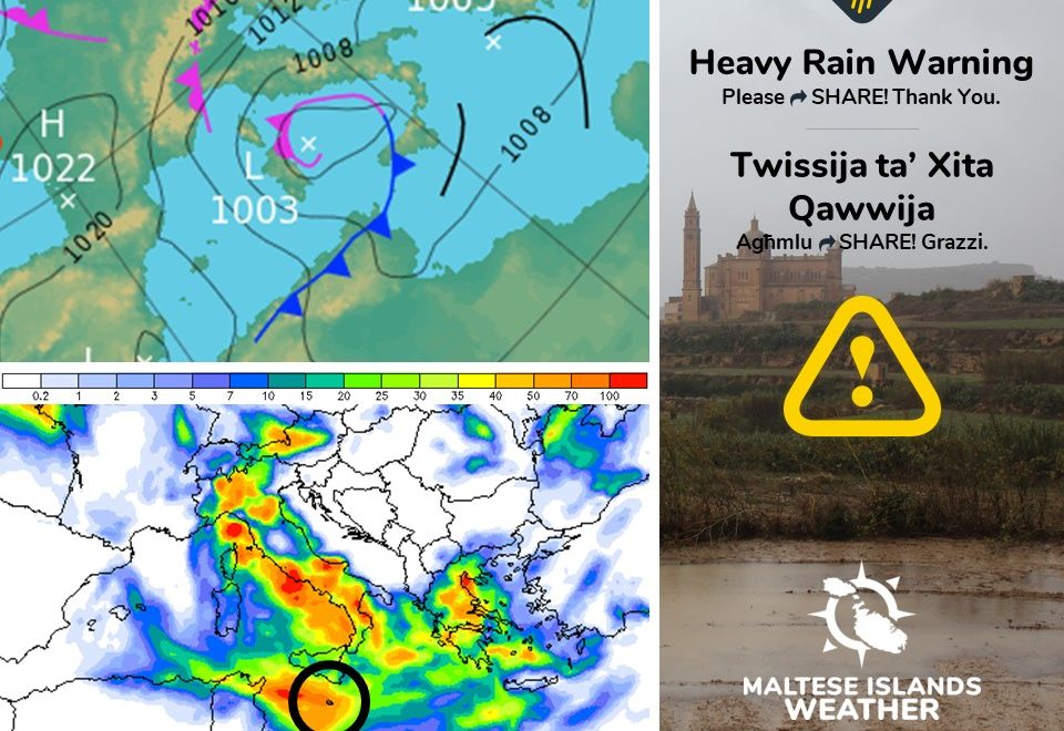
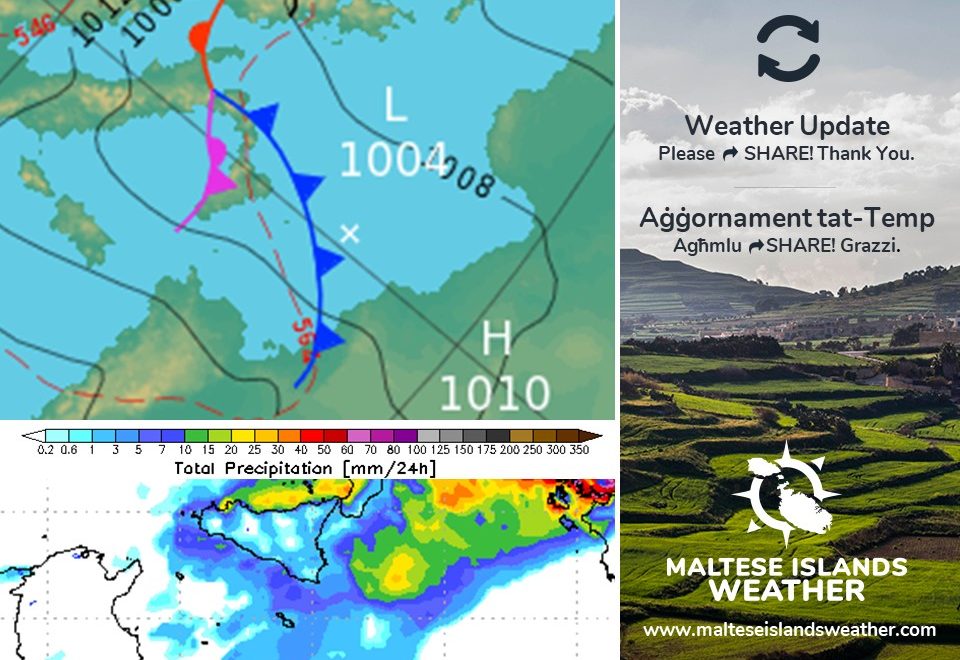
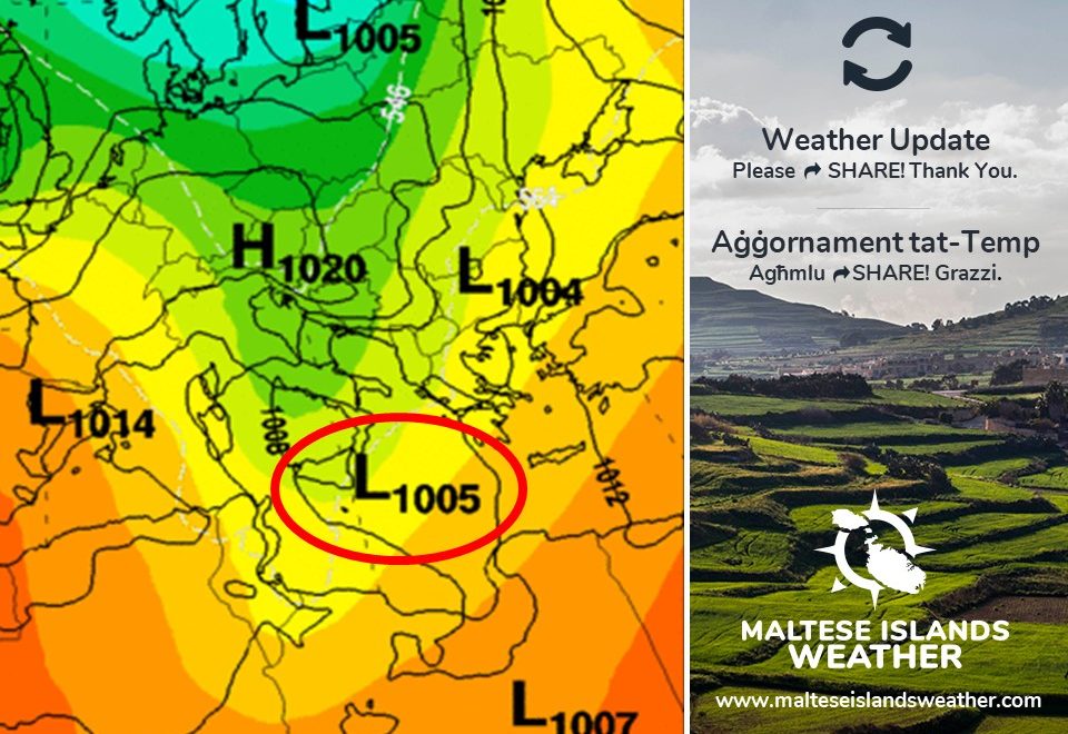
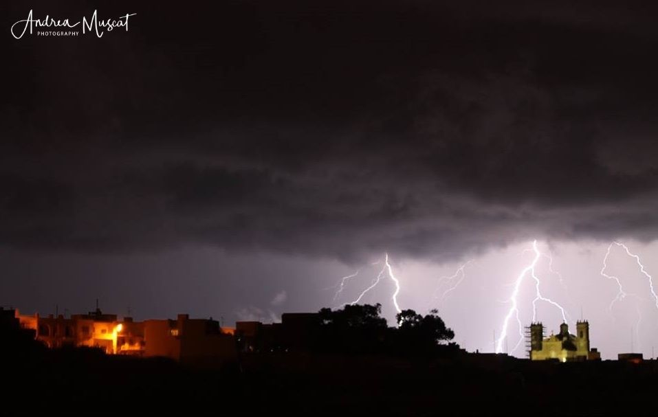
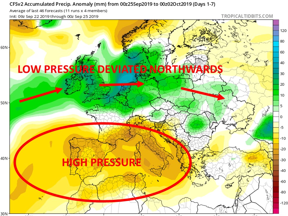
An incursion of cold air from over Scandinavia will clash with the warm sea locally in the coming week. This will lead to the development of a vigorous low pressure system across the central Mediterranean. This low pressure system will be almost stationary for at least four days, bringing a period of instability to the Maltese Islands. This should bring a long spell of dry weather to an end. Some parts of the Maltese Islands have not seen a decent shower for more than three weeks.

A mass of showers and thunderstorms will be moving around the central Mediterranean for up to four days. Showers are possible at any time from late morning on Monday 07/10 till late evening on Thursday 10/10. The bulk of the precipitation will fall at the following times:

  • From late afternoon till late at night on Monday 07/10
  • From late afternoon till late at night on Tuesday 08/10
  • Throughout the day on Wednesday 09/10
  • From late afternoon till late at night on Thursday 10/10

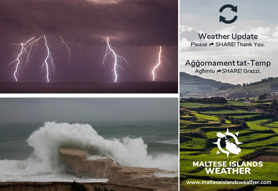
At the times indicated above, one is to expect showers or thunderstorms which will be heavy at times. Rainfall may be steady at times too. A month’s worth of precipitation, or more, could fall over the course of these four days. In a typical October, the Maltese Islands experience a total of 83.3 mm of precipitation.

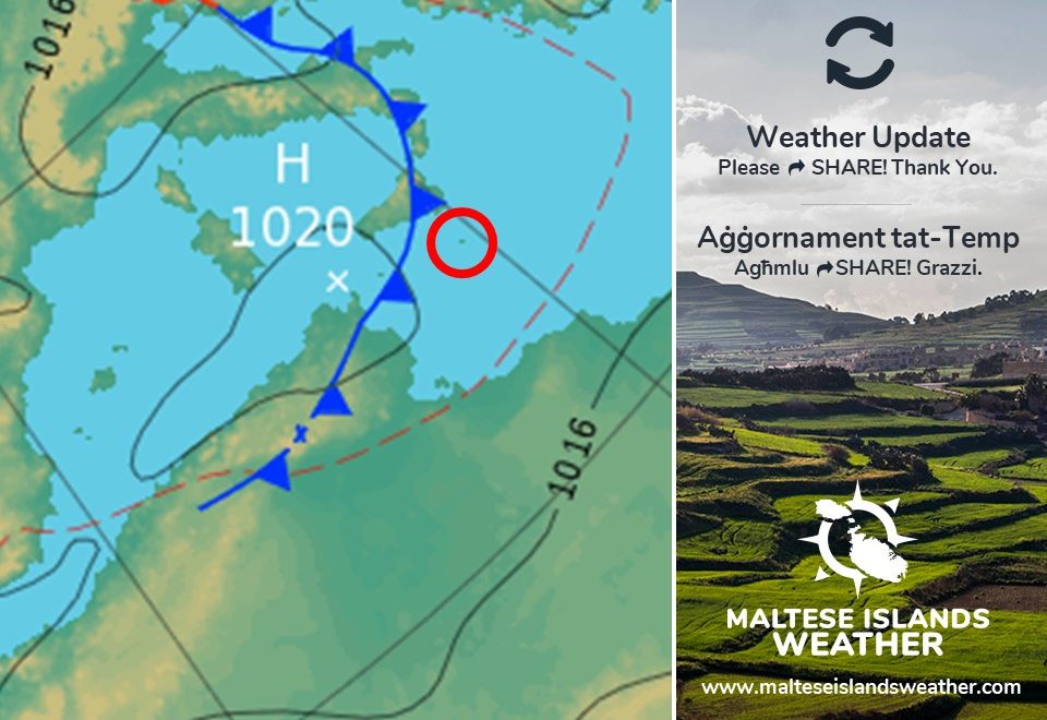
The wind will be strong (Force 5/6) from the West till late in the evening on Monday 07/10. It will then veer East and become strong (Force 6/7 to 5/6) again from the morning on Tuesday 08/10 till late at night on Thursday 10/10. Gusts may be stronger, particularly during potential thunderstorms.

The main threat will be heavy rainfall and strong winds. This weather is typical for the autumn months, and therefore, there is no need for alarm. We advise you to be cautious when driving. You should drive with caution and avoid areas known to flood. Also, we advise you not to do any swimming on these days, as the sea will be rough. There will also be dangerous currents around. Finally, we advise you not to leave your vehicles along coasts exposed to the strong wind.

Inkursjoni ta’ arja kiesħa minn fuq l-Iskandinavja se toħloq kunflitt mal-baħar sħun li għandna madwarna matul il-ġimgħa li ġejja. Dan se jwassal biex tiżviluppa sistema ta’ pressjoni baxxa qawwija madwar iċ-ċentru tal-Mediterran. Din is-sistema ta’ pressjoni baxxa se żżomm kważi stazzjonarja għal erbat’ijiem, u se ġġib perjodu ta’ instabbilita’ għal Gżejjer Maltin. Din se tkun qed twassal biex jintemm perjodu twil ta’ nixfa. Xi partijiet tal-Gżejjer Maltin ilhom ma jaraw ħalba xita diċenti dawn l-aħħar tlett ġimgħat.

Massa ta’ ħalbiet tax-xita u maltempati bir-ragħad ser tkun qed iddur madwar iċ-ċentur tal-

għal erbat’ijiem sħaħ. Ħalbiet tax-xita se jkunu possibbli f’kwalunkwe ħin minn tard filgħodu nhar it-Tnejn 07/10 sa tard filgħaxija nhar il-Ħamis 10/10. Il-biċċa l-kbira tax-xita mistennija f’dawn il-ħinijiet:

  • Minn tard wara nofsinhar sa tard billejl tat-Tnejn 07/10
  • Minn tard wara nofsinhar sa tard billejl tat-Tlieta 08/10
  • Matul il-jum kollu ta’ l-Erbgħa 09/10
  • Minn tard wara nofsinhar sa tard billejl tal-Ħamis 10/10

Fil-ħinijiet indikati hawn fuq, għandna nistennew ħalbiet tax-xita jew maltempati bir-ragħad li se jkunu qawwijin kultant. Ix-xita tista tkun kontinwa f’xi ħinijiet ukoll. Jaf jagħmel xahar sħiħ xita f’erbat’ijiem. F’Ottubru tipiku, il-Gżejjer Maltin jirċievu 83.3 mm ta’ xita.

Ir-riħ se jkun qawwi (Forza 5/6) mill-Punent sa tard filgħaxija t-Tnejn 07/10. Imbagħad dan se jdur Lvant u jsir qawwi (Forza 6/7 għal 5/6) għal darb’oħra minn filgħodu tat-Tlieta 08/10 sa tard billejl tal-Ħamis 10/10. Jaf ikollna buffuri aktar qawwijin, speċjalment waqt maltempati bir-ragħad.

It-theddida prinċipali se tkun ta’ xita qawwija u riħ qawwi. Dan it-temp huwa tipiku għax-xhur tal-ħarifa, u għalhekk, ma hemmx bżonn nallarmaw lil ħadd. Navżawkom biex tkunu kawti fis-sewqan. Evitaw inħawi magħrufa li jżommu l-ilma. Navżawkom ukoll biex ma tgħumux f’dawn il-jiem, peress li l-baħar se jkun imqalleb. Se jkun hemm ukoll kurrenti perikolużi. Finalment, tħallux il-vetturi tagħkom tul il-kosta esposta għal dan ir-riħ qawwi.

Updates

Rain returns to the Maltese Islands / Ix-xita tirritorna lejn il-Gżejjer Maltin

It has been 20 days since the last significant rainfall (more than 1 mm over 24 hours). After a long dry spell, it appears that a little rain will finally be reaching the Maltese Islands. A weak low pressure system will traverse the central Mediterranean from early on Thursday 03/10 till late on Friday 04/10. The cooler air accompanying the system will cause local temperatures to decrease slightly. The cooler air will also clash with the warm sea locally, forming an area of isolated showers and thunderstorms. Some of these may affect parts of the Maltese Islands. The rainfall will be isolated, and as a result, some areas may remain completely dry. Total rainfall should not exceed 10 mm over the course of these 48 hours. Some fine desert sand may be deposited by the rain. The wind will be moderate from the Northwest on Thursday, before backing North on Friday.

Lately, we were inundated by messages asking if we are to expect severe thunderstorms or cold temperatures. We categorically deny this. It will be typical autumn weather.


Ilna diġa 20 jum minn l-aħħar xita sinifikanti (aktar minn 1 mm fi 24 siegħa). Wara waqfa twila ta’ nixfa, jidher li xi ftit xita għandha tmissna sa fl-aħħar. Sistema ta’ pressjoni baxxa dgħajfa se tgħaddi minn l-inħawi taċ-ċentru tal-Mediterran minn kmieni l-Ħamis 03/10 sa tard il-Ġimgħa 04/10. L-arja friska li se takkumpanja din is-sistema se twassal biex jonqsu daqsxejn it-temperaturi hawn Malta. Din l-istess arja friska se toħloq kuntrast mal-baħar sħun madwarna, u għandha twassal biex jiżviluppaw xi ħalbiet iżolati tax-xita u maltempati bir-ragħad. Xi wħud minn dawn jistgħu jaffetwaw partijiet mill-Gżejjer Maltin. Din ix-xita se tkun iżolata, u għalhekk, xi lokalitajiet tal-gżejjer jistgħu jibqgħu nexfin kumpletament. It-total ta’ xita mhux mistenni jaqbeż l-10 mm fuq medda ta’ 48 siegħa. Ix-xita taf tkun tal-ħamrija f’xi ħinijiet. Ir-riħ se jkun moderat mill-Majjistral il-Ħamis, u se jdur Tramuntana l-Ġimgħa.

Dan l-aħħar, irċivejna ħafna messaġġi jistaqsuna jekk huwiex minnu li għandna nistennew maltempati severi u temperaturi kesħin. Aħna niċħdu dan kategorikament. It-temp se jkun tipiku tal-ħarifa.

Updates

Cooler but not cold / Se jiffriska imma mhux se jiksaħ

Temperatures across the central Mediterranean are set to decrease slightly from Thursday 03/10. Highs will be at 26 C or lower, while lows will be at 20 C or lower. This will be in line with the average for the start of October. It will be cooler than it is now, but it will not become cold yet. The wind will be mainly moderate to strong from the Northwest for the time being. The contrast between the cooler air from the north and the very warm sea locally may cause some rain on a few days, particularly on Friday 04/10 and Tuesday 08/10.

It-temperaturi madwar iċ-ċentru tal-Mediterran għandhom jonqsu kemmxejn minn nhar il-Ħamis 03/10. L-ogħla se jkunu ta’ 26 C jew anqas, filwaqt li l-anqas billejl se jkunu ta’ 20 C jew anqas. Dawn se jkunu mal-medja għal bidu ta’ Ottubru. Se jkun aktar frisk minn li hu bħalissa, imma mhux se jiksaħ għalissa. Ir-riħ mistenni jkun il-biċċa l-kbira moderat għal qawwi mill-Majjistral għal issa. Il-kuntrast ta’ bejn l-arja friska mit-tramuntana u l-baħar sħun ħafna li għandna madwarna jista jwassal għal xi ftit xita f’xi jiem, b’mod speċjali l-Ġimgħa 04/10 u t-Tlieta 08/10.

Updates

This week: Weather to deteriorate

The meteorological situation at the start of this week shall see high pressure continue to extend across much of the Mediterranean. Low pressure will continue to dominate central and northern Europe. The high pressure across the Mediterranean will weaken rapidly over the course of this week. This will allow low pressure to infiltrate the region by mid-week. Fine weather is expected across the Maltese Islands throughout the first half of this week. We will get mainly sunny or partly cloudy skies with highs of 28 C / 29 C, lows of 21 C / 22 C and a light to moderate wind from the West till Wednesday 02/10. Things will turn a bit unstable on Thursday 03/10 and Friday 04/10, as an area of low pressure penetrates the central Mediterranean. We expect a strong wind from the Northwest on Thursday and from the Northeast on Friday. Some isolated showers are also possible on both days. Temperatures will dip slightly from Thursday. We will have highs of 25 C / 26 C and lows of 19 C / 20 C. The weather situation will then improve substantially on Saturday 05/10, allowing for beautiful weekend weather.

Updates

Your questions answered

We have received several questions on the current meteorological situation. We will do our very best to address these issues in this post.

  1. What is the meteorological situation like at the moment?

September went off to a promising start, with several localities measuring more than the average of a typical September in the first two weeks of the month. Għarb, for example, recorded 77.7 mm from 01/09 till 11/09. This abundant rainfall was the result of several thunderstorms across the central Mediterranean. These thunderstorms formed because low pressure penetrated our region. From 11/09 onward, the situation changed. An area of high pressure took over the Mediterranean region. It has persisted ever since then. This has caused the low pressure system track to deviate northwards, as shown in the below diagram.

  1. What are we expecting in the near future?

The high pressure that has taken over the Mediterranean region will prevail for now. This will continue to deviate the low pressure system track northwards. This state of affairs is expected to persist till around mid-October. This means a continuation of the drier than average weather. A day or two of rain showers is possible, but these will be few and far in between. Any showers will be isolated as well. The meteorological situation should start changing by mid-October. The high pressure that has taken over the Mediterranean will weaken gradually, allowing low pressure systems to yet again start penetrating our region, as shown in the below diagram. If this happens, we are to expect wetter than average weather in the second half of October.

  1. What are the implications of the warm sea around us?

The sea surface temperature is currently at 27°C. This is considered very high. It will most certainly have an impact on the weather we will experience in October. As explained, the high pressure that has taken over the Mediterranean will prevail for now. This will mean further warm temperatures and plenty of sunshine. Under the influence of high pressure, and therefore stable weather conditions, the sea surface temperature will remain warm. As long as we have no strong winds, the sea surface temperature will not fall. Once the meteorological situation starts changing by mid-October, and low pressure systems once again start penetrating our region, the very warm sea will act as fuel for these. In this case, we could expect some rain showers and thunderstorms that could be heavy at times.