Updates

For the latest updates related to the weather in the Maltese Islands. So keep yourself updated by visiting this page frequently or like our Facebook page.

Updates

Another thunderstorm at night? / Maltempata oħra billejl?

A trough of low pressure over the Gulf of Gabes will progress eastwards in the next 24 hours or so. Associated with this trough of low pressure are a couple of showers and thunderstorms. These will intensify as a result of the very warm sea around us. As a result, we are to expect some rain later, especially in the evening and at night. Any rain may be heavy and thundery at times. A further 10 mm of rainfall are expected over the next 24 hours. The weather will improve during the day on Thursday 31/10.

Front ta’ pressjoni baxxa fuq il-Golf ta’ Gabes se jersaq lejn il-lvant matul l-24 siegħa li ġejjin. Assoċjati ma’ dan il-front ta’ pressjoni baxxa hemm numru ta’ ħalbiet tax-xita u maltempati bir-ragħad. Dawn se jissaħħu minħabba l-baħar sħun ta’ madwarna. Għalhekk, għandna nistennew xi xita aktar tard, speċjalment filgħaxija u billejl. Ix-xita tista tkun qawwija u bir-ragħad kultant. 10 mm oħra ta’ xita jista jiġu mkejjla fl-24 siegħa li ġejja. It-temp għandu jaqleb għal aħjar matul il-jum tal-Ħamis 31/10.

Updates

Rainfall since September 1st / Xita minn l-1 ta’ Settembru

A look at rainfall statistics since last September 1st reveals an optimistic reality. Total rainfall since last September 1st at our weather station in Għarb is currently at 178.1 mm, a solid 39.3 mm above average. September 2019 was 22.9 mm wetter than average. Rainfall so far in October 2019 has surpassed the average for the month by 16.4 mm. These 178.1 mm were spread over 17 days. Thunder was heard on 11 of these days. Hail was observed on 1 of these days. The number of rain days, thunderstorm days and hail days exceeded the average as well. The highest 24-hour rainfall was registered back on September 10th, when a total of 44.7 mm was recorded by our rain gauge.

Ħarsa ħafifa lejn l-istatistiċi tax-xita minn l-1 ta’ Settembru sal lum turi realta sabiħa ferm. It-total ta’ xita minn l-1 ta’ Settembru sal lum turina li tkejjlu total ta’ 178.1 mm ġewwa l-Għarb. Dan jaqbeż il-medja b’39.3 mm. Settembru 2019 kien 22.9 mm aktar imxarrab mill-medja. Sa issa, Ottubru kien 16.4 mm aktar imxarrab minn normal. Din ix-xita kienet mifruxa fuq medda ta’ 17-il jum. Ir-ragħad instema fi 11 minn dawn. Rajna ftit silġ f’jum wieħed biss. In-numru ta’ jiem bix-xita, ragħad u silġ ukoll kien aktar minn normal. L-aktar jum li fih għamlet xita kien nhar l-10 ta’ Settembru, meta l-pluvjometru tagħna kejjel total ta’ 44.7 mm.


Updates

More rain ahead / Ġejja aktar xita

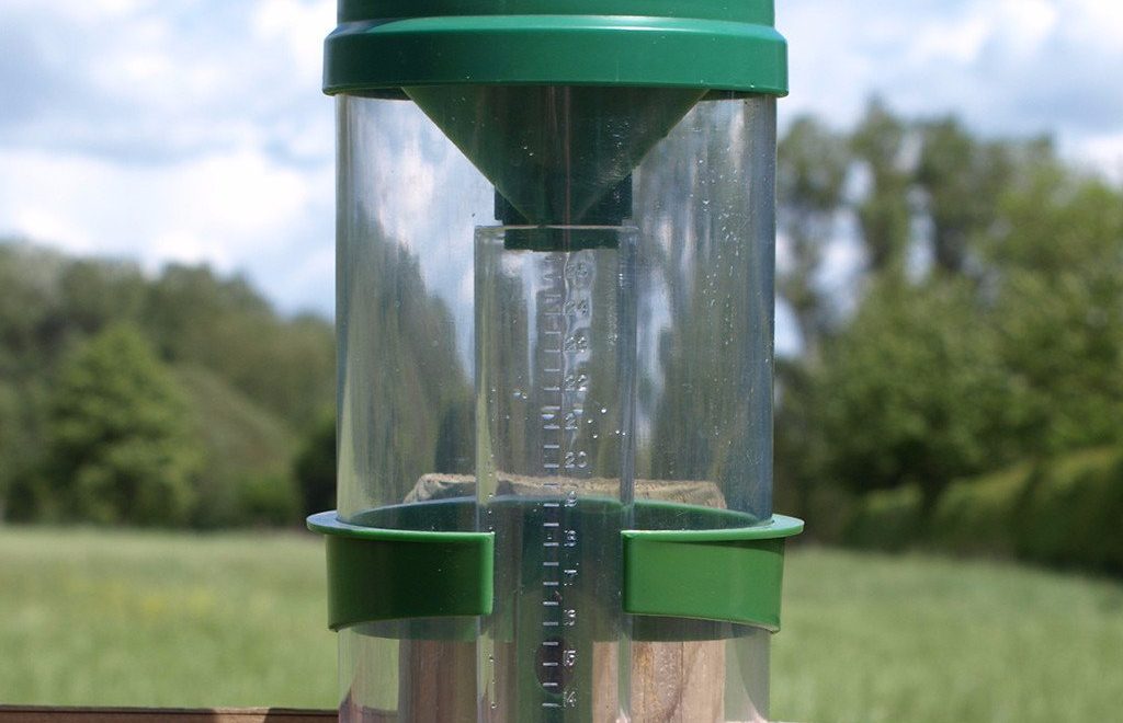
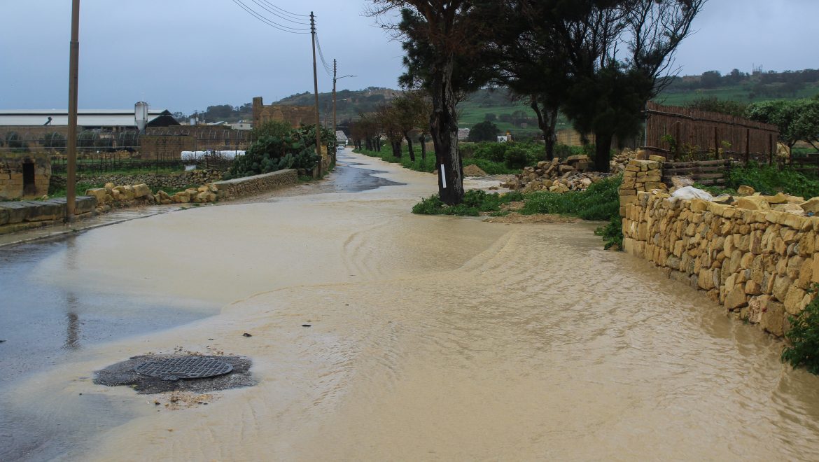
As forecast last week, it’s going to rain at some point on all days till the end of October. Latest map updates have now extended the uninterrupted run of wet days till Friday 01/11. So far we have seen rain on all days since Friday 25/10. Total rainfall has varied across the Maltese Islands. These are the amounts of precipitation we’ve seen so far in some localities:

Għarb: 44.9 mm, Victoria: 45.8 mm, Xewkija: 28.8 mm, Nadur: 22.0 mm, Mellieħa: 29.4 mm, Buġibba: 28.4 mm Mġarr: 51.2 mm, Għargħur: 16.4 mm, Attard: 15.8 mm, Rabat: 48.2 mm, Msida: 10.6 mm, Valletta: 15.8 mm, Luqa: 19.0 mm, Żabbar: 25.9 mm, Birżebbuġa: 17.0 mm

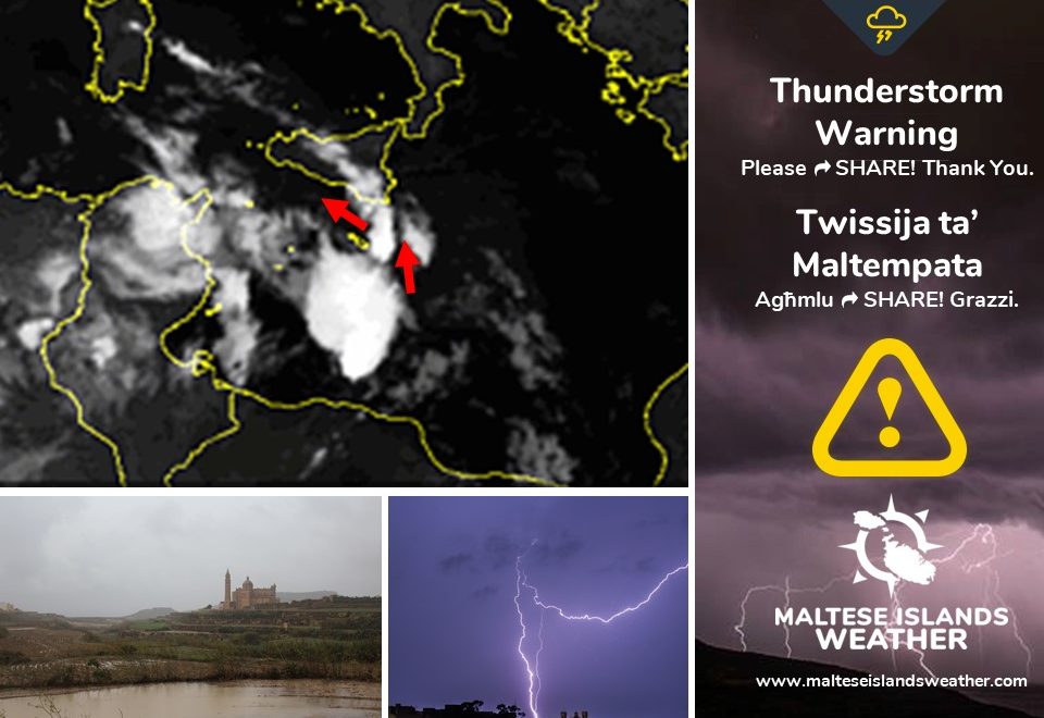
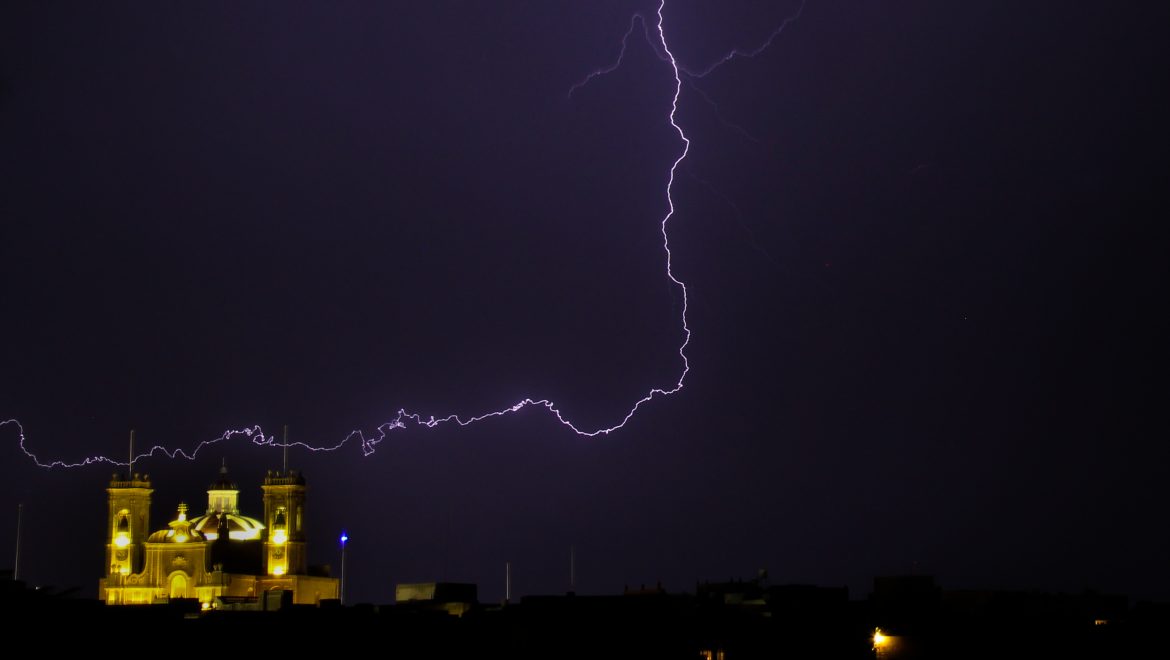
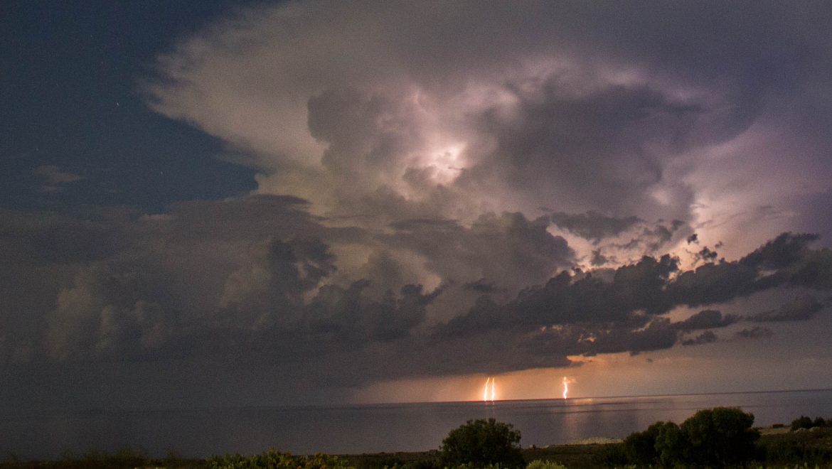
The air temperature during a thunderstorm early on Monday 28/10 dipped to 15.6 C, the coolest air temperature in months.

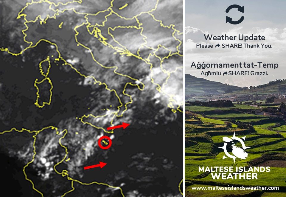
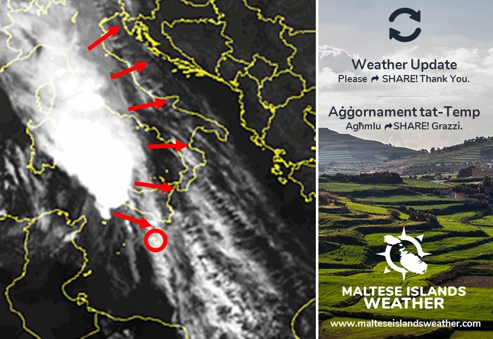
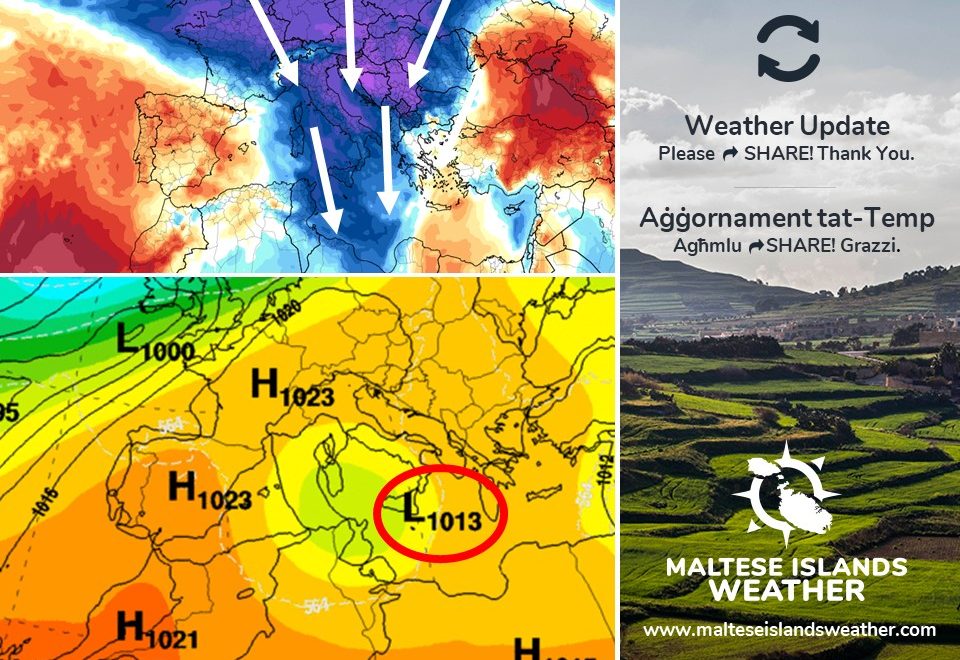
The low pressure system that has brought this inclement weather to the central Mediterranean should remain almost stationary over our region till Friday 01/11. There will be further showers that will be heavy, thundery, blustery and also possibly with hail at times. A further 30 mm to 50 mm could be measured in the wettest localities till this Friday 01/11. A detailed update will be issued ahead of any thunderstorm.

Kif bassarna l-ġimgħa l-oħra, mistennija tagħmel ix-xita f’xi ħin matul il-jiem li ġejjin sa l-aħħar ta’ Ottubru. L-aħħar mapep aġġornati estendew din il-firxa ta’ jiem imxarrba sa nhar il-Ġimgħa 01/11. It-total ta’ xita li ġie imkejjel sa issa varja madwar il-Gżejjer Maltin. Dan huwa t-total ta’ xita li rajna f’xi lokalitajiet sa issa:

Għarb: 44.9 mm, Victoria: 45.8 mm, Xewkija: 28.8 mm, Nadur: 22.0 mm, Mellieħa: 29.4 mm, Buġibba: 28.4 mm Mġarr: 51.2 mm, Għargħur: 16.4 mm, Attard: 15.8 mm, Rabat: 48.2 mm, Msida: 10.6 mm, Valletta: 15.8 mm, Luqa: 19.0 mm, Żabbar: 25.9 mm, Birżebbuġa: 17.0 mm

It-temperatura ta’ l-arja matul maltempata kmieni t-Tnejn 28/10 niżlet sa 15.6 C, l-aktar waħda friska fl-aħħar xhur.

Is-sistema ta’ pressjoni baxxa li wasslet għal dan il-maltemp fi-ċentru tal-Mediterran mistennija tibqa stazzjonarja fuqna sa nhar il-Ġimgħa 01/11. Se jkun hemm aktar ħalbiet tax-xita li se jkunu qawwijin, bir-ragħad, mirjieħa u anke possibilment bis-silġ kultant. 30 mm sa 50 mm aktar ta’ xita jistgħu jiġu mkejjla fl-aktar lokalitajiet milquta sa nhar il-Ġimgħa 01/11. Aġġornament dettaljat jinħareġ qabel maltempati bir-ragħad imminenti.

Updates

This week: A week of rain

Low pressure will dominate across the central Mediterranean throughout much of this week’s weekdays. It will rain at some point on all days till Friday 01/11. The first five days of the week will be characterised by partly to variably cloudy skies with isolated showers possibly heavy and thundery at times. High pressure should take over the central Mediterranean for the weekend, ensuring fine weather on Saturday 02/11 and Sunday 03/11. Wind will be light at first, averaging Force 2/3 till Thursday 31/11. It will increase to Force 4/5 from then on, as strong high pressure over the western Mediterranean contrasts with low pressure to the southeast of the Maltese Islands. A Northwest wind will dominate this week. Temperatures will decrease gradually over the course of this week. Highs will fall from 25 C at the start of the week to 22 C by the weekend. Lows will diminish from 19 C at the start of the week to 16 C by the weekend brasil-libido.com.

Updates

THUNDERSTORM WARNING / TWISSIJA TA’ MALTEMPATA

After the latest model update, we have decided to issue a severe weather warning. The main threat appears to be from a number of thunderstorms. This warning is valid from 09:00 on Sunday 27/10 till 21:00 on Monday 28/10 unless otherwise indicated.

Low pressure over the Gulf of Gabes has pushed an unstable air mass towards the central Mediterranean. Upon coming into contact with the very warm sea around us, this unstable air mass has intensified and will develop  several thunderstorms over the course of these 36 hours. Most will be in the form of squall lines. A squall line is an elongated line of thunderstorms that tends to form along or ahead of a front. A series of others will be in the form of Mesoscale Convective Systems (MCS). An MCS is a complex of organised thunderstorms. In the event of any of these affecting the Maltese Islands, expect rain which will be heavy, thundery, blustery and with hail at times. Totals may exceed 50 mm in the event of direct hits. Further updates will be issued ahead of any thunderstorms.

Wara l-aħħar aġġornament tal-mapep, iddeċidejn li noħorġu twissija ta’ maltemp. It-theddida mill-maltemp jidher li se tkun fil-forma ta’ maltempati bir-ragħad b’saħħithom. Din it-twissija se tkun fis-seħħ minn 09:00 tal-Ħadd 27/10 sa 21:00 tat-Tnejn 28/10. sakemm ma jkunx indikat mod ieħor.

Firxa ta’ pressjoni baxxa fuq il-Golf ta’ Gabes imbuttat massa ta’ arja instabbli lejn iċ-ċentru tal-Mediterran. Hekk kif din ġiet f’kuntatt mal-baħar sħun li hawn madwarna, din il-massa ta’ arja instabbli ntensifikat u se tiżviluppa numru ta’ maltempati bir-ragħad fis-36 siegħa li ġejjin. Il-biċċa l-kbira minn dawn se jkun fil-forma ta’ ‘squall lines’. ‘Squall line’ hija medda fit-tul ta’ maltempati bir-ragħad li ħafna drabi tifforma ma’ fronti fi pressjoni baxxa. L-oħrajn jidher li se jkunu fil-forma ta’ ‘Mesoscale Convective Systems’ (MCS). MCS hijja massa ta’ maltempati bir-ragħad fuq livell organiżżat. F’każ li xi waħda minn dawn taffetwa lill-Gżejjer Maltin stennew xita li tkun qawwija, bir-ragħad, bir-riħ u possibilment anke bis-silġ kultant. It-total ta’ xita jaf jilħaq il-50 mm jekk dawn il-maltempati bir-ragħad jolqtuna direttament. Aktar aġġornamenti jsegwu qabel kull tip ta’ maltempata bir-ragħad.


Updates

Bad weather close to the Maltese Islands / Maltemp qrib il-Gżejjer Maltin

A cold front associated with a low pressure system over the Tyrrhenian Sea should affect the central Mediterranean overnight. Extending all the way from north Italy towards the Sicilian Channel, this cold front will bring very bad weather to Italy. It will affect the Maltese Islands to a much lesser extent. It may affect us at any time this evening or at night. Expect a drop in temperature and a few isolated showers that could be thundery at times. Total rainfall should not exceed 5 mm. The wind will veer West Northwest with the arrival of this cold front. No severe weather is anticipated.

Front ta’ arja kiesħa assoċjat ma’ sistema’ ta’ pressjoni baxxa fuq il-Baħar Tirren mistennija li taffetwa ċ-ċentru tal-Mediterran matul il-lejl. Dan il-front jestendi minn naħa ta’ fuq ta’ l-Italja sal-fliegu ta’ Sqallija, u mistennija jikkawża maltemp kbir fl-Italja. Il-Gżejjer Maltin se jinqabżu bi żbrixx, bl-effetti fuqna jkunu ferm anqas. Dan jista jaffetwana filgħaxija jew billejl. Stennew li t-temperatura titbaxxa daqsxejn u xi ftit ħalbiet iżolati tax-xita li jistgħu jkunu bir-ragħad f’xi ħinijiet. It-total ta’ xita ma għandux jaqbeż il-5 mm. Ir-riħ se jaqleb Punent Majjistru mal wasla ta’ dan il-front kiesaħ. Mhux qed nistennew maltemp sever.

Updates

A change in weather / Taqliba fit-temp

The transition from summer to winter is about to reach another milestone, as a major change in weather conditions is around the corner. This will coincide with the end of summer time this weekend. An intense low pressure system infiltrating our region from the west will herald a lasting change in weather conditions locally. Starting from Friday 25/10, it could rain on all days till the end of October. The wettest weather is expected on Sunday 27/10 and Monday 28/10, when widespread showers which will be heavy and thundery at times should affect the Maltese Islands. Temperatures will also dip considerably. Starting from Friday 25/10, the maximum temperature will be at or below 24 C for good. Nighttime lows will be at or below 19 C for good.

Il-bidla mis-sajf għax-xitwa għandha tibda tinħass sew, hekk kif taqliba kbira fit-temp għandha sseħħ fil-jiem li ġejjin. Din se taħbat sewwa sew ma’ tmiem il-ħin tas-sajf fi tmiem il-ġimgħa. Sistema’ ta’ pressjoni baxxa intensa se tippenetra r-reġjun tagħna mill-punent. Din għandha timmarka bidla permanenti fil-kundizzjonijiet tat-temp lokali. Minn nhar il-Ġimgħa 25/10, se nkunu qed nistennew li tagħmel xi ftit xita kuljum sa l-aħħar tax-xahar. L-aktar li se nkunu qed nistennew xita huwa l-Ħadd 27/10 u t-Tnejn 28/10, meta ħalbiet tax-xita mifruxa li jistgħu ikunu qawwijin u bir-ragħad kultant għandhom jaffetwaw il-Gżejjer Maltin. It-temperaturi ta’ l-arja wkoll se jonqsu b’mod sostanzjali. Minn nhar il-Ġimgħa 25/10, l-ogħla temperatura se tkun ta’ 24 C jew anqas. L-anqas matul il-lejl se tibda tkun ta’ 19 C jew anqas.

Updates

When will it rain? / Meta se tagħmel ix-xita?

An intense low pressure system is currently affecting parts of the Iberian Peninsula. It will affect Italy in the coming hours. Meanwhile, an area of high pressure which has covered the central Mediterranean for much of October will retreat eastwards. This will allow the intense low pressure system to penetrate our region. The weather conditions will deteriorate from late on Thursday 24/10, as this low pressure system starts reaching the Maltese Islands. There will be increasing cloudiness with some isolated showers overnight into Friday 25/10. Saturday 26/10 will be mostly cloudy with possible isolated showers. Rain showers which will be heavy and thundery at times are then expected on both Sunday 27/10 and Monday 28/10. Further isolated showers should then drench the Maltese Islands on Tuesday 29/10 and Wednesday 30/10. More details will be issued in separate updates.

Sistema ta’ pressjoni baxxa intensa qed taffetwa partijiet mill-Peniżola Iberika. Din se taffetwa lil-Italja fis-siegħat li ġejjin. Sadattant, roqgħa ta’ pressjoni għolja li għattiet iċ-ċentru tal-Mediterran għal maġġoranza ta’ Ottubru se tkun qed tersaq lejn il-lvant. Din se tħalli s-sistema ta’ pressjoni baxxa intensa tippenetra r-reġjun tagħna. It-temp għandu jiddeterjora minn tard il-Ħamis 24/10, hekk kif din is-sistema ta’ pressjoni baxxa tilħaqna. Is-sħab se jiżdied u se jkollna xi ftit ħalbiet iżolati tax-xita sa kmieni l-Ġimgħa 25/10. Is-Sibt 26/10 għandu jkun il-biċċa l-kbira msaħħab bil-possibilita’ ta’ xi ħalbiet iżolati tax-xita. Ħalbiet tax-xita li se jkunu qawwijin u bir-ragħad kultant mistennija il-Ħadd 27/10 u t-Tnejn 28/10. Aktar ħalbiet iżolati tax-xita jistgħu jaħkmuna t-Tlieta 29/10 u l-Erbgħa 30/10. Aktar dettalji jsegwu f’aġġornamenti separati.

Updates

Summer time ends / Jispiċċa l-ħin tas-sajf

We set clocks back an hour this weekend. The German Empire and its World War I ally Austria-Hungary were the first to use Daylight Saving Time (DST) as a means of conserving coal during wartime. Others followed suit. Most countries abandoned it in the years following World War II. Since then, the world has seen many enactments, adjustments, and repeals. Much of Africa, Asia, South America and Oceania do not follow it anymore. There are several arguments about this, both in favour and against. Do you think this is still relevant nowadays? Daylight Saving Time ends in the night between Saturday 26/10 and Sunday 27/10, so do not forget to move your clock back one hour before going to bed on Saturday. On Sunday, the sun rises at 06:19 and sets at 17:12, as winter slowly sets in.

Fi tmiem il-ġimgħa l-arloġġi inmexxuhom siegħa lura. L-Imperu Germaniż, flimkien ma’ l-alleati tiegħu ta’ l-Ewwel Gwerra l-Awstrija u l-Ungerija, kienu l-ewwel li ħarġu bl-idea tal-bidla fil-ħin. Dan biex inaqqsu l-konsum tal-faħam fi żmien il-gwerra. Oħrajn għamlu bħalhom. Ħafna pajjiżi ma baqgħux jużaw din is-sistema’ wara t-Tieni Gwerra. Minn dakinhar sa issa, id-dinja rat ħafna tibdil f’din is-sistema’. Ħafna minn l-Afrika, l-Asja, l-Amerka ta’ Isfel u l-Awstralja ma għadhomx b’din is-sistema’ ta’ ħin. Hemm diversi argumenti favur u kontra. Int taħseb li l-bidla fil-ħin għadha relevanti llum il-ġurnata? Il-ħin tas-sajf jasal fi tmiemu matul il-lejl ta’ bejn is-Sibt 26/10 u l-Ħadd 27/10. Għalhekk tinsewx tressqu l-ħin b’siegħa lura qabel torqdu. Nhar il-Ħadd, ix-xemx titla fis-06:19 u tinżel fil-17:12, hekk kif ix-xitwa tkompli toqrob.

Updates

October so far … / Ottubru sa issa …

October will be over in just over a week. The past three weeks have seen warmer than average temperatures and drier than average conditions. With a mean maximum temperature of 25.6 C, daytime highs have so far been 0.8 C warmer than usual. Nighttime lows have followed a similar trend. With an average minimum of 19.9 C, they are currently 2 C warmer than normal. Whilst no extremes were recorded, temperatures were warmer than average on most days. Temperatures will remain stable till the end of October, before a possible dip in the first week of next month. Rainfall so far stands at 45.6 mm at our weather station in Għarb, 37.7 mm short of the climate average for October. With nine days, and three more potential spells of bad weather to go, there is the possibility of the total reaching the average for this month. Rain should return to the Maltese Islands on three occasions: late on the 24th till early on the 25th, late on the 26th till early on the 27th and on the 31st. Further details about will be issued in separate updates.

Ottubru se jispiċċa fi ftit aktar minn ġimgħa. Fl-aħħar tlett ġimgħat rajna temperaturi aktar sħan mill-medja u temp aktar niexef mis-soltu. Bl-ogħla temperatura fil-medja ta’ 25.6 C, it-temperaturi massimi sa issa kienu 0.8 C ogħla mill-medja. It-temperaturi ta’ billejl segwew l-istess sekwenza. Bl-anqas temperatura fil-medja ta’ 19.9 C, din kienet 2 C aktar sħuna minn normal. Għalkemm ma kellna l-ebda estremi, it-temperaturi kienu ogħla mill-medja f’ħafna mill-ġranet. It-temperaturi mistennija jibqgħu stabbli sa l-aħħar ta’ Ottubru, qabel ma potezjalment jaqgħu fl-ewwel ġimgħa ta’ Novembru. Sa issa għamlet 45.6 mm ta’ xita lejn l-Għarb, 37.7 mm anqas mill-medja staġġjonali. B’disa t’ijiem, u potenzjalment tlett episodji ta’ maltemp sa l-aħħar ta’ dan ix-xahar, hemm possibilita’ li l-medja ta’ Ottubru tintlaħaq. Ix-xita għandha tirritorna tlett darbiet: minn tard ta’ l-24 sa kmieni ta’ l-25, minn tard tas-26 sa kmieni tas-27 u fil-31. Aktar dettalji dwar dan jingħataw f’aġġornamenti separati.