Updates

For the latest updates related to the weather in the Maltese Islands. So keep yourself updated by visiting this page frequently or like our Facebook page.

Updates

3 Hourly Forecast for l-Imnarja (29/06/2019)

00:00 to 03:00 – clear; 26 C to 25 C; Calm
03:00 to 06:00 – clear; 25 C to 24 C; Calm
06:00 to 09:00 – clear; 24 C to 30 C; Northeast Force 2/3
09:00 to 12:00 – clear; 30 C to 32 C; Northeast Force 3/4
12:00 to 15:00 – clear; 32 C to 33 C; Northeast Force 3/4
15:00 to 18:00 – clear; 33 C to 31 C; Northeast Force 3/4
18:00 to 21:00 – clear; 31 C to 27 C; Northeast Force 3/4
21:00 to 00:00 – clear; 27 C to 25 C; Northeast Force 3/4

L-Imnarja is a national festival dedicated to the feast of St. Peter and St. Paul. Its roots can be traced back to the Roman feast of Luminaria; when the early summer night of June 29 was illuminated by torches and bonfires. It is also a time when the people celebrate harvest. A national feast since the rule of the Order of St. John, l-Imnarja is a traditional Maltese festival of food, religion and music. Modern Mnarja celebrations are focused on the woodlands of Buskett, just outside the town of Rabat. It is said that under the Knights, this was the one day in the year when the Maltese were allowed to hunt and eat wild rabbit, which was otherwise reserved for the hunting pleasures of the Knights.

Updates

Record-breaking heatwave in Europe / Mewġa ta’ sħana rekord fl-Ewropa

A vast region across western Europe is experiencing a record-breaking heatwave. Heatwave conditions have already caused flash floods and forest fires, grounded planes and buckled train tracks and led to school closures and warnings over air quality. As the mercury continues to soar, with potentially deadly consequences, we take a quick glance at what is behind the worst European heatwave since 2003. Heatwaves across northern Europe occur when an area of persistent high pressure builds up over the British Isles. This draws up hot air from northern Africa, Portugal and Spain. This raises temperatures and increases humidity, creating deadly heatwave conditions. The heatwave will be at its worst on Thursday 27/06 and Friday 28/06. Meteorologists have described this heatwave as ’hell’. Maximum temperatures across Spain, France, Germany and Poland have exceeded 40 C. Maximum temperatures across a number of other countries exceeded 35 C. The hottest city on Friday 28/06 will Zaragoza in Spain, with a high in excess of 45 C. These sweltering temperatures have broken decade old records of maximum June temperatures across western Europe. The Maltese Islands is not to be affected by this particular heatwave, even though temperatures are hot.

Reġjun vast fil-punent ta’ l-Ewropa jinsab għaddej minn mewġa ta’ sħana rekord. Din il-mewġa ta’ sħana diġa kkaġunat għargħar u nirien, waqqfet ajruplani u għamlet ħsarat fis-sistema tal-ferroviji, kif ukoll wasslet biex ingħalqu skejjel u nħarġu twissijiet ta’ kwalita’ ta’ arja baxxa. It-temperatura se jkomplu jogħlew, b’konsegwenzi potenzjalment fatali. Aħna se nagħtu daqqa ta’ għajn lejn x’inhu jikkawża l-agħar mewġa ta’ sħana sa minn l-2003. Mewġa ta’ sħana lejn it-tramuntana ta’ l-Ewropa hija kkawżata minn sistema ta’ pressjoni għolja persistenti fuq ir-Renju Unit. Din tiġbed arja taħraq minn l-Afrika ta’ Fuq, il-Portugall u Spanja. Din twassal biex it-temperaturi jiżdiedu ġmielhom u l-umdita titla għal livelli għoljin ferm. Din il-kumbinazzjoni twassal għal sitwazzjoni perikoluża immens. L-agħar ta’ din il-mewġa ta’ sħana se jintlaħaq il-Ħamis 27/06 u l-Ġimgħa 28/06. Metejoroloġisti ddeskrivew il-mewġa ta’ sħana bħala ‘infern’. Temperaturi massimi fi Spanja, Franza, il-Ġermanja u l-Polonja qabżu l-40 C. Numru ta’ pajjiżi oħrajn raw temperaturi massimi ta’ aktar minn 35 C. L-aktar belt taħraq nhar il-Ġimgħa 28/06 se tkun Żaragoża fi Spanja, bl-ogħla ta’ aktar minn 45 C. Dawn it-temperaturi kisru rekords ta’ temperaturi massimi f’Ġunju li kien ilhom hemm snin twal. Minkejja li t-temperaturi fil-Gżejjer Maltin huma għoljin, mhux se nkunu qed niġu affetwati minn din il-mewġa ta’ sħana.

Updates

What now, after the heatwave? / X’ġej issa, wara l-mewġa ta’ sħana?

The grip of high pressure will prevail across the central Mediterranean. This will be enough to ensure that fine weather continues across the Maltese Islands. Temperatures have decreased slightly, albeit still remaining above average for the time being. Highs will be at around 32 C, while lows will dip to around 23 C. Winds will remain mainly light and variable, with only rare brief spells of moderate winds if at all. Sunny or mainly sunny skies will characterise most of our days, with only rare brief spells of partly to variably cloudy days if at all. Latest maps show absolutely no rain in the near future, exactly as forecast by ourselves a few days ago. Feasts and other local events can go ahead as planned.

Il-morsa ta’ pressjoni għolja fuq iċ-ċentru tal-Mediterran se tkun qed tkompli. Dan se jkun biżejjed biex temp sabiħ ikompli madwar il-Gżejjer Maltin. It-temperaturi naqsu daqsxejn, għalkemm se jibqgħu għola mill-medja għal dawn il-jiem. L-ogħla se tkun fir-reġjun ta’ 32 C, filwaqt li l-anqas se tinżel għal madwar 23 C. Ir-riħ se jkun il-biċċa l-kbira ħafif u varjabbli, u jekk ikollna, xi waqtiet qosra u rari ta’ riħ moderat. Ħafna mill-jiem se jkunu kkaratteriżżati minn sema xemxi jew il-biċċa l-kbira xemxi, u jekk ikollna, xi waqtiet qosra u rari ta’ sema ftit jew wisq imsaħħab. L-aħħar mapep ma juru l-ebda xita għal futur qarib, eżatt kif bassarna aħna stess xi jiem ilu. Festi u avvenimenti oħra jistgħu jsiru kif pjanat.

Updates

Two official heatwaves in June / Żewġ mewġiet ta’ sħana uffiċjali f’Ġunju

The World Meteorological Organisation defines a heat wave as five or more consecutive days of prolonged heat in which the daily maximum temperature is higher than the average maximum temperature by 5°C or more. However, some nations, including Malta, have come up with their own criteria to define a heat wave. In Malta, the national weather service provider at the Malta International Airport Met Office, describes a heat wave as being a period of three or more consecutive days in which the daily maximum temperature is higher than the average maximum by 5°C or more. In previous updates, we have always referred to the World Meteorological Organisation’s definition. However, from now on, we will be adopting the national criteria for a heatwave.

The average maximum for June is of 28.2°C. Using the national criteria for a heatwave in our calculations, we can conclude that the Maltese Islands experienced two heatwaves in June 2019. The first of these lasted for a period of four days, from 09/06/2019 to 12/06/2019. The maximum temperature measured during the first heatwave was of 37°C on 09/06/2019. The second heatwave lasted for a period of four days too, from 21/06/2019 till 24/06/2019. The maximum temperature measured during the second heatwave was of 35°C on 24/06/2019.

Temperatures will decrease slightly from Tuesday 25/06. Maximum temperatures of between 30 C and 32 C and minimum temperatures of between 22 C and 23 C will characterise the rest of June. Hotter temperatures will then mark the start of July. As forecast at the weekend, no rain or thunderstorms is being anticipated for the Maltese Islands anytime soon.

L-Organiżżazzjoni Dinjija tal-Metejoroloġija tiddeskrivi mewġa ta’ sħana (heatwave) bħala ħamest ijiem jew aktar konsekkuttivi ta’ sħana fit-tul bit-temperaturi massimi jaqbżu l-medja massima b’5°C jew aktar. Minkejja dan, xi pajjiżi, inkluż Malta, għandhom it-tifsira tagħhom għal-mewġa ta’ sħana. F’Malta, il-bassara tat-temp nazzjonali fi ħdan l-Uffiċju Metejoroloġiku fl-Ajruport Internazzjonali ta’ Malta, jiddeskrivu mewġa ta’ sħana bħala perjodu ta’ tlett ijiem jew aktar konsekkuttivi li fihom it-temperatura massima taqbeż il-medja massima b’5°C jew aktar. Fil-passat, dejjem irreferejna għad deskrizzjoni ta’ l-Organiżżazzjoni Dinjija tal-Metejoroloġija. Minkejja dan, issa se nibdew nużaw il-kriterja nazzjonali meta nirreferu għal-mewġa ta’ sħana.

Il-medja massima għal Ġunju hija ta’ 28.2°C. Meta nużaw il-kriterja nazzjonali għal-mewġa ta’ sħana fir-rapporti tagħna, nistgħu nikkonkludu li f’Ġunju 2019, il-Gżejjer Maltin esperjenzaw żewġ mewġiet ta’ sħana. L-ewwel minn dawn damet erbgħa t’ijiem, minn 09/06/2019 sa 12/06/2019. It-temperatura massima imkejjla tul l-ewwel mewġa ta’ sħana kienet ta’ 37°C nhar 09/06/2019. It-tieni mewġa ta’ sħana damet erbgħa t’ijiem ukoll, minn 21/06/2019 sa 24/06/2019. It-temperatura massima imkejjla tul it-tieni mewġa ta’ sħana kienet ta’ 35°C nhar 24/06/2019.

It-temperaturi se jonqsu xi daqsxejn minn nhar it-Tlieta 25/06. It-temperaturi massimi se jlaħħqu bejn 30 C u 32 C filwaqt li dawk minimi se jkunu ta’ bejn 22 C u 23 C. Dawn se jikkaratteriżżaw il-bqija ta’ Ġunju. Temperaturi aktar sħan għandhom jirritorna għal bidu ta’ Lulju. Kif imbassar, ma għandna nistennew l-ebda xita jew maltempati fil-Gżejjer Maltin fil-futur qarib.


Updates

This week: Hotter than average throughout

The first day of this week will be the hottest and the last of the current heatwave. The maximum will soar to 36 C on Monday 24/06. Temperatures will decrease slightly from Tuesday 24/06, although they will still remain above average. Highs will rise to 31 C / 32 C on a daily basis, whilst lows will be at 23 C. Real-feels will be particularly high, due to high levels of relative humidity on a number of days. Once again, nighttime calm will prevail throughout this week, with winds set to die down for the night throughout this week. Light and variable winds will dominate during the day throughout this week. The sky will be mainly sunny throughout this week. No rain is expected this week.

Updates

No thunderstorms for the Maltese Islands / Mhux ġejjin maltempati lejn il-Gżejjer Maltin

A local weather service provider is irresponsibly spreading false news that thunderstorms are expected across the Maltese Islands by the end of June and the beginning of July. This is all fake news.

What are we to expect? The grip of high pressure will prevail over the central Mediterranean. This will be enough to ensure that fine weather continues to grace the skies over the Maltese Islands. Heatwave conditions will persist till Monday 24/06, with temperatures at or above 34 C on all days. Temperatures will decrease slightly, albeit still staying above average, from Tuesday 25/06 onward. Highs will be at around 32 C, while lows will dip to around 23 C. Winds will remain mainly light and variable, with only rare brief spells of strong winds if at all. Sunny or mainly sunny skies will characterise most of our days, with only rare brief spells of cloudy days if at all. Latest maps show absolutely no rain in the near future. Festas and other local events can go ahead as planned.


Xi bassar tat-temp lokali qed iferrex aħbar falza b’mod irrisponsabbli. Qed jgħidu li għandna nistennew maltempati bir-ragħad fil-Gżejjer Maltin sa l-aħħar ta’ Ġunju u l-bidu ta’ Lulju. Dan huma kollha aħbarijiet foloz.

X’għandna nistennew allura? Il-morsa ta’ pressjoni għolja fuq iċ-ċentru tal-Mediterran se tkun qed tkompli. Dan se jkun biżejjed biex temp sabiħ ikompli jsaħħar is-sema ta’ madwar il-Gżejjer Maltin. Il-mewġa ta’ sħana kurrenti se tippersisti sa nhar it-Tnejn 24/06, b’temperaturi ta’ 34 C jew aktar. It-temperaturi se jonqsu daqsxejn, għalkemm xorta waħda se jibqgħu aktar mill-medja, mit-Tlieta 25/06 ‘il quddiem. L-ogħla se tkun fir-reġjun ta’ 32 C, filwaqt li l-anqas sejra tinżel għal madwar 23 C. Ir-riħ se jkun il-biċċa l-kbira ħafif u varjabbli, u jekk ikollna, xi waqtiet qosra u rari ta’ riħ qawwi. Ħafna mill-jiem se jkunu kkaratteriżżati minn sema xemxi jew il-biċċa l-kbira xemxi, u jekk ikollna, xi waqtiet qosra u rari ta’ sema msaħħab. Il-mapep ma juru l-ebda xita għal futur qarib. Festi u avvenimenti oħra lokali jistgħu jsiru kif pjanat.


Updates

Seiche, or milgħuba, affects Malta’s east coast!

The sea has recently breached the shoreline in a number of coastal towns and villages in Malta. This was not caused by the tide but is a phenomenon referred to by experts as an “atmospheric tsunami”. Technically known as seiche, or milgħuba in Maltese, the phenomenon is not uncommon and could takeħuba place both in good or bad weather. If the conditions are ideal, the open sea oscillates, creating special signals known as long period waves that are very similar to a tsunami wave. Seiche waves are much smaller than tsunami waves, and they are caused by completely different mechanisms. Seiche waves are caused by fluctuating atmospheric pressure that makes open sea waves rise and fall. Two atmospheric pressure patterns can cause this. An area of high pressure out at sea could push the sea, causing it to rise elsewhere. Conversely, an area of low pressure at the coast could cause the sea to rise. It can also be caused when the wind blows steadily from the same direction for a prolonged period of time. Due to the bay being enclosed, the water oscillates, like water in a bath tub sloshing from one side to the other, and as a result waves could be seen moving out and back into the bay. Very little can be done to prevent this from happening.


Updates

HEAT WAVE WARNING / TWISSIJA TA’ MEWĠA TA’ SĦANA

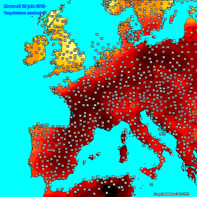
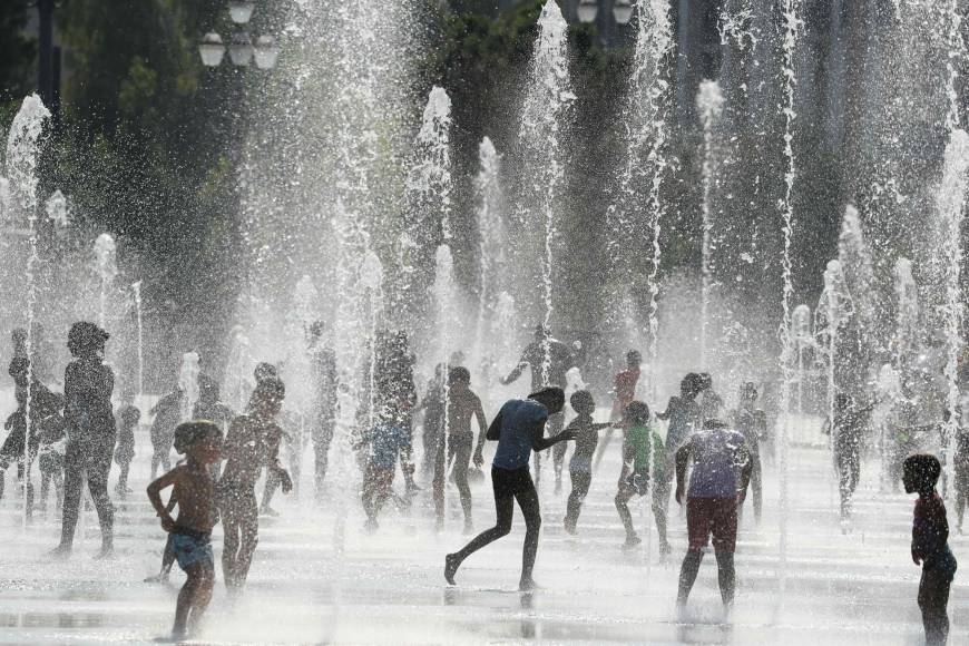
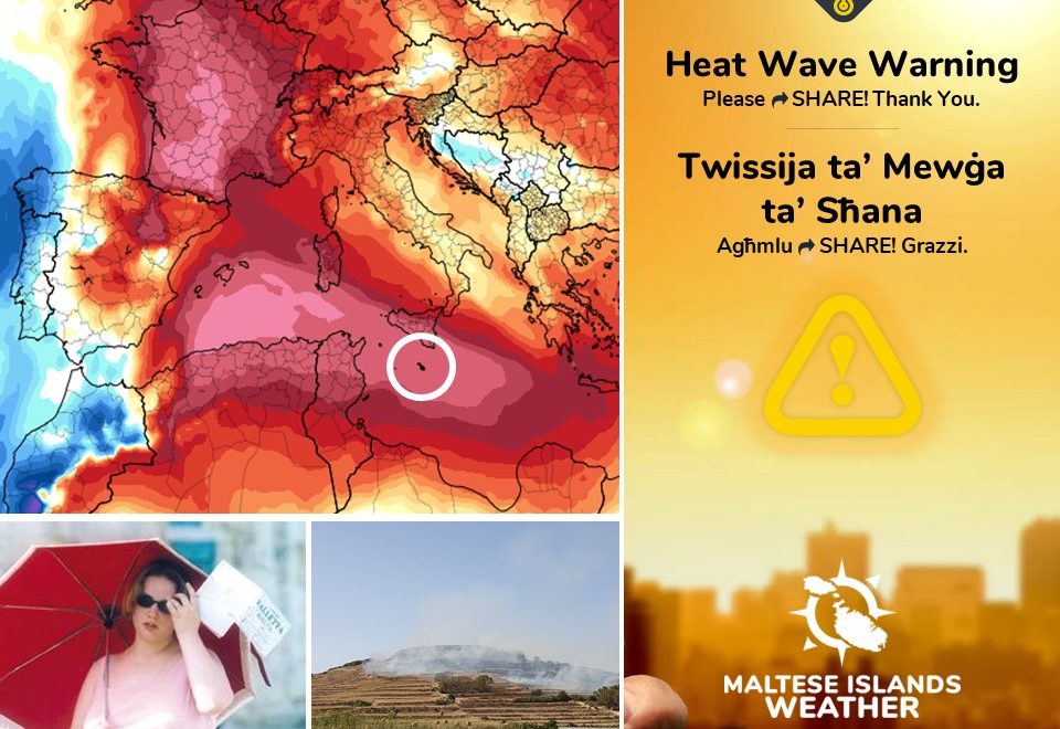
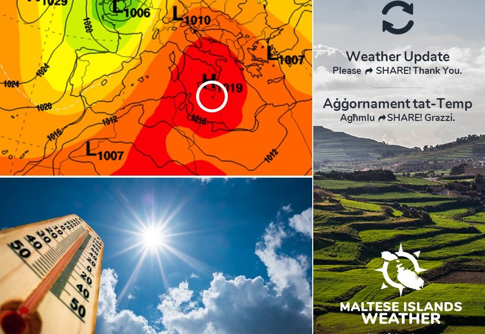
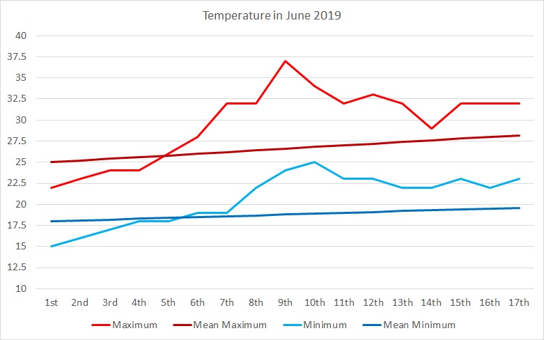
The Maltese Islands will swelter in an intense heat wave during the second half of this week and the first half of next week. The temperatures will be at or above 33 C on all days from Thursday 20/06 till Tuesday 25/06. The mercury will soar to 37 C on Monday 24/06, the hottest day anticipated in this heat wave. Nighttime lows will vary from 23 C to 26 C throughout the duration of this heat wave. The temperatures will be sizzling, and the Maltese Islands will be going through an official heat wave. By definition, a heatwave is a spell of at least five consecutive days with daytime highs exceeding the mean maximum temperature for that particular time of year by 5°C or more. This heat wave will be caused by a low pressure system over northern Europe, which will advect very hot air from a zone of high pressure over north Africa. The relatively high humidity will push real-feel values up. They will reach 40 C at times early in the afternoon. Nights should be very clammy. These real-feel values can lead to dangerous heat disorders with prolonged exposure and/or physical activity in the heat. These include heat cramps, heat exhaustion and heat stroke. Maximum temperatures will dip to 30 C / 31 C from Wednesday 26/06, although nighttime lows will remain at a very warm 23 C / 24 C from then onward. Another heat spell is not ruled out for the end of June and beginning of July.

The UV Index will be at a very high 10. This means an extreme risk of harm from unprotected sun exposure. Take all precautions because unprotected skin and eyes can be damaged in minutes. UV is highest in the early afternoon.

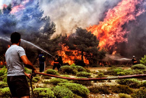
The landscape is parched. The abundant rainfall last winter has caused grass to grow taller than normal. Because of this, some areas are covered in very tall dry grass. Many valleys are covered in reeds. The extreme heat will elevate the risk of grass fires in the coming days. As a result, The Fire Weather Index is at an extremely high level locally.

Be careful and follow these precautions to minimize the risk of any of the hazards mentioned earlier. Precautions include:

– Shut windows and pull down the shades when it is hotter outside. Open again when cool.

– Stay in the coolest part of any building if possible.

– Stay out of the sun and don’t go out between 11am and 4pm.

– Have cool baths or showers.

– Drink cold drinks regularly, such as water or juice. Avoid tea, coffee and alcohol.

– If outdoors, seek shade and wear protective clothing.

– Check up on friends, relatives and neighbours who may be less able to look after themselves.

– Seek medical attention in case of heat-related symptoms.

– Wear SPF 30+ sunscreen and sunglasses.

– Watch out for bright surfaces, like sand and water, which reflect UV and increase exposure.

– Keep all pets and possibly stray animals in a cool area.

– Do not take pets out for walks in the sun (you may have shoes to protect your feet but their paws are in contact with the hot ground).

– Never leave anyone (including pets) in closed vehicles.

– Be more careful with materials conducive to fires (such as BBQs, cigarettes, glass disposal, garden litter etc …)

– Be careful extremely careful with fireworks, especially burning debris falling from the sky.

Remember that babies, young children, people with underlying conditions, pregnant women, the elderly and others whose job includes being physically active are at a greater risk.


Il-Gżejjer Maltin se jgħaddu minn perjodu ieħor ta’ sħana qawwija ħafna tul it-tieni parti ta’ din il-ġimgħa u l-bidu tal-ġimgħa id-dieħla. It-temperaturi se jilħqu 33 C jew aktar fil-jiem kollha mill-Ħamis 20/06 sat-Tlieta 25/06. It-temperatura se titla sa 37 C nhar it-Tnejn 24/06, l-aktar jum sħun f’din il-mewġa ta’ sħana. L-anqas billejl se jvarjaw minn 23 C sa 26 C matul din il-mewġa ta’ sħana. Id-definizzjoni ta’ mewġa ta’ sħana hija ħamest ijiem konsekuttivi jew aktar b’temperaturi massimi li jaqbżu l-medja għal dak iż-żmien tas-sena b’5 C jew aktar. Din il-mewġa ta’ sħana se tkun ikkawżata minn sistema ta’ pressjoni baxxa fin naħa ta’ fuq ta’ l-Ewropa li se tiġbed arja taħraq ħafna minn żona ta’ pressjoni għolja fuq l-Afrika ta’ fuq. L-arja umda se twassal biex it-temperaturi jkunu jinħassu aktar sħan. L-ogħla ta’ 37 C taf tkun tinħass daqs li kieku 40 C. L-iljieli se jkunu umdi wkoll. Dawn il-valuri jistgħu iwasslu għal xi kundizzjonijiet assoċjati ma’ sħana qawwija ħafna. Dawn jinkludu ‘heat cramps’, ‘heat exhaustion’ u ‘heat stroke’. It-temperaturi massimimi se jinżlu għal 30 C / 31 C minn nhar il-Erbgħa 26/06, għalkemm dawk minimi se jibqgħu 23 C / 24 C. Mewġa ta’ sħana oħra hija possibli lejn l-aħħar ta’ Ġunju u l-bidu ta’ Lulju.

L-indiċi UV se tkun f’livell għoli ta’ 10. Dan ifisser riskju estrem ta’ ħsara mix-xemx. Ħudu il-prekawzzjonijiet kollha peress li ġilda u għajnejn mhux protetti jistgħu isofru ħsara f’ħin qasir. Il-UV tkun l-ogħla kmieni wara nofsinhar.

Il-kampanja bħalissa niexfa. Ix-xita abbundanti tax-xitwa li għaddiet wasslet biex il-ħaxix twal aktar minn normal. Minħabba dan, xi nħawi huma miksija b’ħaxix twil ħafna u niexef. Il-widien ikunu mimlija qasab. Is-sħana estrema se twassal biex ir-riskju ta’ nirien ikun elevat.

Oqgħodu attenti u segwu dawn il-messaġġi ta’ prekawzjonijiet biex tnaqqsu r-riskju tal-perikli msemmija hawn fuq.

– Agħlqu t-twieqi u l-blinds/shutters fl-eqqel tas-sħana. Erġa iftaħ x’ħin jiffriska.

– Oqgħodu fl-aktar parti friska tal-bini.

– Evitaw li toqgħodu fix-xemx bejn 11am u 4pm.

– Inħaslu b’ilma frisk.

– Ixorbu xarbiet kesħin ta’ spiss. Pruvaw evitaw te’, kafe’ u alkoħol.

– Jekk tkunu barra, sibu d-dell u lbsu lbies addattat, kappell u nuċċali tax-xemx.

– Iċċekjaw li qraba, ħbieb u ġirien li ma jistgħux jieħdu ħsieb tagħhom infushom, ikunu sew.

– Ikkonsulta tabib f’każ ta’ sintomi marbuta ma’ kundizzjonijiet ta’ sħana

– Użaw SPF 30% sunscreen u nuċċali tax-xemx.

– Żommu l-annimali tagħkom u anke dawk tat-triq jekk possibbli f’post frisk.

– Toħorġux lil klieb jimxi fix-xemx (intom għandkom żarbun jipproteġikom mil-art tikwi, l-annimali ma għandhomx).

– Qatt tħalli lil ħadd, inkluż annimali, f’vetturi.

– Użaw materjali fjammabbli b’aktar reqqa (bħal BBQs, sigaretti, ħġieġ, kimiċi tal-pool, skart organiku etc …).

– Oqogħdu attenti mill-logħob tan-nar.

Ftakkru li trabi, tfal żgħar, nies b’kundizzjonijiet li ma jidhrux, nisa tqal, xjuħ u nies li jaħdmu fuq barra għandhom riskju akbar.

Updates

June to end with a bang / Ġunju se jispiċċa bil-kbir

Latest maps are indicating with great confidence, that June will come to end with a bang. Temperatures are right now slightly cooler than as of late, albeit still being slightly above average. A very hot air mass from over north Africa will take over the central Mediterranean by the weekend, marking the start of the second heatwave of the year. The Maltese Islands will once again be among the hottest around Europe for the last week of June. Maps indicate that maximum temperatures will be at or above 34 C from Friday 21/06 onward. The hottest days are set to be Sunday 23/06 and Monday 24/06, when highs could exceed 36 C. Winds will be mainly light and variable throughout. Humidity will be relatively high, allowing for realfeels to reach or exceed the 40 C mark.

L-aħħar mapep qed jindikaw b’kunfidenza kbira li Ġunju għandu jispiċċa bil-kbir. It-temperaturi bħalissa huma ftit aktar friski minn dan l-aħħar, għalkemm xorta waħda baqgħu ogħla mill-medja. Massa ta’ arja taħraq minn fuq l-Afrika ta’ fuq se tgħatti ċ-ċentru tal-Mediterran minn tmiem il-ġimgħa, biex b’hekk tati bidu għat-tieni mewġa ta’ sħana għal din is-sena. Għal darb’oħra, matul l-aħħar ġimgħa ta’ Ġunju, l-Gżejjer Maltin se jerġgħu jkunu minn l-aktar sħan fl-Ewropa. Il-mapep qed jindikaw li t-temperaturi massimu se jmissu l-34 C jew fuqhom minn nhar il-Ġimgħa 21/06 ‘il quddiem. L-aktar jiem sħan għandhom ikunu l-Ħadd 23/06 u t-Tnejn 24/06, meta l-ogħla tkun aktar minn 36 C. Ir-riħ se jkun ħafif u varjabbli. L-umdita se tkun relattivament għolja, u għalhekk it-temperaturi jkunu jinħassu daqs li kieku 40 C.

Reports, Updates

June so far / Ġunju sa issa

With an average high of 29.7 C and an average low of 20.7 C, June 2019 has so far been more than 2 C warmer than normal. That’s more than the 0.25 C forecast at the start of the month. The maximum temperature so far this month was reached on the 9th, when it had soared to a sweltering 37 C. That was just more than 10 C hotter than the mean for that time of year. With a low of 25 C, the following night was the warmest so far this month. Having reached mid-month, we can safely say that June 2019 is now following the same pattern as in June 2012 and June 2017, two years with very hot summers. Just two weeks ago, many were fearing that there would be no summer this year. This fear was for very good reason too, as the beginning of June was one of the most unsettled on record.

In contrast to what long-term maps showed some weeks ago, the latest versions almost all agree that summer will be hotter than average by at least 1 C. Precipitation will be very close to average. An average summer is completely to almost completely dry. The hottest part of this year’s summer is expected to be around mid-August.

B’medja massima ta’ 29.7 C u medja minima ta’ 20.7 C, Ġunju 2019 kien aktar minn 2 C aktar sħun minn normal sa issa. Dan jaqbeż iż-0.25 C li kien imbassar fil-bidu tax-xahar. L-aktar temperatura għolja sa issa dan ix-xahar laħqet 37 C u kienet imkejjla fid-9 tax-xahar. Dan qabeż il-medja għal dan iż-żmien tas-sena b’10 C. Bl-anqas ta’ 25 C, il-lejl ta’ wara kien l-aktar sħun ta’ dan ix-xahar. Hekk kif wasalna f’nofs ix-xahar, nistgħu nikkonkludu li Ġunju 2019 qed isegwi l-istess sinjali ta’ Ġunju 2012 u Ġunju 2017, sentejn li fihom esperjenzajna sjuf sħan ferm. Sa ħmistax ilu biss, ħafna kienu ħasbu li kienet se tkun sena bla sajf. Kien bir-raġuni wkoll, peress li l-bidu ta’ Ġunju ta’ din is-sena kien mill-aktar instabbli.

B’differenza lejn kif mudelli tat-temp kienu qed juru ġimgħat ilu, dawk aktar riċenti qed jaqblu li dan is-sajf għandu jkun qieħed aktar sħun minn normal, saħansitra b’aktar minn 1 C. It-total ta’ xita se jkun ħafna qrib il-medja. Jekk inħarsu lejn sajf tipiku Malti, ftit li xejn ikollna xita fih. L-aktar parti taħraq ta’ dan is-sajf għandha tkun lejn nofs ix-xahar ta’ Awwissu.