Updates

For the latest updates related to the weather in the Maltese Islands. So keep yourself updated by visiting this page frequently or like our Facebook page.

Updates

This week: A hot start to summer

Temperatures will decrease slightly at the beginning of this week. They will still remain hot though, with maximum temperatures set to be in the lower 30s. This ‘cooler’ weather will prevail till midweek, before it heats up again for what should be the second heatwave of the month. Maximum temperatures will rise to above 33 C again by this weekend, with a sweltering 36 C expected on Sunday 23/06. Nighttime lows will follow more or less the same trend, decreasing to 20 C by midweek, and rising again to 24 C by the weekend. Nighttime calm will prevail throughout this week, with winds set to die down for the night throughout this week. Light and variable winds will dominate during the day throughout this week. The sky will be mainly sunny on most days. It could become cloudy at times on a number of days though. No rain is expected this week.

Updates

Good news about jellyfish / Aħbar tajba rigward il-bram

There is some good news for those of you who simply love to swim. Till now, countless bays around the Maltese Islands have been plagued by extensive jellyfish blooms. As described in a post last weekend, this year’s jellyfish bloom occurred very late. Jellyfish blooms only occur at specific sea surface temperatures. This year, because of unseasonably cold spring weather, the ideal environmental conditions for jellyfish blooms were only reached weeks ago. All this is about to change though, thanks to a heat spell which has gripped much of the western and central Mediterranean. The intense heat will help in raising sea surface temperature. The sea surface temperature was still at 20 C last weekend. 20 C is ideal for jellyfish blooms. Yesterday, the sea surface temperature rose to 21 C. Over the coming days it will continue to rise, hitting the 23 C level by the weekend. This means that environmental conditions will no longer favour jellyfish blooms, allowing you to enjoy the many beaches more comfortably and safely.

Għandna aħbar tajba għal dawk li jħobbu jgħumu. Sa issa, ħafna bajjiet madwar il-Gżejjer Maltin sfaw miżgħuda b’ħafna bram. Kif deskritt f’post fi tmiem il-ġimgħa, il-jellyfish blooms ta’ din is-sena seħħew tard ferm. Jellyfish blooms iseħħu biss f’temperaturi tal-baħar speċifiċi. Din is-sena, minħabba li kellna rebbiegħa kiesħa aktar mis-soltu, il-kundizzjonijiet ambjentali ideali għal jellyfish blooms ġew milħuqa ftit ġimgħat ilu. Dan kollu se jinbidel pero, grazzi għas-sħana li ħakmet il-punent u ċ-ċentru tal-Mediterran. Din is-sħana intensa se twassal biex tibda tiela t-temperatura tal-baħar. It-temperatura tal-baħar kienet għadha 20 C fi tmiem il-ġimgħa. 20 C huwa ideali għal jellyfish blooms. Il-bieraħ, it-temperatura tal-baħar laħqet 21 C. Fil-jiem li ġejjin din se tkompli togħla, u se tilħaq 23 C fi tmiem il-ġimgħa. Dan ifisser li l-kundizzjonijiet ambjentali mhux se jibqgħu jiffavorixxu jellyfish blooms, u għalhekk se tkunu tistgħu tgawdu l-ħafna bajjiet tagħna b’aktar kumdita u sigurta.

Updates

EXTENDED HEAT SPELL WARNING / TWISSIJA TA’ SĦANA ESTIŻA

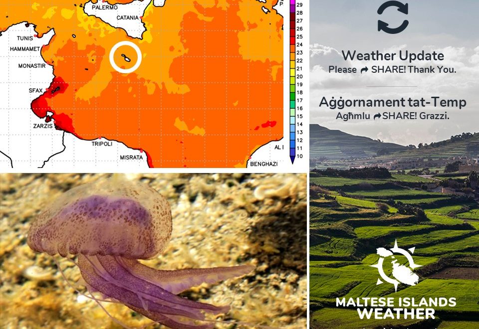
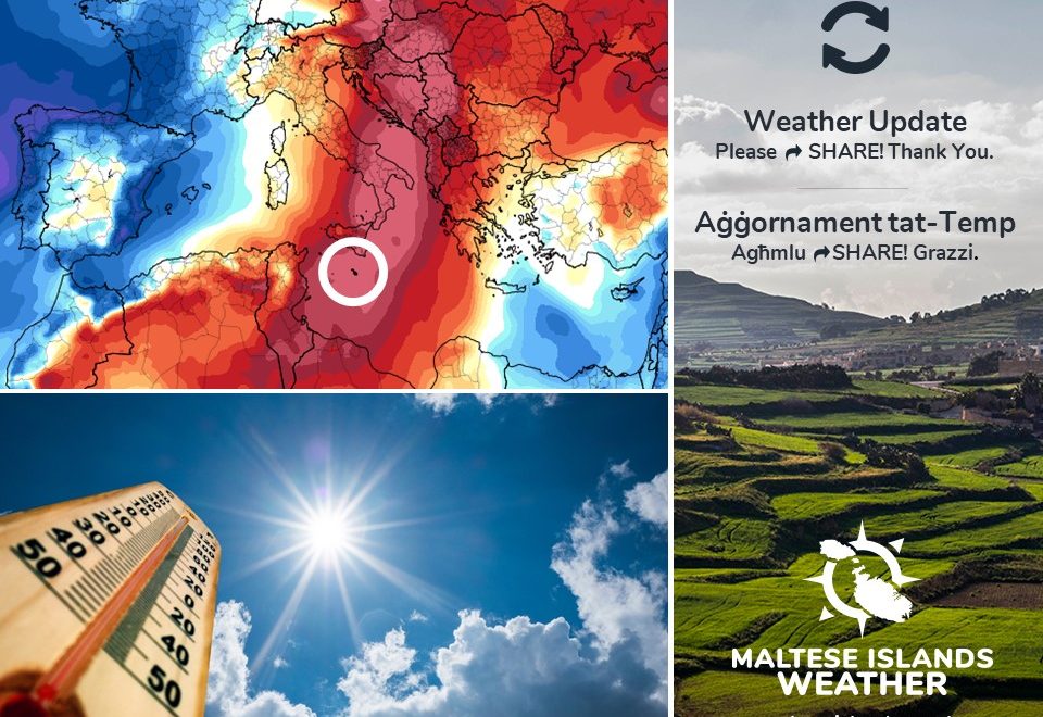
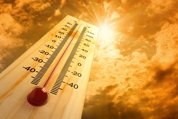
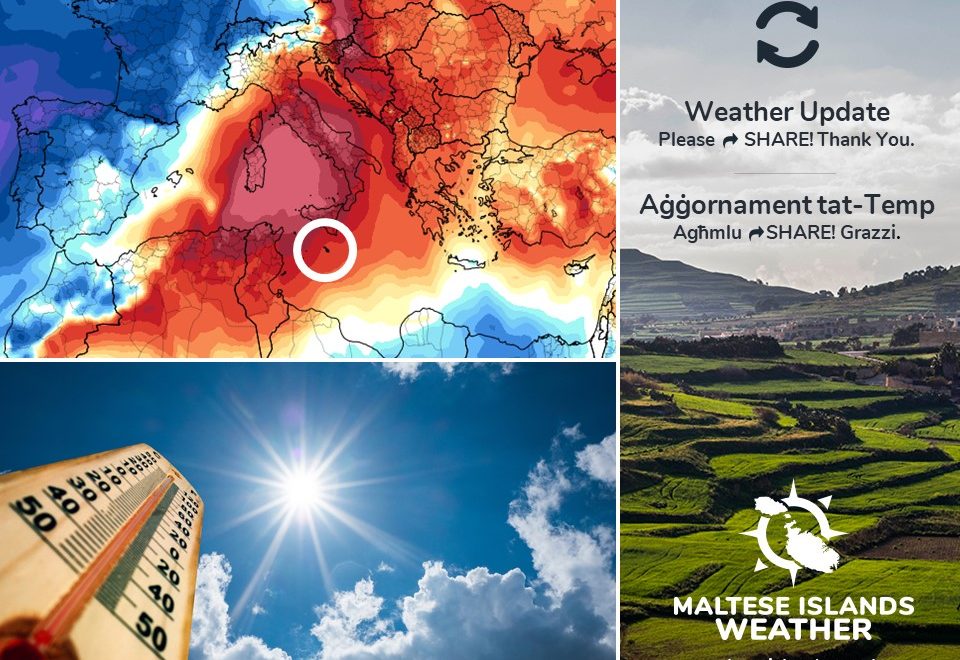
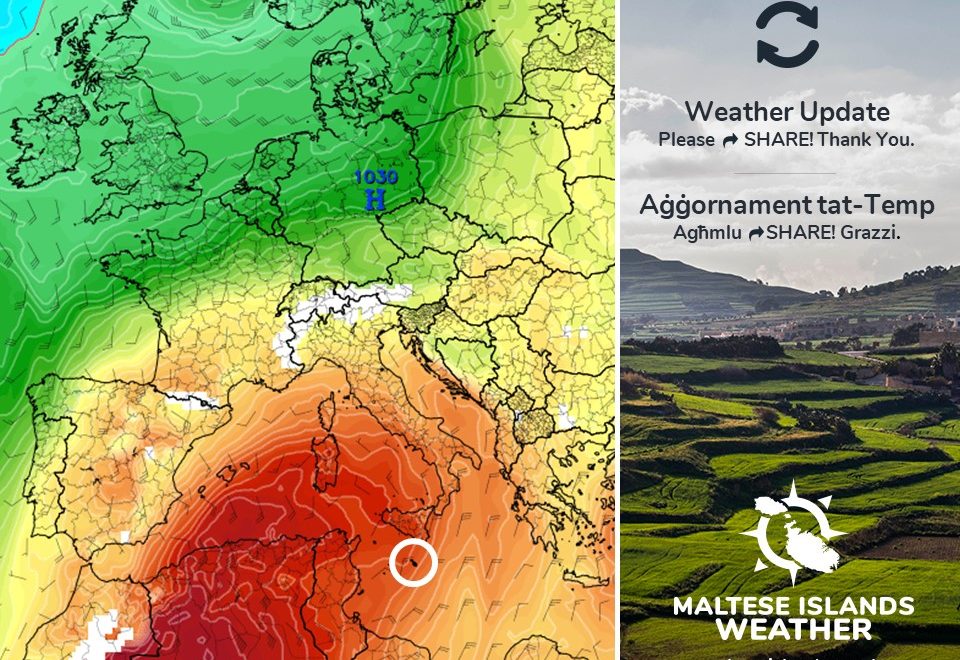
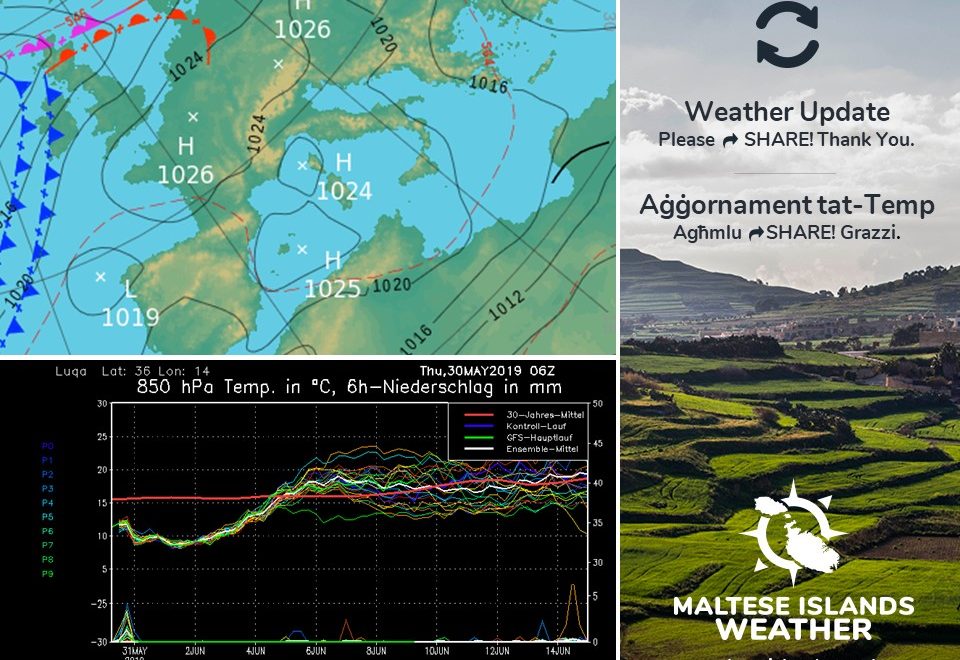
The temperature soared to 37 C on Sunday 09/06 and Monday 10/06. Initially, the heat spell was expected to last till midweek. Latest maps indicate that it will last till Sunday 16/06, albeit with slightly cooler temperatures. Maximum daytime highs till Sunday 16/06 will reach 33 C. Nighttime lows will be at 24 C on all nights. Winds will be mainly from the Southeast. This will mean higher levels of humidity, and therefore, even hotter realfeels. The situation will change late on Sunday 16/06, when the wind turns Northwest. The Northwest wind will mean more seasonable highs of 29 C / 30 C and lows of 20 C / 21 C from Monday 17/07 onward. No rain is being anticipated for the time being.

The UV Index will be at a very high 10. This means an extreme risk of harm from unprotected sun exposure. Take all precautions because unprotected skin and eyes can be damaged in minutes. UV is highest in the early afternoon.

The landscape is parched. The abundant rainfall last winter has caused grass to grow taller than normal. Because of this, some areas are covered in very tall dry grass. Many valleys are covered in reeds. The extreme heat will elevate the risk of grass fires in the coming days. As a result, The Fire Weather Index is at an extremely high level locally.

Be careful and follow these precautions to minimize the risk of any of the hazards mentioned earlier. Precautions include:

– Shut windows and pull down the shades when it is hotter outside. Open again when cool.

– Stay in the coolest part of any building if possible.

– Stay out of the sun and don’t go out between 11am and 4pm.

– Have cool baths or showers.

– Drink cold drinks regularly, such as water or juice. Avoid tea, coffee and alcohol.

– If outdoors, seek shade and wear protective clothing.

– Check up on friends, relatives and neighbours who may be less able to look after themselves.

– Seek medical attention in case of heat-related symptoms.

– Wear SPF 30+ sunscreen and sunglasses.

– Watch out for bright surfaces, like sand and water, which reflect UV and increase exposure.

– Keep all pets and possibly stray animals in a cool area.

– Do not take pets out for walks in the sun (you may have shoes to protect your feet but their paws are in contact with the hot ground).

– Never leave anyone (including pets) in closed vehicles.

– Be more careful with materials conducive to fires (such as BBQs, cigarettes, glass disposal, garden litter etc …)

– Be careful extremely careful with fireworks, especially burning debris falling from the sky.

Remember that babies, young children, people with underlying conditions, pregnant women, the elderly and others whose job includes being physically active are at a greater risk.


It-temperatura sparat għal 37 C nhar il-Ħadd 09/06 u t-Tnejn 10/06. Għal-ewwel, il-mewġa ta’ sħana kienet mistennija ddum sa nofs il-ġimgħa. L-aħħar mapep indikaw li din għandha tibqa sejra sa nhar il-Ħadd 16/06 minflok. Minkejja dan, it-temperaturi mhux se jibqgħu sħan daqs kemm kienu dan l-aħħar. L-ogħla temperatura sa nhar il-Ħadd 16/06 se jitilgħu għal 33 C. L-anqas billejl se tinżel sa 24 C. Ir-riħ se jkun il-biċċa l-kbira mix-Xlokk. Dan ifisser livelli għoljin ta’ umdita, u għalhekk, it-temperaturi se jinħassu ferm aktar sħan. Is-sitwazzjoni mistennija tinbidel tard il-Ħadd 16/06, meta r-riħ idur Majjistral. Ir-riħ mill-Majjistral se jġib temperaturi aktar staġġjonali ta’ 29 C / 30 C bħala massimi u 20 C / 21 C billejl minn nhar it-Tnejn 17/07 ‘il quddiem. Mhux qed nistennew xita għal issa.

L-indiċi UV se tkun f’livell għoli ta’ 10. Dan ifisser riskju estrem ta’ ħsara mix-xemx. Ħudu il-prekawzzjonijiet kollha peress li ġilda u għajnejn mhux protetti jistgħu isofru ħsara f’ħin qasir. Il-UV tkun l-ogħla kmieni wara nofsinhar.

Il-kampanja bħalissa niexfa. Ix-xita abbundanti tax-xitwa li għaddiet wasslet biex il-ħaxix twal aktar minn normal. Minħabba dan, xi nħawi huma miksija b’ħaxix twil ħafna u niexef. Il-widien ikunu mimlija qasab. Is-sħana estrema se twassal biex ir-riskju ta’ nirien ikun elevat.

Oqgħodu attenti u segwu dawn il-messaġġi ta’ prekawzjonijiet biex tnaqqsu r-riskju tal-perikli msemmija hawn fuq.

– Agħlqu t-twieqi u l-blinds/shutters fl-eqqel tas-sħana. Erġa iftaħ x’ħin jiffriska.

– Oqgħodu fl-aktar parti friska tal-bini.

– Evitaw li toqgħodu fix-xemx bejn 11am u 4pm.

– Inħaslu b’ilma frisk.

– Ixorbu xarbiet kesħin ta’ spiss. Pruvaw evitaw te’, kafe’ u alkoħol.

– Jekk tkunu barra, sibu d-dell u lbsu lbies addattat, kappell u nuċċali tax-xemx.

– Iċċekjaw li qraba, ħbieb u ġirien li ma jistgħux jieħdu ħsieb tagħhom infushom, ikunu sew.

– Ikkonsulta tabib f’każ ta’ sintomi marbuta ma’ kundizzjonijiet ta’ sħana

– Użaw SPF 30% sunscreen u nuċċali tax-xemx.

– Żommu l-annimali tagħkom u anke dawk tat-triq jekk possibbli f’post frisk.

– Toħorġux lil klieb jimxi fix-xemx (intom għandkom żarbun jipproteġikom mil-art tikwi, l-annimali ma għandhomx).

– Qatt tħalli lil ħadd, inkluż annimali, f’vetturi.

– Użaw materjali fjammabbli b’aktar reqqa (bħal BBQs, sigaretti, ħġieġ, kimiċi tal-pool, skart organiku etc …).

– Oqogħdu attenti mill-logħob tan-nar.

Ftakkru li trabi, tfal żgħar, nies b’kundizzjonijiet li ma jidhrux, nisa tqal, xjuħ u nies li jaħdmu fuq barra għandhom riskju akbar.

Updates

This week: Heatspell to continue

A heatspell that has gripped the Maltese Islands last weekend will extend into this week. An anticyclone over much of the western and central Mediterranean will prevail. As a result, maximum temperatures will remain above 33 C throughout the week. Nighttime lows will be at 24 C throughout the week. There will be a strong twist, however. Whereas the past few days were characterised by dry winds from the North, the coming week will be dominated by southerly winds. These will bring with them abundant moisture. This abundant moisture will mean higher levels of humidity and thus hotter realfeels. The sky will be sunny or mainly sunny on most days. It could become cloudy at times on a number of days though. Any cloudy skies will be the result of elevated humidity levels https://southafrica-ed.com/kamagra-in-south-africa/. Daytime highs will be at an average of 34 C (6 C higher than average) while nighttime lows will be at a mean of 24 C (5 C higher than average). The hottest days will be Monday 10/06 and Saturday 15/06, when the mercury will soar to 36 C. The coolest will be Wednesday 12/06 with a maximum temperature of 32 C. No rain is to be expected this week.

Updates

The hottest day of 2019? / L-aktar ġurnata sħuna ta’ l-2019?

We’re still 2 weeks away from astronomical summer, but the first heat spell is already taking hold of the Maltese Islands. After a poor start to summer, some even thought we would have no summer this year. Temperatures will exceed the 33 C mark everyday till Tuesday 11/06. With a maximum temperature of 36 C, Sunday 09/06 is set to become the hottest day of 2019 so far. It may also end up being the hottest day of 2019!

Minkejja li għadna ħmistax bogħod mill-bidu tas-sajf, l-ewwel mewġa ta’ sħana diġa qed taħkem lill-Gżejjer Maltin. Wara bidu fqir għar-rebbiegħa, xi wħud saħansitra ħasbu li mhux se jkollna sajf din is-sena. It-temperaturi se jkunu qed jaqbżu t-33 C kuljum sa nhar it-Tlieta 11/06. B’massimu ta’ 36 C, il-Ħadd 09/06 se jkun l-aktar ġurnata sħuna ta’ l-2019 sa issa. Jaf tkun ukoll l-aktar ġurnata sħuna tas-sena 2019!

Updates

3 Hourly Forecast for Sette Guigno (07/06/2019)

00:00 to 03:00 – clear; 21 C to 20 C; Calm
03:00 to 06:00 – clear; 20 C to 21 C; Calm
06:00 to 09:00 – clear; 21 C to 26 C; Southeast Force 2/3
09:00 to 12:00 – clear; 26 C to 31 C; Southeast Force 2/3
12:00 to 15:00 – clear; 31 C to 30 C; Southeast Force 2/3
15:00 to 18:00 – clear; 30 C to 28 C; Southeast Force 2/3
18:00 to 21:00 – clear; 28 C to 24 C; Calm
21:00 to 00:00 – clear; 24 C to 22 C; Calm 

Sette Guigno is a Maltese national holiday celebrated annually on June 7. In the aftermath of World War I, with the disruptions in agriculture and industry across the whole of the European continent, the Maltese colonial government failed to provide an adequate supply of basic food provisions for the island. In response to this, there were a series of riots in the Maltese Islands. On that day in 1919 when, following one of the riots by the Maltese population, British troops fired into the crowd, killing four.

Updates

HEAT SPELL WARNING / TWISSIJA TA’ SĦANA

The Maltese Islands will swelter in an intense heat spell this weekend and the first half of next week. The mercury will soar to 36 C on Sunday 09/06 and Monday 10/06, the hottest days in this heat spell. Other hot days will be Saturday 08/06 and Monday 10/06, when a maximum temperature of 33 C is to be expected. Nighttime lows will be at 23 C / 24 C during the heat spell. The temperatures will be sizzling, but the Maltese Islands will not be going through a heatwave ed-hrvatski.com. By definition, a heatwave is a spell of at least five consecutive days with daytime highs exceeding the mean maximum temperature for that particular time of year by 5°C or more. This heat spell will be caused by a mass of hot air which will emerge from north Africa to engulf the western and central Mediterranean. Maximum temperatures should dip to 30 C / 31 C from Tuesday 11/06 onward. Nighttime lows will be at 20 C / 21 C from then onward.

The UV Index will be at a very high 10. This means an extreme risk of harm from unprotected sun exposure. Take all precautions because unprotected skin and eyes can be damaged in minutes. UV is highest in the early afternoon.

The landscape is parched. The abundant rainfall last winter has caused grass to grow taller than normal. Because of this, some areas are covered in very tall dry grass. Many valleys are covered in reeds. The extreme heat will elevate the risk of grass fires in the coming days. As a result, The Fire Weather Index is at an extremely high level locally.

Be careful and follow these precautions to minimize the risk of any of the hazards mentioned earlier. Precautions include:

– Shut windows and pull down the shades when it is hotter outside. Open again when cool.

– Stay in the coolest part of any building if possible.

– Stay out of the sun and don’t go out between 11am and 4pm.

– Have cool baths or showers.

– Drink cold drinks regularly, such as water or juice. Avoid tea, coffee and alcohol.

– If outdoors, seek shade and wear protective clothing.

– Check up on friends, relatives and neighbours who may be less able to look after themselves.

– Seek medical attention in case of heat-related symptoms.

– Wear SPF 30+ sunscreen and sunglasses.

– Watch out for bright surfaces, like sand and water, which reflect UV and increase exposure.

– Keep all pets and possibly stray animals in a cool area.

– Do not take pets out for walks in the sun (you may have shoes to protect your feet but their paws are in contact with the hot ground).

– Never leave anyone (including pets) in closed vehicles.

– Be more careful with materials conducive to fires (such as BBQs, cigarettes, glass disposal, garden litter etc …)

– Be careful extremely careful with fireworks, especially burning debris falling from the sky.

Remember that babies, young children, people with underlying conditions, pregnant women, the elderly and others whose job includes being physically active are at a greater risk.


Il-Gżejjer Maltin se jkunu qed jesperjenzaw sħana qawwija tul tmiem il-ġimgħa u l-ewwel nofs tal-ġimgħa li ġejja. It-temperatura se tkun qed tilħaq 36 C nhar il-Ħadd 09/06 u t-Tnejn 10/06, l-aktar jiem sħan f’din il-mewġa ta’ sħana. Jiem oħra sħan se jkunu s-Sibt 08/06 u t-Tnejn 10/06, bl-ogħla ta’ 33 C. It-temperaturi billejl se jkunu ta’ madwar 23 C / 24 C matul il-mewġa ta’ sħana. It-temperaturi se jkun jixwu, imma din is-sħana mhux mistennija tkun ‘heatwave’. Dan minħabba li ‘heatwave’ hija ħamest ijiem konsekuttivi jew aktar b’temperaturi massimi li jaqbżu l-medja għal dak iż-żmien tas-sena b’5 C jew aktar. Din-mewġa ta’ sħana se tkun qed tiġi kkaġunata minn massa ta’ arja sħuna li se titla minn l-Afrika ta’ fuq u tgħatti l-punent u ċ-ċentru tal-Mediterran. It-temperaturi massimi mistennija jinżlu għal 30 C / 31 C minn nhar it-Tlieta 11/06 ‘il quddiem. It-temperaturi ta’ billejl mistennija jinżlu għal 20 C / 21 C minn dakinhar ‘il quddiem.

L-indiċi UV se tkun f’livell għoli ta’ 10. Dan ifisser riskju estrem ta’ ħsara mix-xemx. Ħudu il-prekawzzjonijiet kollha peress li ġilda u għajnejn mhux protetti jistgħu isofru ħsara f’ħin qasir. Il-UV tkun l-ogħla kmieni wara nofsinhar.

Il-kampanja bħalissa niexfa. Ix-xita abbundanti tax-xitwa li għaddiet wasslet biex il-ħaxix twal aktar minn normal. Minħabba dan, xi nħawi huma miksija b’ħaxix twil ħafna u niexef. Il-widien ikunu mimlija qasab. Is-sħana estrema se twassal biex ir-riskju ta’ nirien ikun elevat.

Oqgħodu attenti u segwu dawn il-messaġġi ta’ prekawzjonijiet biex tnaqqsu r-riskju tal-perikli msemmija hawn fuq.

– Agħlqu t-twieqi u l-blinds/shutters fl-eqqel tas-sħana. Erġa iftaħ x’ħin jiffriska.

– Oqgħodu fl-aktar parti friska tal-bini.

– Evitaw li toqgħodu fix-xemx bejn 11am u 4pm.

– Inħaslu b’ilma frisk.

– Ixorbu xarbiet kesħin ta’ spiss. Pruvaw evitaw te’, kafe’ u alkoħol.

– Jekk tkunu barra, sibu d-dell u lbsu lbies addattat, kappell u nuċċali tax-xemx.

– Iċċekjaw li qraba, ħbieb u ġirien li ma jistgħux jieħdu ħsieb tagħhom infushom, ikunu sew.

– Ikkonsulta tabib f’każ ta’ sintomi marbuta ma’ kundizzjonijiet ta’ sħana

– Użaw SPF 30% sunscreen u nuċċali tax-xemx.

– Żommu l-annimali tagħkom u anke dawk tat-triq jekk possibbli f’post frisk.

– Toħorġux lil klieb jimxi fix-xemx (intom għandkom żarbun jipproteġikom mil-art tikwi, l-annimali ma għandhomx).

– Qatt tħalli lil ħadd, inkluż annimali, f’vetturi.

– Użaw materjali fjammabbli b’aktar reqqa (bħal BBQs, sigaretti, ħġieġ, kimiċi tal-pool, skart organiku etc …).

– Oqogħdu attenti mill-logħob tan-nar.

Ftakkru li trabi, tfal żgħar, nies b’kundizzjonijiet li ma jidhrux, nisa tqal, xjuħ u nies li jaħdmu fuq barra għandhom riskju akbar.

Updates

This week: The first taste of summer

The upcoming week will give us the first taste of this year’s summer. The Maltese Islands will start off the week sandwiched in between low pressure over the Balkans and high pressure over north Africa. This high pressure over north Africa will expand gradually over the course of this week, and should cover the western and central Mediterranean by the weekend. This will result in gradually improving weather conditions for this region, which also includes the Maltese Islands. The sky will be sunny or mainly sunny on most days. It could become cloudy at times on Monday 03/06 and Thursday 06/06. The wind is expected to remain mainly light throughout the week. It should not exceed Force 3/4. Daytime highs will be climbing 1 C each day, starting off at 26 C on Monday 03/06 and finishing up at 32 C on Sunday 09/06. Nighttime lows will climb to over 20 C by the weekend. No rain is expected this week.

Updates

First heat spell of the year / L-ewwel episodju ta’ sħana din is-sena

The first heat spell of the year is days away. A blast of hot air from over north Africa will engulf the western Mediterranean, including the Maltese Islands, next weekend. This will cause air temperatures to soar across the region. Temperatures may reach 33 C in what promises to be a sizzling long weekend for the Maltese Islands. Nighttime lows will remain above 20 C. Winds will be mainly light, and the sky will be sunny or mainly sunny.

L-ewwel episodju ta’ sħana għal din is-sena jinsab biss jiem bogħod. Massa ta’ arja sħuna minn l-Afrika ta’ fuq mistennija tgħatti l-punent tal-Mediterran, inkluż il-Gżejjer Maltin, fi tmiem il-ġimgħa li jmiss. Din se twassal biex it-temperaturi jisparaw il-fuq f’dawn l-inħawi. Temperaturi ta’ madwar 33 C jistgħu jaffetwaw lil Gżejjer Maltin, f’dak li għandu jkun tmiem il-ġimgħa sħun ferm. It-temperaturi billejl mhux mistennija jinżlu taħt l-20 C. Ir-riħ se jkun il-biċċa l-kbira ħafif filwaqt li s-sema jkun xemxi jew il-biċċa l-kbira xemxi.

Updates

Summer is almost here / Is-sajf daqt magħna

This year’s spring was the most unstable in many decades. At the moment, temperatures are significantly colder than normal. There is some good news for those of you who love summer, however. As we have been saying for several weeks, the beginning of June is set to bring with it more settled weather. Temperatures are expected to reach 30 C for the very first time this year in the first week of June. This means that air temperatures will be at or slightly above the mean.

Long-term weather models indicate that an anticyclone developing over north Africa will be extending to cover much of the western Mediterranean. This will be the first time that we are seeing this happen this year. This will take place just in time for the start of the meteorological summer on Saturday 01/05. The anticyclonic conditions will mean that storm systems will be blocked from reaching the central Mediterranean. This will ensure clear skies, light winds and warm to very warm temperatures on most days.

According to our long-term charts, summer is still going to be average or slightly warmer than average.


Ir-rebbiegħa ta’ din is-sena kienet l-aktar instabbli f’għexieren ta’ snin. It-temperaturi bħalissa qed ikunu ferm anqas mill-medja. Madankollu, hemm aħbarijiet tajba għal min iħobb is-sajf. Kif ilna ngħidu għal ġimgħat twal, il-bidu ta’ Ġunju se jġib miegħu temp ferm aktar stabbli. L-ewwel temperaturi ta’ 30 C għal din is-sena għandhom jintlaħqu fl-ewwel ġimgħa ta’ Ġunju. Dan ifisser li t-temperaturi se jkunu daqs jew ogħla mill-medja.

Il-mapep tat-temp fit-tul qiegħdin jindikaw li antiċiklun li qed jiżviluppa fuq it-tramuntana ta’ l-Afrika se jkun qed jestendi biex jgħatti l-biċċa l-kbira tal-punent tal-Mediterran. Din se tkun l-ewwel darba din is-sena li qed naraw din il-ħaġa sseħħ. Dan se jseħħ għal bidu ta’ l-istaġun tas-sajf metejoroloġiku li jaħbat nhar is-Sibt 01/05. Dawn il-kundizzjonijiet antiċikloniċi se jżommu l-bogħod sistemi ta’ maltemp. Dan ifisser sema ċar, riħ ħafif u temperaturi sħan fil biċċa l-kbira tal-jiem.

Skont il-mapep fit-tul tagħna, is-sajf xorta waħda għadu jidher li se jkun wieħed normali jew kemmxejn aktar sħun minn normal.