Updates

For the latest updates related to the weather in the Maltese Islands. So keep yourself updated by visiting this page frequently or like our Facebook page.

Updates

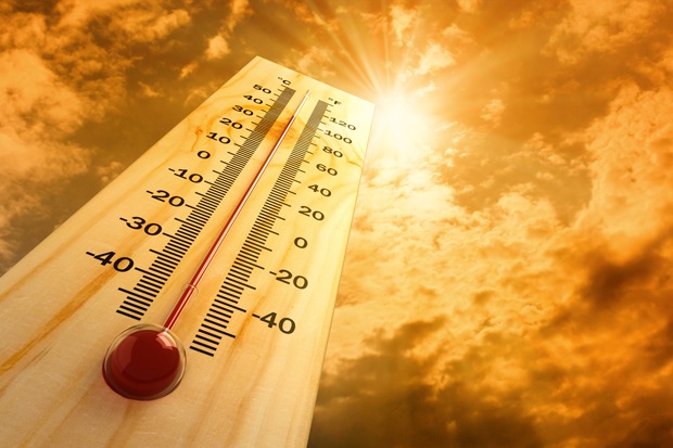
Temperatures to rise above 26°C for good / It-temperaturi se jaqbżu l-26°C għal kollox

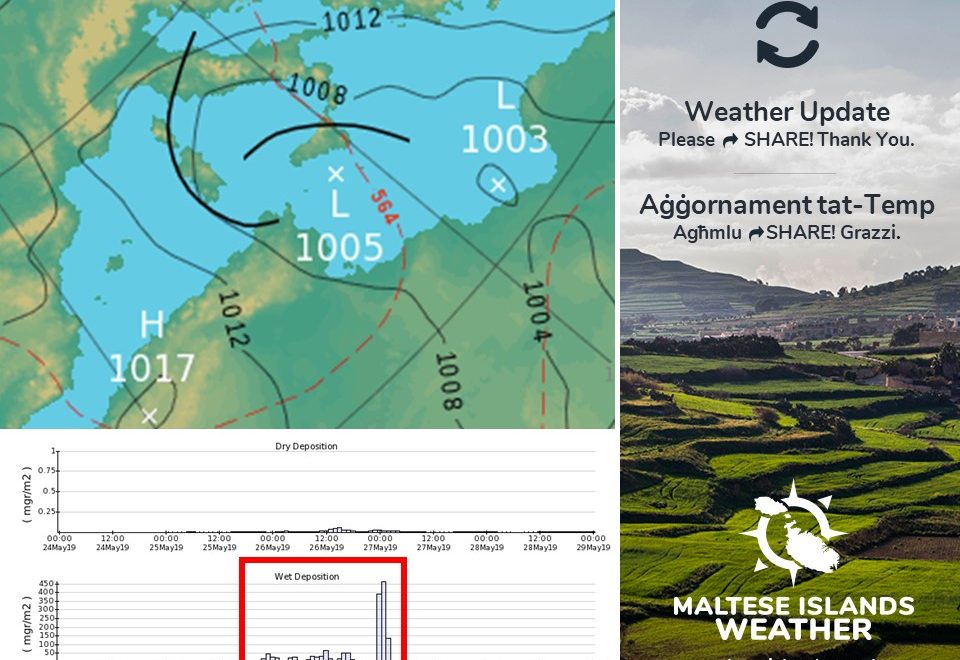
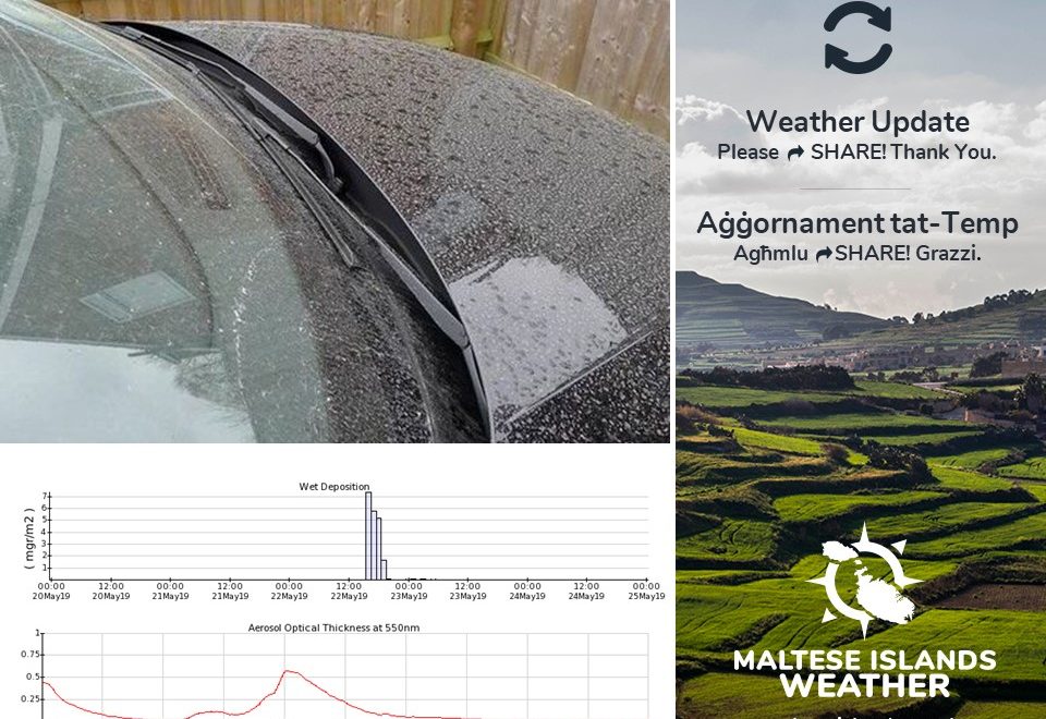
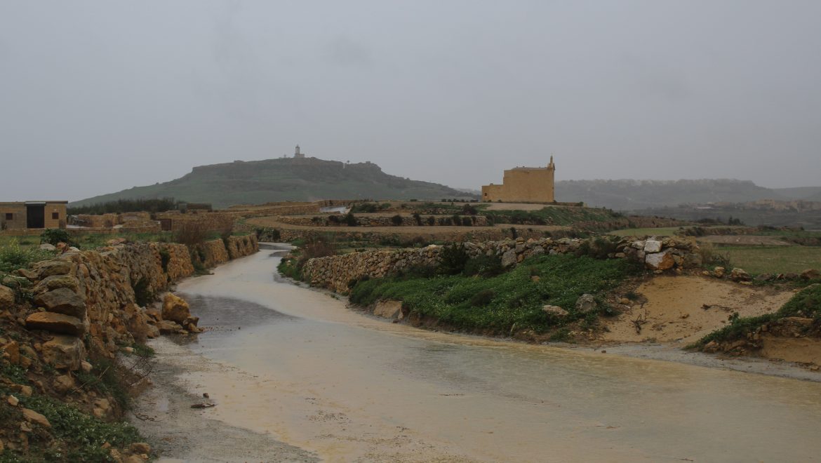
As summer edges ever closer, air currents making their way to the central Mediterranean from north Africa will become more established and prominent. Daytime highs will rise to above 26°C for good from this weekend onward, as the transition from spring to summer is now well underway. Nighttime lows will not dip below 17°C anymore. Temperatures will be at or slightly above the mean for this time of year. There will be a few more wet or windy days to come this spring, but these will be few and far between as we edge ever closer to summer. Long term charts still suggest that summer 2019 will be average or slightly warmer than average

Hekk kif is-sajf dejjem joqrob, il-kurrenti sħan li jilħqu iċ-ċentru tal-Mediterran minn l-Afrika ta’ fuq se jibdew isiru aktar stabbiliti u prominenti. Minn tmiem il-ġimgħa ‘l quddiem, l-ogħla temperaturi se jibdew jaqbżu s-26°C kuljum, hekk kif il-bidla mir-rebbiegħa għas-sajf qiegħdha fl-aqwa tagħha. It-temperaturi billejl mhux se jibqgħu jinżlu taħt l-17°C. It-temperaturi se jibdew ikunu daqs jew ftit ogħla mill-medja għal dan iż-żmien tas-sena. Se jkollna xi jiem ta’ maltemp l’hawn u l’hemm imma dawn se jkunu dejjem aktar rari hekk kif is-sajf qiegħed dejjem joqrob. L-aħħar mudelli tat-temp għadhom juru li s-sajf ta’ l-2019 għandu jkun normali jew ftit aktar sħun minn normal.

Updates

This week: Another week of mixed weather

The end of May and beginning of June is set to be marked by mixed weather conditions in the Maltese Islands. In a contrast to last week, the meteorological situation will be more stable this week. It will be off to a relatively unstable start, with a low pressure system moving easterly across the central Mediterranean. Meanwhile, a ridge of high pressure will develop over the western Mediterranean. This will be strengthening over the course of this week, ensuring a general improvement in weather conditions locally.  There will be days with a sunny sky, and others with a cloudy sky. There may be some rain on up to one day as well. A little rain is likely on Tuesday 28/05. The brightest days are expected to be Friday 31/05, Saturday 01/06 and Sunday 02/06, as the meteorological summer will be off to a bright start. Daytime highs will be on the increase throughout this week, reaching their peak of 26 C at the weekend. Nighttime lows will be more stable, dipping to 16 C/17 C on all days. The wind will be light to moderate on all days.

Looking at the meteorological situation for next week, the average daytime temperature will be around 24 C, with a high for the week of 26 C expected in the afternoon on Wednesday 29/05, Saturday 01/06 and Sunday 02/06. The mean nighttime temperature will be of 16 C. A little rain is likely early on Tuesday 28/05. The rain will be very isolated and will deposit fine desert sand. Winds are set to remain mainly light to moderate. It will be at its strongest on Tuesday 28/05 and Thursday 30/05, when the wind from the West will reach Force 4/5 at times.

Updates

Unstable weather for the weekend / Temp instabbli għal tmiem il-ġimgħa

Yet another weekend of instability for the Maltese Islands, as a low pressure system of north African origin will be moving across the central Mediterranean over the next 48 hours or so. This low pressure system will be affecting us in several ways. An extensive mass of grey cloud will cover the sky on Saturday 25/05 and Sunday 26/05. A few isolated showers are likely, and may occur at any time this weekend. Despite this, the greatest chance of rain is highest early and late on Sunday 26/05. It may be thundery at times too. Total rainfall can reach 7.5 mm in the wettest localities, but being very isolated, some parts of the Maltese Islands may remain completely dry. One cannot tell where the rain will affect though. Any rainfall will deposit an abundant amount of fine desert sand. Another effect of this low pressure system should be a strong wind from the East Southeast. The wind will increase gradually on Saturday 25/05, and will reach Force 5/6 to 6/7 from early afternoon on Saturday 25/05 till late morning on Sunday 26/05. The air will be a bit hazy at times due to airborne fine desert sand. The meteorological situation will improve greatly on Monday 26/05, despite several days with strong winds next week.

Tmiem il-ġimgħa ta’ instabilta’ ieħor għal Gżejjer Maltin, minħabba sistema ta’ pressjoni baxxa minn fuq it-tramuntana ta’ l-Afrika li se tgħaddi fuq iċ-ċentru tal-Mediterran matul it-48 siegħa li ġejja. Din is-sistema ta’ pressjoni baxxa se taffetwana f’diversi modi. Is-sema se jkun mgħotti b’massa estensiva ta’ sħab griż nhar is-Sibt 25/05 u l-Ħadd 26/05. Xi ftit ħalbiet iżolati tax-xita għandhom jaħkmuna, u se jkunu qed imissuna minn ħin għal ieħor matul tmiem il-ġimgħa. Iċ-ċans ta’ xita se jkun l-ogħla kmieni u tard nhar il-Ħadd 26/05. Tista tkun bir-ragħad ukoll minn ħin għal ieħor. It-total ta’ xita jista jilħaq is-7.5 mm fl-aktar lokalitajiet milquta, imma peress li se tkun iżolata ħafna, xi nħawi tal-Gżejjer Maltin jistgħu jibqgħu nexfin għal kollox. Ma tistax tgħid eżatt fejn se tmiss din ix-xita. Ix-xita se tkun tal-ħamrija. Effett ieħor ta’ din il-pressjoni baxxa se jkun riħ qawwi mix-Xlokk il-Lvant. Ir-riħ se jkun qed iżid bilmod matul is-Sibt 25/05, u se jilħaq Forza 5/6 għal 6/7 minn kmieni wara nofsinhar tas-Sibt 25/05 u tard filgħodu tal-Ħadd 26/05. L-arja se tkun imdaħħna kultant minħabba trab fin fl-arja. Is-sitwazzjoni tat-temp se taqleb għal aħjar it-Tnejn 26/05, minkejja li se jkollna numru ta’ ġranet b’riħ qawwi matul il-ġimgħa li ġejja.

Updates

Dusty rain again / Nerġgħu bix-xita tal-ħamrija

A trough of low pressure is expected to emerge from Libya on Wednesday 22/05. This will move across the central Mediterranean and may affect the Maltese Islands as it does so. Its main impact on the Maltese Islands will be the chance of isolated showers on Wednesday 22/05. Being of north African origin, any rain will deposit fine desert sand. Accumulations should not exceed 2.5 mm, and many localities may remain completely dry. The sky will be overcast throughout the day and the wind will be mainly light and variable. An improvement in weather conditions is expected on Thursday 23/05, but instability will return on Saturday 24/05, as rain is still expected to affect the Maltese Islands this weekend.

Roqgħa ta’ pressjoni baxxa se titla minn fuq il-Libja nhar il-Erbgħa 22/05. Din se tkun qed tgħaddi minn fuq iċ-ċentru tal-Mediterran u għalhekk tista taffetwa lil Gżejjer Maltin. L-impatt prinċipali ta’ din se jkun iċ-ċans ta’ ħalbiet iżolati tax-xita nhar l-Erbgħa 22/05. Peress li din il-pressjoni baxxa se tkun ta’ oriġini Linjaba, ix-xita se tkun tal-ħamrija. It-total ta’ xita ma għandux jaqbeż it-2.5 mm, bil-maġġoranza tal-lokalitajiet mistennija jibqgħu nexfin. Is-sema se jkun imsaħħab matul il-jum u r-riħ se jkun il-biċċa l-kbira ħafif u varjabbli. It-temp għandu jaqleb il-Ħamis 23/05, imma l-maltemp jirritorna s-Sibt 24/05, hekk kif għadha mistennija x-xita matul it-tmiem il-ġimgħa li ġej.

Updates

This week: Another week with mixed weather

Another week of mixed weather conditions is on the cards for the Maltese Islands, as spring remains far out of sight this year. The central Mediterranean continues to find itself caught up in between high and low pressure. By this time of year, high pressure would normally have a tight grip on the Maltese Islands. There will be days with a sunny sky, and others with a cloudy sky. There may be some rain on up to three days as well. Rain is most likely on Wednesday 22/05, Saturday 25/05 and Sunday 26/05. The brightest days are expected to be Tuesday 21/05, Thursday 23/05 and Friday 24/05. Daytime highs will be on the increase in the first half of the week, reaching their peak on Wednesday 22/05, with a maximum temperature of 25 C. They will decrease again over the course of the second half of the week, struggling to reach 21 C on Sunday 26/05. Nighttime lows will be more stable, dipping to 15 C/16 C on all days. The wind will be light to moderate on all days.

Looking at the meteorological situation for next week, the average daytime temperature will be around 23 C, with a high for the week of 25 C expected in the afternoon on Wednesday 22/05. The mean nighttime temperature will be of 15 C, dipping to its lowest early in the morning of Tuesday 21/05 at 14 C. Showers are likely on Wednesday 22/05, Saturday 25/05 and Sunday 26/05. The latter two are expected to be the wettest days of the week, with a possible accumulation of 10 mm. On the whole winds are expected to be light to moderate. The wind will be at its strongest on Friday 24/05 and Saturday 25/05, when the wind from the Northwest will reach Force 4/5 at times.

Updates

Rainy last weekend of May? / Xita għal aħħar tmiem il-ġimgħa ta’ Mejju?

Several weather models are predicting a rainy last weekend of May. It’s still too early to be sure, but a growing number of weather models are suggesting this. What we know for sure is that a low pressure system will be moving across the central Mediterranean on Saturday 25/05. If this prediction prevails, expect rain from late on Friday 24/05 till early on Sunday 26/05. Apart from this, one is to expect strong winds and cool temperatures next weekend. This year’s spring has been the poorest in many years.

Numru ta’ mudelli tat-temp qed ibassru xita għal aħħar tmiem il-ġimgħa ta’ Mejju. Għadu kmieni biex inkunu nafu biċ-ċert, pero’ n-numru ta’ mudelli li qed jgħidu qiegħed iżid. Li nafu biċ-ċert hu li sistema ta’ pressjoni baxxa se tkun għaddejja minn fuq iċ-ċentru tal-Mediterran nhar is-Sibt 25/05. Jekk dan it-tbassir jibqa kif inhu, stennew xita minn tard il-Ġimgħa 24/05 sa kmieni l-Ħadd 26/05. Apparti minn hekk, għandna nistennew temperaturi friski ferm u riħ qawwi għal tmiem il-ġimgħa li jmiss. Din ir-rebbiegħa kienet l-aktar fqira f’ħafna snin.

Updates

Temperatures to rise above 24°C for good / It-temperaturi se jaqbżu l-24°C għal kollox

After a couple of unstable days, air currents making their way to the central Mediterranean from north Africa will be restored. Daytime highs are expected to rise above 24°C for good, as the transition from spring to summer starts. Nighttime lows will not dip below 15°C anymore. Temperatures will be at or slightly above the mean for this time of year. There will be a few more wet or windy days to come this spring, but these will be few and far between as we edge ever closer to summer. Long term charts still suggest that summer 2019 will be hotter than average.

Wara numru ta’ jiem b’temp instabbli, jidher li l-kurrenti sħan li jilħqu iċ-ċentru tal-Mediterran minn l-Afrika ta’ fuq se jerġgħu jieħdu posthom. L-ogħla temperaturi se jibdew jaqbżu l-20°C kuljum, hekk kif il-bidla mir-rebbiegħa għas-sajf se tibda. It-temperaturi billejl mhux se jibqgħu jinżlu taħt l-15°C. It-temperaturi se jibdew ikunu daqs jew ftit ogħla mill-medja għal dan iż-żmien tas-sena. Se jkollna xi jiem ta’ maltemp l’hawn u l’hemm imma dawn se jkunu dejjem aktar rari hekk kif is-sajf joqrob. L-aħħar mudelli tat-temp għadhom juru li s-sajf ta’ l-2019 għandu jkun sħun aktar mill-medja.

Updates

Weather till the end of May / It-temp sa l-aħħar ta’ Mejju

What’s the weather going to be like for the rest of May? Will it ever settle down? Long-term weather maps indicate that the temperature will be on the increase again from Friday 17/05 onward. Daytime highs will reach 24 C by Monday 20/05. From then on, they will remain at or above 24 C for good. That means that temperatures will now be at or slightly above the mean for this time of year. Nighttime lows will also warm up, consistently staying at or above 15 C from Monday 20/05. On the other hand, rainfall events will become few and far in between. This means that with regards to temperature and rainfall, the weather will be settling down. We cannot say the same for the wind, however. The Maltese Islands are set to continue finding themselves sandwiched in between high and low pressure. This implies more days than normal with wind speeds at Force 4/5 or stronger. The Northwest will be the most common wind direction.

In conclusion, the meteorological situation is expected to settle down. Temperatures will now be at or slightly above the mean. Sunny or mainly sunny skies will dominate most days. There will be several days with a strong breeze from the Northwest though.


Kif se jkun it-temp għal bqija ta’ Mejju? Jidher li se joqgħod daqsxejn? Mudelli li juruna kif se jkun it-temp ‘il quddiem qed jindikaw li t-temperaturi se jerġgħu jibdew jiżdiedu minn nhar il-Ġimgħa 17/05 ‘il quddiem. L-ogħla matul il-jum se tilħaq 24 C minn nhar it-Tnejn 20/05. Minn dakinhar ‘il quddiem, it-temperaturi mistennija li jżommu f’dak il-livell jew aktar. Dan ifisser li t-temperaturi se jibdew ikunu mal-medja jew ogħla mill-medja għal dan iż-żmien tas-sena. It-temperaturi ta’ billejl se jisħnu wkoll, u se jibdew iżommu minn 15 C ‘il fuq. Jekk nagħtu ħarsa lejn episodji ta’ xita, jidher li dawn se jsiru aktar rari. Dan jimplika li fejn jidħlu temperaturi u xita, it-temp mistenni li joqgħod. Ma nistgħux ngħidu l-istess għar riħ, pero’. Il-Gżejjer Maltin se jibqgħu jsibu ruħhom bejn arja bi pressjoni għolja u arja bi pressjoni baxxa. Minħabba dan, se jibqa jkollna numru ta’ jiem b’riħ ta’ Forza 4/5 jew aktar. Ir-riħ se jkun il-biċċa l-kbira mill-Majjistral.

Biex nikkonkludu, is-sitwazzjoni metejoroloġika se tkun qed taqleb għal aħjar. It-temperaturi se jkun mal-medja jew ftit ogħla. Is-sema se jibda jkun xemxi jew il-biċċa l-kbira xemxi f’bosta jiem. Se jkun hemm numru ta’ jiem b’riħ li jaf ikun qawwi mill-Majjistral pero’.

Updates

Overnight thunderstorm / Maltempata bir-ragħad billejl

The center of a low pressure system will be moving across southern Italy over the next couple of hours. A major thunderstorm will affect Sicily as a result of this. The Maltese Islands are set to be affected by only the edge of this thunderstorm. As a result, rain that may be heavy, thundery and with hail may affect the Maltese Islands. The chance of rain is highest from midnight till 09:00 on Thursday 16/05. There will be no severe weather. The rain will be clean. Total precipitation accumulations may exceed 10 mm in hardest-hit localities. Gozo is expected to be the most affected by this. The sky will become mainly sunny during the day on Thursday 16/05. The West wind will increase to Force 6/7 though.

Iċ-ċentru ta’ sistema ta’ pressjoni baxxa se jgħaddi minn fuq in-nofsinhar ta’ l-Italja fis-siegħat li ġejjin. Maltempata bir-ragħad qawwija għandha taħkem lil Sqallija minħabba dan. Il-Gżejjer Maltin se jkunu affetwati biss minn tarf din il-maltempata. Għalhekk, xita li tista tkun qawwija, bir-ragħad u bis-silġ tista taffetwa lil Gżejjer Maltin. Iċ-ċans ta’ xita jkun l-ogħla minn nofsillejl sa 09:00 tal-Ħamis 16/05 polska-ed.com. Mhux se jaħkimna maltemp sever. Ix-xita se tkun nadifa. It-total ta’ xita jaf jilħaq 10 mm fil-lokalitajiet l-aktar milquta. Għawdex għandu jintlaqat l-aktar minn din. Is-sema se jsir il-biċċa l-kbira xemxi matul il-jum tal-Ħamis 16/05. Ir-riħ se jkun ta’ Forza 6/7 mill-Punent pero.

Updates

This week: Unstable weather to dominate

A low pressure system over central Italy will prevail for much of this week, bringing with it unstable weather conditions to the central Mediterranean. During the coming weekend, the Maltese Islands will find themselves sandwiched between a ridge of high pressure over the eastern Mediterranean and low pressure to our west. This meteorological situation will bring moderate to strong winds from the West Northwest, partly to variably cloudy skies with the possibility of isolated showers from time to time and below average temperatures till Friday 17/05. Isolated showers are most likely from late on Monday 13/05 till early on Tuesday 14/05 and early on Thursday 16/05. Daytime highs will struggle to reach 21 C, with nighttime lows dipping to a cool 13 C. The meteorological situation will improve slightly at the weekend, with temperatures expected to rise gradually from 22 C on Friday 17/05 to 26 C on Sunday 19/05. It will remain partly to variably cloudy and rather windy though.

Looking at the meteorological situation for next week, the average daytime temperature will be around 22 C, with a high for the week of 26 C expected in the afternoon on Sunday 19/05. The mean nighttime temperature will be of 14 C, dipping to its lowest early in the morning of Monday 13/05 and Tuesday 14/05 at 13 C. Isolated showers are likely from late on Monday 13/05 till early on Tuesday 14/05 and early on Thursday 16/05. The latter is expected to be the wettest day of the week, with a possible accumulation of 10 mm. On the whole winds are expected to be moderate to strong. The wind will be at its strongest on Monday 13/05, when the wind from the West will reach Force 5/6 at times.