Updates

For the latest updates related to the weather in the Maltese Islands. So keep yourself updated by visiting this page frequently or like our Facebook page.

Updates

Answering your most frequently asked questions

In this post, we will be answering some of your most frequently asked questions about the current meteorological situation:

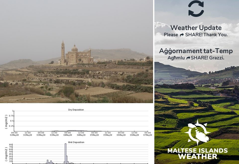
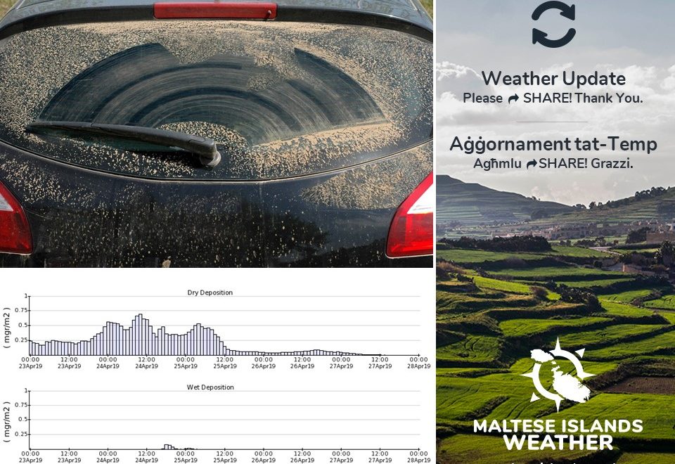
1) Some facts about spring till now:

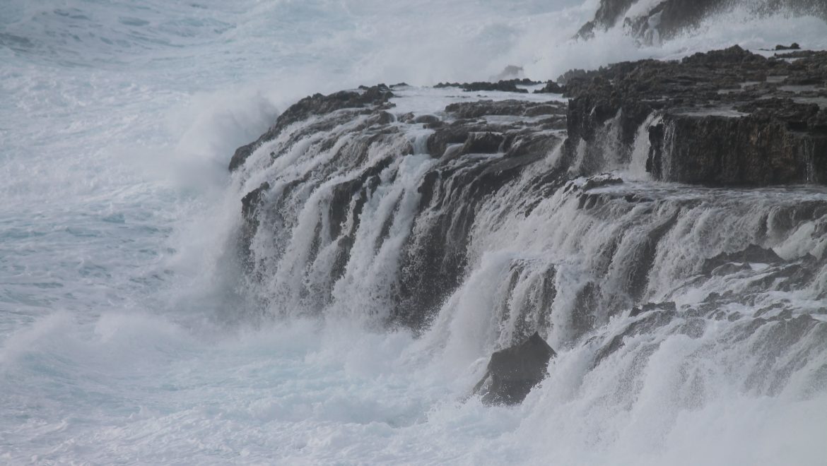
If you’ve felt that this year’s spring has so far been colder and wetter, you’re absolutely right! In a typical year, from 21st March till 12th May, the Maltese Islands would receive 41.7 mm of rainfall. This year, from 21st March till 12th May, 90.8 mm were measured at our weather station in Għarb. Over the same time frame, the Maltese Islands would normally enjoy highs of 20.3 C and lows of 13.0 C. So far this spring, our weather station has recorded a mean high of 18.6 C and an average low of 12.6 C. Another very important point to note is the increased frequency of days with strong winds.

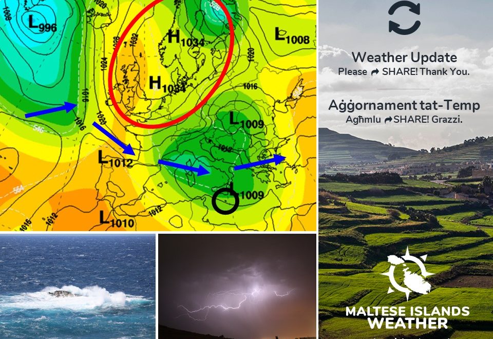
2) What is causing it?

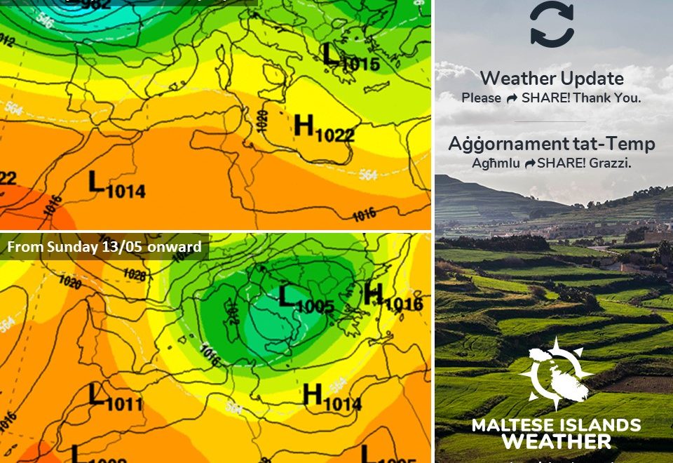
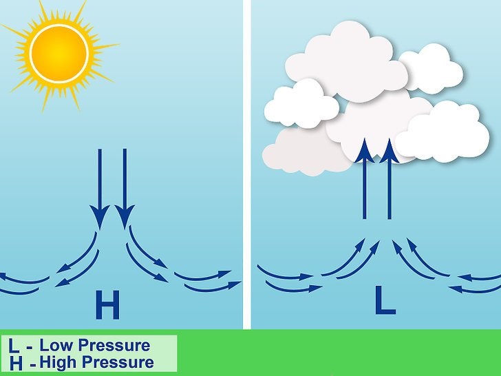
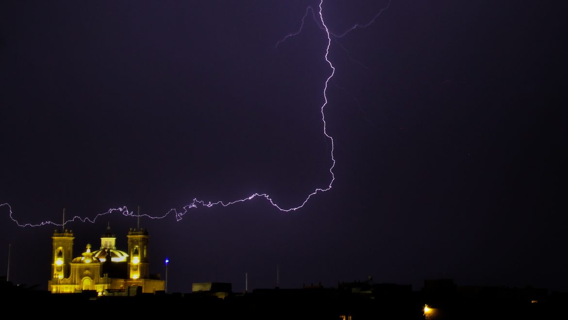
As seen on the chart, a high pressure system covers much of northern Europe. This anomalous high pressure system has been anchored over Scandinavia for weeks. This anticyclone acts as a barrier, preventing storm systems from moving across northern Europe, and deviating them south towards southern Europe. This is also encouraging more low pressure systems to form over north Africa than usual. For the Maltese Islands this implies unstable weather, with a mix of desert and northern European weather, unlike the usual gradual improvement in weather conditions we normally experience in spring.

4) What are the projections for the near future?

Of course, spring has many weeks to go, and the meteorological situation may improve. Long term maps do not provide a very bright outlook, however. Temperatures are expected to rise in the second half of May, but strong winds and the occasional rainy day will continue to be a common feature for the rest of spring, and possibly also the start of summer. As explained in an update some days ago, this year’s summer is expected to be hotter but wetter than normal. We will have a clearer picture in the days ahead.

If you have any other questions please write these as comments below and we will answer them. Thanks!

Updates

More instability ahead / Aktar instabbilta’ fil-ġejjieni

A high pressure system extending across the central Mediterranean will drag very warm air from north Africa towards the Maltese Islands. For up to three days, the air temperature across the Maltese Islands will be at or above average. Temperatures will reach 22 C, 25 C and 26 C on Thursday 09/05, Friday 10/05 and Saturday 11/05 respectively. This warm spell will be short-lived, however, as a low pressure system developing over the Gulf of Genoa reaches the central Mediterranean on Sunday 12/05. This will drive colder air from over Europe towards the central Mediterranean. Temperatures will plunge to below average once again. Highs will struggle to reach 21 C / 22 C during the day, and will dip to 13 C / 14 C at night. The Northwest wind will once again blow strongly across our area of the Mediterranean next week. The skies will also be cloudier, with some light rain possible on a couple of days. Starting on Sunday 12/05, this instability is expected to take hold of the Maltese Islands till at least Friday 17/05.

Sistema ta’ pressjoni għolja li qed testendi fuq iċ-ċentru tal-Mediterran se tkun qed iġġib magħha arja sħuna minn fuq l-Afrika lejn il-Gżejjer Maltin. Għal xi tlett ijiem, it-temperaturi fil-Gżejjer Maltin se jkunu mal-medja jew ogħla. It-temperaturi mistennija jilħqu 22 C, 25 C u 26 C nhar il-Ħamis 09/05, il-Ġimgħa 10/05 u s-Sibt 11/05 rispettivament. Din il-waqfa ta’ temperaturi sħan se tkun qasira ħafna, pero, hekk kif sistema ta’ pressjoni baxxa li qed tifforma fuq il-Golf ta’ Genoa se tgħaddi lejn iċ-ċentru tal-Mediterran. It-temperaturi se jaqgħu għal taħt il-medja mill-ġdid. L-ogħla se jilħqu biss 21 C / 22 C matul il-jum, filwaqt li jinżlu sa 13 C /14 C billejl. Ir-riħ mill-Majjistral se jerġa jkun qawwi fir-reġjun tagħna tal-Mediterran. Is-sema se jkun aktar imsaħħab, b’saħansitra xi ftit xita ħafifa tkun possibli f’numru ta’ jiem. Din l-instabbilta’ se tibda nhar il-Ħadd 12/05, u mistenni tkompli għaddejha sa mill-anqas il-Ġimgħa 17/05.

Updates

A windy spring! / Rebbiegħa mirjieħa!

I think we can all agree that this spring has been characterised by frequent strong winds. It was windy a few days ago. It will be windy again over the weekend. But why? It’s simple! Changes in air pressure and temperature usually start and maintain wind. Generated by differential heating of the Earth’s surface, pressure differences may develop on all scales, from local to global. Warm air is less dense than cold air and tends to rise, reducing the number of air molecules at ground level. This leaves behind a mass deficit, or an area of low pressure. As air cools, it sinks, and the number of air molecules at the Earth’s surface increases, forming what we refer to as a region of high pressure. To balance the difference, air flows from high to low pressure, creating wind. This spring, the Maltese Islands are finding themselves sandwiched in between low and high pressure more often than usual. Therefore, this spring has been windier.


Naħseb li lkoll nistgħu naqblu li din ir-rebbiegħa kienet ikkarateriżżata minn riħ qawwi frekwenti. Kien mirjieħ xi jiem ilu. Se jerġa jkun mirjieħ fi tmiem il-ġimgħa. Għalfejn? Ir-riħ ġeneralment jifforma minn differenzi fil-pressjoni ta’ l-arja u temperaturi. Minħabba li x-xemx ma taħkimx il wiċċ tad-dinja b’mod ugwali kullimkien, jeżistu irqajja ta’ pressjoni atmosferika differenti, kemm lokali, kif ukoll fuq skala globali https://southafrica-ed.com/kamagra-in-south-africa/. Arja sħuna hija anqas dens minn arja kiesħa u għalhekk titla l-fuq, biex b’hekk ikun hemm anqas arja qrib l-art. Dan iħalli warajh dik li nsejħula pressjoni baxxa. Arja kiesħa hija aktar dense minn arja sħuna u għalhekk tinżel l-isfel, biex b’hekk ikun hemm aktar arja qrib l-art. Dan iħalli warajh dik li nsejħula pressjoni għolja. Biex jibbilanċjaw dawn id-differenxi, l-arja timxi minn żoni ta’ pressjoni għolja għal żoni ta’ pressjoni baxxa. Din l-arja miexja hija r-riħ. F’din ir-rebbiegħa, il-Gżejjer Maltin sabu ruħhom maqbudin bejn sistemi ta’ pressjoni baxxa u rqajja ta’ pressjoni għolja ferm aktar mis-solt. Għalhekk, din ir-rebbiegħa kienet aktar mirjieħa.

Updates

This week: Improving weather

The meteorological situation will be improving gradually over the course of this week. This week will be off to an unstable as a weak cold front traverses across the central Mediterranean in the early hours of Monday 06/05. This cold front may bring a little rain in the early hours of the day. It will also maintain the strong wind from the West Northwest. With a 19 C high and 13 C low, Monday will be the coldest day this week. The strong wind will make it feel colder. A ridge of high pressure will cover the central Mediterranean from early on Tuesday 07/05, marking the return of fine weather to the Maltese Islands. The weather on Tuesday and Wednesday 08/05 will be brilliant. A weak trough of low pressure will pass through our region on Thursday 09/05, bringing us partly to variably skies, and perhaps a bit of rain. From Friday 10/05 till Sunday 12/05, the Maltese Islands will find themselves at the edge of a ridge of high pressure. This means mainly sunny skies, but with the possibility of a strong breeze at the weekend. A low pressure system over the south of Italy will be drawing warm currents from the Sahara Desert towards the central Mediterranean, causing air temperatures to rise https://southafrica-ed.com/kamagra-in-south-africa/. With a high of 26 C and 17 C low, Saturday will be the warmest day of the week. No significant precipitation is anticipated for this week.


Updates

Here comes the Northwest wind! / Ara ġej ir-riħ mill-Majjistral!

After airborne fine desert sand, dirty rain and a strong southeasterly wind, a breathe of fresh air is set to reach the Maltese Islands from late on Saturday 04/05 onward. A low pressure system over the central Mediterranean will be moving eastwards, with a ridge of high pressure taking hold of the western Mediterranean. This difference in pressure will generate a strong northwesterly air flow across our region. The wind turns Northwest in the evening on Saturday 04/05, and will prevail till Tuesday 07/05. It could reach Force 6/7 at times. This wind will clear the air from fine desert sand and cause temperatures to dip slightly. There is also the chance for some light rain late on Sunday 05/05. The rain will be clean.

Wara ramel fin fl-arja, xita tal-ħamrija u riħ qawwi mix-Xlokk, il-Gżejjer Maltin se jkun affetwati minn arja frisk li għandha tilħaqna minn tard is-Sibt 04/05 ‘il quddiem. Sistema ta’ pressjoni baxxa fuq iċ-ċentru tal-Mediterran se tersaq lejn il-Lvant, filwaqt li firxa ta’ pressjoni għolja mistennija tifforma fuq il-punent tal-Mediterran. Din id-differenza fi pressjoni atmosferika se twassal għal riħ qawwi mill-Majjistral. Ir-riħ se jdur Majjistral is-Sibt 04/05 filgħaxija, u jippersisti sa nhar it-Tlieta 07/05. Jaf jilħaq Forza 6/7 kultant. Ir-riħ se jġib miegħu arja nadifa u friska. Hemm iċ-ċans ta’ ftit xita ħafifa tard il-Ħadd 05/05. Din ix-xita tkun nadifa.

Updates

Thunderstorms at night? / Maltempati bir-ragħad billejl?

Exactly as forecast, a low pressure system rising from north Africa will be traversing the central Mediterranean till late on Saturday 04/05. Apart from the strong Southeast wind, airborne fine desert sand and dusty rain, there may be some isolated thunderstorms. This is the result of the warm air rising with the low pressure system from north Africa clashing with colder air extending south from Europe. Isolated thunderstorms will develop across the central Mediterranean overnight, potentially affecting the Maltese Islands in the process. Light rain is possible at anytime, whilst isolated thunderstorms are possible from 21:00 on Friday 03/05 till 09:00 on Saturday 04/05. During any isolated thunderstorms, if at all, the rain may be briefly heavy. Totals of up to 10 mm are possible across parts of the Maltese Islands. The Southeast wind will be at its strongest overnight, when it should reach Force 8 at times. Brighter skies will return to the Maltese Islands later in the day on Saturday 04/05, when the strong wind turns Northwest.

Eżatt kif imbassar, sistema ta’ pressjoni baxxa tiela minn l-Afrika ta’ fuq se tkun qed tgħaddi minn fuq iċ-ċentru tal-Mediterran sa tard is-Sibt 04/05. Minbarra riħ qawwi mix-Xlokk, ramel fl-arja u xita tal-ħamrija, jaf ikun hemm xi maltempati bir-ragħad iżolati. Dan huwa r-riżultat ta’ kuntrast bejn arja sħuna li tiela ma’ din il-pressjoni baxxa minn l-Afrika ta’ fuq u arja aktar kiesħa nieżla minn fuq l-Ewropa. Maltempati bir-ragħad iżolati se jiffurmaw madwar iċ-ċentru tal-Mediterran billejl, u xi wħud jistgħu jaffetwaw lil Gżejjer Maltin. Xita ħafifa hija possibli minn ħin għal-ieħor, filwaqt li ċ-ċans ta’ maltempati bir-ragħad iżolati se jkun l-ogħla minn 21:00 tal-Ġimgħa 03/05 sa 09:00 tas-Sibt 04/05. Matul il-maltempati bir-ragħad iżolati, jekk jaħkmuna, ix-xita taf tkun qawwija għal ftit ħin. Ammonti ta’ 10 mm huma possibli f’xi nħawi. Ir-riħ mix-Xlokk se jkun l-aktar qawwi billejl, meta dan għandu jilħaq Forza 8. Sema kaħlani se jerġa jkun magħna tard is-Sibt 04/05, meta r-riħ idur Majjistral.

Updates

The return of Sahara Desert weather / Ir-ritorn ta’ temp mid-deżert tas-Sahara

Spring in the Maltese Islands is synonymous with occasional outbreaks of Sahara Desert weather. This often entails strong southerly winds, airborne fine desert sand and dirty rain. Another outbreak of this depressing weather is expected over the Maltese Islands from early on Friday 03/05 till late on Saturday 04/05. Once again, this will be caused by a low pressure system traversing north Africa. It will bring with it abundant fine desert sand. This will peak early in the morning on Saturday 04/05. The sky will glow red (especially at night) as a result of this. Some isolated showers, possibly briefly thundery at times, should affect parts of the Maltese Islands on both days. The greatest chance of rain is in the morning on Saturday 04/05. Up to 10 mm of rain may be measured in hardest hit localities. Any rain will deposit fine desert sand. The East wind will reach Force 6/7 at times on both days. This state of affairs will prevail till late on Saturday 04/05, when a strong Northwest wind will blow all the sand away. Sunny skies resume on Sunday 05/05.

Ir-rebbiegħa fil-Gżejjer Maltin hija sinonima ma’ mewġ ta’ temp minn fuq id-Deżert tas-Sahara. Dan normalment iġib miegħu rjiħat qawwija minn Nofsinhar, ramel fin mid-deżert fl-arja u xita tal-ħamrija. Mewġa oħra ta’ dan it-temp dipressanti għandha taħkimna minn kmieni l-Ġimgħa 03/05 sa tard is-Sibt 04/05. Għal darb’oħra, din se tiġi ikkawżata minn sistema ta’ pressjoni baxxa li se tgħaddi minn naħa ta’ fuq ta’ l-Afrika. Se ġġib magħha ammont abbundanti ta’ ramel fin. Dan jilħaq l-aqwa tiegħu s-Sibt 04/05 filgħodu. Is-sema se jkun aħmar (speċjalment billejl) minħabba dan. Xi ħalbiet iżolati tax-xita, possibilment bir-ragħad għal ftit ħin, se tkun qed taffetwa ċertu nħawi tal-Gżejjer Maltin fil-jumejn li huma. Ix-xita tkun l-aktar possibli is-Sibt 04/05 filgħodu. Xi 10 mm ta’ xita jistgħu jiġu osservati fl-aktar lokalitajiet milquta. Ix-xita se tkun tal-ħamrija. Ir-riħ mill-Lvant se jilħaq Forza 6/7 kultant. Dan it-temp mistenni li jżomm sa tard is-Sibt 04/05, meta ir-riħ idur Majjistral u jnaddaf l-arja ta’ madwarna. Is-sema jerġa jkun xemxi l-Ħadd 05/05.

Updates

3 Hourly Forecast for Workers’ Day (01/05/2019)

00:00 to 03:00 – increasing cloudiness; 15 C to 14 C; West Force 2/3
03:00 to 06:00 – isolated showers; 14 C to 13 C; West to West Southwest Force 2/3
06:00 to 09:00 – decreasing cloudiness; 13 C to 17 C; West Southwest Force 2/3
09:00 to 12:00 – sunny; 17 C to 20 C; West Southwest to West Northwest Force 2/3
12:00 to 15:00 – sunny; 20 C to 19 C; West Northwest Force 2/3
15:00 to 18:00 – sunny; 19 C to 17 C; West Northwest to Northwest Force 2/3
18:00 to 21:00 – clear; 17 C to 15 C; Northwest to North Northwest Force 2/3
21:00 to 00:00 – clear; 15 C to 13 C; North Northwest Force 2/3

Worker’s Day (or Labour Day) is an annual holiday celebrated all over the world, recognising the economic and social achievements of workers. Popularly known as May Day or International Workers’ Day, the 1st of May is also a public holiday in Malta and Gozo. It also marks the legal establishment of the eight-hour working day. The date also coincides with the religious feast of St. Joseph the Worker celebrated in the town of B’Kara. It is also 15 years since Malta joined the European Union.

Updates

This week: Mixed weather ahead

A week of mixed weather conditions lies ahead for the Maltese Islands. Some days will enjoy uninterrupted bright sunshine. Other days will bring clouds that could produce some isolated showers. It will also be quite windy on some days, particularly over the weekend. Nevertheless, daytime highs will not drop below 20°C, as the transition from winter to summer continues. Taking a look at the weather across the Maltese Islands over the coming week, the average maximum temperature will be around 21°C, . The average minimum temperature will be 14°C. Temperatures will be at the average for this time of year throughout the week. Nighttime lows could feel cooler, as a result of wind. With a daytime high of 22°C, Thursday 02/05 and Sunday 05/05 will be the warmest.  The wind will be from the West Northwest on most days, save for Friday 03/05, when a strong wind from the Southeast affects us. The West Northwest wind will blow strongly over the weekend too brasil-libido.com. Some rain is possible. We expect some light rain during the night from Tuesday 30/04 to Wednesday 01/05. Showers will also be possible during the night from Friday 03/05 to Saturday 04/05. Total rainfall amounts will not be high, with some localities expected to remain dry.

Updates

How long until the fine desert sand is gone? / Kemm baqalna bir-ramel fin mid-deżert?

A blanket of fine desert sand has choked the Maltese Islands over the past few days. An abundant amount of this was also deposited with the light rain on Monday 22/04. With a high of 27 C, Tuesday 23/04 was also the warmest day so far this year. How long until the fine desert sand moves away from the central Mediterranean? The fine desert sand will continue to be present in abundant amounts till around midday on Thursday 25/04. Further light rain is set to deposit the fine desert sand late on Wednesday 24/04. Washing your vehicles and windows, therefore, continues to be inadvisable. A change in the meteorological situation after midday on Thursday 25/04 will mean that the fine desert sand moves away from our region. This will mean the return of blue skies and clean air to the Maltese Islands. You are advised to wait until Friday 26/04 to clean your vehicles and windows.

Sħaba ta’ ramel fin minn fuq id-deżert ilha tgħatti l-Gżejjer Maltin għal dawn l-aħħar jiem. Ammont abbundanti ta’ dan ġie depożitat max-xita ħafifa tat-Tnejn 22/04. B’temperatura massima ta’ 27 C, it-Tlieta 23/04 kienet l-aktar ġurnata sħuna sa issa din is-sena. Kemm baqalna biex dan it-temp iħalli ċ-ċentru tal-Mediterran? Ir-ramel fin fl-arja se jippersisti f’ammonti abbundanti sa madwar nofs il-jum tal-Ħamis 25/04. Aktar xita ħafifa mistennija tkompli tiddepożita dan ir-ramel fin tard l-Erbgħa 24/04. Għalhekk, aħna navżawkom li ma jaqblilkomx taħslu l-vetturi u twieqi għalissa. Bidla fis-sitwazzjoni metejoroloġika wara nofsinhar tal-Ħamis 25/04 se jfisser li r-ramel fin fl-arja se jersaq lil hinn mir-reġjun tagħna. Dan ifisser ir-ritorn ta’ sema kaħlani u arja nadifa għal Gżejjer Maltin. Aħna navzawkom li jaqblilkom tistennew sal-Ġimgħa 26/04 biex tnaddfu l-vetturi u t-twieqi.