Updates

For the latest updates related to the weather in the Maltese Islands. So keep yourself updated by visiting this page frequently or like our Facebook page.

Updates

This week: Wintry weather comes to an end

The weather this week will remain fairly unstable, as the Maltese Islands continue to find themselves caught up in between pressure systems. This will lead to strong winds on most days and partly to variably cloudy skies with the possibility of some light rain till midweek. The second half of this week will be brighter. Air currents from north Africa will finally start making their way to the central Mediterranean. This will mark the definite end of wintry weather. Daytime highs are expected to rise above 20°C for good, as the transition from winter to summer continues. With a maximum temperature of 27°C, Tuesday 23/04 will be the warmest day of 2019 so far. Temperatures will be at the average for this time of year on all other days. The wind will be from the East till the weekend, before veering Northwest. The wind will reach Force 5/6 at some point on most days. Some light rain or drizzle is mainly possible on Monday, Wednesday and Thursday. Any rain will deposit fine desert sand.

Taking a look at the weather across the Maltese Islands over the coming week, the average maximum temperature will be around 23°C, with a high for the week peaking at 27°C on Tuesday 23/04. The average minimum temperature will be 16°C, dipping to its lowest of 14°C on Monday 22/04.

Updates

Temperatures to rise above 20°C for good / It-temperaturi se jaqbżu l-20°C għal kollox

Air currents from north Africa will finally start making their way to the central Mediterranean. This will mark the definite end of wintry weather. Daytime highs are expected to rise above 20°C for good, as the transition from winter to summer continues. With a maximum temperature of 27°C, Tuesday 23/04 will be the warmest day of 2019 so far. Temperatures will be at the average for this time of year on all other days. There will be more wet or windy days to come this spring, but these will be few and far between as we edge ever closer to summer. Long term charts suggest that summer 2019 will be hotter than average, especially in its first half.

Kurrenti ta’ arja minn fuq l-Afrika ta’ fuq mistennija jibdew jilħqu ċ-ċentru tal-Mediterran minn din il-ġimgħa. Din se timmarka t-tmiem definittiv tat-temp xitwi. L-ogħla temperaturi se jibdew jaqbżu l-20°C kuljum, hekk kif il-bidla mix-xitwa għas sajf sa fl-aħħar nistgħu ngħidu li bdiet. Bl-ogħla ta’ 27°C, nhar it-Tlieta 23/04 għandha tkun l-aktar ġurnata sħuna ta’ 2019 sa issa. It-temperaturi għandhom ikun mal-medja għal dan iż-żmien tas-sena fil-jiem l-oħra. Se jkun hemm xi aktar jiem ta’ xita jew riħ matul ir-rebbiegħa, imma dawn se jkunu dejjem aktar rari hekk is-sajf joqrob aktar. L-aħħar mappep tat-temp juru li s-sajf ta’ l-2019 għandu jkun sħun aktar mill-medja, speċjalment fl-ewwel nofs tiegħu.

Updates

SEVERE GALE-FORCE WIND WARNING / TWISSIJA TA’ RIEFNU QAWWI ĦAFNA

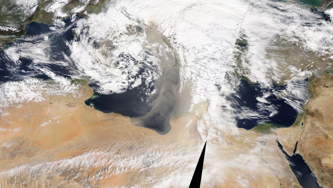
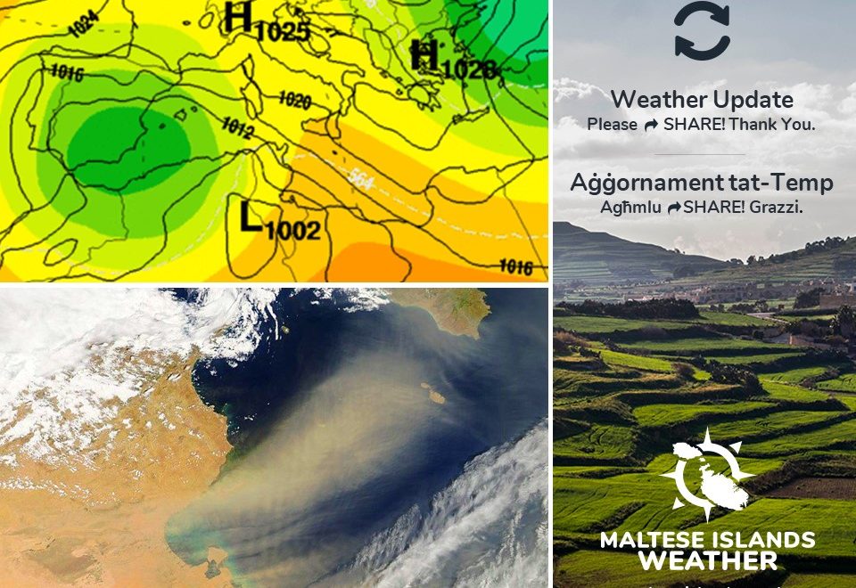
The term Sirocco is the name given to hot and subsequently humid southeast to southwest winds originating as hot, dry desert-air over Northern Africa, flowing northward into the southern Mediterranean basin. A very strong Sirocco wind occurs in advance of surface and upper level depressions moving eastward across the southern Mediterranean Sea or northern Africa. In this case, an intense low pressure system over northern Africa will be causing this.

This strong wind warning is valid from midnight on Sunday 21/04 till 18:00 on Monday 22/04. This will be updated if necessary. The details below describe how the situation will develop over this time period.

Sunday 21/04

00:00 to 03:00 – East Southeast Force 5/6
03:00 to 06:00 – East Southeast Force 6/7
06:00 to 09:00 – East Southeast Force 7/8
09:00 to 12:00 – East Southeast Force 7/8
12:00 to 15:00 – East Southeast Force 7/8
15:00 to 18:00 – East Southeast Force 8/9
18:00 to 21:00 – East Southeast Force 8/9
21:00 to 00:00 – East Southeast Force 8/9

Monday 22/04

00:00 to 03:00 – East Southeast Force 7/8
03:00 to 06:00 – East Southeast Force 6/7
06:00 to 09:00 – East Southeast Force 6/7                                                                                                                      09:00 to 12:00 – East Southeast Force 7/8
12:00 to 15:00 – East Southeast Force 6/7                                                                                                                    15:00 to 18:00 – East Southeast Force 5/6

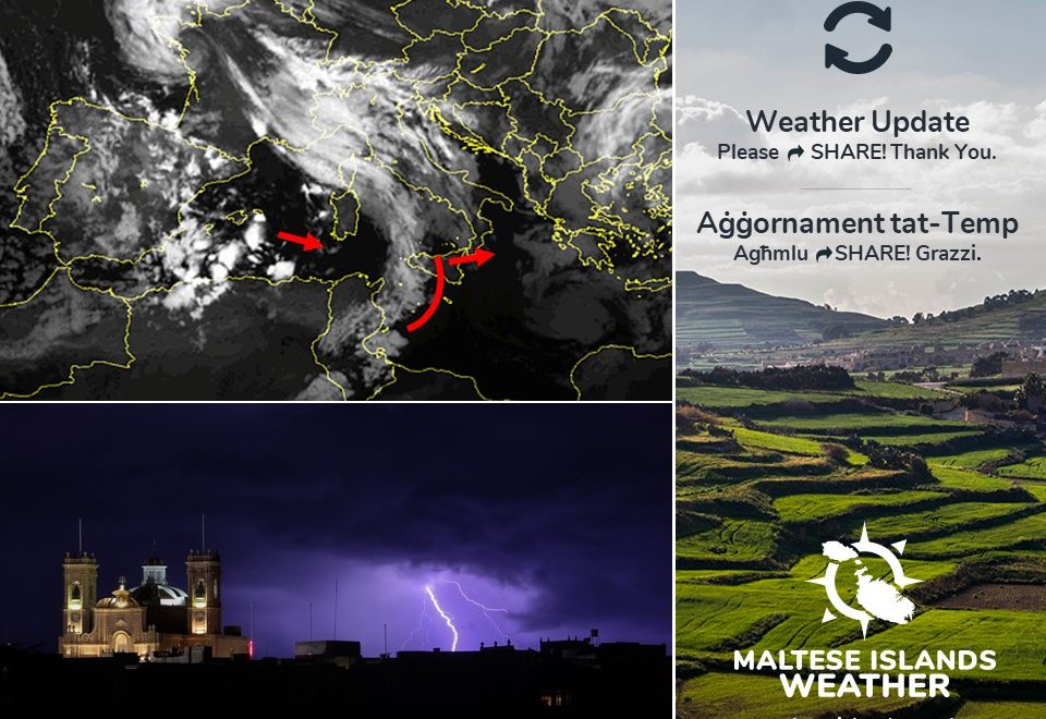
The peak gusts will blow across the Maltese Islands in the late afternoon and early evening of Sunday 21/04.

The sea will be very rough, with wave heights of up to 6.1 metres in peak gusts. The swell will be a low at times moderate Southeast. The map shows the area of coastline most exposed to this strong wind.


It-terminu ‘Sirocco’ jirreferi għal riħ sħun u umdu mix-Xlokk għal-Lbiċ li jorriġinaw bħala arja sħuna u niexfa minn fuq id-deżert tas-Sahara lejn in-nofsinhar tal-Mediterran. Is-Sirocco huwa kkawżat meta sistema ta’ pressjoni baxxa tkun miexja lejn il-lvant minn fuq l-Afrika ta’ fuq jew in-nofsinhar tal-Mediterran.

Din it-twissija ta’ riħ qawwi se tkun valida minn nofsilejl tal-Ħadd 21/04 sa 18:00 tat-Tnejn 22/04. Din se tkun aġġornament kif u jekk ikun hemm bżonn. Id-dettalji ta’ hawn taħt juru kif se tiżviluppa s-sitwazzjoni matul il-ħin stipulat.

Il-Ħadd 21/04

00:00 sa 03:00 – Xlokk il-Lvant Forza 5/6
03:00 sa 06:00 – Xlokk il-Lvant Forza 6/7
06:00 sa 09:00 – Xlokk il-Lvant Forza 7/8
09:00 sa 12:00 – Xlokk il-Lvant Forza 7/8
12:00 sa 15:00 – Xlokk il-Lvant Forza 7/8
15:00 sa 18:00 – Xlokk il-Lvant Forza 8/9
18:00 sa 21:00 – Xlokk il-Lvant Forza 8/9
21:00 sa 00:00 – Xlokk il-Lvant Forza 8/9

It-Tnejn 22/04

00:00 sa 03:00 – Xlokk il-Lvant Forza 7/8
03:00 sa 06:00 – Xlokk il-Lvant Forza 6/7
06:00 sa 09:00 – Xlokk il-Lvant Forza 6/7                                                                                                                                09:00 sa 12:00 – Xlokk il-Lvant Forza 7/8
12:00 sa 15:00 – Xlokk il-Lvant Forza 6/7                                                                                                                            15:00 sa 18:00 – Xlokk il-Lvant Forza 5/6

Il-buffuri l-aktar qawwijin se jaffetwaw lil Gżejjer Maltin tard wara nofsinhar u kmieni filgħaxija tal-Ħadd 21/04.

Il-baħar se jkun qawwi ħafna, b’mewġ ta’ 6.1 metri fl-aktar buffuri qawwija. L-imbatt ikun ħafif kultant moderat mix-Xlokk. Il-mappa ta’ hawn taħt turi l-kosta l-aktar milquta minn dan ir-riħ.

Updates

Sahara Desert weather / Temp tad-Deżert tas-Sahara

As forecast since last week, Easter weekend is set to be marred by a low pressure system traversing across northern Africa. A strong Sirocco will affect the central Mediterranean as a result of this. A very strong Sirocco wind occurs in advance of low pressure systems moving eastward across the southern Mediterranean Sea or northern Africa. The wind has already starting gaining speed, and will continue to do so over the course of Friday 19/04 (Good Friday) and Saturday 20/04 (Easter Saturday), before reaching its peak on Sunday 21/04 (Easter Sunday). It is set to reach Force 8/9 at its peak, in the afternoon on Sunday 21/04 (Easter Sunday). Abundant fine desert sand is also going to choke our atmosphere. This is already present in the atmosphere above us, but it will increase in its  amount as the weekend progresses, peaking in the afternoon on Sunday 21/04 (Easter Sunday). The sky will glow red (especially at night) as a result of this. Some light rain will deposit much of this fine desert sand on Monday 22/04. The sky will be covered by an extensive grey cloud for up to three days as well. Outdoor events over these few days may be affected by the inclement weather. Fine weather will return to the Maltese Islands on Tuesday 23/04, when winter weather should come to a definite end, and long-lasting spring weather finally takes hold of our islands. More about that at a later date.

Kif imbassar mill-ġimgħa l-oħra, il-festi ta’ l-Għid se jkunu mtappnin minn sistema ta’ pressjoni baxxa li se tkun għaddejha minn fuq l-Afrika ta’ fuq. Riħ qawwi mix-Xlokk il-Lvant se jaffetwana minħabba dan. Riħ qawwi mix-Xlokk il-Lvant huwa kkawżat meta sistema ta’ pressjoni baxxa tkun miexja lejn il-lvant minn fuq l-Afrika ta’ fuq jew in-nofsinhar tal-Mediterran. Ir-riħ diġa beda jżid fil-qawwa tiegħu, u se jkompli jżid matul il-jum tal-Ġimgħa 19/04 (Il-Ġimgħa l-Kbira) u s-Sibt 20/04 (Sibt il-Għid), sa ma jilħaq l-aqwa tiegħu l-Ħadd 21/04 (L-Għid il-Kbir). Għandu jonfoħ bil-qawwa ta’ Forza 8/9 fl-aqwa tiegħu, nhar il-Ħadd 21/04 (L-Għid il-Kbir). Ramel fin fl-arja se jkun abbundanti fl-atmosfera. Dan diġa huwa preżenti, u se jżid b’kull ma jmur, qabel ma jilħaq l-aqwa tiegħu wara nofsinhar tal-Ħadd 21/04 (L-Għid il-Kbir). Is-sema se jkun aħmar (speċjalment billejl) minħabba dan. Xi ftit xita ħafifa jew irxiex tal-ħamrija għandha tkun mistennija nhar it-Tnejn 22/04. Is-sema se jkun mgħotti bi sħab griż għal dawn it-tlett ijiem. Avvenimenti ta’ barra jaf ikunu affetwati minn dan il-maltemp. Temp sabiħ għandu jirritorna nhar it-Tlieta 23/04, meta t-temp xitwi għandu jasal fi tmiem ċert u temp tar-rebbiegħa jasal fil-gżejjer tagħna. Aktar informazzjoni dwar dan aktar tard.

Updates

Poor weather for Easter / Temp ikrah għal Għid

Very poor weather is being anticipated for the Maltese Islands this weekend. Easter weekend will be marred by a low pressure system traversing across northern Africa. A very strong Sirocco is being anticipated across the central Mediterranean. The term Sirocco is an all-inclusive name given to hot and subsequently humid southeast to southwest winds originating as hot, dry desert-air over Northern Africa, flowing northward into the southern Mediterranean basin. A very strong Sirocco wind occurs in advance of surface and upper level depressions moving eastward across the southern Mediterranean Sea or northern Africa. The Sirocco wind will start picking up on Thursday 18/04 (Maundy Thursday), increasing gradually on Friday 19/04 (Good Friday)  and Saturday 20/04 (Easter Saturday) before reaching its peak on Sunday 21/04 (Easter Sunday) and Monday 22/04. It is expected to reach Force 8/9 at its peak. The wind will blow a blanket of fine desert sand over the central Mediterranean. This will reduce visibility locally. The sky will be covered by an extensive grey cloud for up to four days. No rain is being anticipated. Outdoor events over these couple of days may be affected by the inclement weather. Stay tuned to our page for the latest details.

Temp ikrah ħafna huwa mistenni fil-Gżejjer Maltin fi tmiem il-ġimgħa. Il-festi tal-Ġimgħa Mqaddsa mistennija jkunu imtappna b’sistema ta’ pressjoni baxxa li se tkun għaddejha minn fuq l-Afrika ta’ fuq. Riħ qawwi ħafna mix-Xlokk (Sirocco) għandu jaħkem iċ-ċentru tal-Mediterran. It-terminu ‘Sirocco’ jirreferi għal riħ sħun u umdu mix-Xlokk għal-Lbiċ li jorriġinaw bħala arja sħuna u niexfa minn fuq id-deżert tas-Sahara lejn in-nofsinhar tal-Mediterran. Is-Sirocco huwa kkawżat meta sistema ta’ pressjoni baxxa tkun miexja lejn il-lvant minn fuq l-Afrika ta’ fuq jew in-nofsinhar tal-Mediterran. Ir-riħ mix-Xlokk se jibda jżid fil-qawwa nhar il-Ħamis 18/04 (Ħamis ix-Xirka), u jżid bilmod matul il-jiem tal-Ġimgħa 19/04 (Il-Ġimgħa l-Kbira) u s-Sibt 20/04 (Sibt il-Għid) qabel ma jilħaq l-aqwa tiegħu l-Ħadd 21/04 (L-Għid il-Kbir) u t-Tnejn 22/04. Mistennija jonfoħ b’Forza 8/9 fl-aqwa tiegħu. Ir-riħ se jġib miegħu ramel fin fl-arja minn fuq id-deżert. Din se twassal għal nuqqas fil-viżibilita. Is-sema se jkun mgħotti bi sħab griż estensiv għal madwar erbat ijiem. Mhux qed nistennew xita. Avvenimenti pjanati għal barra matul dawn il-jiem jistgħu jkunu affetwati bil-maltemp. Żuru l-paġna tagħna frekwentament għal aħħar aħhbarijiet.

Updates

This week: Poor weather for Easter

This week is off to a sunny start, as the Maltese Islands enjoy a spell of true spring weather. This fine weather is the result of a ridge of high pressure over the central Mediterranean. Once again, this will be short-lived though. An intense low pressure system will traverse eastwards across north Africa during Easter weekend. It will affect the Maltese Islands from late on Thursday 18/04 onward. Weather conditions over Easter weekend will be very poor. A very strong wind from the East will blow for a number of days. It peaks on Easter Sunday, when it could blow at Force 8/9. Additionally, the sky will be overcast and the air hazy due to airborne fine desert sand for at least four days polska-ed.com. No rain is being anticipated, however. Stay tuned to our page for the latest weather updates.

Taking a look at the weather across the Maltese Islands over the coming week, the average maximum temperature will be around 18°C, with a high for the week peaking at 19°C on Wednesday 17/04 and Thursday 18/04. The average minimum temperature will be 13°C, dipping to its lowest of 11°C on Tuesday 16/04. Winds are expected to be moderate at first till Wednesday 17/04, before strengthening greatly on Thursday 18/04. It will be at its strongest on Easter Sunday.

Updates

Is spring finally here? / Sa fl-aħħar waslet ir-rebbiegħa?

Latest weather maps are indicating that spring could finally be here to stay. Apart from the occasional isolated shower and strong winds, the weather across the Maltese Islands is expected to be mainly fine for much of the time. Temperatures will rise, and the sun will shine uninterrupted on most days. This is the result of successive ridges of high pressure rising from north Africa to cover the central and western Mediterranean. This high pressure will act as a barrier, preventing low pressure systems over the Atlantic from penetrating our region. This high pressure will also allow warm air from over north Africa to reach us. Simultaneously, an anticyclone over northern Europe will weaken greatly. This will encourage the storm track to return to its normal position in the coming days. Preliminary forecasts have revealed that the weather over Easter weekend will be mainly fine too.

L-aħħar mapep tat-temp qed jindikaw li r-rebbiegħa jista jkun li issa waslet u se żżomm. Minbarra xi ħalba xita iżolata u riħ qawwi f’xi ġranet, it-temp madwar il-Gżejjer Maltin mistenni li jkun il-biċċa l-kbira sabiħ għal biċċa l-kbira tal-ħin. It-temperaturi se jogħlew, u x-xemx se tiddi għal siegħat sħaħ f’ħafna ġranet. Dan huwa r-riżultat ta’ firxa ta’ pressjoni baxxa, waħda wara l-oħra, minn fuq l-Afrika li se tgħatti ċ-ċentru u l-punent tal-Mediterran. Din il-pressjoni għolja se żżomm sistemi ta’ pressjoni baxxa minn fuq l-Atlantiku minn li jilħquna. Din il-pressjoni għolja se tinkoraġġixxi arja sħuna minn fuq l-Afrika biex titla l-fuq u tilħaqna. Fl-istess waqt, l-antiċiklun fuq it-trmuntana ta’ l-Ewropa se jidgħajjef. Dan se jwassal biex il-maltemp jersaq aktar lejn it-tramuntana. L-ewwel indikazzjonijiet juru li t-temp fil-Ġimgħa Mqaddsa se jkun il-biċċa l-kbira sabiħ ukoll.

Updates

Possibility of thunderstorms / Possibilita ta’ maltempati bir-ragħad

After five long days of grey sky, the Maltese Islands enjoyed some beautiful sunshine on Saturday 06/04. That will be short-lived though. Two successive cold fronts will be moving across the central Mediterranean over a period of 18 hours. The first of these will reach us at around noon on Sunday 07/04. The second one will move by just after midnight on Monday 08/04. Both cold fronts should bring with them a thunderstorm each to our shores. Any thunderstorms will be heavy and also possibly blustery and with hail at times. We will inform you well in advance of the arrival of any thunderstorms. Apart from these two thunderstorms, we should get some isolated showers. Isolated showers may occur at any time from early morning on Sunday 07/04 till early morning on Monday 08/04. Gozo is expected to be the most affected. Up to 20 mm of precipitation may be measured in the hardest hit localities. No severe weather is being anticipated. These cold fronts will bring colder temperatures and stronger winds to the Maltese Islands as well. The maximum temperature on both days will struggle to reach 15 C. The minimum temperature at night may dip to below 10 C. A strong Northwest to West wind is expected on Monday 08/04. It will reach Force 6/7 at times.

Wara ħamest ijiem ta’ sema griż u temp ċlampu, il-Gżejjer Maltin gawdew minn xemx tiżreġ matul il-jum tas-Sibt 06/04. Din il-waqfa ta’ temp bnazzi mhux se ddum pero. Żewġ fronti ta’ arja kiesħa se jgħaddu minn fuq iċ-ċentru tal-Mediterran fuq perjodu ta’ 18-il siegħa. L-ewwel minn dawn se jilħaqna għal ħabta ta’ nofsinhar tal-Ħadd 07/04. L-ieħor mistenni li jmissna lejn nofsillejl tat-Tnejn 08/04. Dawn iż-żewġ fronti għandhom iġibu magħhom maltempata bir-ragħad kull wieħed lejn xtutna. Dawn ikunu qawwijin u possibilment anke mirjieħa u bis-silġ kultant. Aħna ninfurmawkhom minn ħafna qabel il-wasla ta’ maltempati bir-ragħad. Minbarra sawn il-maltempati bir-ragħad, għandna naraw xi ħalbiet iżolati tax-xita. Dawn jistgħu jmissuna minn kmieni filgħodu tal-Ħadd 07/04 sa kmieni filgħodu tat-Tnejn 08/04. Għawdex għandu jintlaqat l-aktar. Xi 20 mm ta’ xita tista titkejjel fl-aktar postijiet milquta minn dawn. Mhux qed nistennew maltemp sever. Dawn iż-żewġ fronti kesħin se jġibu magħhom temperaturi aktar baxxi u riħ qawwi lejn il-Gżejjer Maltin. It-temperatura massima se tbati biex tilħaq 15 C. L-anqas billejl taf tinżel taħt 10 C. Riħ qawwi mill-Majjistral għal-Punent huwa mistenni nhar it-Tnejn 08/04. Dan se jilħaq Forza 6/7 kultant.

Updates

When will we see the sun again? Meta se nerġgħu naraw ix-xemx?

With 2,957 hours of sunshine a year, Malta is Europe’s sunniest country. It’s been the contrary lately, though. The sky’s been covered in a featureless grey cloud for the past couple of days. In fact, it’s been one of the dullest ever starts to April. Many are asking us: When will we see the sun again?! The rest of Thursday 04/04 will remain cloudy with some light rain from time to time. Friday 05/04 is expected to be another dull day. There will also be some isolated showers, as a thunderstorm is expected to miss the Maltese Islands by a whisker. The sun is expected to make an appearance on Saturday 06/04. The sky on that day will be characterised by patches of cloud floating around, with dappled sunshine in between. That won’t be the last of the clouds though. Sunday 07/04 should be another cloudy day with the possibility of a thunderstorm. High pressure will return to the central Mediterranean Monday 08/04. This will restore sunny skies and warmer temperatures across the Maltese Islands. Having said that, further bad weather may be expected next week, as the shaky start to spring continues.

B’2,957 siegħa ta’ xemx fis-sena, Malta hija l-aktar pajjiż imdawwal fl-Ewropa. Dan l-aħħar ma kienx hekk, pero. Is-sema kien miksi bi sħab griż u temp ċlampu f’dawn l-aħħar jiem. Filfatt, dan kien wieħed mill-aktar bidu msaħħab ta’ April li qatt kellna. Ħafna qiegħdin jistaqsuna: Meta se nerġgħu naraw ix-xemx?! Il-bqija tal-Ħamis 04/04 se jibqa msaħħab b’xita ħafifa minn ħin għal-ieħor. Il-Ġimgħa 05/04 għandu jkun jum ieħor ta’ sħab. Se jkun hemm ukoll xi ħalbiet tax-xita, hekk kif maltempata bir-ragħad mistennija taqbiżna bi ftit. Ix-xemx titfaċċa nhar is-Sibt 06/04. Dik għandha tkun ġurnata ta’ daqsxejn sħab b’waqtiet xemxin. Dak mhux se jkun l-aħħar tas-sħab, pero. Il-Ħadd 07/04 mistennija tkun ġurnata oħra ta’ sħab u bil-possibilita ta’ maltempata bir-ragħad. Pressjoni għolja se tkun qed tirritorna lura lejn iċ-ċentru tal-Mediterran nhar it-Tnejn 08/04. Din mistennija ġġib magħha xemx tiżreġ u temperaturi ferm aktar sħan. Minkejja dan, aktar maltemp għandu jaħkimna il-ġimgħa li ġejja, hekk kif il-bidu inċert lir-rebbiegħa jkompli.

Updates

This week: An unstable start to April

After a weekend of uninterrupted bright sunshine, April is off to an unstable start, as a series of low pressure systems from over north Africa and the Atlantic will be reaching the central Mediterranean throughout this week. The sky will be covered in grey clouds on most days this week. Some isolated showers will affect several places over the coming days, with some rain being expected almost on all days of this week. Having said that, much of the rain will fall on three days: morning on Tuesday 02/04, morning on Thursday 04/04 and in the evening on Friday 05/04. The heaviest rain is expected on the latter, when it may be accompanied by thunder. The lighter rain will deposit fine desert sand. We might get a break from the grey skies on Wednesday 03/04, however. High pressure should once again bring fine weather to the Maltese Islands at the weekend. Temperatures will be fairly uniform over this week with the new month bringing us some warmer weather.

Taking a look at the weather across the Maltese Islands over the coming week, the average maximum temperature will be around 17°C, with a high for the week peaking at 18°C on several days. The average minimum temperature will be of 12°C, dipping to its lowest of 9°C on Monday 01/04 and Wednesday 03/04. This week is likely to see some precipitation. Much of the rain will fall on three days: morning on Tuesday 02/04, morning on Thursday 04/04 and in the evening on Friday 05/04. Around 15 mm of rainfall are expected in the wettest parts of the Maltese Islands. Winds are expected to be light to moderate on most days, strengthening only on Thursday 04/04, when the Southeast wind reaches Force 6/7 at times.