Updates

For the latest updates related to the weather in the Maltese Islands. So keep yourself updated by visiting this page frequently or like our Facebook page.

Updates

3 Hourly Forecast for Freedom Day (31/03/2019)

00:00 to 03:00 – clear; 12 C to 11 C; Variable Force 1/2
03:00 to 06:00 – clear; 11 C to 10 C; Variable Force 1/2
06:00 to 09:00 – clear; 10 C to 14 C; Variable Force 1/2
09:00 to 12:00 – clear; 14 C to 17 C; Variable Force 1/2
12:00 to 15:00 – clear; 17 C to 16 C; Variable Force 1/2
15:00 to 18:00 – clear; 16 C to 15 C; Variable Force 1/2
18:00 to 21:00 – clear; 15 C to 13 C; Variable Force 1/2
21:00 to 00:00 – clear; 13 C to 12 C; Variable Force 1/2

Freedom Day, or Jum il-Ħelsien in Maltese, is a Maltese national holiday celebrated annually on 31 March. This is the anniversary of the withdrawal of British troops and the Royal Navy from Malta in 1979. The Government had been wanting to re-negotiate the lease agreement with the United Kingdom throughout the 1970s. Following protracted and sometimes tense talks, a new agreement was signed whereby the lease was extended till the end of March 1979 at a vastly increased rent. On 31 March 1979 the last British Forces left Malta. For the first time in a millennium, Malta was no longer a military base of a foreign power and it became independent de facto as well as de jure. The main events of the activities commemorating this date take place at the Freedom Day Monument at Birgu and at the War Memorial in Floriana. In the afternoon the Grand Harbour hosts a competitive regatta.

Updates

Move clocks forward one hour / Inmexxu l-arloġġi ‘l quddiem b’siegħa

We set clocks forward an hour tonight. The German Empire and its World War I ally Austria-Hungary were the first to use Daylight Saving Time (DST) as a means of conserving coal during wartime. Others followed suit. Numerous countries abandoned it in the years following World War II. Since then, the world has seen several enactments, adjustments, and repeals. Much of Africa, Asia, South America and Oceania do not follow it anymore. There are several arguments about this, both in favour and against. MEPs have voted to end summer and winter time switch in 2021. Each EU country will now have to decide which time it wants to stick to, with clocks changing for the last time in March or October 2021, depending on what member states’ choose. If we stick to summer time, it will be darker in the mornings in winter, but there will be much more light in the evening. If we stick to winter time, there will be more light in the mornings in winter, but it will get dark earlier in the summer. Daylight Saving Time (DST) begins tonight, so do not forget to move your clock forward one hour before going to bed tonight. Tomorrow, the sun rises at 06:50 and sets at 19:22, as summer slowly sets in.

Illejla nmexxu il-ħin siegħa il-quddiem. L-Imperu Ġermaniż u l-alleati tagħhom l-Awstrija-Ungerija kienu l-ewwel li użaw id-Daylight Saving Time (DST) fl-Ewwel Gwerra Dinjija. Dan għamluh biex jikkonservaw il-faħam fi żmien il-gwerra. Oħrajn imxew fl-eżempju tagħhom. Numru ta’ pajjiżi abbandunaw din is-sistema fis-snin ta’ wara i-Tieni Gwerra Dinjija. Minn dakinhar l-hawn, diversi pajjiżi raw promulgazzjoni, aġġustamenti u tibdil. Il-biċċa l-kbira ta’ l-Afrika, l-Asja, l-Amerika ta’ Isfel u l-Awstralja ma għadhomx juzawha din is-sistema. Hemm diversi argument, kemm favur kif ukoll kontra d-Daylight Saving Time (DST). MPEs ivvutaw biex itemmu din is-sistema fl-Ewropa fl-2021. Il-pajjiżi kollha ta’ l-Unjoni Ewropeja issa jridu jiddeċiedu jekk hux se jżommu l-ħin tas-sajf jew dak tax-xitwa. Il-ħin se jinbidel l-aħħar f’Marzu jew Ottubru ta’ l-2021, skont l-għażla tal-istati. Jekk niddeċiedu li nżommu l-ħin tas-sajf, se jkollna aktar dlam filgħodu fix-xitwa, imma aktar dawl filgħaxija. Jekk inżommu l-ħin tax-xitwa, se jkun hemm aktar dawl filgħodu fix-xitwa, imma se jidlam aktar kmieni fis-sajf. Daylight Saving Time (DST) jibda llejla. Għalhekk, tinsewx tmexxu l-arloġġi siegħa ‘l quddiem qabel tidħlu torqdu. Għada x-xemx titla fis-06:50 u tinżel fis-19:22, hekk kif qed joqrob is-sajf.


Updates

Brief spell of bad weather on Wednesday 27/03 / Waqfa qasira ta’ maltemp l-Erbgħa 27/03

As forecast, bad weather will be returning to the Maltese Islands for one day on Wednesday 27/03. This will be the result of a cold front associated with a low pressure system over the Tyrrhenian Sea. The cold front will be moving across the central Mediterranean early in the day on Wednesday 27/03. It will manifest itself as increasing cloudiness later in the day on Tuesday 26/03. There will also be a significant drop in air temperature. Whilst the maximum on Tuesday 26/03 soared to 19 C, the high on Wednesday 27/03 will struggle to reach 14 C. The nighttime minimum may drop to below 10 C. Another impact of this cold front will be a series of showers which could be briefly heavy and thundery at times. Isolated showers are possible at any time on Wednesday 27/03, but much of the rain is to be expected between 04:00 and 13:00. A total of up to 15 mm may be measured in the hardest hit localities. The southwest of Malta should be the wettest. The wind will be light and variable on the day. The rain will be clean.

Kif imbassar, il-maltemp se jirritorna lejn il-Gżejjer Maltin għal ġurnata waħda biss nhar il-Erbgħa 27/03. Dan se jkun ir-riżultat ta’ front ta’ arja kiesħa assoċjat ma’ sistema ta’ pressjoni baxxa fuq il-Baħar Tirren. Il-front ta’ arja kiesħa se jgħaddi minn fuq iċ-ċentru tal-Mediterran kmieni fil-jum ta’ l-Erbgħa 27/03. L-ewwel sinjal ta’ dan se jkun sema li jsir dejjem aktar imsaħħab matul il-jum tat-Tlieta 26/03. Se jkun hemm ukoll waqa fit-temperaturi. L-ogħla tat-Tlieta 26/03 messet 19 C. L-ogħla ta’ l-Erbgħa 27/03 għandha x-xorti tmiss 14 C. L-anqas matul il-lejl tista tinżel taħt 10 C. Impatt ieħor ta’ dan il-front ta’ arja kiesħa se jkunu serje ta’ ħalbiet tax-xita li jistgħu jkunu qawwijin u bir-ragħad għal ftit ħin kultant. Iċ-ċans ta’ ħalbiet iżolati tax-xita se jkopri l-jum kollu ta’ l-Erbgħa 27/03, minkejja li x-xita mistennija l-aktar bejn 04:00 u 13:00. Total ta’ 15 mm għandu jitkejjel fl-aktar lokalitajiet milquta. In-naħa ta’ l-lbiċ ta’ Malta għandha tara l-aktar xita. Ir-riħ se jkun ħafif u varjabbli. Ix-xita se tkun nadifa.

Updates

This week: A mixture of weather

As promised, the Maltese Islands enjoyed a uninterrupted bright sunshine on Sunday 24/03. This was the result of a ridge of high pressure over the central Mediterranean. The fine weather will linger on into Monday 25/03 and Tuesday 26/03, as the ridge of high pressure remains stationary over our region. A low pressure system will develop over the Gulf of Genoa at the start of this week. It should then move south towards the central Mediterranean. It will reach our region late on Tuesday 26/03, pushing the ridge of high pressure away. This will be marked by a gradually increasing cloud cover very late in the day. Wednesday 27/03 is expected to be characterised by isolated showers. Thursday 28/04 will be rather cloudy with residual isolated showers. High pressure should return on Friday 29/04, heralding the start of a longer spell of bright sunshine. Temperatures will be much cooler over the coming week, since air from over the Balkans will be blown over the central Mediterranean.

Taking a look at the weather across the Maltese Islands over the coming week, the average maximum temperature will be around 17°C, with a high for the week peaking at 19°C expected on Monday 25/03 and Tuesday 26/03. The average minimum temperature will be of 11°C, dipping to its lowest of 10°C on several mornings. This week is likely to see some precipitation, especially at midweek. Winds are expected to be moderate to strong on most days, with the strongest expected early on Friday 29/03, when the Northeast wind reaches Force 5/6 at times.

Updates

Sunshine for two days. Rain returns on Tuesday / Xemx għal jumejn. Ix-xita tirritorna t-Tlieta

Bright sunshine has returned to the Maltese Islands. It’s the result of a ridge of high pressure across the central Mediterranean. This spell of splendid weather will be very short-lived, however, as low pressure will mark a swift return of rain to our shores. The weather on both Sunday 24/03 and Monday 25/03 will be sunny and warm. The wind will be mainly light. Tuesday 26/03 will start off with fine weather too, but should become increasingly cloudy as the day wears on, with rain to be experienced from late in the evening onward. This spell of bad weather should then linger on till the weekend, when a longer, and more spring-like spell of fine weather begins towards the end of March.


Xemx tiżreġ reġgħet lura fuq il-Gżejjer Maltin. Dan huwa r-riżultat ta’ firxa ta’ pressjoni għolja fuq il-ċentru tal-Mediterran. Dan il-waqfa ta’ temp sabiħ ferm se tkun qasira ħafna, pero’, hekk kif pressjoni baxxa se ġġib ix-xita lura lejn xtutna kmieni l-ġimgħa d-dieħla. It-temp nhar il-Ħadd 24/03 u t-Tnejn 25/03 se jkun xemxi u sħun. Ir-riħ se jkun pjuttost ħafif. Il-jum tat-Tlieta 26/03 ukoll se jibda sabiħ ġafna, imma għandu jsir dejjem aktar imsaħħab hekk kif tipprogressa l-ġurnata, bix-xita mistennija terġa tilħaqna minn tard filgħaxija l-quddiem. Din il-waqfa ta’ maltemp għandha tkompli sa tmiem il-ġimgħa li ġejja, meta temp aktar sinonimu mar-rebbiegħa u fit-tul għandu jibda lejn l-aħħar ta’ Marzu.

Updates

Further Showers and Thunderstorms on Friday 22/03 / Aktar Xita u Maltempati l-Ġimgħa 22/03

Exactly as forecast, the Maltese Islands were affected by a thunderstorm which was heavy and with hail in the afternoon on Thursday 21/03. Also as forecast, Gozo and the west of Malta were most affected. Further showers and thunderstorms are set to affect us on Friday 22/03. A warm front associated with a low pressure system over the Gulf of Gabes will pass over the central Mediterranean on Friday 22/03. A band of rain will be associated with this warm front. A number of isolated thunderstorms might be embedded within. Steady periods of rain, which may be heavy at times, are to be expected. In the event of an isolated thunderstorm moving across parts of the Maltese Islands, hail and waterspouts will be possible. Rain is possible throughout the day on Friday 22/03. Totals may exceed 25 mm in hardest hit areas. Gozo and northeast Malta should be the wettest. The passing of the warm front will generate a strong wind from the East, as described in a separate warning.


Eżatt kif kien imbassar, il-Gżejjer Maltin intlaqtu minn maltempata bir-ragħad li kienet qawwija u bis-silġ wara nofsinhar tal-Ħamis 21/03. Eżattament kif kien imbassar, Għawdex u l-punent ta’ Malta kien l-aktar milquta. Aktar ħalbiet tax-xita u maltempati bir-ragħad għandhom jaffetwawna l-Ġimgħa 22/03. Front ta’ arja sħuna assoċjat ma’ sistema ta’ pressjoni baxxa fuq il-Golf ta’ Gabes se tgħaddi minn fuq iċ-ċentru tal-Mediterran il-Ġimgħa 22/03. Massa ta’ sħab tax-xita se tkun assoċjata ma’ dan il-front ta’ arja sħuna. Numru ta’ maltempati iżolati bir-ragħad jistgħu jifformaw qalb il-massa ta’ sħab tax-xita. Perjodi ta’ xita kontinwa, li jistgħu jkunu qawwija kultant, għandhom jolqtuna. Jekk tolqotna maltempata bir-ragħad iżolata, stennew silġ jew trombi. Iċ-ċans ta’ xita se jkun għoli matul il-jum kollu tal-Ġimgħa 22/03. It-total ta’ xita jaf jaqbeż 25 mm fl-aktar inħawi milquta. Għawdex u l-grigal ta’ Malta se jkunu l-aktar imxarrba. Il-front ta’ arja sħuna se jiġġenera riħ qawwi mill-Lvant, kif deskritt fi twissija maħruġa separatament.

Updates

STRONG WIND WARNING / TWISSIJA TA’ RIĦ QAWWI

A low-pressure system remains stationary over the Gulf of Gabes. An anticyclone maintains its position over central Europe and the Balkans. This will cause a strong, cool easterly wind to affect the Maltese Islands once again. The wind will not be as strong this time round. This strong wind warning is valid from 06:00 on Friday 22/03 till 06:00 on Saturday 23/03. This will be updated if and when necessary. The details below describe how the situation will develop over this time period.


Friday 22/03

06:00 to 09:00 – East Force 6/7

09:00 to 12:00 – East Force 7/8

12:00 to 15:00 – East Force 6/7

15:00 to 18:00 – East Force 6/7

18:00 to 21:00 – East Force 7/8

21:00 to 00:00 – East Force 6/7


Saturday 23/03

00:00 to 03:00 – East Force 6/7

03:00 to 06:00 – East Force 6/7


The peak gusts will blow across the Maltese Islands in the evening on Friday 22/03. The wind will turn Northeast and decrease rapidly to Force 3/4 by morning on Saturday 23/03.

The sea will be very rough, with wave heights of up to 4.0 metres in peak gusts. The swell will be a low East. The map shows the length of coastline most exposed to this strong wind.


Sistema ta’ pressjoni baxxa se tibqa stazzjonarja fuq il-Golf ta’ Gabes. Antiċiklun se jkun qed jżomm postu fuq iċ-ċentru ta’ l-Ewropa u l-Balkani. Dan se jwassal għal-riħ qawwi u frisk mill-Lvant madwar il-Gżejjer Maltin. Ir-riħ mhux se jkun daqshekk qawwi daqs ta’ l-aħħar siegħat. Din it-twissija ta’ riħ qawwi se tkun fis-seħħ minn 06:00 tal-Ġimgħa 22/03 sa 06:00 tas-Sibt 23/03. Dawn id-dettalji jkunu aġġornament jekk ikun hemm bżonn. Id-dettalji ta’ hawn taħt juru kif se tiżviluppa s-sitwazzjoni matul il-ħin li ġej.


Il-Ġimgħa 22/03

06:00 sa 09:00 – Lvant Forza 6/7

09:00 sa 12:00 – Lvant Forza 7/8

12:00 sa 15:00 – Lvant Forza 6/7

15:00 sa 18:00 – Lvant Forza 6/7

18:00 sa 21:00 – Lvant Forza 7/8

21:00 sa 00:00 – Lvant Forza 6/7


Is-Sibt 23/03

00:00 sa 03:00 – Lvant Forza 6/7

03:00 sa 06:00 – Lvant Forza 6/7


Il-buffuri l-aktar qawwija mistennija filgħaxija tal-Ġimgħa 22/03. Ir-riħ se jdur Grigal u jonqos malajr għal-Forza 3/4 sa kmieni s-Sibt 23/03 filgħodu.

Il-baħar se jkun qawwi ħafna, b’mewġ għoli 4.0 metri fl-aktar buffuri qawwija. L-imbatt se jkun baxxa mill-Lvant polska-ed.com. Il-mappa tindika l-kosta l-aktar esposta għal dan ir-riħ.

Updates

Showers and a Thunderstorm on Thursday 21/03 / Xita u Maltempata bir-Ragħad il-Ħamis 21/03

Exactly as forecast, the Maltese Islands are being affected by a very strong wind from the East Northeast. As was forecast, parts of the Maltese Islands experienced some light rain on Wednesday 20/03. That was the first of three episodes of rainfall expected over the central Mediterranean this week. The next episode of rainfall will affect us on Thursday 21/03. A front over the Gulf of Gabes should extend towards the Maltese Islands overnight, and reach us in the morning. This will bring some showers to the Maltese Islands from mid-morning till late afternoon. Any showers may be heavy at times. A thunderstorm which may be heavy and with hail could reach us in the early afternoon. Total rainfall should exceed 10 mm in hardest hit localities. Gozo and the west of Malta should be the wettest. No severe thunderstorms are being anticipated. Furthermore, just as explained in the warning issued on Tuesday 19/03, the East Northeast wind is set to remain very strong till early afternoon on Thursday 21/03, before picking up again on Friday 22/03. Further showers and thunderstorms will also affect us on Friday 22/03 and Saturday 23/03. These will be discussed in a separate update.

Eżatt kif kien imbassar, il-Gżejjer Maltin qed jesperjenzaw riħ qawwi ħafna mill-Grieg il-Lvant. Kif kien imbassar, xi nħawi tal-Gżejjer Maltin raw xi ftit xita ħafifa fil-jum ta’ l-Erbgħa 20/03. Din kienet l-ewwel minn tliet episodju ta’ xita li mistennija jaħkmu iċ-ċentru tal-Mediterran matul din il-ġimgħa. L-episodju ta’ xita li jmiss mistenni jaffetwana il-Ħamis 21/03. Front fuq il-Golf ta’ Gabes se jkun qed jestendi lejn il-Gżejjer Maltin matul il-lejl, u jilħaqna filgħodu. Dan se jġib miegħu numru ta’ ħalbiet tax-xita fuq il-Gżejjer Maltin minn tard filgħodu sa tard wara nofsinhar. Il-ħalbiet tax-xita jistgħu jkunu qawwijin kultant. Maltempata bir-ragħad li tista tkun qawwija u bis-silġ tista tilħaqna kmieni wara nofsinhar. It-total ta’ xita se jaqbeż l-10 mm fl-aktar lokalitajiet milquta. Għawdex u l-punent ta’ Malta għandhom ikunu l-aktar imxarrba. L-ebda maltempati bir-ragħad severi ma għandhom jaffetwawna. Barra minn hekk, kif spjegat fit-twissija li ħriġna t-Tlieta 19/03, ir-riħ qawwi mill-Grieg il-Lvant mistenni jiqa qawwi ħafna sa kmieni wara nofsinhar tal-Ħamis 21/03, qabel ma jerġa jżid il-Ġimgħa 22/03. Aktar ħalbiet tax-xita u maltempati bir-ragħad se jaffetwawna il-Ġimgħa 22/03 u s-Sibt 23/03. Dawn se jiġu diskussi f’aġġornament separat.

Updates

Bad weather returns / Jirritorna l-maltemp

An upper level trough associated with an intense low pressure system over the Gulf of Gabes will bring bad weather to our shores over the next few days. This will affect us in two major ways. Firstly, a very strong wind from the East Northeast to East will blow across exposed areas of the Maltese Islands on Wednesday 20/03 and Thursday 21/03. The wind will reach Force 7/8 at times, as described in a warning issued separately. Secondly, this upper level trough will bring us a series of showers and thunderstorms. These should come in three distinct episodes. The first, and the lightest, is expected before dawn on Wednesday 20/03. Only a few isolated showers are expected then. The second will reach us from late morning till early evening on Thursday 21/03. These may be heavy, thundery and with hail at times. The third, and most intense, will take place from late morning till late evening on Friday 22/03. These could be heavy, thundery and with hail at times. The hail will be mainly small, but could be abundant at times. Up to 50 mm of precipitation could be measured in hardest hit areas. Gozo and the west of Malta should be most affected.

Front ta’ arja baxxa assoċjat ma’ sistema ta’ pressjoni baxxa intensa fuq il-Golf ta’ Gabes se ġġib il-maltemp lura lejn il-Gżejjer Maltin fil-jiem li ġejjin. Din se taffetwana f’żewġ modi kbar. L-ewwel huwa fil-forma ta’ riħ qawwi ħafna mill-Grieg il-Lvant għal-Lvant li mistenni jonfoħ nhar l-Erbgħa 20/03 u l-Ħamis 21/03. Ir-riħ għandu jilħaq Forza 7/8 kultant, kif iddeskrivejn fi twissija li ħriġna separatament aktar kmieni. It-tieni huwa f’serje ta’ ħalbiet tax-xita u maltempati bir-ragħad. Dawn għandhom jaffetwawna fi tlett episodji distinti. L-ewwel, u l-aktar ħafifa, se taħkimna qabel tlugħ ix-xemx ta’ l-Erbgħa 20/03. Xi ftit ħalbiet iżolati tax-xita se jkunu qed imissuna dakinhar. It-tieni episodju ta’ xita għandu jasal minn tard filgħodu sa kmieni filgħaxija tal-Ħamis 21/03. Dawn jistgħu jkunu qawwijin, bir-ragħad u bis-silġ kultant. It-tielet episodju, u l-aktar intens, se jaffetwana minn tard filgħodu sa tard filgħaxija tal-Ġimgħa 22/03. Dawn jistgħu jkunu qawwijin, bir-ragħad u bis-silġ kultant. Is-silġ se jkun żgħir, imma jaf ikun abbondanti kultant. Xi 50 mm ta’ xita għandhom ikunu mkejjla fl-aktar inħawi milquta. Għawdex u l-punent ta’ Malta għandhom ikunu l-aktar affetwati https://southafrica-ed.com/kamagra-in-south-africa/.

Updates

GALE-FORCE WIND WARNING / TWISSIJA TA’ RIEFNU

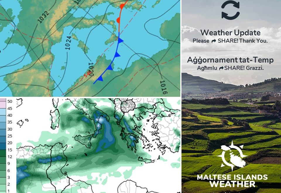
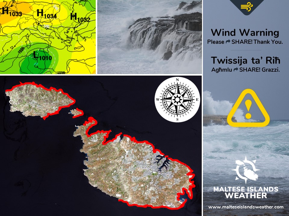
A low-pressure system will develop over the Gulf of Gabes this week. Meanwhile, an anticyclone will take hold of central Europe and the Balkans. This will cause a very strong, cool northeasterly wind to affect the Maltese Islands. The Gregale wind will reach gale-force at times. This gale-force wind warning is valid from 03:00 on Wednesday 20/03 till 15:00 on Thursday 21/03. This will be updated if and when necessary. The details below describe how the situation will develop over this time period.


Wednesday 20/03

03:00 to 06:00 – East Northeast Force 6/7

06:00 to 09:00 – East Northeast Force 7/8

09:00 to 12:00 – East Northeast Force 7/8

12:00 to 15:00 – East Northeast Force 7/8

15:00 to 18:00 – East Northeast Force 7/8

18:00 to 21:00 – East Northeast Force 7/8

21:00 to 00:00 – East Northeast Force 7/8


Thursday 21/03

00:00 to 03:00 – East Northeast Force 7/8

03:00 to 06:00 – East Northeast Force 7/8

06:00 to 09:00 – East Northeast Force 7/8

09:00 to 12:00 – East Force 7/8

12:00 to 15:00 – East Force 6/7


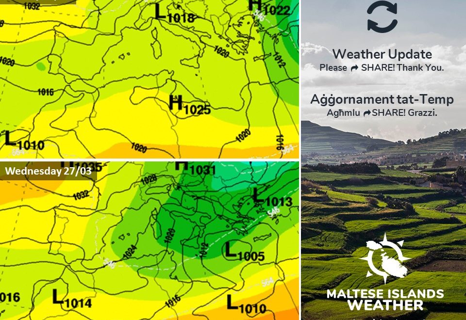
The peak gusts will blow across the Maltese Islands from the evening on Wednesday 20/03 through to morning on Thursday 21/03. At around mid-afternoon on Thursday 21/03, the wind will turn Southeast and decrease rapidly to Force 3/4.

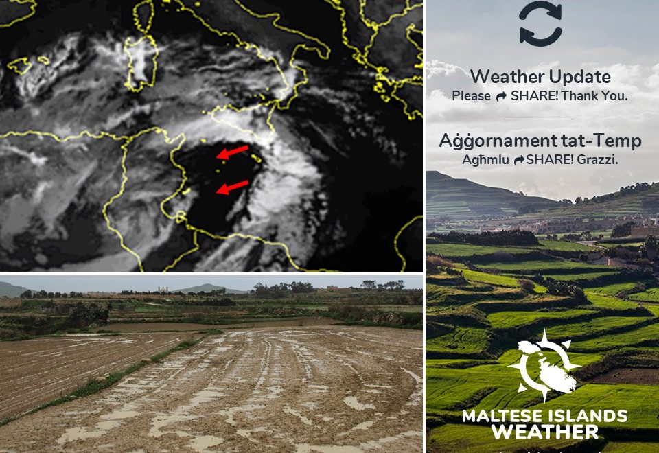
The sea will be very rough, with wave heights of up to 6.0 metres in peak gusts. The swell will be a low East. The map shows the length of coastline most exposed to this strong wind.


Sistema ta’ pressjoni baxxa se tkun qed tiżviluppa fuq il-Golf ta’ Gabes din il-ġimgħa. Sadattant, antiċiklun se jieħu postu fuq iċ-ċentru ta’ l-Ewropa u l-Balkani. Dan se jwassal biex riħ qawwi ħafna u frisk mill-Grigal jaffetwa lil Gżejjer Maltin. Din il-Gregalata se tilħaq il-qawwa ta’ riefnu kultant. Din it-twissija ta’ riefnu se tkun fis-seħħ minn 03:00 ta’ l-Erbgħa 20/03 sa 15:00 tal-Ħamis 21/03. Dawn id-dettalji jkunu aġġornament jekk ikun hemm bżonn. Id-dettalji ta’ hawn taħt juru kif se tiżviluppa s-sitwazzjoni matul il-ħin li ġej.


L-Erbgħa 20/03

03:00 sa 06:00 – Grieg il-Lvant Forza 6/7

06:00 sa 09:00 – Grieg il-Lvant Forza 7/8

09:00 sa 12:00 – Grieg il-Lvant Forza 7/8

12:00 sa 15:00 – Grieg il-Lvant Forza 7/8

15:00 sa 18:00 – Grieg il-Lvant Forza 7/8

18:00 sa 21:00 – Grieg il-Lvant Forza 7/8

21:00 sa 00:00 – Grieg il-Lvant Forza 7/8


Il-Ħamis 21/03

00:00 sa 03:00 – Grieg il-Lvant Forza 7/8

03:00 sa 06:00 – Grieg il-Lvant Forza 7/8

06:00 sa 09:00 – Grieg il-Lvant Forza 7/8

09:00 sa 12:00 – Lvant Forza 7/8

12:00 sa 15:00 – Lvant Forza 6/7


Il-buffuri l-aktar qawwija mistennija minn filgħaxija ta’ l-Erbgħa 20/03 sa filgħodu tal-Ħamis 21/03. Madwar wara nofsinhar tal-Ħamis 21/03, ir-riħ se jdur Xlokk u jonqos malajr ħafna biex isir Forza 3/4.

Il-baħar se jkun qawwi ħafna, b’mewġ għoli 6.0 metri fl-aktar buffuri qawwija. L-imbatt se jkun baxxa mill-Lvant. Il-mappa tindika l-kosta l-aktar esposta għal dan ir-riħ.