Updates

For the latest updates related to the weather in the Maltese Islands. So keep yourself updated by visiting this page frequently or like our Facebook page.

Updates

3 Hourly Forecast for the Feast of St. Joseph (19/03/2019)

00:00 to 03:00 – clear; 13 C to 12 C; North Northwest Force 2/3
03:00 to 06:00 – partly cloudy; 12 C to 11 C; Northwest Force 2/3
06:00 to 09:00 – partly cloudy; 11 C to 15 C; Northwest Force 3/4
09:00 to 12:00 – increasing cloudiness; 15 C to 18 C; Northeast Force 3/4
12:00 to 15:00 – increasing cloudiness; 18 C to 17 C; Northeast Force 3/4
15:00 to 18:00 – cloudy; 17 C to 15 C; Northeast Force 2/3
18:00 to 21:00 – cloudy; 15 C to 14 C; Northeast Force 2/3
21:00 to 00:00 – cloudy; 14 C to 13 C; Northeast Force 2/3

The feast of St Joseph is celebrated on the 19th of March and is a Public Holiday in the Maltese Islands.

Updates

This week: A typical week

After a short spell of mild weather, winter is expected to return to the Maltese Islands over the coming week. Once again, the central Mediterranean is expected to find itself sandwiched in between low pressure over Europe and high pressure over north Africa. These pressure patterns are a sign of the transition from winter to summer. Cooler air from over Europe will penetrate the central Mediterranean, lowering temperatures to the average for this time of year. Real-feels will be even cooler, as a result of a strong West Northwest wind which will blow on most days. Despite the cooler temperatures and stronger winds, no precipitation is anticipated across the Maltese Islands this week, as high pressure over north Africa inhibits the formation of rain clouds over our region. High pressure will once again take hold of the central Mediterranean over the weekend, promising another weekend of uninterrupted bright sunshine. Air temperatures are set to rise again, as southerly winds blow warm air from over north Africa towards the central Mediterranean. This will be the second heat spell of the season.

Taking a look at the weather across the Maltese Islands over the coming week, the average maximum temperature will be around 17°C, with a high for the week peaking at 21°C expected on Sunday 17/03. Meanwhile, the average minimum temperature will be 11°C, dipping to its lowest in the morning of Wednesday 13/03 at 10°C. This week should not see any precipitation. On the whole winds are expected to be strong from the West Northwest, with the strongest expected on Monday 11/03, Tuesday 12/03 and Thursday 14/03 when the West Northwest wind should reach Force 7/8.

Updates

Warmer Temperatures and Dust from the Sahara / Temperaturi Ogħla u Trab mis-Sahara

More signs that spring is here. An intense low pressure system over Algeria will bring us this year’s very first airborne fine desert sand. Strong southwesterly winds over Algeria will whip up a substantial amount of fine desert sand. Some of this will be carried to our shores by strong upper level winds. This fine desert sand will prevail over the central Mediterranean from Thursday 07/03 till Sunday 10/03. This will manifest itself as a reddish haze covering the sky. Additionally, winds blowing towards us from Algeria will cause temperatures to rise. The warmest of these four days will be Saturday 09/03, with maximum and minimum temperatures of 22°C and 14°C respectively. Meanwhile, a ridge of high pressure will remain stationary over the central Mediterranean. This should deviate showers and thunderstorms to mainland Europe, away from the Maltese Islands. With no rain-producing clouds expected to form around us, no fine desert sand is expected to be deposited. The wind will be mainly moderate from the Southeast to East. The situation will return to normal on Monday 11/03, when a strong Northwest wind brings cleaner air to the Maltese Islands.

Aktar sinjali tar-rebbiegħa. Sistema ta’ pressjoni baxxa intensa fuq l-Alġerija se ġġibilna l-ewwel trab fin fl-arja għal din is-sena. Irjiħat qawwija mill-lbiċ fuq l-Alġerija se jwassal biex ammonti sostanzjali ta’ ramel fin jiġi mirfugħ fl-atmosfera. Xi ftit minnu se jiġi mwassal fuq il-Gżejjer Maltin minn irjiħat qawwijin fil-livelli għoljin ta’ l-atmosfera. Dan it-trab fin fl-arja ser jippersisti mill-Ħamis 07/03 sal-Ħadd 10/03. Dan se jidher bħala sħaba fina ħamra li tgħatti s-sema. Dawn l-istess irjiħat ukoll, se jwasslu biex jogħlew xi daqsxejn it-temperaturi lokali. L-aktar sħuna minn dawn l-erba t’ijiem se jkun is-Sibt 09/03, bl-ogħla ta’ 22°C u l-anqas ta’ 14°C. Sadattant, firxa ta’ pressjoni għolja se tibqa stazzjonarja fuq iċ-ċentru tal-Mediterran. Dan mistenni jżomm il-maltemp il-bogħod mill-Gżejjer Maltin. Peress li mhux se jifforma sħab tax-xita fuqna, mhux se nkunu qed nistennew xita tal-ħamrija. Ir-riħ jkun l-aktar moderat mix-Xlokk għal-Lvant. Is-sitwazzjoni metejoroloġika tirritorna għan normal nhar it-Tnejn 11/03, meta riħ qawwi mill-Majjistral iġib arja nadifa fiċ-ċentru tal-Mediterran.

Updates

This week: Spring is the air

Spring is in the air! An area of high pressure advancing eastwards from over the Iberian Peninsula will head slowly eastwards, intensifying as it does so. The area of high pressure will mean plenty of sunshine throughout the week. By midweek, an area of low pressure should develop over north Africa. This area of low pressure will migrate north, passing close to the central Mediterranean in the process. It will pull a warm, dry, tropical air mass northwards. This will encourage air temperatures to rise to 20 C from Wednesday 06/03 onward. Nights will also be warmer. This will be the very first ‘heat spell’ of the year. Some grey clouds and airborne fine desert sand may also be present on these days. Otherwise, the skies will be generally sunny. Winds will be mainly from the South. Latest long-term charts reveal that the coldest and wettest days of winter are now behind us. Temperatures will be rising gradually, while rainfall slowly tapering off.

Taking a look at the weather across the Maltese Islands over the coming week, the average maximum temperature will be around 19°C, with a high for the week of 21°C expected on Friday 08/03. Meanwhile, the average minimum temperature will be 12°C, dipping to its lowest on the morning of Monday 04/03 at 10°C. This week should not see any precipitation. On the whole winds are likely to be light to moderate, with the strongest expected on Thursday 07/03, when the South wind reaches Force 4/5.

Updates

Stable weather for Carnival / Temp stabbli għall-Karnival

The meteorological situation for Carnival across the central Mediterranean is expected to be largely stable. The Maltese Islands will spend much of Carnival sandwiched in between high pressure over the western Mediterranean and low pressure over the eastern Mediterranean. The high pressure over the western Mediterranean will prevent storms of Atlantic origin from making their way to the central Mediterranean. This means mainly dry conditions for Carnival. The sky will be mainly sunny or partly cloudy on most days as well. The only downside is the wind. Being caught in between two different pressure systems, the wind will be fairly strong throughout much of Carnival. Temperatures will be warmer than of late, with highs set to rise above 16 C. Nights will not be as cold either, with lows expected to remain above 10 C on all nights. Having said this, real-feels will be pushed lower as a result of strong winds.

Taking a look at the weather across the Maltese Islands over Carnival, the average maximum temperature will be around 18°C, with a high of 20°C expected on the final day of Carnival. The average minimum temperature will be 11°C, dipping to its lowest of 10°C on Friday and Sunday. No precipitation is anticipated. Since air will be rushing from high pressure over the western Mediterranean to low pressure over the eastern Mediterranean, the wind will be mainly from the West. It will be at its strongest from late on Friday till late on Saturday, when it can reach Force 6/7 at times.

Is-sitwazzjoni metejoroloġika għal-Karnival madwar iċ-ċentru tal-Mediterran mistennija tkun għal-biċċa l-kbira tal-ħin stabbli. Il-Gżejjer Maltin se jqattgħu parti kbira mill-Karnival maqbudin bejn pressjoni għolja fuq il-punent tal-Mediterran u pressjoni baxxa fuq il-lvant tal-Mediterran. Il-pressjoni għolja fuq il-punent tal-Mediterran se twassal biex sistemi ta’ maltemp minn fuq l-Atlantiku jkunu miżmuma minn li jilħquna. Dan ifisser temp bla xita għal-parti l-kbira tal-Karnival. Is-sema se jkun il-biċċa l-kbira xemxi jew ftit imsaħħab f’ħafna mill-ġranet. L-unika żvantaġġ se jkun ir-riħ. Peress li se nkunu maqbudin bejn żewġ sistemi differenti ta’ pressjoni atmosferika, ir-riħ mistenni jkun kemmxejn qawwi f’ħafna mill-jiem. It-temperaturi se jkunu aktar sħan minn dan l-aħħar, bl-ogħla mistenni tilħaq 16 C. L-ijieli mhux se jkunu daqstant kesħin l-anqas, bl-anqas tkun ta’ aktar minn 10°C fl-iljieli kollha. Minkejja dan, it-temperaturi se jkunu jinħassu daqsxejn friski minħabba r-riħ qawwi.

Jekk nagħtu ħarsa lejn it-temp madwar il-Gżejjer Maltin għall-Karnival, ninnutaw kif it-temperatura massima medja se tkun ta’ madwar 18°C, bl-aktar ta’ 20°C mistennija fl-aħħar jum tal-Karnival. It-temperatura minima medja sejra tkun ta’ 11°C, bl-anqas tinżel għal-10°C nhar il-Ġimgħa u l-Ħadd. Mhux qed nistennew xita. Minħabba il-fatt li l-arja se tkun tonfoħ minn arja bi pressjoni għolja fuq il-punent tal-Mediterran lejn arja bi pressjoni baxxa fuq il-lvant tal-Mediterran, ir-riħ se jkun mill-Punent. Dan se jkun l-aktar qawwi minn tard il-Ġimgħa sa tard is-Sibt, meta dan ser jilħaq Forza 6/7 kultant.

Updates

Overnight rain and/or hail showers / Ħalbiet tax-xita u/jew silġ matul il-lejl

The remnants of an eastbound intense low pressure system that produced last Sunday’s severe gale have fueled the development of a weak area of low pressure over southern Italy. This will be moving south towards Libya in the coming hours, passing over the central Mediterranean as it does so. The Maltese Islands will be affected by this. As a result, a few isolated rain and/or hail showers are to be expected across parts of the Maltese Islands overnight. These may be heavy at times. The risk of rain will be highest from 19:00 on Monday 25/02 till 10:00 on Tuesday 26/02. Total rainfall may reach 15 mm in the hardest hit localities. Hail may be abundant. The meteorological situation should improve substantially by the afternoon, when bright sunshine should return to the Maltese Islands.

Il-fdalijiet tas-sistema ta’ pressjoni baxxa intensa li pproduċiet ir-riefnu sever qal-Ħadd li għadda issa tinsab riesqa lejn il-lvant. L-effetti tagħha fuq il-Gżejjer Maltin għadhom mhux lesti pero. Dan minħabba li din l-istess sistema żviluppat massa ta’ arja bi pressjoni baxxa dgħajfa fuq l-Italja ta’ isfel. Din se tkun riesqa bilmod lejn in-nofsinhar fid-direzzjoni tal-Libja fis-siegħat li ġejjin. Din se tgħaddi minn fuq iċ-ċentru tal-Mediterran fil-proċess. Il-Gżejjer Maltin se jkunu affetwati minn din. Riżultat ta’ dan, numru ta’ ħalbiet tax-xita u/jew silġ għandhom ikunu mistenni f’xi nħawi tal-Gżejjer Maltin matul il-lejl. Dawn jistgħu jkunu qawwijin kultant. Iċ-ċans ta’ xita se jkun l-ogħla minn 19:00 tat-Tnejn 25/02 sa 10:00 tat-Tlieta 26/02. It-total ta’ xita jista jilħaq 15 mm fil-lokalitajiet l-aktar milquta. Is-silġ jista jkun abbundanti. Is-sitwazzjoni metejoroloġika se taqleb għal-aħjar sa wara nofsinhar, meta x-xemx ser tirritorna lura lejn il-Gżejjer Maltin.

Updates

This Week: A general improvement in conditions

The intense low pressure system that brought with it one of the worst gales to ever occur over the Maltese Islands on Sunday 24/02 will continue moving east. Its impact will linger on for a day or two, however polska-ed.com. It will bring several showers to our shores, especially from late on Monday 25/02 till early on Tuesday 26/02. These will continue to be heavy, thundery and with hail at times.

The situation will improve greatly on Wednesday 27/02, when the Maltese Islands will come under the influence of high pressure over the western Mediterranean. There will be long hours of bright sunshine for at least three days. Temperatures will remain cold, however.

An area of low pressure may develop over the central Mediterranean on Saturday 02/03. This could bring a few isolated showers and a strong wind from the West Northwest to the Maltese Islands. This will be very short-lived and should not affect Carnival celebrations, as high pressure advancing eastwards from over the Iberian Peninsula restores fine weather on Sunday 03/03.

Taking a look at the weather across the Maltese Islands over the coming week, the average maximum temperature will be around 15°C, with a high for the week of 16°C expected over Carnival weekend. Meanwhile, the average minimum temperature will be 9°C, dipping to its lowest on the morning of Tuesday 26/02 at 7°C. The first half of this week will be rather wet, with total rainfall amounts expected to exceed 10 mm in the wettest localities. The second half of the forthcoming week will remain predominantly dry, with only a little light rain on Saturday 02/03. On the whole winds are likely to be moderate to strong, with the strongest expected on Wednesday 27/02 and Saturday 02/03, when the West Northwest wind reaches Force 6/7.

Updates

SEVERE GALE-FORCE WIND WARNING / TWISSIJA TA’ RIEFNU QAWWI ĦAFNA

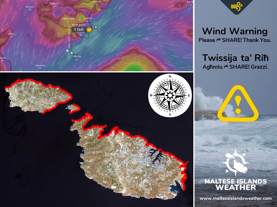
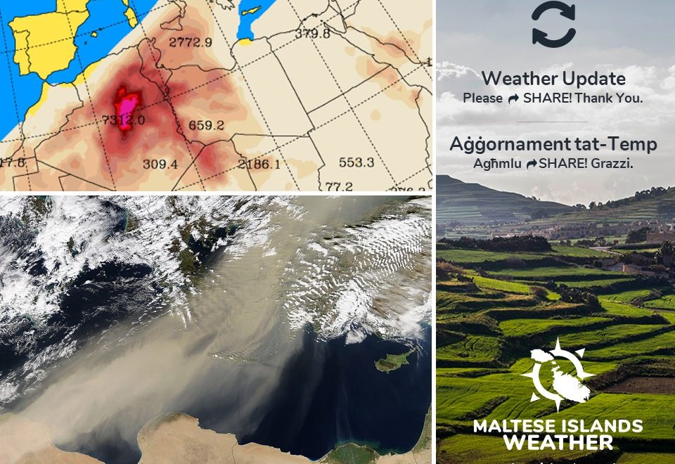
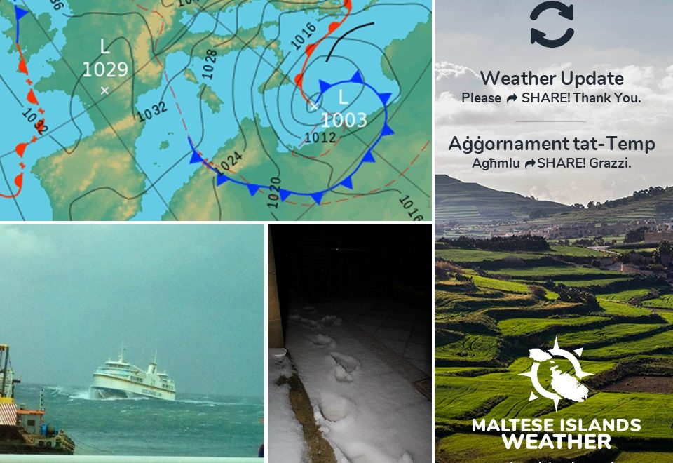
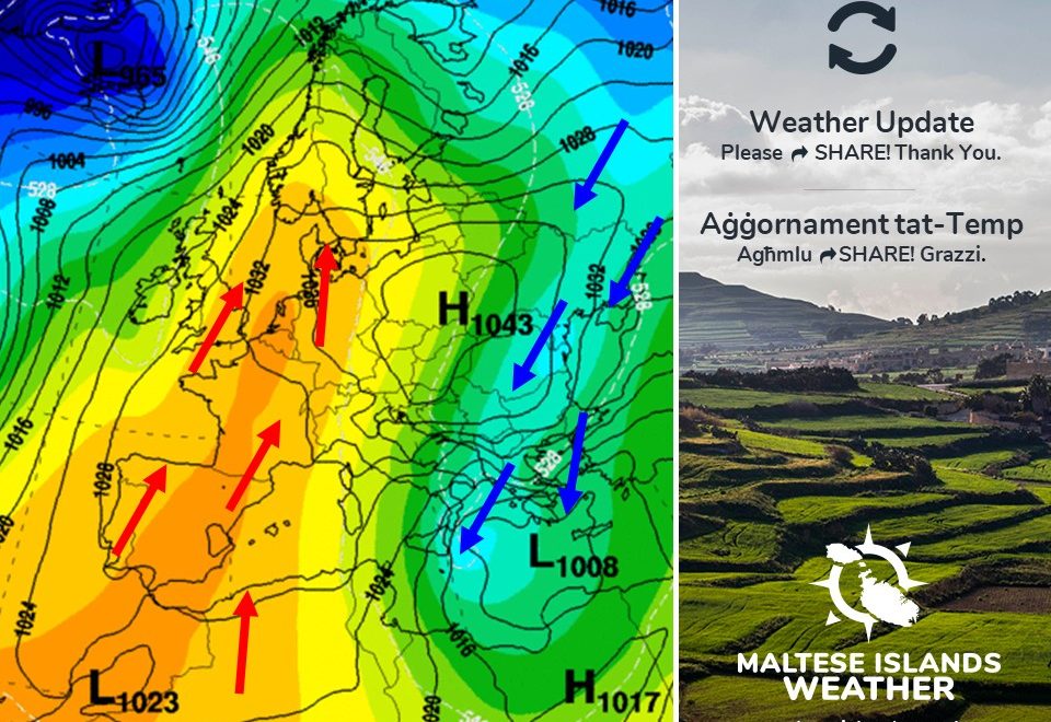
A very intense low pressure system from over the Balkans will affect the Maltese Islands over a period of around 24 hours. The low pressure system will be particularly intense as frigid air from over the Balkans clashes with very warm air from over the Sahara Desert right over the central Mediterranean. This low pressure system is expected to be one of the strongest we’ve had in a long time.

This strong wind warning is valid from 15:00 on Saturday 23/02 till 09:00 on Monday 25/02. This will be updated if necessary. The details below describe how the situation will develop over this time period.

Saturday 23/02

15:00 to 18:00 – North Force 6/7
18:00 to 21:00 – Northeast Force 7/8
21:00 to 00:00 – Northeast Force 8/9

Sunday 24/02

00:00 to 03:00 – Northeast Force 8/9
03:00 to 06:00 – Northeast Force 8/9
06:00 to 09:00 – Northeast Force 9/10
09:00 to 12:00 – Northeast Force 8/9
12:00 to 15:00 – Northeast Force 8/9
15:00 to 18:00 – Northeast Force 7/8
18:00 to 21:00 – Northeast Force 7/8
21:00 to 00:00 – Northeast Force 7/8

Monday 25/02

00:00 to 03:00 – Northeast Force 6/7
03:00 to 06:00 – Northeast Force 6/7
06:00 to 09:00 – Northeast Force 5/6

The peak gusts will blow across the Maltese Islands during the morning and early afternoon of Sunday 24/02.
The sea will be very rough, with wave heights of up to 10.3 metres in peak gusts. The swell will be a moderate to heavy Northeast. The map shows the area of coastline most exposed to this strong wind.


Sistema ta’ pressjoni baxxa intensa ħafna minn fuq il-Balkani mistennija li taffetwa lil Gżejjer Maltin matul perjodu ta’ 24 siegħa. Din is-sistema ta’ pressjoni baxxa se tkun partikolarment intensa minħabba li arja kiesħa minn fuq il-Balkani se tiltaqgħa ma’ arja sħuna ħafna minn fuq id-Deżert tas-Sahara fuq iċ-ċentru tal-Mediterran. Din is-sistema ta’ pressjoni baxxa se tkun l-aktar waħda qawwija fi żmien twil.

It-twissija ta’ riħ qawwi se tkun fis-seħħ minn 15:00 tas-Sibt 23/02 sa 09:00 tat-Tnejn 25/02. Din it-twissija se tkun aġġornament jekk ikun hemm il-bżonn. Id-dettalji ta’ hawn isfel jiddeskrivu kif għandha tiżviluppa s-sistema matul il-ħin imsemmi.

Is-Sibt 23/02

15:00 sa 18:00 – Tramuntana Force 6/7
18:00 sa 21:00 – Grigal Forza 7/8
21:00 sa 00:00 – Grigal Forza 8/9

Il-Ħad 24/02

00:00 sa 03:00 – Grigal Forza 8/9
03:00 sa 06:00 – Grigal Forza 8/9
06:00 sa 09:00 – Grigal Forza 9/10
09:00 sa 12:00 – Grigal Forza 8/9
12:00 sa 15:00 – Grigal Forza 8/9
15:00 sa 18:00 – Grigal Forza 7/8
18:00 sa 21:00 – Grigal Forza 7/8
21:00 sa 00:00 – Grigal Forza 7/8

It-Tnejn 25/02

00:00 sa 03:00 – Grigal Forza 6/7
03:00 sa 06:00 – Grigal Forza 6/7
06:00 sa 09:00 – Grigal Forza 5/6

Il-buffuri l-aktar qawwijin mistennija jaffetwaw lil Gżejjer Maltin matul filgħodu u kmieni wara nofsinhar tal-Ħadd 24/02.

Il-baħar se jkun qawwi ħafna b’mewġ ogħli 10.3 metri fl-aktar buffuri qawwijin. L-imbatt se jkun moderat għal-qawwi mill-Grigal. Il-mappa tindika l-kosta l-aktar esposta għal dan ir-riħ.

Updates

Stormy weekend / Weekend bil-maltemp

As explained earlier this week, the Maltese Islands are in for a very stormy weekend. This is the result of an intense low pressure system over the Balkans moving slowly towards the central Mediterranean. This system of low pressure will intensify further as it comes into contact with warmer air locally. This low pressure system will affect us on Saturday 23/02, Sunday 24/02 and Monday 25/02. Its primary impact will be a rapid drop in temperature. The maximum on all three days will struggle to reach 13 C. Nights will be very cold, with temperatures expected to dip to below 10 C. The coldest will be Sunday 24/02, with a 10 C high and 4 C low. Real-feels will be much lower, due to the strong wind. In fact, Sunday’s nighttime low may feel as cold as -2 C. This low pressure system is expected to pass close to the Maltese Islands. Apart from the cold temperatures, there will also be numerous periods of steady rain and/or hail that will be heavy and thundery at times. The hail will be mainly small, but may be in copious amounts at times. Much of the precipitation should fall from early evening on Saturday 23/02 till late evening on Sunday 24/02. Some isolated showers are also possible during the night from Friday 22/02 to Saturday 23/02. We could receive up to 25 mm of precipitation, with central and southern Malta expected to be the hardest hit. Another impact of this low pressure system will be an extremely strong wind from the North to Northeast. Saturday 23/02 will experience Force 4/5 to 5/6 winds from the North to North Northwest. Sunday 24/02 will see a Force 8/9 wind from the Northeast. Gusts may reach up to Force 10 in exposed areas. This could very easily result in disruptions to the ferry service from Malta to Gozo and from Valletta to Sicily.

The situation will start recovering on Monday 25/02. The wind will start decreasing gradually then, starting off at Force 8/9 from the Northeast and decreasing to Force 3/4 from the West Northwest by evening. Temperatures will also warm up to average on Monday 25/02. A little residual rainfall could still occur. Any relevant warnings will be issued in the coming hours.

Kif spjegat aktar kmieni din il-ġimgħa, il-Gżejjer Maltin għandhom jesperjenzaw tmiem il-ġimgħa ta’ maltemp. Dan se jkun ir-riżultat ta’ sistema ta’ pressjoni baxxa intensa li minn fuq il-Balkani se tersaq bilmod lejn iċ-ċentru tal-Mediterran. Din is-sistema ta’ pressjoni baxxa se tintensifika aktar hekk tiġi f’kuntatt ma arja aktar sħuna lokalment. Din is s-sistema ta’ pressjoni baxxa se taffetwana l-aktar nhar is-Sibt 23/02, il-Ħadd 24/02 u t-Tnejn 25/02. L-impatt primarju tagħha se jkun inżul drastiku fit-temperaturi. L-ogħla fit-tlett ijiem li huma se tbati biex tilħaq it-13 C. L-iljieli se jkun kesħin ħafna, bit-temperaturi mistennija jinżlu taħt l-10 C. L-aktar jum kiesaħ se jkun il-Ħadd 24/02, meta t-temperatura se titla sa 10 C u tinżel għal-4 C. Dawn se jkunu jinħassu ferm aktar kesħin minħabba r-riħ qawwi. Fil-fatt, il-Ħadd din se tkun tinħass daqs li kieku -2 C. Din is-sistema ta’ pressjoni baxxi mistenni tgħaddi qrib ħafna tal-Gżejjer Maltin. MInbarr it-temperaturi kesħin, se jkun hemm ukoll numru ta’ perjodi kontinwi ta’ xita u silġ, li se jkunu qawwijin u bir-ragħad kultant. Is-silġ se jkun pjuttost żgħir, imma jista jagħmel f’ammonti konsiderevoli kultant. Il-biċċa l-kbira tax-xita se taqa minn kmieni filgħaxija tas-Sibt 23/02 sa tard filgħaxija tal-Ħadd 24/02. Xi ħalbiet iżolati tax-xita xorta waħda jkunu possibli matul il-lejl ta’ bejn il-Ġimgħa 22/02 u s-Sibt 23/02. Nistgħu naraw sa 25 mm ta’ xita, biċ-ċentru u n-nofsinhar ta’ Malta jkunu l-aktar fir-riskju. Impatt ieħor ta’ din is-sistema ta’ pressjoni baxxa huwa r-riħ qawwi ħafna mit-Tramuntana għal-Grigal. Is-Sibt 23/02 se jesperjenza riħ ta’ Forza 4/5 għal-5/6 mit-Tramuntana għal-Majjistral it-Tramuntana. Il-Ħadd 24/02 se nesperjenzaw riħ ta’ Forza 8/9 mill-Grigal. Xi buffuri kapaċi jilħqu Forza 100 fejn espost. Dan jista faċilment jirriżulta f’dewmien fil-vjaġġi minn Malta għal-Għawdex u minn Malta għal-Sqallija.

Is-sitwazzjoni se tibda tirkupra it-Tnejn 25/02. Ir-riħ mistenni jnaqqa daqs xejn, u jibda minn Forza 8/9 mill-Grigal u jonqos għal-Forza 3/4 mill-Punent Majjistru sa filgħaxija. It-temperature wkoll mistennija jitilgħu mal-medja t-Tnejn 25/02. Xi ftit xita residwa tista taffetwana dakinhar. It-twissijiet kollha neċessarji se jinħarġu fis-sigħat li ġejjin.

Updates

Warmth from the Sahara, followed by cold from Siberia / Sħana mis-Sahara segwita minn ksieħ mis-Siberia

As forecast in the ‘Weekly Outlook’ issued on Sunday, the Maltese Islands are currently under the influence of an unstable air mass from over the Sahara Desert. This will be followed by a blast of cold air from Siberia, as was also forecast in Sunday’s ‘Weekly Outlook’.

With a maximum and minimum of 16 C and 9 C respectively, temperatures are currently at average levels for this time of year. The air is currently also quite hazy, and the sky is grey. This is all the impact of air being blown towards the central Mediterranean from the Sahara Desert. This state of affairs is anticipated to prevail till Saturday 23/02, when a low pressure system over the Balkans extends south towards our region. This will bring an abrupt change in weather conditions locally. A blast of cold air from over Siberia means that temperatures are set to plunge. For three to four days, from Sunday 24/02 till Wednesday 27/02, the Maltese Islands will experience highs in the region of 10 C to 13 C and lows that will range from 4 C to 7 C. In fact, Valletta is set to be colder than a number of capital cities at higher latitudes. Some isolated rain and/or hail showers are possible, especially on Saturday 23/02 and Sunday 24/02. The Northerly wind will be rather strong throughout the cold spell. It will reach Force 6/7 at its strongest, particularly on Saturday 23/02 and Sunday 24/02. The strong wind will drive real-feels to below 0 C on the coldest nights.

Normal temperatures are expected to return on Thursday 28/02 and last throughout Carnival time. The weather for Carnival time is expected to be mainly fine. More details about that at a later date in a separate post.


Kif imbassar fil-‘Weekly Outlook’ ta’ nhar il-Ħadd, il-Gżejjer Maltin bħalissa jinsabu fl-influewenza ta’ massa ta’ arja nstabbli minn fuq id-Deżert tas-Sahara. Din se tkun segwita minn massa ta’ arja kiesħa minn fuq is-Siberja, kif ukoll imbassar fil-‘Weekly Outlook’.

B’temperaturi massimi u minimu ta’ 16 C u 9 C rispettivament, it-temperaturi bħalissa jinsabu mal-medja għal dan iż-żmien tas-sena. L-arja hija mdaħħna u s-sema griż ukoll. Dan ukoll huwa l-impatt ta’ arja li laħqet iċ-ċentru tal-Mediterran minn fuq id-Deżert tas-Sahara. Din is-sitwazzjoni mistenni tippersisti sa nhar is-Sibt 23/02, meta sistema ta’ pressjoni baxxa minn fuq il-Balkani testendi ljn ir-reġjun tagħna. Din se ġġib magħha bidla drastika fit-temp. Massa ta’ arja kiesħa minn fuq is-Siberja tfisser li t-temperaturi se jaqgħu. Għal tlett ijiem jew erbgħa, mill-Ħadd 24/02 sa l-Erbgħa 27/02, il-Gżejjer Maltin se jesperjenza temperaturi massimi ta’ 10 C sa 13 C u dawk minimi ta’ 4 C sa 7 C. Fil-fatt, il-Belt Valletta se tkun aktar kiesħa minn bliet kapitali f’latitudni għola. Xi ftit ħalbiet tax-xita u/jew silġ huma possibli, speċjalment is-Sibt 23/02 u l-Ħadd 24/02. Ir-riħ mit-Tramuntana se jkun daqsxejn qawwi matul il-mewġa ta’ kesħa. Dan se jilħaq Forza 6/7, partikolarment is-Sibt 23/02 u l-Ħadd 24/02. Ir-riħ qawwi se jwassal biex it-temperaturi jinħassu ferm aktar kesħin. Filfatt, it-temperaturi minimi jafu jinħassu daqs li kieku taħt 0 C.

Temperaturi normali mistennija jirritornaw il-Ħamis 28/02 u jżommu matul iċ-ċelebrazzjonijiet tal-Karnival. It-temp għal-Karnival mistenni jkun sabiħ. Aktar dettalji dwar dan aktar tard u f’post separata.