Updates

For the latest updates related to the weather in the Maltese Islands. So keep yourself updated by visiting this page frequently or like our Facebook page.

Updates

This week: Starts off fine; ends up unstable

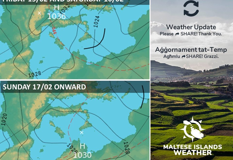
The first day of the week will be characterized by areas of high pressure that are extending from over the Azores to cover much of the Mediterranean. These will act to deviate storm systems north, ensuring fine weather on Monday 18/02. Anticyclonic conditions will mean clear skies and light winds for the Maltese Islands. Because no clouds are present to reflect sunlight during the day, there is more incoming solar radiation and temperatures rise to warmer than average levels. At night, the absence of cloud cover means that outgoing long wave radiation is left not blocked, allowing the nighttime lows to dip to well below average.

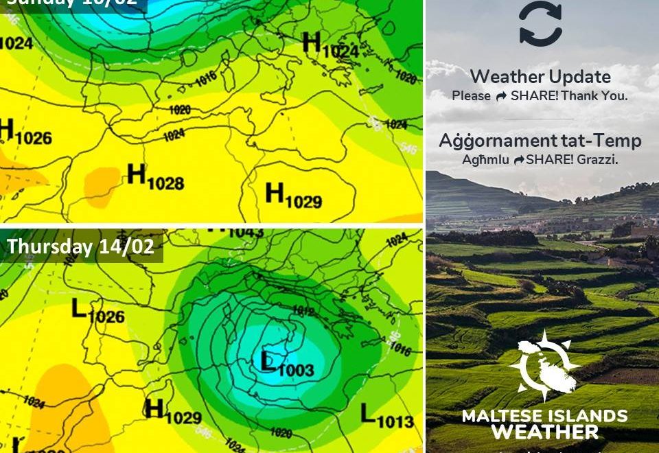
The areas of high pressure will begin to weaken on Tuesday 19/02. This will make way for two successive systems of low pressure to penetrate the central Mediterranean. These will mark the return of unstable weather conditions to the Maltese Islands.

The first will be a cut-off low from over north Africa. A light to moderate wind from the East to Southeast associated with this system will cause temperatures to rise to slightly above average around midweek. There will be the chance of a little light rain from this system, particularly on Thursday 21/02. Being of north African origin, any rainfall will deposit fine desert sand.

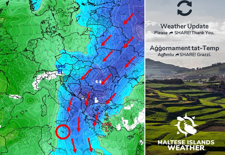
A more intense low pressure system from over the Balkans will manage to penetrate the central Mediterranean next weekend. This will restore wintry conditions to the Maltese Islands. Cold temperatures, light to moderate winds from the East to Northeast and clean rain showers will return by late on Friday 22/02. These will prevail throughout the weekend.

Taking a look at the weather across the Maltese Islands over the coming week, the average maximum temperature will be around 15°C, with a high for the week of 16°C expected in the afternoon of Tuesday 19/02. Meanwhile, the average minimum temperature will be 9°C, dipping to its lowest on the morning of Monday 18/02 at 6°C. The week ahead will remain predominantly dry, with only a little light rain on a few days. On the whole winds are likely to be light to moderate, with the strongest being on Thursday 21/02 and Sunday 24/02, when the Easterly wind reaches Force 4/5.

Updates

Low pressure to skim past the Maltese Islands / Pressjoni baxxa se tgħaddi bi żbrixx minn mal-Gżejjer Maltin

A trough of low pressure from over the Balkans will be extending south towards Libya, skimming past the Maltese Islands as it does so. This will bring a brief episode of instability to the Maltese Islands. In fact, a few showers are possible across parts of the Maltese Islands during the night from Friday 15/02 to Saturday 16/02. These showers will be very localized, and thus, not all of the Maltese Islands will be affected. Central and southern Malta is likely to receive the most rainfall, with total accumulations not expected to exceed 5 mm. Another impact this trough of low pressure will have on the central Mediterranean is a strong wind from the Northeast. Starting late in the evening on Friday 15/02, the Northeast wind will blow at Force 5/6. This will last only briefly, as it decreases to Force 4/5 by late afternoon on Saturday 16/02. No severe weather is being anticipated. The weather should stabilize again from Sunday 17/02, when high pressure returns to restore clear skies across the central Mediterranean. Temperatures will remain relatively cool over the coming week or so, especially at night. Lows will dip to 7 C / 8 C on most nights. Daytime highs will be milder, at 14 C /15 C.

Firxa ta’ pressjoni baxxa minn fuq il-Balkani se testendi lejn il-Libja, biex b’hekk tgħaddi żbrixx minn mal-Gżejjer Maltin. Din se ġġib magħa episodju qasir ta’ instabbilita’ għal Gżejjer Maltin. Filfatt, xi ftit ħalbiet iżolati tax-xita jistgħu jolqtu partijiet mill-Gżejjer Maltin matul il-lejl ta’ bejn il-Ġimgħa 15/02 u s-Sibt 16/02. Dawn il-ħalbiet tax-xita se jkunu lokaliżżati ħafna, u għalhekk, mhux se jolqtu kullimkien. Iċ-ċentru u n-nofsinhar ta’ Malta mistennija li jkunu l-aktar li jintlaqtu minn dawn. It-total ta’ xita mhux mistenni jaqbeż il-5 mm. Impatt ieħor ta’ din il-pressjoni baxxa fuq iċ-ċentru tal-Mediterran se jkun riħ qawwi mill-Grigal. Minn tard filgħaxija l-Ġimgħa 15/02, ir-riħ mill-Grigal se jilħaq Forza 5/6. Dan se jdum biss għal-ftit ħin pero, hekk kif jonqos għal-Forza 4/5 minn tard wara nofsinhar is-Sibt 16/02. Mhux qed nistennew maltemp sever. It-temp għadu jistabiliżża ruħu mill-ġdid nhar il-Ħadd 17/02, meta arja bi pressjoni għolja tirritorna biex tiżgura sema ċar madwar i-ċentru tal-Mediterran. It-temperaturi mistennija jkunu relattivament friski matul il-ġimgħa li ġejja, speċjalment billejl. L-anqas se tinżel għal 7 C / 8 C f’bosta ljieli. L-ogħla se tkun ta’ 14 C / 15 C.

Updates

Cold spell ahead of us / Mewġa ta’ kesħa oħra

Latest weather models indicate that the Maltese Islands will be caught in between high pressure over central Europe and low pressure over the eastern Mediterranean. The interaction between these two will generate very cold air currents from over Russia, across the Balkans, and towards the eastern and central Mediterranean. This is shown by the arrows on the chart below. This means a cold spell for the Maltese Islands. Starting from Tuesday 12/02, daytime highs will struggle to reach 13 C. Nighttime lows will dip to 5 C / 6 C. Real-feels will be far lower, with temperatures on the coldest nights feeling as cold as 0 C. These cold temperatures are expected to prevail for around a week. The next significant rainfall is still expected to affect us on Saturday 16/02 and Sunday 17/02.

L-aħħar mudelli tat-temp jindikaw li l-Gżejjer Maltin se jkunu maqbudin bejn pressjoni għolja lejn iċ-ċentru ta’ l-Ewropa u pressjoni baxxa fuq l-lvant tal-Mediterran. Din se twassal biex jifformaw kurrenti ta’ arja kiesħa ħafna minn fuq ir-Russja, għal fuq il-Balkani, u lejn il-lvant u ċ-ċentru tal-Mediterran. Dan huwa ndikat mill-vleġġeġ fuq l-istampa ta’ hawn taħt. Din is-sitwazzjoni tfisser mewġa ta’ ksieħ għal-Gżejjer Maltin. Minn nhar it-Tlieta 12/02, it-temperatura matul il-jum se tbati biex tilħaq 13 C. Matul il-lejl, din se tonqos għal 5 C / 6 C. Din se tinħass ferm aktar kiesħa, bit-temperaturi fl-aktar iljieli kesħin ikunu jinħassu daqs li kieku 0 C. Dawn it-temperaturi kesħin se jipperisstu għal madwar ġimgħa. Ix-xita sinifikanti li jmiss għadha mistennija tilħaqna nhar is-Sibt 16/02 u l-Ħadd 17/02.

Updates

A brief break from the bad weather / Waqfa qasira mill-maltemp

A wave of bad weather across the central Mediterranean has come to an end. A ridge of high pressure has extended across our region from today. This means a spell of fine weather for the Maltese Islands. Starting today, the weather will be clearer and temperatures warmer. Maximum daytime highs will reach 16 C to 18 C. Nighttime lows, at 10 C to 12 C, will still feel rather cool, however, because of a heavy dewfall on some nights. The wind will be mainly light to moderate from the West to Northwest. This state of affairs will prevail till Wednesday 13/02, when a blast of colder Siberian air reaches the central Mediterranean. Starting from Wednesday 13/02, the weather in the Maltese Islands will remain mainly sunny but very cold. Maximum daytime highs will dip to 11 C to 13 C. Nighttime lows will fall to 5 C to 7 C. The wind will be moderate to strong from the West to Northwest. There are no significant rainfall events on the horizon.  

Il-mewġa ta’ maltemp madwar iċ-ċentru tal-Mediterran waslet fi tmiemha. Firxa ta’ pressjoni għolja se tkun qed testendi għal fuq ir-reġjun tagħna mill-lum. Dan ifisser waqfa ta’ temp sabiħ għal-Gżejjer Maltin. Nibew mill-lum, it-temp se jkun aktar ċar u t-temperaturi aktar sħan. L-ogħla matul il-jum se titla għal 16 C sa 18 C. L-anqas billejl, ta’ 10 C sa 12 C, se jkunu jinħassu daqsxejn kesħin, pero, minħabba nida matul il-lejl. Ir-riħ għandu jkun ħafif għal moderat mill-Punent għal-Majjistral. Din is-sitwazzjoni se tippersisti sa l-Erbgħa 13/02, meta massa ta’ arja kiesħa ferm mis-Siberja mistennija tilħaq iċ-ċentru tal-Mediterran. Mill-Erbgħa 13/02, it-temp madwar il-Gżejjer Maltin se jibqa l-biċċa l-kbira xemxi, imma jsir kiesaħ ħafna. L-ogħla matul il-jum se tinżel għal 11 C sa 13 C. L-anqas billejl se tkun ta’ 5 C sa 7 C. Ir-riħ se jkun moderat għal-qawwi mill-Punent għal-Majjistral. Ma jidher li se jkollna l-ebda xita sinifikanti fil-futur qrib.