
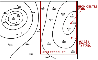
ANTICYCLONES
A high pressure system, also known as an anticyclone occurs when the weather is dominated by stable conditions. Under anticyclonic conditions, the air is descending, forming an area of high pressure at the surface. Because of these stable conditions, cloud formation is inhibited, so the weather is usually settled with only small amounts of cloud cover. Anticyclones can be identified on weather charts as an often large area of widely spaced isobars, where pressure is higher than surrounding areas.
There is a difference between anticyclones in winter and anticyclones in summer. In winter, the clear conditions and light winds associated with anticyclones can lead to frost and fog. The clear skies allow heat to be lost from the surface of the earth through radiation, allowing temperatures to fall steadily overnight, leading to air or ground frosts. Light winds along with falling temperatures encourage fog to form. In summer, the clear conditions associated with anticyclones can bring long sunny days and warm temperatures. The weather is normally dry, although occasionally, very hot temperatures can trigger thunderstorms.
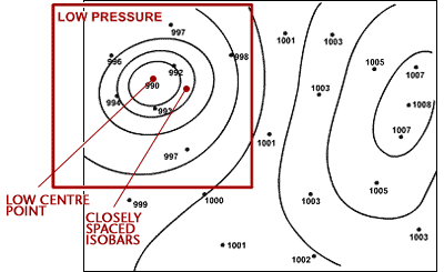
LOW PRESSURE SYSTEMS
A low pressure system, also known as a depression occurs when the weather is dominated by unstable conditions. Under a depression air is rising, forming an area of low pressure at the surface. This rising air cools and condenses and helps encourage cloud formation, so the weather is often cloudy and wet. Depressions can be identified on weather charts as an area of closely spaced isobars, often in a roughly circular shape, where pressure is lower than surrounding areas. They are often accompanied by fronts.
FRONTS
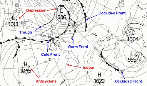
Large air masses with similar temperatures and humidity form in different parts of the world. They are classified by temperature as arctic, polar, tropical or equatorial and by their humidity level as continental (dry) or maritime (moist). Air masses of different properties do not mix together, forming a low pressure system. The sharp boundary between air masses is called a front. There are three types of fronts: cold fronts, warm fronts and occluded fronts.
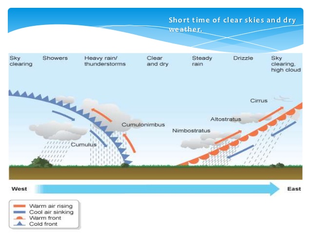
A warm front indicates that warm air is advancing and rising up over colder air. This is because the warm air is less dense than the cold air. Therefore, warm fronts occur where warmer air is replacing colder air at the surface. As the warm front approaches a gradual deterioration in weather conditions occurs. Clouds gradually lower from higher cirrus, through altostratus, to stratus and nimbostratus at the front. There is often a prolonged spell of rainfall which is often heavy. Behind the warm front the rain becomes lighter and the sky remains cloudy.
A cold front indicates that cold air is advancing and pushing underneath warmer air at the surface. This occurs because the cold air is denser than the warm air. Therefore, cold fronts occur where cooler air is replacing warmer air at the surface. The impact associated with a cold front is much shorter lived than that with a warm front. As there is often a lot of cloud in the warmer air ahead of the cold front, there is often little indication of the approaching cold front. As the front passes temperatures fall and there is often a short spell of very heavy rain, sometimes with embedded thunderstorms and cumulonimbus clouds. Behind the front the weather is much brighter with broken clouds but occasional showers. Winds veer with the passage of the cold front and are often strong and gusty, especially near showers. Pressure rises throughout the approach and passage of the cold front.
In a mature depression the warm front normally precedes the cold front. Cold fronts generally travel much quicker than warm fronts, and eventually it will catch up with the warm front. Where the two fronts meet, warm air is lifted from the surface and an occlusion is formed. An occlusion can be thought of as having similar characteristics to both warm and cold fronts. The weather ahead of an occlusion is similar to that ahead of a warm front, whilst the weather behind is similar to that behind a cold front.
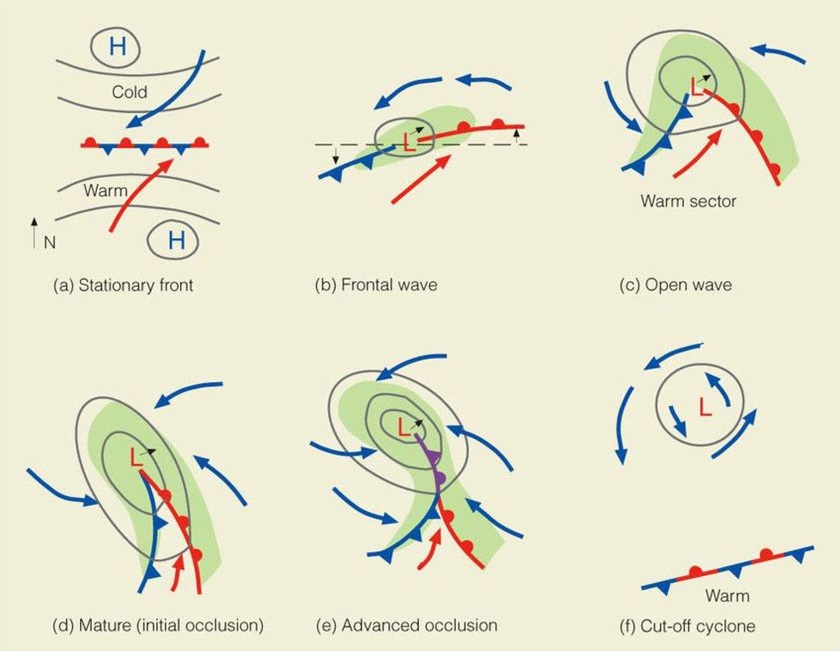
LIFE CYCLE OF LOW PRESSURE SYSTEMS
- Cold and warm air masses converge and move side by side in opposing directions. The first signs of instability manifest themselves here. This is referred to as an embryo low pressure system.
- The warm air mass begins to rise over the cold air, creating a low pressure system. The air masses begin to rotate. Clouds and precipitation form.
- The cold front pushes under and lifts, or occludes , the warm front.
- Warm air is completely lifted off the surface. The cold air cuts off the supply of warm air. Precipitation and wind subside. The system dissipates.
WEATHER SEQUENCE IN A LOW PRESSURE SYSTEM
Most low pressure systems have a warm and cold front. More mature depressions may also have an occluded front. This section will show what weather one expects as the low pressure system advances across an area of the world.

0 comments
Write a comment